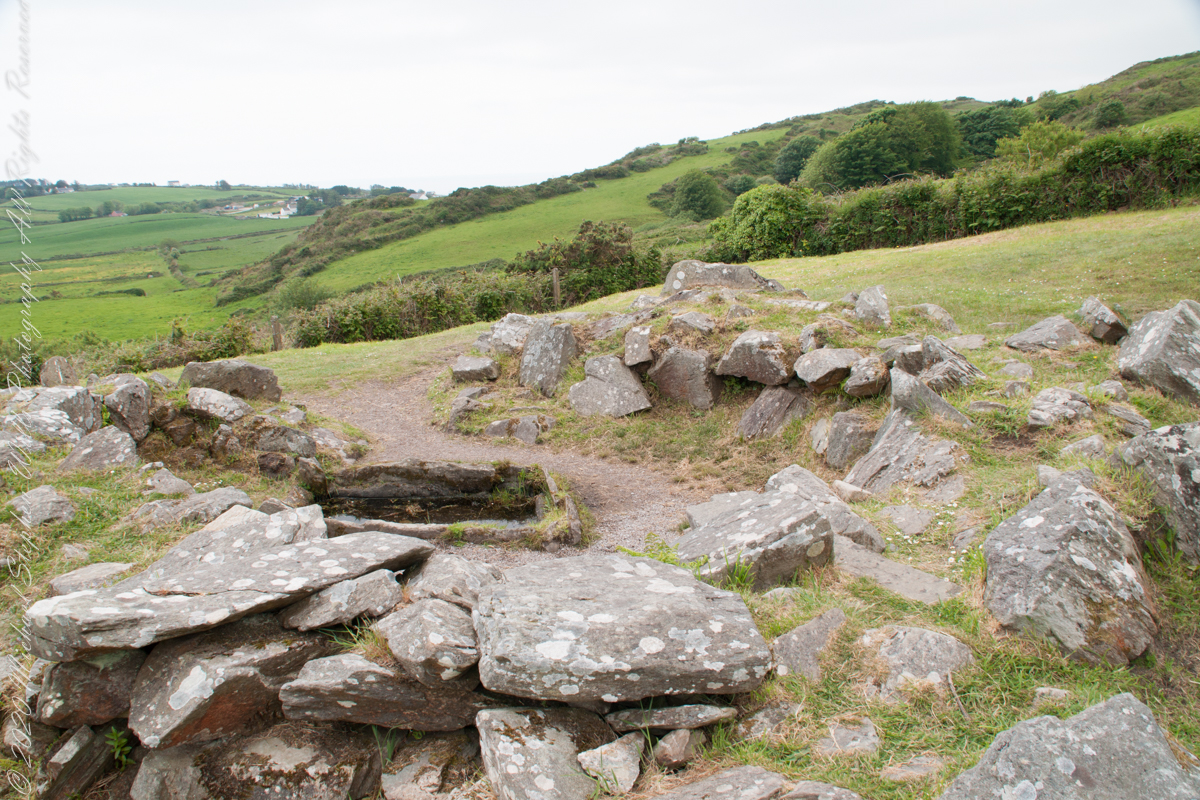
Notice the groupings of visitors in the middle distance of Pam’s photograph, gathered around remains of late Bronze age elements.
Click pic for a larger view, in a new tab. When using WordPress Reader, you need to open the post first.
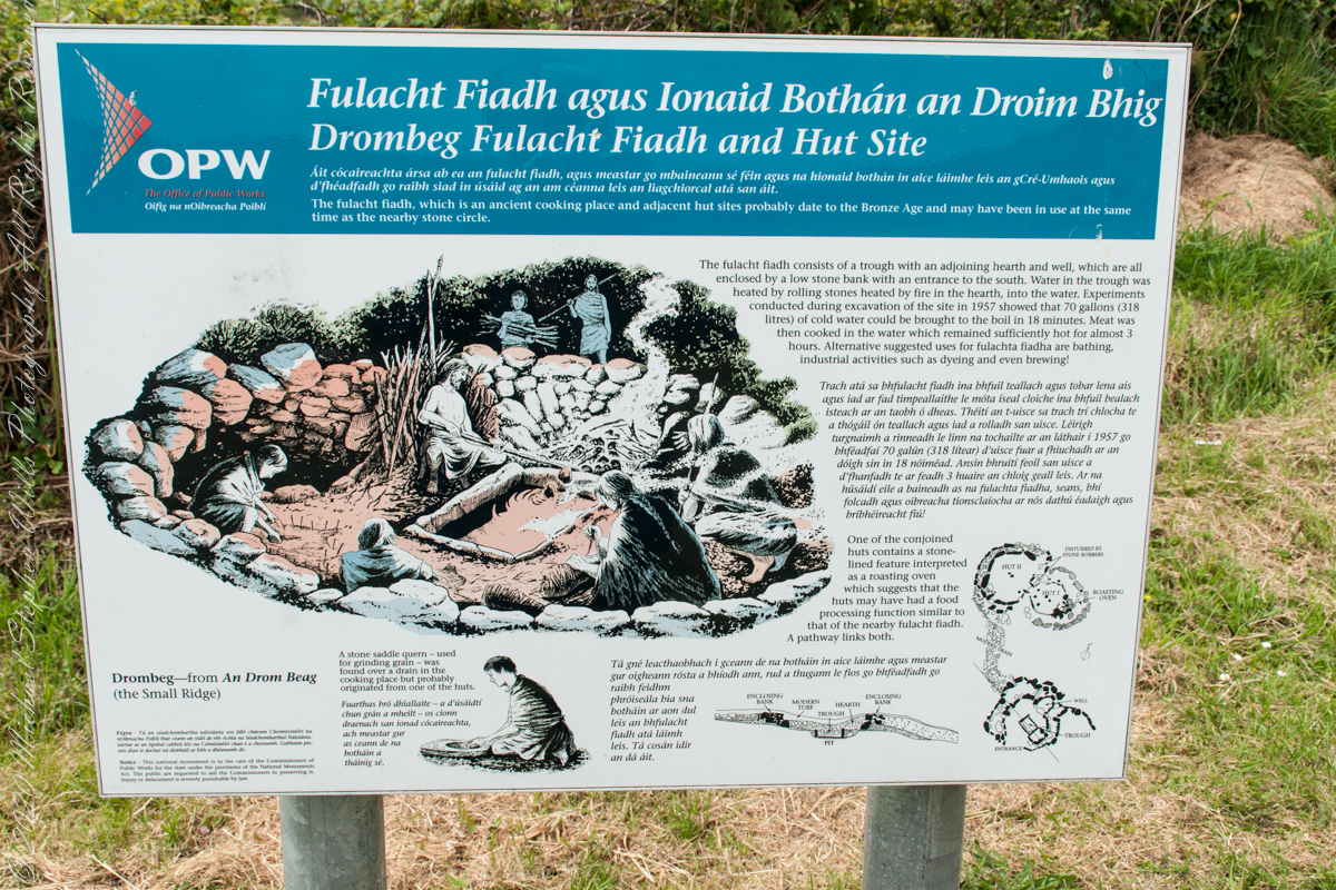
There is a sign to explain…
Trach atá sa bhfulacht fiadh le brutháil teallach agus tobair lena ais agus atá dúnta ag falla cloiche íseal le hiontráil soir. Líonadh an traid trí clocha te a théamh ar theallach agus a n-aistriú isteach sa traid lán le huisce fuar. Léiríodh le turgnamh a rinneadh le linn na tochailte ar an áit i 1957 gur féidir 70 galún (318 lítear) d’uisce fuar a thabhairt chun boil in 18 nóiméad. Ansin bhíodh feoil ann is a cócaireacht. Maireann an t-uisce seo te ar feadh 3 n-uaire an chloig. Cuirtear úsáidí eile sa bhfulacht fia ar aghaidh, mar shampla folcadáin, ceardaíocht amhail ruaimniú agus grúdaireacht.
In modern Ireland the word fulacht means barbeque and the archeological sites with characteristics in common, such as a water source, health and pit, are named “Fulacht fiadh,” derived from Old Irish sources. In all cases the link is to some kind of preparation activity involving heat and moisture. Found throughout Ireland, Great Britan and the Isle of Man where the sites are called burnt mounds. The Drombeg Fulacht fiadh exemplifies all characterists. There is a horseshoe shaped rock walled/banked, now a remnant, enclosure, entrance to the south. In the middle is a pit, at Drombeg lined with rock, a spring on one side, a hearth on the other. A stone saddle quern, used for grinding grain, was nearby Adjacent huts, rock walls with post holes, do not suggest a settlement, but rather a temporary use.
View of entrance to the south from above the spring, visible is the rock lines cooking pit filled with ground water.
Kinsale, a historic seaport in County Cork, showcases unique architecture and geography, with its streets and houses built on steep inclines near the river Bandon.
The first of a series of idiosyncratic posts from a 2014 walking tour of Kinsale.
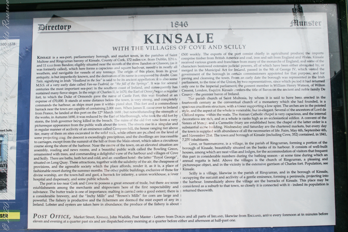
Text from an poster behind glass accessible to all and sundry. Directory 1846 Munster, Kinsale with the villages of Cove and Scilly. Kinsale is a seaport, parliamentary borough and market town in the parishes of Saint Multose and Ringcurran barony of Kinsale, County of Cork, 172 miles s.w. from Dublin, 121/2 s and 11 e.s.e. from Bandon; eligibly situated near the mouth of the river Bandon or Glasson, (as it was formerly called), which here forms a capacious and square harbor, accessible in nearly all weathers, and navigable for vessels of any tonnage. the origin of this place, from its great antiquity, is but imperfectly known, and the derivation of its name is compassed by doubt. Cean Taile (Cionn tSáile), signifying in Irish “Headland in the Sea” is said to be its ancient appellation. (see more in the photograph).
An informative poster behind glass accessible to all and sundry. Text: Directory 1846 Munster, Kinsale with the villiages of Cove and Scilly. Kindale is a sea-0ort, parlimentary borough and market town i the parishes of Saint Multose and Ringcurran barony of Kinsale, County of Cork, 172 miles s.w. from Dublin, 121/2 s and 11 e.s.e. from Bandon; elibibly situated near the mouth of the river Bandon or Glasson, (as it was formerly called), which here forms a capacious and square harbour, accessible in nearly all weathers, and navigable for vessels of any tonnage. the originn of this place, from its great antiquity, is but imperfectly known, and the derivaltion of its name is compassed by doubt. Cean Taile, signifying in Irish “Headland in the Sea” is said to be its anceient appellation. (see more in the photograph)./
Here we are on Emmet Place. There is a row of houses built along a steep alley named “The Stoney Steps.” At top is the aptly named Higher O’Connell Street.
The Gallery Kinsale
13 Main Street
Kinsale
West Cork
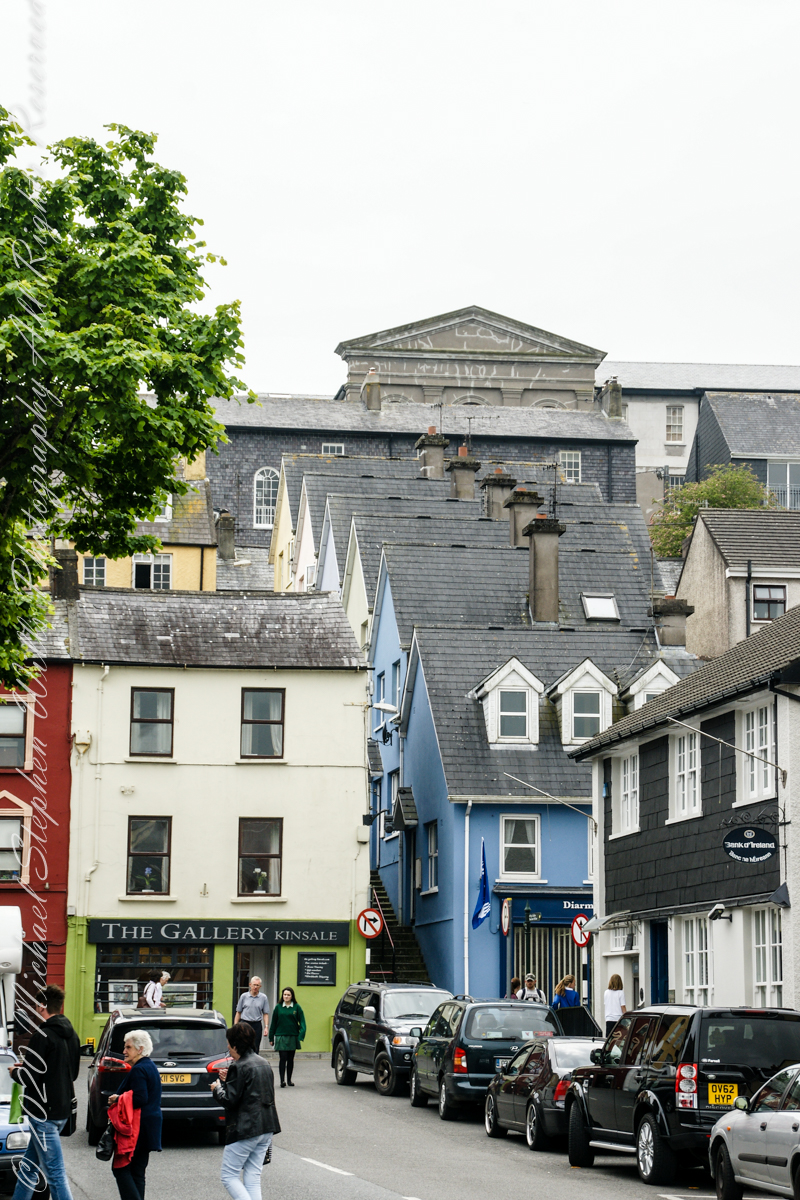
Ireland. From an informative poster…The streets rise in a singular and in regular manner of acclivity of an eminence called Compass Hill, the house ranging tier above tier, many of them on sites excavated in the solid rock, while other are perched on the level of some projecting crag: the descent is exceedingly precipitous, and the dwelling are inaccessible to carriages, except from the summit of the hill or from Main street, which takes a circuitous course along the shore of the harbor.
From the informative poster…The streets rise in a singular and in regular manner of acclivity of an eminence called Compass Hill, the house ranging tier above tier, many of them on sites excavated in the solid rock, while other are perched on the level of some projecting crag: the descent is exceedingly precipitous, and the dwelling are inaccessible to carriages, except from the summit of the hill or from Main street, which takes a circuitous course along the shore of the harbor.