A span of 10,000 years spreads between now and the first possibility of settlement on the island of Eire, then swept clean to bare rock by the weight of ice. Current scholarship of the Dún Aonghasa ruins, Inishmore, County Galway, the Irish Republic place a settlement within the inner of the four dry stone rings after 6,500 years (1,500 BC or 3,500 years ago). By way of scale, the first settlement took about 30 times the duration of the U.S. Constitution ratification through 2025: the last state, Rhode Island, ratified the Constitution 1789.
By 700 BC, 2,700 years ago, a series of upright, closely placed stones, were erected between the second and third rings called a cheval de fries field (“Frisian horses” in English) today, this defensive structure evokes the enormous scale of the struggles around this place of defense.
This is a portion of that field, I believe, taken as Pam and I approach the inner ring entrance, walking a wide path cleared of barriers. Click the photograph for a larger image with caption.
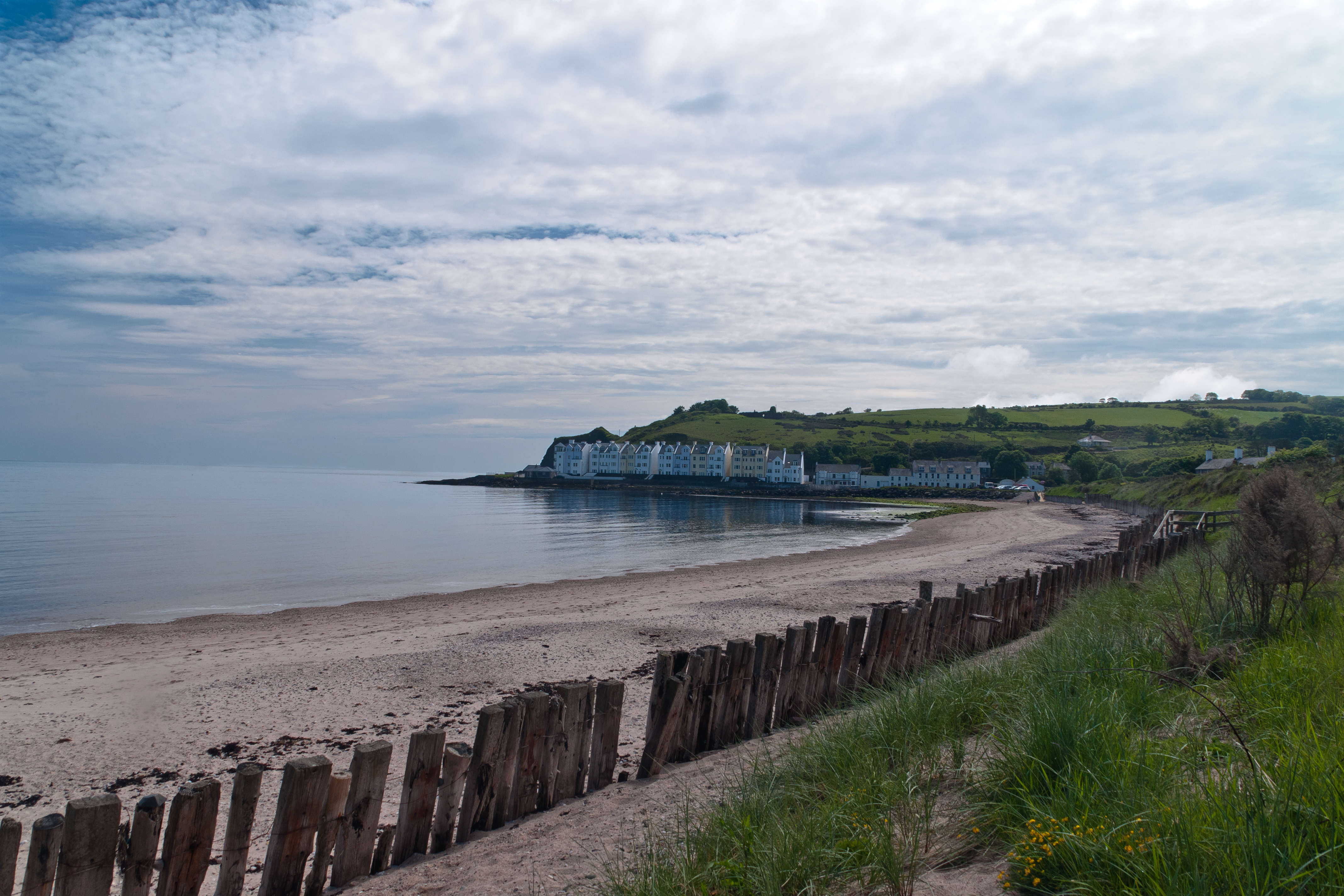
Cushendun (from Irish: Cois Abhann Doinne, meaning “foot of the River Dun”) is a small coastal village in County Antrim, Northern Ireland. It sits off the A2 coast road between Cushendall and Ballycastle.
It has a sheltered harbor and lies at the mouth of the River Dun and Glendun, one of the nine Glens of Antrim. The Mull of Kintyre in Scotland is only about 15 miles away across the North Channel and can be seen easily on clear days.
In the 2001 Census it had a population of 138 people. Cushendun is part of Causeway Coast and Glens district.
SONY DSC
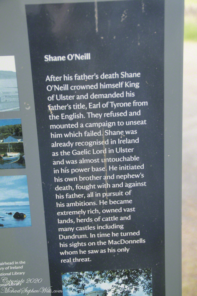
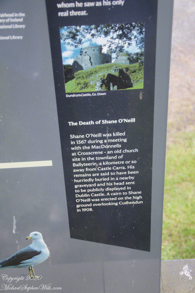
Here are several of the information placards near the harbor explaining some local history.
.
Ballyteerin townland, where Shane O’Neill was killed, is on the road to Torr Head.
Reference: Wikipedia, “Cushendun.”
Enter your email to receive notification of future postings. I will not sell or share your email address.
Copyright 2025 All Rights Reserved Michael Stephen Wills
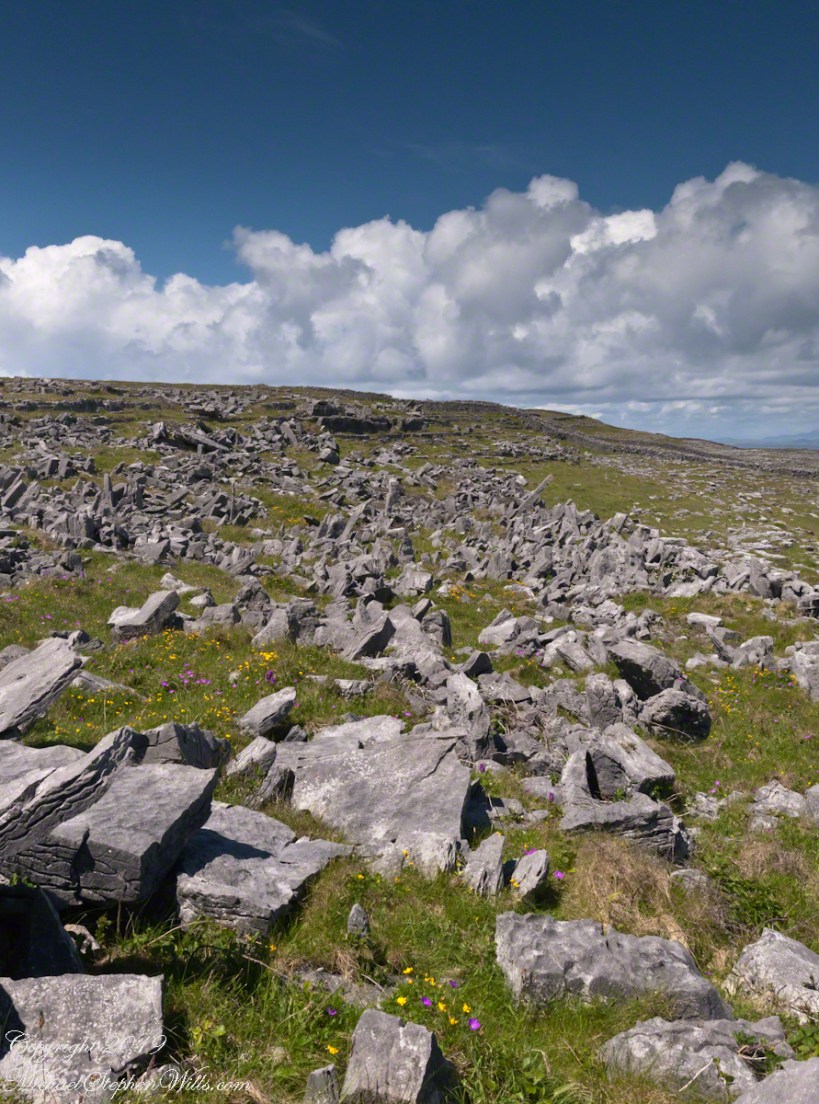
From the commanding location of Dún Aonghasa, looking northeast across Inishmore, the logic of the ancients becomes clear. No better vantage could be found—land unfurling like a hand toward Galway Bay, cottages nestled in green folds, clouds billowing above like sails caught mid-journey. A place of presence. A place of permanence.
Perched high on the cliff’s edge, the fort behind, the Atlantic at the back, the wind carried stories—unwritten, unspoken, but felt in the bones. Below, stone walls divided the island into patterns of memory. Fields outlined in rock, laid long ago by hands familiar with hardship and patience. The sea’s pulse echoed faintly in the distance, as steady and unfathomable as time itself.
No words were needed in that moment. Just the hush of sky and stone. Cottages, bleached bright by limewash—kalsomine, the old name still whispered by some—stood resilient against the elements, each one a witness to generations. Each one seemed to carry a personal reverence, a tenderness carved into the landscape.
Paths led gently inland, where wind slowed and voices from distant homes rose faintly through the open air. Along those paths, the rhythm of island life could be read in hoof prints, scattered wool, and the sharp, clean edges of hand-cut stone. There, among the hedges of limestone and wild grass, the living and the lost felt close.
The cloud cover shifted constantly. Shadows passed like thoughts across the land. Toward the shore, the sky opened wide. A silence filled the lungs, as bracing and deep as the Atlantic itself. Time seemed to slow, the mind slipping into the rhythm of the land.
Limestone pavement, rough beneath the boots, told its own tale of erosion and survival. That the earth here could sustain even the most modest farming seemed improbable. Yet here it was: a testament to stubborn hope and quiet ingenuity. In that quiet, ancient energy rose—something older than the fort, older than language. A pulse shared with the rock and wind.
The fort eventually came back into view—perched as if grown from the cliff itself, curved walls enclosing nothing but air and sky. I perceived no defensive bluster, only presence. And what a view it commanded. On days like this, the clouds formed towering cathedrals overhead, white and gold in the sun. Below, the cottages and fields seemed miniature, perfect, enduring.
The wind played echoes of prayer, lullaby, and laughter mingled with the call of seabirds. The thought came that nothing here was ever truly lost—only layered. Generation upon generation, each leaving some trace: a stone placed just so, a wall mended one final time, a cottage roof patched for another winter.
Here, even the air speaks. It moves gently but insistently, brushing the cheeks and stirring something ancient within the chest. Beneath it, the island breathes: not loudly, not urgently, but with the slow, deep rhythm of the tides.
As the sun dipped slightly westward, light changed across the fields, cottages glowing warm against darkening green. The wind softened. The clouds drifted, still massive but no longer looming. Time to return. A glance back offered one last communion with sky, stone, and silence.
Inishmore, on that day had been absorbed. Understood not with the mind, but with something quieter. Something that listens without need for words.
As I stood within the hallowed confines of Saint Fin Barre’s Cathedral in Cork City, Ireland, I found myself drawn to the intricate artistry that tells the story of faith, resilience, and devotion. The figures and symbols within this magnificent edifice bring to life the history of Saint Fin Barre as well as the broader narrative of Christian tradition and its enduring influence on the region.
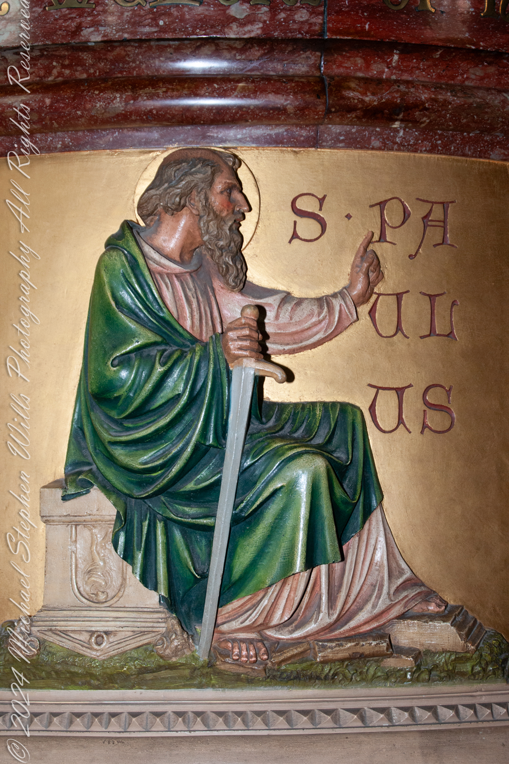
Near the entrance, the cylindrical pulpit’s relief figures of five evangelists captured my imagination. Here was the relief of Saint Paul seated with his characteristic sword, a symbol of both his martyrdom and the “sword of the Spirit” from chapter 6, verse 17 of the New Testiment Epistle to the Ephesians. His hand gestures toward the heavens, as if calling upon divine guidance to symbolize his role as an intermediary or messenger of God’s revelation. The rich green of his robes, juxtaposed against the golden background, speaks of hope, growth, and the everlasting promise of salvation. Here I found Saint Paul embodying the courage and conviction needed to preach and defend the faith—a sentiment that resonates deeply in the cathedral’s design and purpose.
Saint Paul
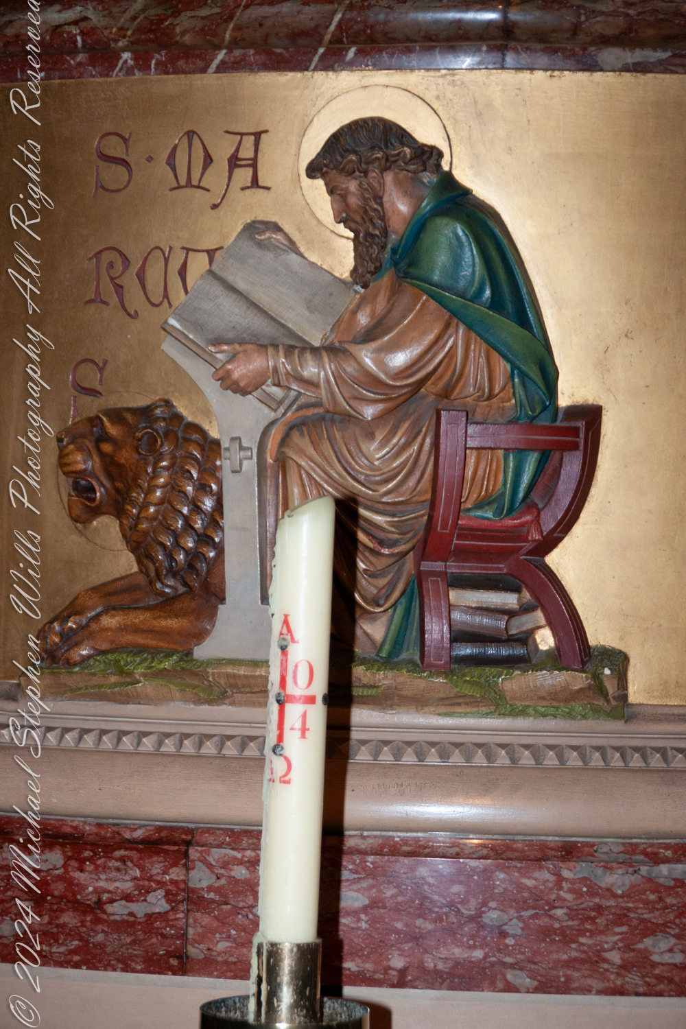
Rounding the circle, another relief brought Saint Mark to life. With the lion at his side, Saint Mark writes intently, reminding us of his contributions to the Gospels. The warm, earthy tones of his attire and the contemplative tilt of his head evoke the diligence and introspection of a writer who draws inspiration from divine revelation. The lion, its expression both fierce and loyal, represents courage and the Gospel’s enduring power.
Saint Mark
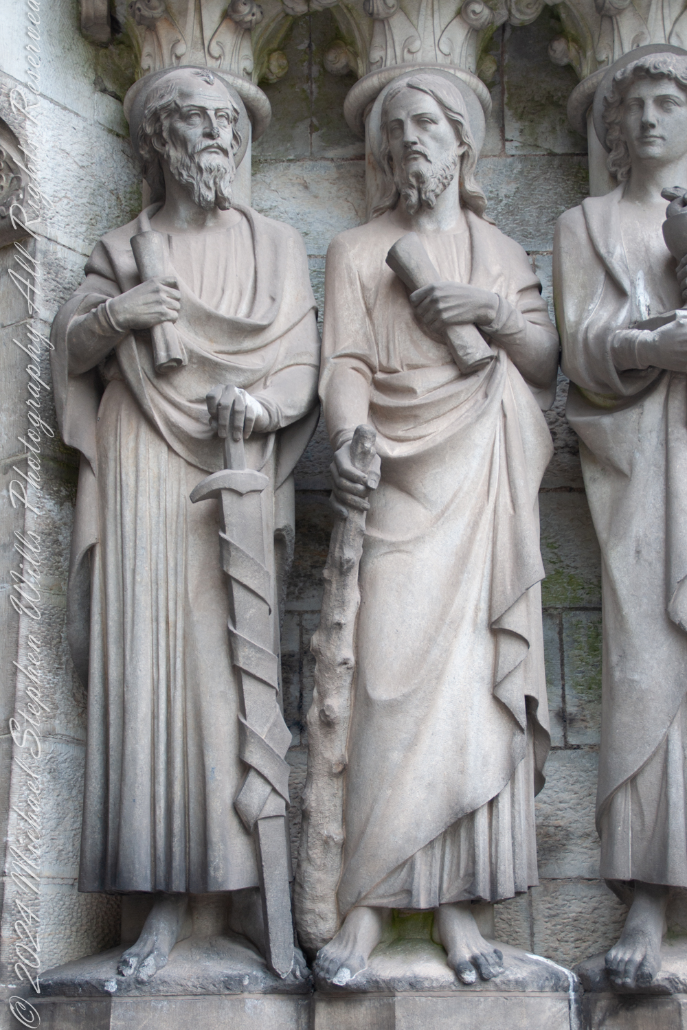
The cathedral’s external sculptures echo these individual representations of the apostles, where stone figures silently stand guard at the west entrance. The central figure of my photograph, holding a scroll in his left hand and a long cudgel (club) in his right, is Saint James the Less (also known as James the Minor). The scroll symbolizes his role spreading the word of God. The cudgel alludes to his martyrdom, as tradition holds that his executioners brutally beat him to death with such a club. His serene expression contrasts with Saint Paul, on the left, who holds the traditional “sword of the spirit” of his Epistle to the Ephesians. These carvings are spiritual sentinels, inviting visitors to contemplate the legacy of those who laid the foundations of the Church.
As the patron saint of the city, Saint Fin Barre’s enduring legacy profoundly impacts Cork’s spiritual and cultural history. His legacy dates back to the 7th century when he established a monastic settlement on the site where the cathedral now stands. This sacred location has witnessed centuries of devotion, destruction, and renewal. The visionary architect William Burges designed the cathedral in the 19th century as both a tribute to Saint Fin Barre’s enduring influence and a testament to William Burges’s own artistic genius.
Walking through the cathedral, I felt the interplay of past and present, earth and heaven. These saints and apostles are figures from history, embodiments of virtues and struggles that are timeless. Their stories invite us to reflect on our own faith, perseverance, and the ways we leave our mark on the world.
Saint Fin Barre’s Cathedral is a place of worship and a narrative in stone, wood, and glass. The intricate carvings and the evocative sculptures, among much else, create a space that transcends the ordinary. Here, the saints and apostles stand as eternal witnesses to the human journey toward the divine. As I left the cathedral, the image of Saint Paul, resolute and unyielding, stayed with me—a reminder that we must build faith, much like the cathedral itself, stone by stone, moment by moment, to endure the test of time.
Enter your email to receive notification of future postings. I will not sell or share your email address.
Copyright 2024 All Rights Reserved Michael Stephen Wills
Saint Fin Barre’s Cathedral features stunning Victorian Gothic artistry, with symbolic ceilings and intricate designs reflecting divine themes and craftsmanship.
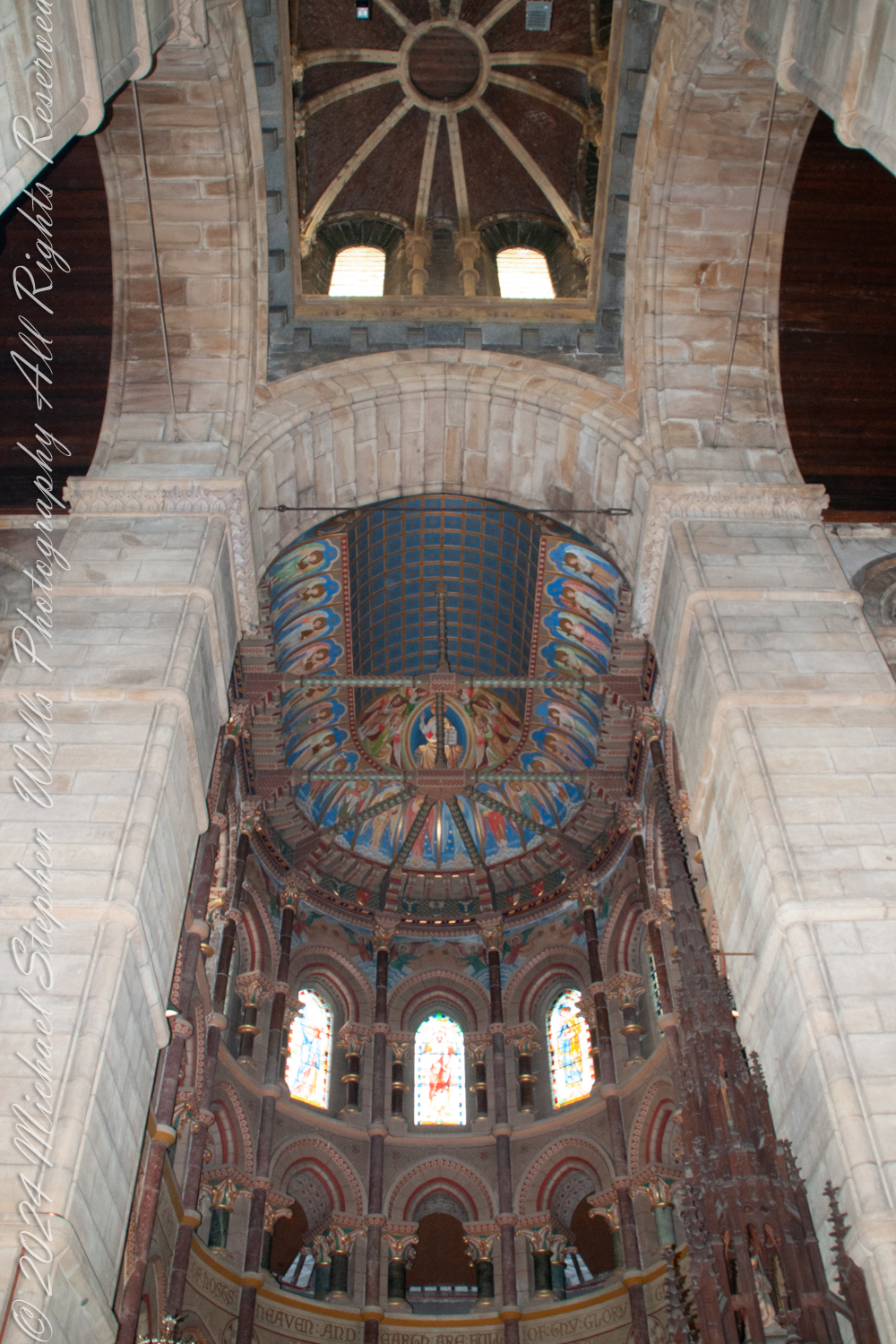
As I stood on the floor of Saint Fin Barre’s Cathedral in Cork, Ireland, I gazed upward toward the Apse and sanctuary ceiling at the eastern end. Turning my eyes directly to the west, I found myself captivated by the crossing ceiling—the very heart where the nave intersects with the transepts, forming the iconic cross shape typical of Gothic cathedral architecture.
In my imagination the central tower and spire soared majestically above the crossing ceiling. The ceiling there featured intricate architectural elements like ribbed vaults and a lantern tower, allowing light to flood into the space below. This crossing served as a beautiful transitional space between the sanctuary and the main body of the cathedral, the nave.
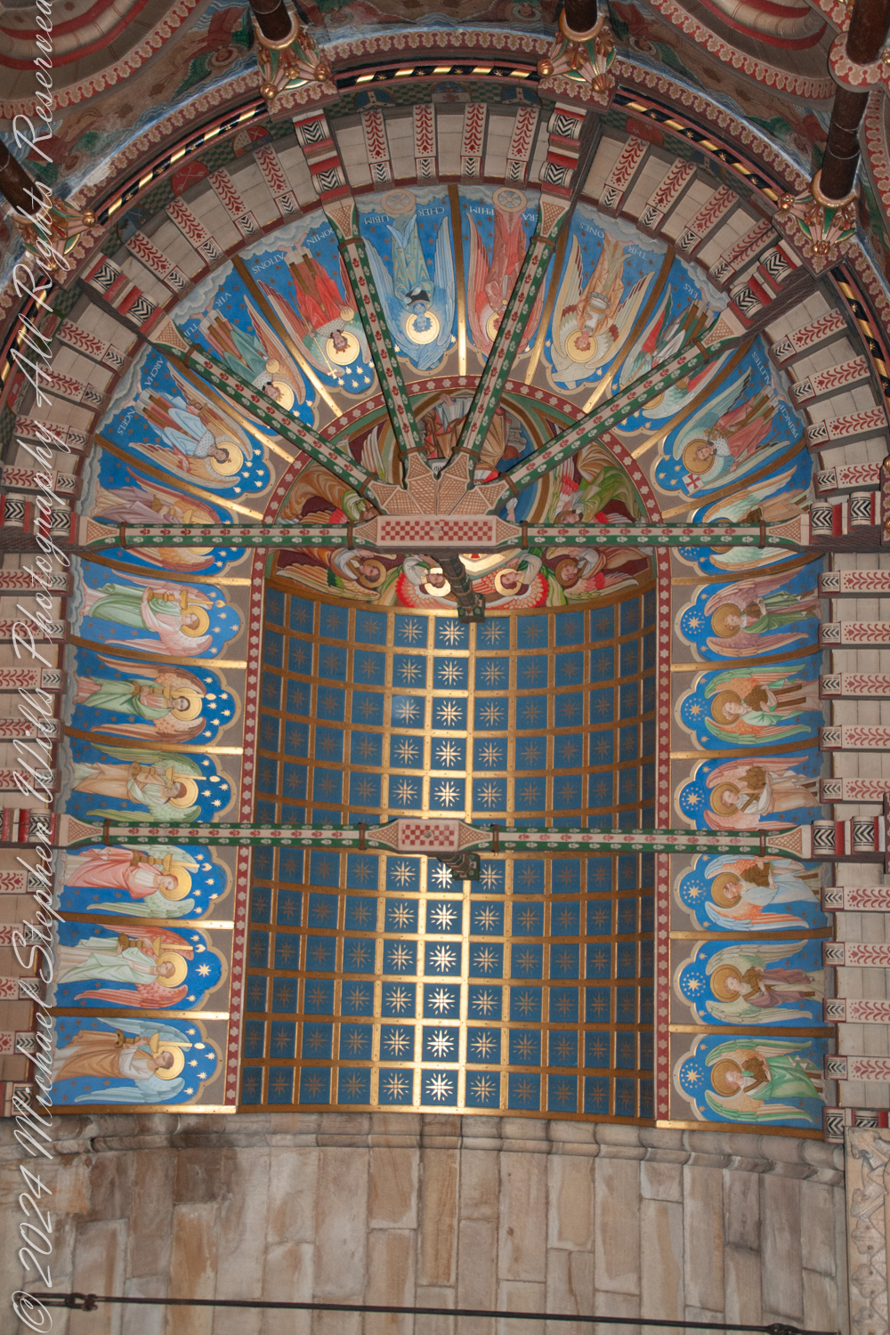
Focusing my camera on the Sanctuary Ceiling of Saint Fin Barre’s Cathedral, I was struck by the stunning example of Victorian Gothic Revival artistry before me. Designed by the architect William Burges, who envisioned every detail of the cathedral, the ceiling reflected his meticulous attention to detail and his love for vibrant colors and symbolic ornamentation.
The rich iconography drew me in. Angels adorned the ceiling, likely representing the celestial hierarchy or the glorification of Christ. Each angel held symbolic items—trumpets, stars, or scrolls—emphasizing their roles as messengers and worshippers of God.
The radiant color scheme was breathtaking. Deep blues, shimmering golds, lush greens, and vivid reds combined to create a striking visual effect, symbolizing heaven and divine majesty. Gold accents caught and reflected the light, reinforcing the idea of heavenly glory.
Geometric and star patterns embellished the vaults. The blue panels dotted with gold stars symbolized the heavens—a common motif in Gothic church ceilings. These stars seemed to represent divine guidance or eternity, adding another layer of meaning to the already rich tapestry above me.
The structural elements themselves were works of art. Painted ribs intersected across the ceiling, highlighting the Gothic architecture’s ribbed vaulting. Their intricate designs in green and red emphasized both structural beauty and functional elegance.
The symbolism was profound. The angels with their instruments and the starry heavens collectively evoked themes of divine worship and the glory of God’s kingdom. This alignment with the Victorian Gothic ideal of infusing spiritual symbolism into architectural elements was evident in every brushstroke.
Knowing that William Burges envisioned Saint Fin Barre’s Cathedral as a “Bible in stone,” I felt a deep connection to his purpose. Standing beneath the Sanctuary Ceiling—the focal point above the altar—I sensed how it served to elevate worshippers’ gaze and spirits toward the divine.
Capturing these scenes through my lens, I was documenting a testament to the artistic and architectural achievements of the 19th century. Saint Fin Barre’s Cathedral is a place of worship and also a living gallery of history, faith, and unparalleled craftsmanship.
Enter your email to receive notification of future postings. I will not sell or share your email address.
Copyright 2024 All Rights Reserved Michael Stephen Wills
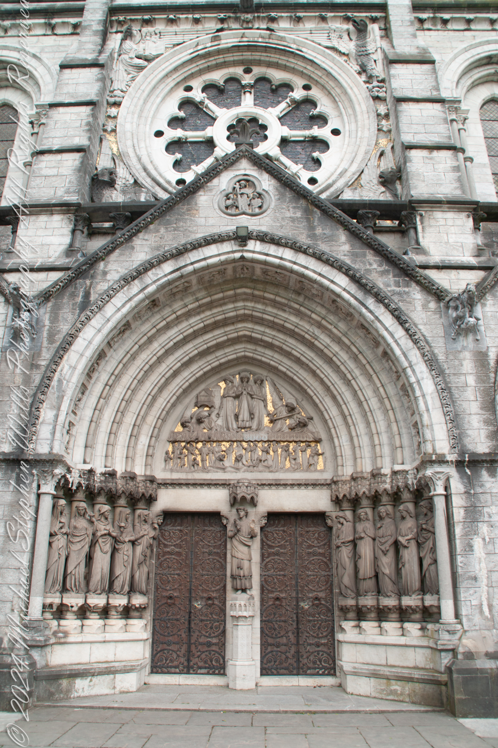
The towering Western Portico of Saint Fin Barre’s Cathedral leads into the sacred space of the church while serving as a canvas for a profound narrative of divine judgment and grace. Standing before it, I am drawn into its intricate details, particularly the central set of doors flanked by the ten virgins—five wise and five foolish—embodied in stunning columnar statues. Their story is drawn from the Gospel of Matthew (25:1–13), a parable of spiritual preparedness that echoes throughout the cathedral’s architecture.
The parable tells of ten virgins who go out to meet the bridegroom, each carrying a lamp. The wise virgins take oil with their lamps, while the foolish take none. When the bridegroom is delayed, all ten fall asleep. At midnight, the cry rings out, “Here is the bridegroom! Come out to meet him!” The virgins awaken and trim their lamps. The foolish ones, realizing their lamps are going out, plead with the wise to share their oil, but the wise refuse, saying, “There may not be enough for both us and you. Instead, go to those who sell oil and buy some for yourselves.” While the foolish virgins are away buying oil, the bridegroom arrives, and the wise virgins go with him into the wedding banquet. The door is shut. Later, the foolish virgins return, crying, “Lord, Lord, open the door for us!” But he replies, “Truly I tell you, I do not know you.” The parable concludes with the warning: “Therefore, keep watch, because you do not know the day or the hour.”
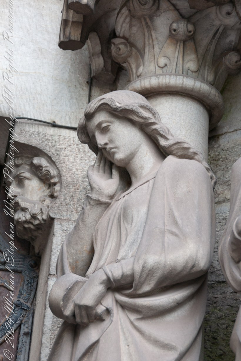
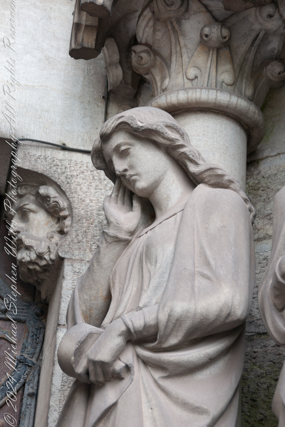
On either side of the central door, the virgins stand as sentinels, embodying this story. The wise virgins, to the right of Christ, hold their lamps aloft, flames burning brightly, symbols of readiness and spiritual vigilance. Their faces are serene, reflecting a sense of fulfillment in their preparedness to meet the bridegroom. To the left, the foolish virgins clutch their unlit lamps, their postures and expressions marked by despair and regret. The detail in their sculpting is exquisite—draped garments, forlorn gazes, and, in the case of the leftmost virgin, a subtle gesture of mourning, her hand resting thoughtfully against her cheek as though lamenting her unpreparedness.
Beneath each figure lies a pedestal adorned with imagery that amplifies their symbolic meaning. The wise virgins stand upon a foundation of flourishing life: vines, flowers, and fruits, evoking the vitality and promise of spiritual readiness. In contrast, the pedestals of the foolish virgins are carved with desolation—withered branches, skeletal forms, and motifs of death, stark reminders of the spiritual decay brought by neglect and complacency.
At the heart of the narrative stands Christ, the Bridegroom. His figure, commanding yet compassionate, turns toward the wise virgins, his gesture one of welcome and blessing. The flowing robes and the serene expression of the Christ figure emphasize his dual roles as judge and redeemer. It is a moment of movement captured in stone—Christ leaning into the wise while his back turns on the foolish, a subtle yet striking commentary on divine justice.
Above the door, the tympanum deepens this narrative, depicting the ultimate moment of judgment. Surmounted by three angels announcing the resurrection, their imagery and gold background harking to the Resurrection Angel of the east cathedral side with gold a symbol of purity and divine light; the dead rise from their graves, their fates determined by their spiritual choices. On the right, angels extend their hands to the faithful, pulling them upward toward eternal life. Their forms radiate lightness, their wings creating a sense of ascension and joy. On the left, the scene is markedly darker: angels, stern and unyielding, drive the condemned downward, their bodies twisted in expressions of agony. Flames lick at the edges of the scene, signaling the fires of damnation.
The weight of this imagery is palpable. The parable of the ten virgins, brought to life in stone, underscores the centrality of vigilance and readiness in the Christian faith. The Western Portico is a story carved in stone, a vivid testament to the choices each person must make. Standing before it, I am not merely a viewer but a participant, invited to reflect on my own readiness and my place in this cosmic drama. The intricacy and theological depth of this space leave an indelible impression, a reminder of the eternal truths that the cathedral seeks to communicate through its art.
Enter your email to receive notification of future postings. I will not sell or share your email address.
Copyright 2024 All Rights Reserved Michael Stephen Wills
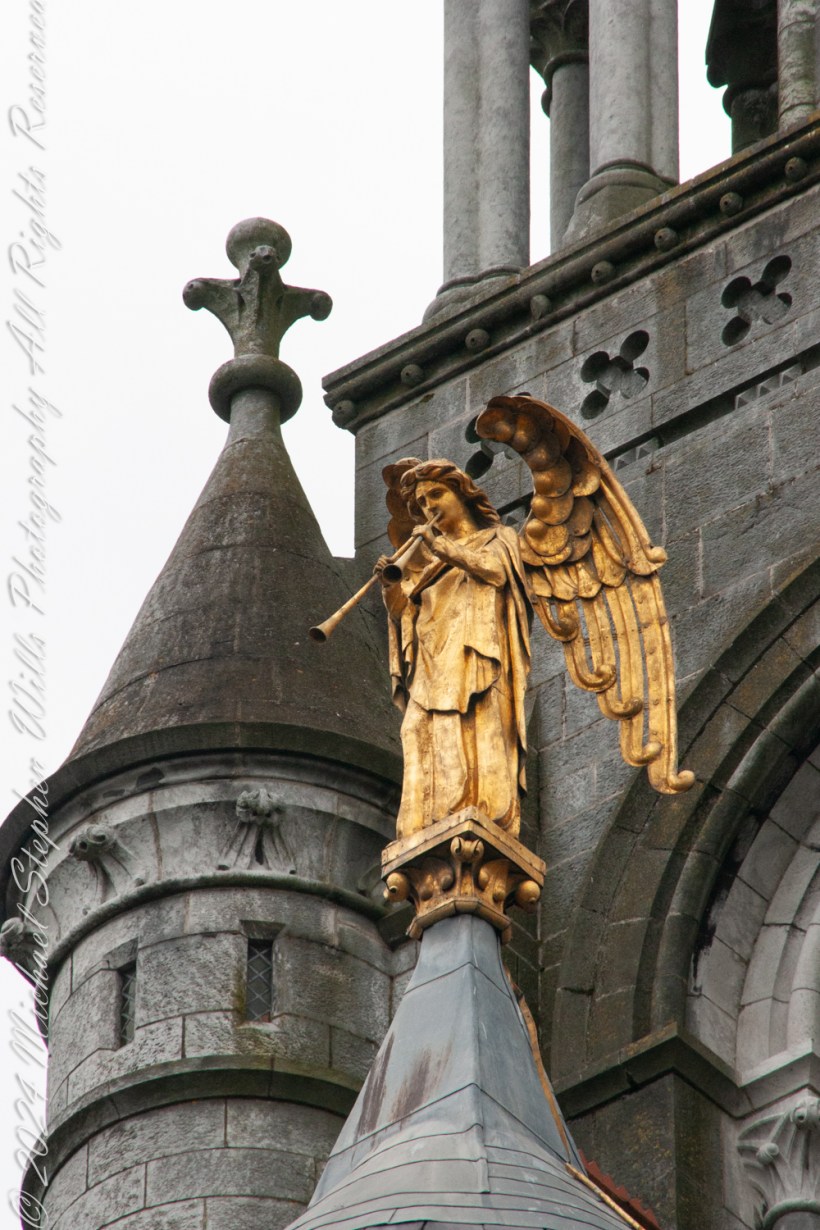
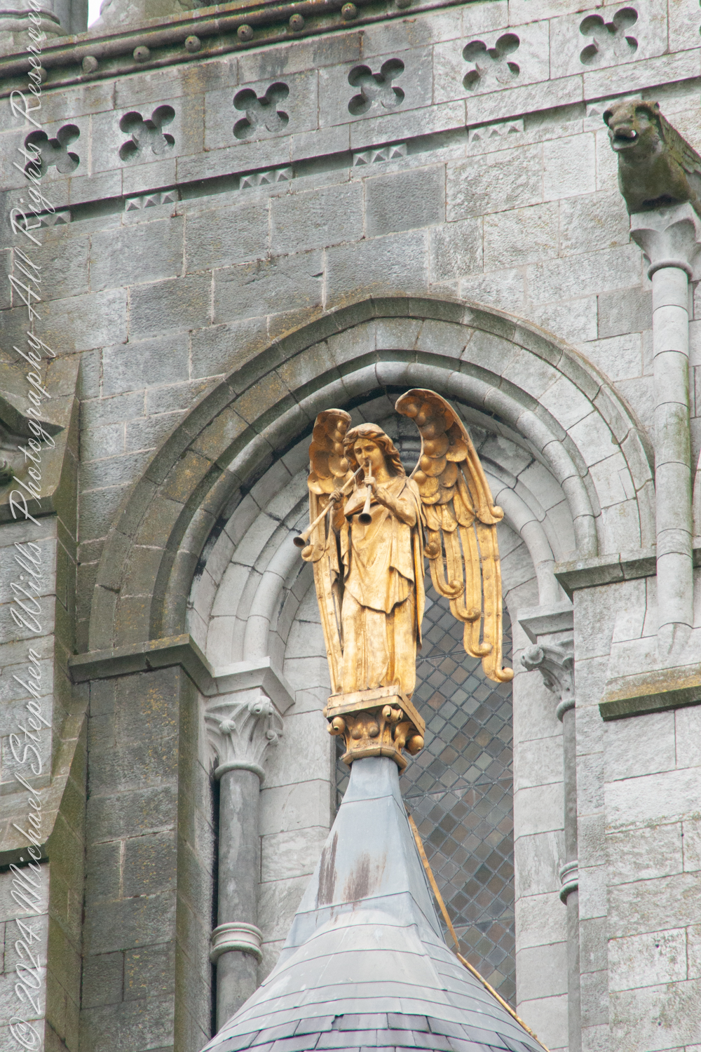
Standing on the east side of Saint Fin Barre’s Cathedral, I lift my gaze to the gilded angel high above the polygonal apse. Known as “The Resurrection Angel,” this radiant figure with its trumpet held aloft commands both awe and contemplation. As an enduring symbol of hope, renewal, and spiritual vigilance this angel carries a profound and dramatic promise: the sound of its trumpet will one day warn the people of Cork of the world’s imminent end, giving them the opportunity to be among the first to ascend to heaven.
The Resurrection Angel’s trumpet echoes the apocalyptic imagery of the Book of Revelation, particularly Revelation 11:15, where the seventh trumpet announces, “The kingdoms of this world have become the kingdoms of our Lord.” Yet in Cork, this celestial figure is imbued with a uniquely local significance. It stands as both guardian and guide, poised to fulfill its divine purpose when the end of days draws near. The legend elevates the angel’s presence beyond theology or art—it becomes a tangible connection between the celestial and the earthly, rooted in the lives of Cork’s citizens.
From an epistemological perspective, the Resurrection Angel poses fascinating questions about how we prepare for the unknown. What does it mean to live in the shadow of an angelic trumpet, one that might sound at any moment? Its silence is a paradox, a quiet yet profound proclamation of life’s transience. The legend suggests that the people of Cork, by virtue of the angel’s warning, are uniquely favored—a notion that intertwines faith with identity and imbues the city with a sense of divine guardianship.
The angel’s golden form shines brightly against the gray stone of the cathedral, a deliberate contrast that speaks to its otherworldly purpose. Gold, a symbol of purity and divine light, captures the eternal amid the temporal. The Resurrection Angel reflects the ambitions of the cathedral’s architect, William Burges, who intended every detail of Saint Fin Barre’s to serve as a testament to faith and artistry. This angel was the final piece installed, marking the cathedral’s completion and fulfilling Burges’ vision of a “perfect work.” According to lore, Burges himself declared that if the angel were ever to fall, it would signal the end of the world—a statement that deepens the mystique surrounding this celestial figure.
For Cork, the angel embodies the city’s resilience and collective spirit. Over centuries, Cork has weathered fires, floods, and rebellion, yet it has always risen anew. The angel, with its legend of warning and redemption, mirrors this cyclical journey of challenge and renewal. Its trumpet, silent but ever-present, reminds the people of Cork to stay vigilant, to hope, and to strive for goodness in the time they have.
As I stand beneath its watchful gaze, I feel the weight of the legend and its implications. If the angel’s trumpet were to sound today, would we be ready? It invites not fear but reflection—a challenge to live with purpose and awareness of the sacred in the everyday. And as I step away, the angel remains, steadfast and golden, a silent guardian over Cork, holding its promise and its warning aloft for generations to come.
Enter your email to receive notification of future postings. I will not sell or share your email address.
Copyright 2024 All Rights Reserved Michael Stephen Wills
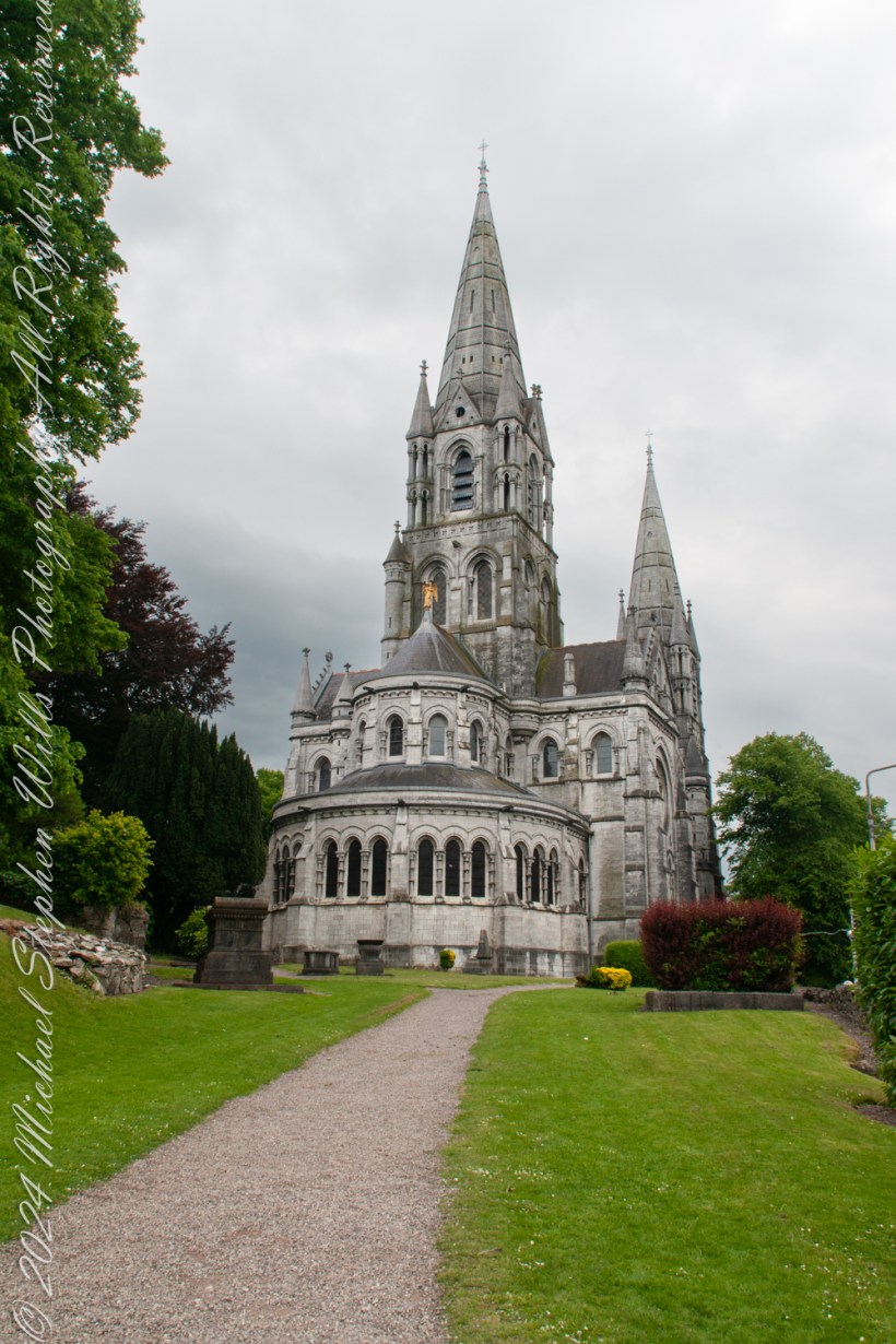
Approaching from the east, we see the polygonal apse at the eastern end houses the high altar and is a key liturgical and architectural feature. Each angular bay is delineated with tall lancet windows filled with stained glass, adding to the richness of the design. Saint Fin Barre’s Cathedral, a masterpiece of Gothic Revival architecture, stands as a beacon of faith and artistry in the heart of Cork, Ireland. Designed by the renowned Victorian architect William Burges, the cathedral is both a testament to the spiritual fervor of its time and a bold statement of artistic vision.
Approaching from the east, we see the polygonal apse at the eastern end houses the high altar and is a key liturgical and architectural feature
Commissioned in 1862, the cathedral replaced an earlier structure, marking a new chapter in Cork’s ecclesiastical history. William Burges, known for his theatrical approach to design, was the perfect choice for this ambitious project. His vision for Saint Fin Barre’s Cathedral blended medieval inspiration with Victorian ingenuity, creating a building that is as much a work of art as a place of worship.
Burges, a figure of eccentric brilliance, was deeply influenced by the principles of the Gothic Revival movement, which sought to recapture the grandeur of medieval European architecture. Drawing from this aesthetic, he designed the cathedral with meticulous attention to detail. Its three spires dominate the Cork skyline, with the central spire rising to an impressive height of 73 meters. These spires are not merely structural; they are symbolic, reaching heavenward in a gesture of devotion.
The exterior of the cathedral, constructed from Cork limestone and Bath stone, is adorned with intricate carvings and sculptures. These include depictions of biblical scenes, saints, and gargoyles, all painstakingly crafted under Burges’s watchful eye. Every detail reflects his belief that architecture should educate as well as inspire. Bishop Street, The Lough, Cork City, County Cork, Ireland
Enter your email to receive notification of future postings. I will not sell or share your email address.
Copyright 2024 All Rights Reserved Michael Stephen Wills
To continue my posting “Climb Hill of Tara” my first submission of three Hill of Tara photographs to Getty Istock had two of the photographs returned for revision.
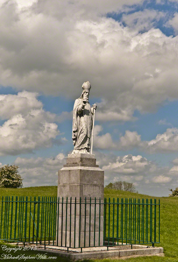
A statue of Saint Patrick fittingly welcomes visitors to the Hill of Tara, County Meath, Ireland. This statue of cast concrete was an existing statue donated by the Sisters of Charity, moved from an existing installation to the Hill of Tara in the year 2000 AD. The creator is anonymous, the is no plaque or other attribution on or around the statue.
The original statue was erected on the summit of the Hill of Tara shortly after Catholic emancipation in 1829, commemorated the events of 433AD when St. Patrick lit a bonfire on the nearby hill of Slane on the eve of Easter Sunday.
Lighting such a fire was contrary to the pagan laws of the time which dictated that the first fire lit that night be in Tara. Observing St. Patrick’s bonfire from afar, the chief druid of the ancient Gaelic capital predicted that if the flame were not extinguished that night, Christianity would never be extinguished in Ireland. The saint’s bonfire continued burning and the next morning, Easter Sunday, St. Patrick entered Tara to convert the king and his followers to Christianity.
For the fenced statue of Saint Patrick the revieweR wrote:
Please provide a full description for the work of art featured in this image. Include the artist, date of creation, location, etc. Works of art created by someone other than yourself must be free of copyright protection to be considered. If this work of art is indeed under copyright protection, a property release signed by the copyright holder will need to be provided.
Hmmmm….What I do while capturing a photograph of a statue is take photos of any plaque, sign, whatever to acquire the name of the creator, how it came to be there, community connections. There was nothing around the statue nor the very informative Office of Public Works placards at the entrance. I was proud to submit the statue photograph, as it turned out so well, and hoped for the best.
Last week, I put in a query to Ireland’s Office of Public Works (OPW), the agency responsible for the Hill of Tara, and did not receive a response when, for other queries, they were helpful. This Saturday and Monday mornings, several hours of internet research revealed this history.
The original statue was placed on Tara sometime after the 1829 Catholic emancipation. It was molded concrete, created by Thomas Curry of Navan at his own expense to honor the connection of Saint Patrick to Tara.
The OPW removed Curry’s statue 1992 for repair of a century of wear. During the removal the statue was damaged beyond repair and, afterwards, was further damaged by vandals who decapitated and used it for target practice.
Initially, the OWP decided not to replace Saint Patrick citing the “pagan” nature of the place. After an angry meeting of local people at the Skryne Parish Hall. In this meeting the local Rathfeigh Historical Society formed the “Committee to Restore St. Patrick to Tara.” In turn, pressure was put on Michael D. Higgins, Minister for Arts, Culture and the Gaeltacht (and the OPW). It was decided a new statue was to be created, based on a competition, and instead of it former place at the hill summit (called Rath na Rí), it was to be near the entrance, outside the Interpretative Center, to offer a Céad Míle Fáilte to visitors and be seen on departure.
The outcome was the competition winner was rejected by locals. The winning entry, by sculptor Annette Hennessy, did not follow competition rules that specified the statue incorporate traditional features to include shamrocks, harp, miter, a crozier and, perhaps, fleeing snakes. Hennessy’s design was of a shaven headed teenage boy in a short (“mini-skirt”) kilt, a handbag-shaped bell in hand. She agreed hers was “not a traditional style statue” saying it “acknowledges our Pagan Celtic history.”
The rejection included a statement from Dr. Leo Curran, chairman of the Rathfeigh Historical Society, “We agreed that most of the monuments in Tara are from the pre-Christian era, but St. Patrick should be at the uppermost layer, representing Christian tradition extinguishing paganism.”
By this time, a new government and minister were in place. The decision was made to search Ireland to find a suitable, existing, replacement statue. By 2000 the present statue, donated by the Sisters of Charity, was in place at the Hill of Tara entrance.
At the end of this post I provide the two references from my internet research and from which many facts and all the quotes were used here. I concluded the statue author was anonymous without copyright protection and submitted a revised image description, attaching a copy of my research.
What happened to my IStock photograph of Saint Patrick on the Hill of Tara? Getty accepted my application, published the photo and it is one of my top downloads, and earners.
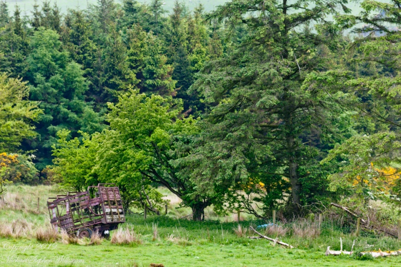
In the early dawn, I walked the path to Killen, drawn by the legacy of my mother’s Irish youth. An abandoned hay wagon stood, a relic amidst the whispers of history and myth. Join me in uncovering the roots that intertwine family and the enduring Irish land.