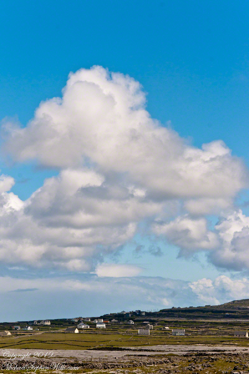
Standing atop the cliffs of Dún Aonghasa on Inis Mór (Inishmore), one is struck by contradiction. Beneath your feet lies a landscape of exposed limestone, fractured and weathered into the unmistakable geometry of karst. These unworked, barren slopes have a pale green covering growing seemingly on air. The Atlantic crashes hundreds of feet below, while inland the island stretches toward Galway Bay in shades of gray and pale green. It seems an improbable place for agriculture.
Yet there they are: fields enclosed by dry stone walls, dotted with cattle and thick enough with grass to sustain them. Looking out across this island, a question naturally arises. Where did the soil come from?
The answer is simple to describe and astonishing to contemplate. The soil of Inis Mór was, in large measure, made by human hands.
The Aran Islands are composed primarily of limestone deposited some 350 million years ago when this part of the world lay beneath warm tropical seas. The shells and skeletal remains of ancient marine organisms accumulated on the seabed and, through immense pressure and time, became stone. Today, limestone accounts for the overwhelming majority of the islands’ bedrock.
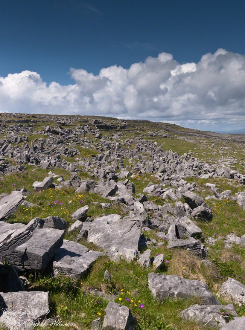
Limestone landscapes possess a severe beauty. Rainwater, slightly acidic from dissolved carbon dioxide, which in turn slowly dissolves the rock, creating fissures known as grykes separated by flat blocks called clints. Soil drains rapidly through these cracks. Left to natural processes alone, only thin accumulations of organic material develop and much of the landscape will resemble a stony pavement.
For generations, survival on Inis Mór required transforming that pavement into productive land.
Islanders gathered seaweed from the shoreline, hauling it inland by cart and hand. The seaweed provided organic matter and nutrients, particularly potassium and trace minerals. Sand from the beaches added texture and volume. Mixed together atop the limestone surface, these materials slowly decomposed into something capable of supporting plant life. Over decades—and in some places centuries—layers accumulated.
The process demanded persistence. Storms could strip away exposed earth. Atlantic winds threatened erosion. Each year required renewal: more seaweed, more organic matter, more labor. Roots from grasses and crops helped bind the developing soil together. Animal manure returned nutrients to the ground. What had begun as an artificial growing medium gradually became a living soil ecosystem.
As understood by modern soil science, soil formation is often explained through five factors: climate, organisms, relief, parent material, and time. On Inis Mór, all five are present, but there is a sixth factor impossible to ignore: culture.
Without human intervention, much of the island would likely remain dominated by exposed limestone and sparse vegetation. Instead, generations of residents imposed patience upon geology. Their work transformed an inhospitable environment into a functioning agricultural landscape.
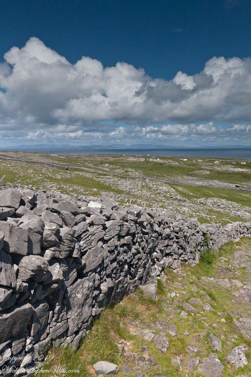
The dry stone walls that divide the island tell the same story. Built from limestone cleared from the fields, they required no mortar. Each stone was carefully selected and placed, creating boundaries that controlled livestock, sheltered plants from relentless winds, and marked family holdings. The walls themselves became part of the ecological fabric, providing habitat for insects, mosses, lichens, and wildflowers.
Visitors often admire these walls for their picturesque quality. They are indeed beautiful and are also evidence of necessity. Every stone removed from a field made space for soil to deepen and grasses to spread. The very act of creating pasture simultaneously generated the material for the island’s defining architecture.
There is poetry in this relationship between hardship and abundance.
In many places, fertile soil is taken for granted. Deep glacial deposits or river sediments create agricultural wealth with little awareness of the thousands of years involved in their formation. On Inis Mór, however, the origins of fertility remain visible. The limestone still protrudes through the fields. The seaweed-strewn shore lies only a short distance away. The walls reveal the labor embedded in the land.
To walk these fields is to encounter a collaboration between people and place extending across centuries. The islanders did not conquer the landscape so much as negotiate with it. They worked within its constraints, borrowing from the sea to enrich the stone and relying upon time to complete what effort had begun.
The resulting landscape offers a quiet lesson. Soil, the foundation of civilization, is created through intricate interactions among rock, water, organisms, and time. On Inis Mór, soil also represents inheritance: the accumulated labor of countless individuals who refused to accept barrenness as destiny.
Viewed from the heights of Dún Aonghasa, the green fields scattered across the gray limestone are miraculous.
Not a miracle of sudden transformation, but one measured in generations—made from seaweed and sand, from patience and persistence, and from the enduring belief that even the most unpromising ground can, with enough care, be coaxed into life.
The answer is simple hard work, hundreds, a thousand years of hauling seaweed and sand, mixing it on the barren limestone, allowing the rot of time to work. Hold it down with roots, till and refresh.
A span of 10,000 years spreads between now and the first possibility of settlement on the island of Eire, then swept clean to bare rock by the weight of ice. Current scholarship of the Dún Aonghasa ruins, Inishmore, County Galway, the Irish Republic place a settlement within the inner of the four dry stone rings after 6,500 years (1,500 BC or 3,500 years ago). By way of scale, the first settlement took about 30 times the duration of the U.S. Constitution ratification through 2025: the last state, Rhode Island, ratified the Constitution 1789.
By 700 BC, 2,700 years ago, a series of upright, closely placed stones, were erected between the second and third rings called a cheval de fries field (“Frisian horses” in English) today, this defensive structure evokes the enormous scale of the struggles around this place of defense.
This is a portion of that field, I believe, taken as Pam and I approach the inner ring entrance, walking a wide path cleared of barriers. Click the photograph for a larger image with caption.
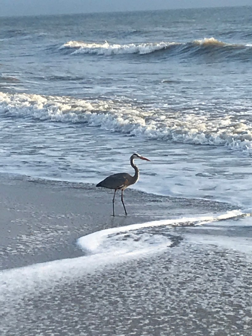
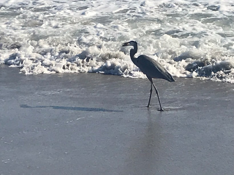
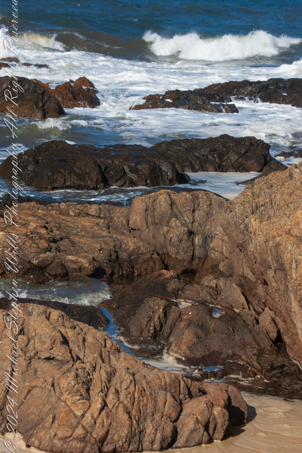
Along the luminous seam of surf and sand, a heron reads the tide’s slow grammar, patience embodied, until water yields a silver secret and morning becomes ceremony.
We walk the long seam where the Atlantic writes its restless script, and our beachcombing becomes a study in attention. The shore’s edge—where foam loosens shells from sand and the wind arranges salt on the tongue—draws other walkers too: grey herons, patient and arrow-straight, patrolling the surf line as if reading a language older than tides. They halt us without trying. We stand, quieted, while they work the boundary between water and land, between hunger and satisfaction.
I pack an iPhone sometimes for beachcombing as a lightweight alternative to SLRs. This post features iPhone photographs.
Along this narrow world of sand and surf, herons keep two distinct manners. Some linger near anglers, learning the thrift of handouts and the craft of appearing inevitable. Others refuse that bargain and hunt on their own, staking the wash with a slowness that is not delay but method. These independent operators move along the ocean’s margin: high enough to let the breakers fold ahead of them, low enough that their long legs stir the small lives hidden in the cross-hatching currents. To follow one with the eye is to adopt a different clock. Sandpipers skitter and dash; the heron lengthens time.
A perfect place to stalk the surf
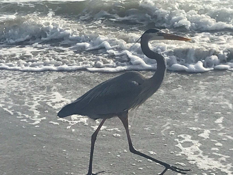
At first the bird seems merely spellbound by light on water. Then a shift: a narrow cant of the head, the smallest realignment of the eye to the glare. The neck—serpentine and stored with intention—uncoils quick as a strike, and the bill cleaves the surface. The world either yields or it doesn’t. Often it doesn’t. When it does, the beak lifts an impossibly large, glinting fish, as if the ocean had lent out a secret.
Success!!
What follows is ceremony. The heron stands and calibrates, turning the silver length with almost invisible nods until head and prize agree. A sharp jerk aligns the fish with beak and gullet; the upper throat swells, accepting the whole, unchewed. Two more pulses and the catch is a memory traveling inward. It is an astonishment every time, not because we do not understand what is happening but because we do, and still it exceeds us.
We carry a smart phone on these morning circuits, a slim stand-in for heavier glass, enough to witness without intruding. Backlit by the early sun, the herons are cut from bronze and shadow, working the luminous edge while the day composes itself behind them. In the afternoons we meet fewer of the solitary hunters when the strand belongs more to the opportunists near the thinning knots of anglers. Why the shift, we cannot say. The ocean has its schedule; so, it seems, do its readers.
If we keep our distance, we are permitted to watch. Cross a line we don’t perceive and the bird will rise all at once, the long body unfolding, the voice a rasping scold torn from the throat of reed beds and marsh dawns; but, grant it enough space, and the heron returns us to the lesson it keeps teaching: that patience is a kind of movement; that the boundary of things is where change is clearest; that the most astonishing acts require the courage to do very little, very well, for a long time.
We come to linger where the waves erase our tracks, apprenticed to that slow grammar, trying to learn the tide’s careful verbs before the light turns and the day becomes something else—a different text, the same shore, the heron already a thin signature against the horizon.
Enter your email to receive notification of future postings. I will not sell or share your email address.
Copyright 2025 All Rights Reserved Michael Stephen Wills
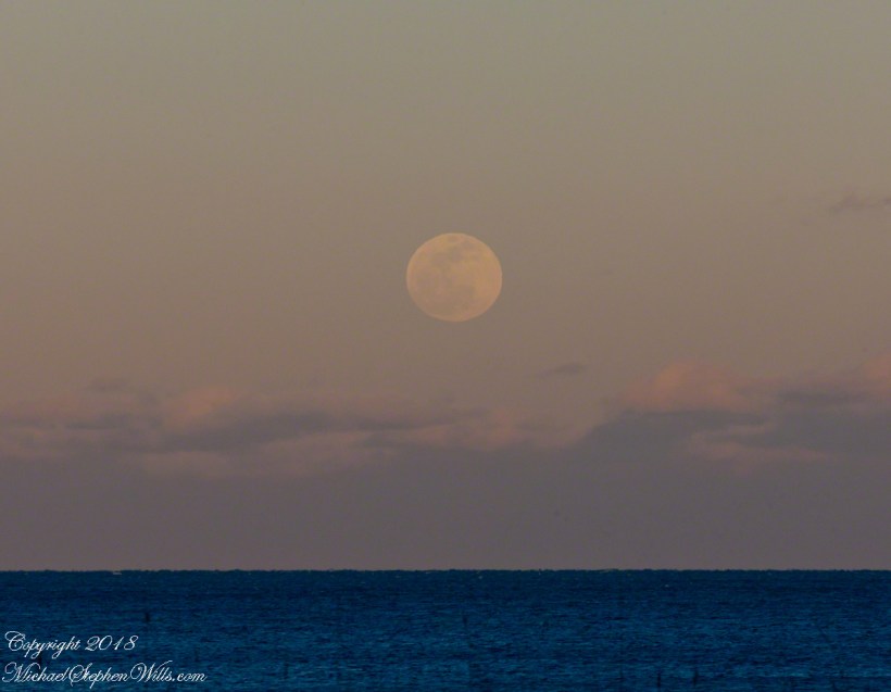
On certain evenings we gather on our Cocoa Beach, Florida east-facing beach-side balcony simply to watch the day undo itself—sunset staining the western sky while, behind us, something quieter begins. On Sunday, January 20, 2019, the quiet had a name: a total lunar eclipse. I’d checked the online charts earlier—moonrise time, azimuth, the patient geometry of the heavens laid out in numbers—and set our chairs faced the anticipated spectacle.
The light went a little pewter, as it does when the sun slides offstage and the world inhales. Out on the water a cruise ship shouldered south, a floating city of windows that, under ordinary sunsets, catch fire pane by pane. I looked up too late for the blaze and felt that small pang one gets for the thing almost seen. Still, the ship kept gliding, a bright punctuation mark traveling our skyline.
Then the moon appeared—first as a bruise-colored coin pressed against a bank of cloud, then as itself, pale and whole, rising as if pulled on a cord. Photographs can play a trick here: place a ship under a full moon and, with the right lens, the vessel swells to improbable grandeur while the moon looks like a modest ornament. Our eyes know better. The ship is huge but near; the moon is unimaginably larger, only far. Distance humbles everything.
It’s a fine parlor truth that every lunar eclipse requires a full moon. There’s a steadiness in that—that the earth, playing the rare importance of middle child, can only cast its shadow when the moon has come fully into its own. The reverse, of course, is not guaranteed. Most full moons rise and go about their business, silvering roofs and quieting dogs, without ever tasting the earth’s shadow. Tonight would be different.
The Riddle of Size
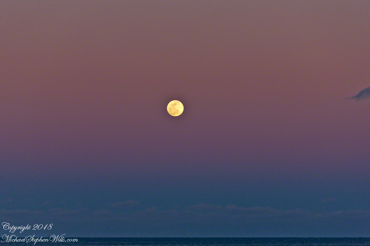
Before the darkness advanced, the old riddle of size made its entrance. Low on the horizon, the moon seemed suddenly intimate, big enough to pocket the ship and still have room for the lighthouse. We call it an illusion, but the word hardly captures the tenderness of it: how the mind, seeing that round face near our familiar trees and eaves, feels the moon to be part of our belongings. Angular diameter stays stubbornly constant; affection does not. The experiment is easy enough—choose a pebble that covers the low moon at arm’s length, then try again when the moon is high. The same pebble hides it perfectly. What changes is not the moon, but the story our senses tell.
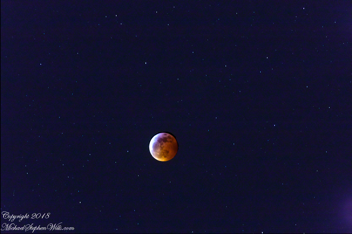
Clouds raveled and the disk lifted, gathering brightness. As the earth’s umbra slid across that worn, luminous stone, the color shifted from pearl to rust, then to the old red of clay amphorae. People love the names—Super, Wolf, Blood—as if the moon had stepped onto a carnival midway. I prefer the quieter facts: sun, earth, moon aligned; light refracted through air; the planet itself briefly confessed in velvet shadow. It felt less like spectacle than like a family resemblance revealed by candlelight.
Eclipse
Much later, around us, the little neighborhood chorus noticed. A conversation stalled mid-sentence; the unspooled hush you hear at a concert just before the bow draws its first note came and settled on the patio. Even the ocean seemed to restrain itself, waves taking smaller breaths. The cruise ship had long since slid behind the curvature of our seeing.
We kept watching. A lunar eclipse is an exercise in patience: everything happens slowly enough to be felt, quickly enough to refuse boredom. Shadows are honest about their edges. When the moon wore its deepest copper, I thought of ancient nights and imaginations unlit by anything but fire, how dependable cycles must have seemed like messages and how—standing there, spine pricked by a familiar old awe—I could not entirely disagree. It was not fear, but kinship: the sense that we are included in the machinery, not merely spectators.
When the light returned, it did so from one margin, like dawn rehearsed on a smaller stage. The coin brightened by degrees, and the old face we know reappeared—craters and mares soft as thumbprints. The illusion of size faded as the moon climbed, and the experiment with the pebble proved itself yet again. Even so, I felt the tug of that earlier enchantment, the way a child misses a dream just after waking. The mind keeps two ledgers: one for what is measured, one for what is felt. Tonight both were full.
Eventually we retired. Chairs nested. Doors clicked. In the kitchen, glasses chimed in the sink. But the moon kept on, white and durable, its borrowed light restored. Somewhere out there the ship’s passengers drifted to their cabins, stories in their pockets about the night the world itself cast a shadow, and how the ocean looked briefly like copper under a patient star.
Later, when I wrote down the times and the few facts I could trust to memory, I realized the real record was not the measurements but the company: our leaning back, the shared breath, the soft astonishment that comes when something vast moves at a human pace. The eclipse ended; the evening did not. That, too, felt like a kind of alignment—ours with one another, our small chairs with a very large sky.
Enter your email to receive notification of future postings. I will not sell or share your email address.
Copyright 2025 All Rights Reserved Michael Stephen Wills
From the commanding location of Dún Aonghasa, looking northeast across Inishmore, the logic of the ancients becomes clear. No better vantage could be found—land unfurling like a hand toward Galway Bay, cottages nestled in green folds, clouds billowing above like sails caught mid-journey. A place of presence. A place of permanence.
Perched high on the cliff’s edge, the fort behind, the Atlantic at the back, the wind carried stories—unwritten, unspoken, but felt in the bones. Below, stone walls divided the island into patterns of memory. Fields outlined in rock, laid long ago by hands familiar with hardship and patience. The sea’s pulse echoed faintly in the distance, as steady and unfathomable as time itself.
No words were needed in that moment. Just the hush of sky and stone. Cottages, bleached bright by limewash—kalsomine, the old name still whispered by some—stood resilient against the elements, each one a witness to generations. Each one seemed to carry a personal reverence, a tenderness carved into the landscape.
Paths led gently inland, where wind slowed and voices from distant homes rose faintly through the open air. Along those paths, the rhythm of island life could be read in hoof prints, scattered wool, and the sharp, clean edges of hand-cut stone. There, among the hedges of limestone and wild grass, the living and the lost felt close.
The cloud cover shifted constantly. Shadows passed like thoughts across the land. Toward the shore, the sky opened wide. A silence filled the lungs, as bracing and deep as the Atlantic itself. Time seemed to slow, the mind slipping into the rhythm of the land.
Limestone pavement, rough beneath the boots, told its own tale of erosion and survival. That the earth here could sustain even the most modest farming seemed improbable. Yet here it was: a testament to stubborn hope and quiet ingenuity. In that quiet, ancient energy rose—something older than the fort, older than language. A pulse shared with the rock and wind.
The fort eventually came back into view—perched as if grown from the cliff itself, curved walls enclosing nothing but air and sky. I perceived no defensive bluster, only presence. And what a view it commanded. On days like this, the clouds formed towering cathedrals overhead, white and gold in the sun. Below, the cottages and fields seemed miniature, perfect, enduring.
The wind played echoes of prayer, lullaby, and laughter mingled with the call of seabirds. The thought came that nothing here was ever truly lost—only layered. Generation upon generation, each leaving some trace: a stone placed just so, a wall mended one final time, a cottage roof patched for another winter.
Here, even the air speaks. It moves gently but insistently, brushing the cheeks and stirring something ancient within the chest. Beneath it, the island breathes: not loudly, not urgently, but with the slow, deep rhythm of the tides.
As the sun dipped slightly westward, light changed across the fields, cottages glowing warm against darkening green. The wind softened. The clouds drifted, still massive but no longer looming. Time to return. A glance back offered one last communion with sky, stone, and silence.
Inishmore, on that day had been absorbed. Understood not with the mind, but with something quieter. Something that listens without need for words.
It was the kind of overcast morning that seems to cradle the island in a blanket of mist, a gentle hush falling over the land as though even the Atlantic held its breath. Pam and I had arrived by ferry at Kilronan, the main settlement on Inishmore (Inis Mór), the largest of the Aran Islands nestled in Galway Bay. There, amid the bustle of arrivals and greetings, we found our driver—a wiry, weather-worn man with a soft brogue and kind eyes—and his horse trap, a simple two-wheeled carriage with room enough for three and the sounds of hooves to accompany our journey.
We set out up Cottage Road, the stone-paved track winding westward from the harbor. The sea fell away behind us as we climbed, a gray shimmer stretching to the hazy outline of Connemara’s mountains on the far side of the bay. Our destination was the dramatic cliffside ringfort of Dún Aonghasa, a place older than memory. But it was the unexpected moments in between—the ones not printed in guidebooks—that linger longest in the mind.
As we rounded a bend flanked by low stone walls, wildflowers blooming defiantly in the cracks, our driver pulled the reins gently and pointed with his crop.
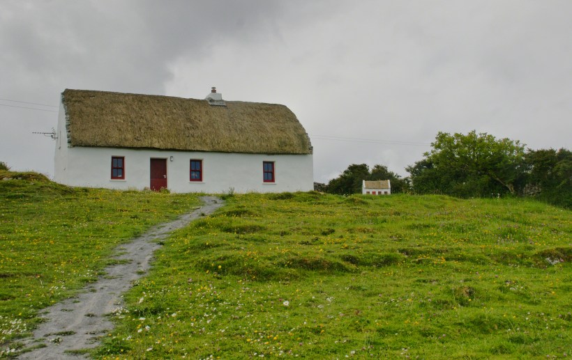
“There,” he said, nodding ahead, “is a fine example of a traditional Aran cottage.”
And there it was—a vision from another time. The thatched roof curved softly like a that blanket itself, straw golden against the brooding sky. The walls were whitewashed to a perfect matte sheen, gleaming in spite of the cloud cover. A crimson door and two window frames punctuated the front façade like punctuation in a poem. Just to its right, set further back on the hill, stood a tiny replica of the same cottage, identical in every feature. I blinked, half believing it was an illusion.
This thatched cottage with matching child’s playhouse is on Cottage Road out of Kilronan Village on the Aran island, Inishmore, County Galway, Ireland.
We only stopped briefly—it was a private residence—but the sight of it left a kind of imprint. I turned in the trap seat to keep it in view as long as I could. The cottage was perfectly placed, facing Galway Bay with a commanding view. I imagined the light pouring across the line of mountains, catching the glint of sea and sky.
“There’s a name for that finish,” I said, recalling something I’d read, “whitewash, or lime paint.”
Our driver nodded. “That’s the old way. Made from slaked lime. We’d call it ‘whitening’ when I was a lad.”
Whitewash differs from paint in the most elemental of ways. It becomes part of the stone, absorbed into the very surface. Like a memory of bone. And yet, it requires care. Apply it to a wall not properly cleaned or moistened, and it flakes, pulls away like a broken promise. But done right, it lasts, breathes with the building.
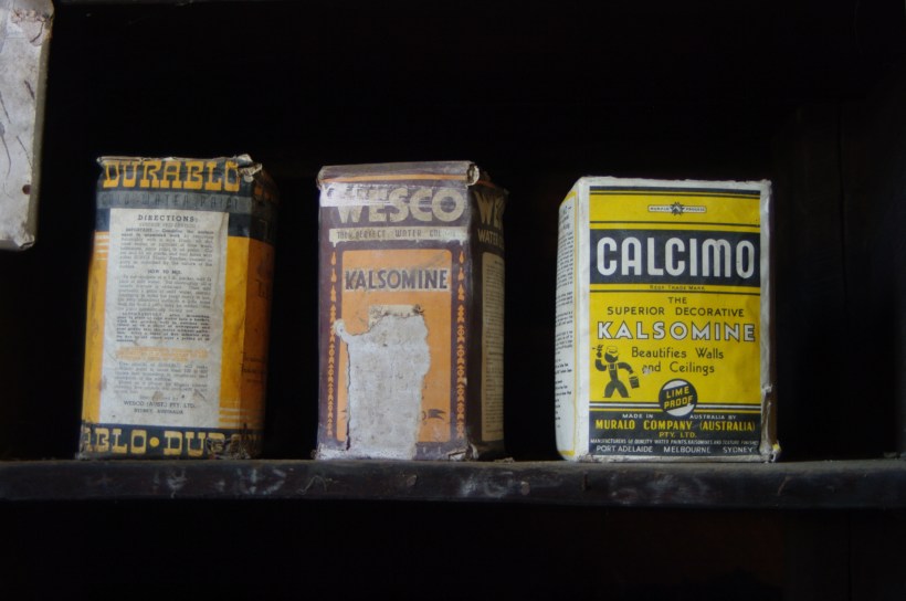
Upon our return, researching “whitewash,” if found this photograph from the Yarloop railway workshops Yarloop, Western Australia. There, on a shelf, where three old boxes sat like relics: DURABLO, WESCO, and CALCIMO. All contained kalsomine—the powdered form of lime paint. CALCIMO promised to “beautify walls and ceilings” and was proudly marked “LIME PROOF.” There was something quietly heroic in that. Lime-proof, as though against time itself.
Looking at the box of Calcimo, a product of the Murabo Company of Australia, I was struck by how far the tradition had traveled. From island cottages in the Atlantic to distant corners of the Southern Hemisphere, the language of whitewash—of simplicity and purity—had touched the world.
We returned by the same road, past that same cottage, the small one still keeping watch beside it like a child beside a parent. And I knew then that the islands hadn’t just given me sights—they had offered stories, silent ones written in thatch and stone, in lime and wind.
Sources for this post: search wikipedia for “White Wash”. White wash photo author: Wikipedia commons user Gnangarra
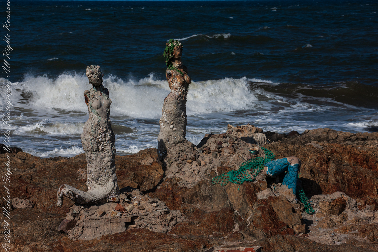
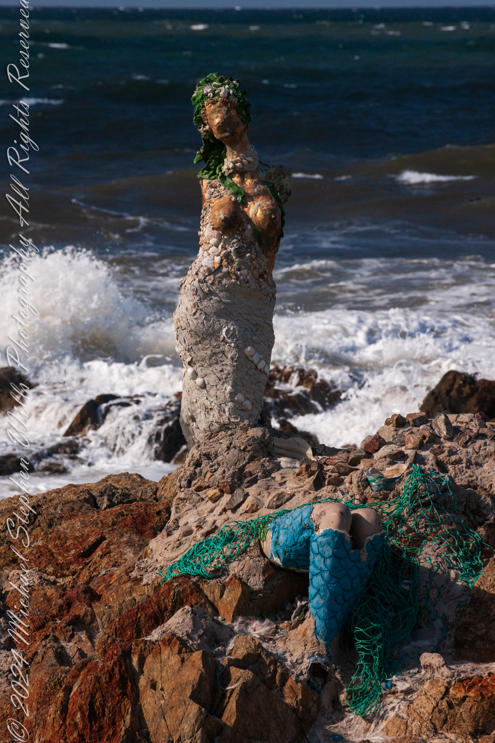
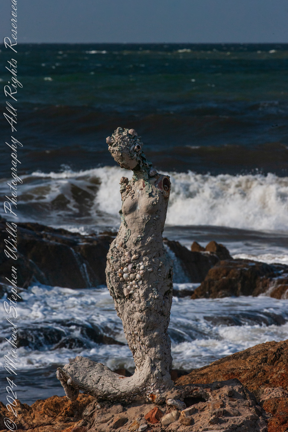
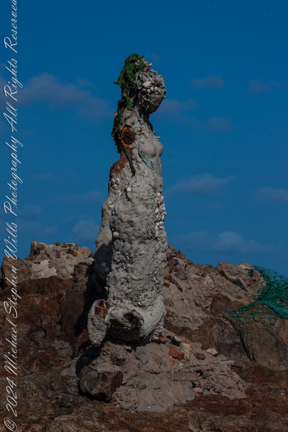
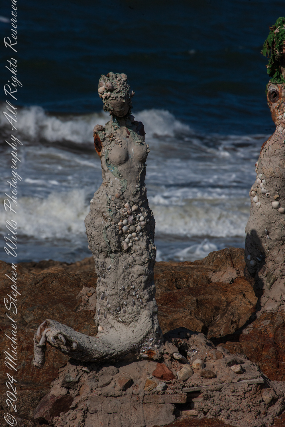
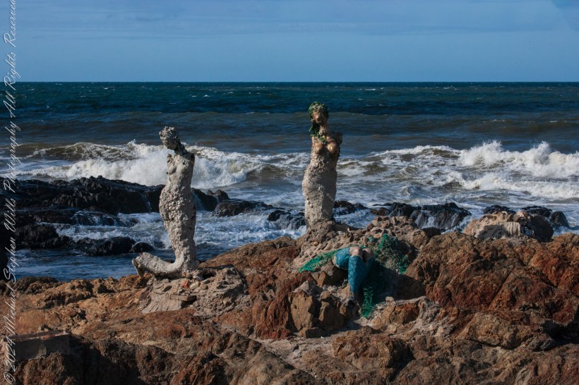
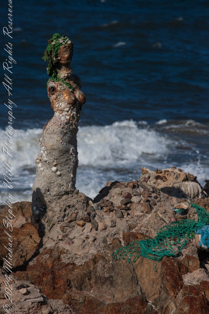
The wind carried the scent of the sea as we stood at Punta de las Salinas, the furthest tip of Punta del Este, Uruguay. This was a place of myth and mystery for us, where the Atlantic Ocean merged with the Río de la Plata, and where the rocks bore witness to the timeless interplay of water and stone. Here stood “El Canto de las Sirenas” (The Song of the Mermaids), an evocative art installation by Lily Perkins, first completed in 2012. The sculptures seemed perfectly at home here, their placement deeply intertwined with the mythology they evoked.
This is at Great Britain Square, Punta de las Salinas of Punta del Este. We are at the tip of the peninsula, the easternmost point of Uruguay. This is the art installation El Canto de las Sirenas” (The Song of the Mermaids) (2012) by the artist Lily Perkins. Punta del Este, Departamento de Maldonado, Uruguay
The sirens of ancient lore were said to dwell at perilous points where land met the untamed sea, luring sailors to their doom with haunting songs. These rocky outcrops, both a boundary and a threshold, have long held symbolic power as places where the natural world is at its most raw and elemental. Punta de las Salinas is such a place. Its jagged rocks and churning waves create an environment as beautiful as it is treacherous. It is easy to imagine mythical sirens choosing this very spot to weave their spellbinding melodies.
This is at Great Britain Square, Punta de las Salinas of Punta del Este. We are at the tip of the peninsula, the easternmost point of Uruguay. This is the art installation El Canto de las Sirenas” (The Song of the Mermaids) (2012) by the artist Lily Perkins. Punta del Este, Departamento de Maldonado, Uruguay
Lily Perkins’ installation captures this essence. The sculptures are not idealized depictions of mermaids; they are rugged and raw, encrusted with shells, stones, and marine debris. Their weathered forms mirror the harsh, untamed beauty of their surroundings. It is as if they have emerged from the ocean itself, born of the waves and the salt-laden air, to stand as sentinels at the edge of the world.
The central figure, with her face turned skyward, evokes the myth of the siren’s song—a melody so enchanting that it drove sailors to risk their lives against the rocks. Her posture suggests longing, perhaps for a connection beyond the horizon, or perhaps for the very mortals she is fated to ensnare. Nearby, a broken figure reclines against the rocks, her form partially encased in green netting and mosaic-like tiles. She seems more grounded, her siren’s call muted, as if weighed down by the realities of the modern world. The use of marine materials in her construction—a blend of natural and human-made debris—suggests an awareness of humanity’s impact on the seas.
The third figure, slightly apart, is the most enigmatic. Encrusted with barnacles and weathered by the elements, she seems lost in thought. Her gaze is directed not toward the sea but toward the land, as if contemplating her place at this meeting of worlds. In mythology, sirens were liminal creatures, existing between realms—the sea and the shore, the mortal and the divine. This figure embodies that in-between state, rooted in the rocks yet shaped by the sea.
The placement of these sculptures at Punta de las Salinas is no accident. This headland is the easternmost point of Uruguay, a natural boundary and a crossroads where two vast bodies of water meet. For centuries, sailors navigated these waters, their journeys fraught with danger. The rocks here are unforgiving, and the waves crash with relentless power. To stand at this point is to feel the raw energy of the ocean and to understand why myths of sirens arose in such places. The sirens symbolize both allure and peril, a reminder of the ocean’s capacity to inspire and to destroy.
As I walked among the sculptures, the mythology seemed to come alive. The sound of the waves crashing against the rocks could easily be imagined as the sirens’ song—a hypnotic rhythm that draws you in and holds you spellbound. The figures, though silent, seemed to hum with an energy that echoed the sea’s eternal motion.
I feld these sculptures were not merely placed at Punta de las Salinas; but had emerged from it, their forms shaped by the same forces that shaped the rocks beneath our feet. The shells and stones embedded in their surfaces tied them physically to the sea, while their mythical resonance tied them spiritually to the place.
The mythology of the sirens speaks to the duality of the sea—its beauty and its danger, its capacity to give and to take away. Standing at Punta de las Salinas, surrounded by Perkins’ sculptures, I felt that duality in a profound way. The ocean stretched endlessly before us, a vast, unknowable expanse, while behind us lay the solid ground of the peninsula—a place of safety, but also a place that ended here, at this edge.
Lily Perkins sculptures are restored…..
As we left, the figures seemed to watch us go, their silent song lingering in my mind. The sirens of Punta del Este are more than art; they are a dialogue between myth and reality, between the natural world and the human imagination. In their weathered beauty, they remind us of the stories the sea has always told, and of the enduring power of those who give those stories form.
Enter your email to receive notification of future postings. I will not sell or share your email address.
Copyright 2025 All Rights Reserved Michael Stephen Wills
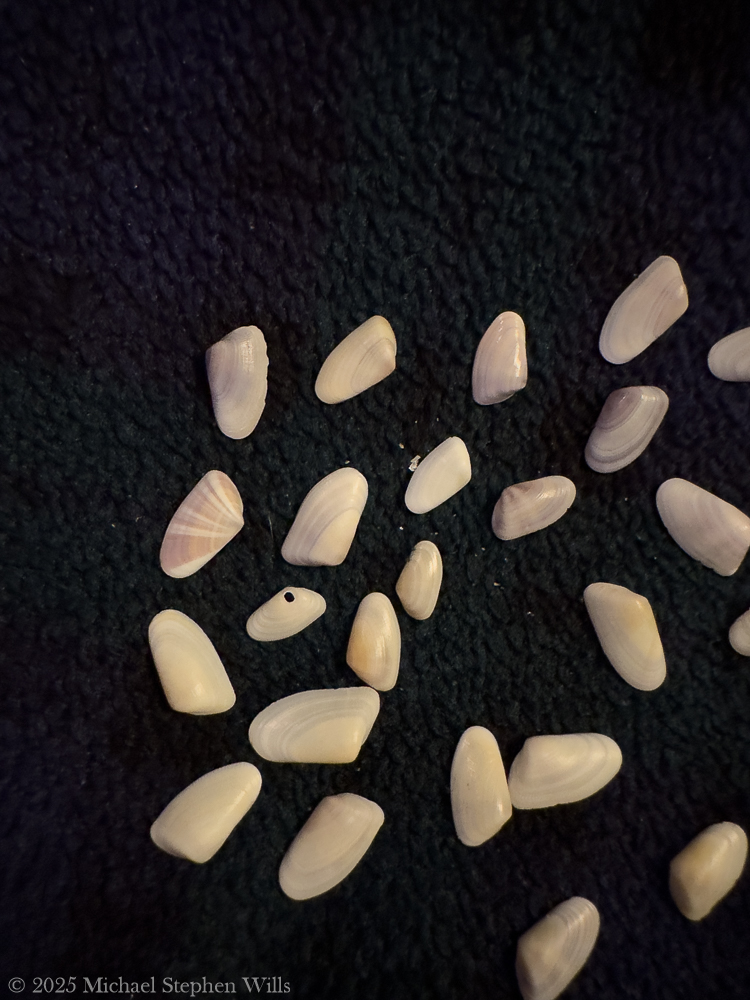
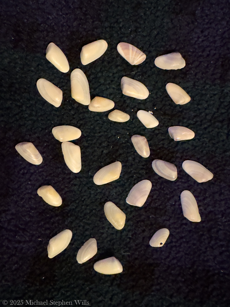
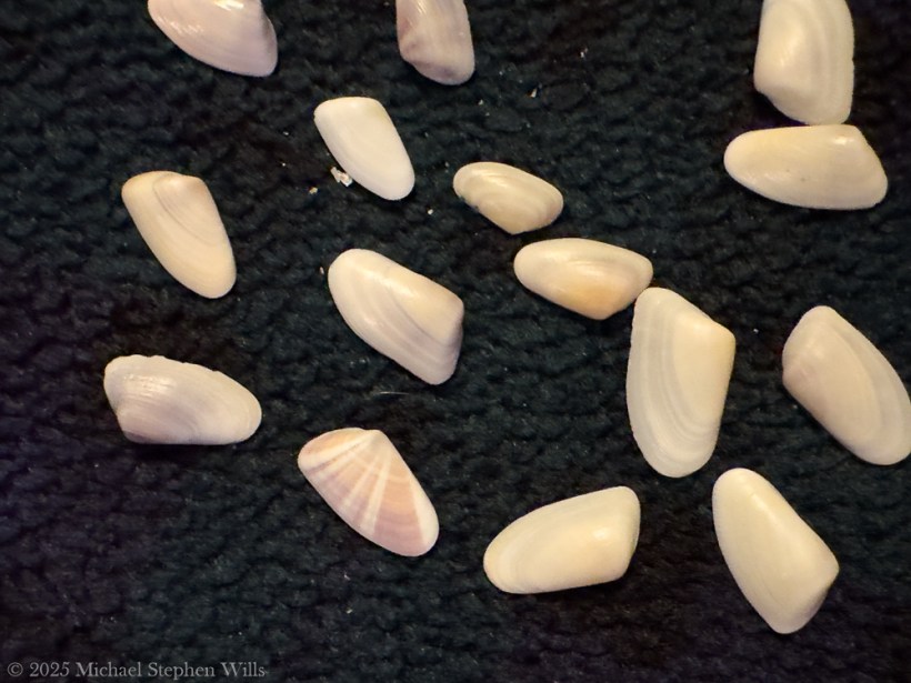
After 25 years of visiting Cocoa Beach, a discovery of coquina clams transformed my appreciation for the ecosystem, revealing its beauty, complexity, and intrinsic connections to life.
For nearly two and a half decades, I’ve strolled the sands of Cocoa Beach—since my first visit in March 2001—comforted by the rhythmic Atlantic waves and the familiar stretch of shoreline. I thought I knew this beach intimately; from the way the sunrise paints the water orange to the feel of wet sand under my feet. Yet it wasn’t until a clear morning in February 2025 that I recognized one of its tiniest treasures: the coquina clam. In the past, I might have walked past countless little shells and the tiny siphons and feet in the sand without a second glance. Now, with newfound awareness, I realize an entire world had been bustling at my toes all along.
February 2025: Discovering the Coquina Clams
Early one February morning, as the high tide receded, I noticed something magical happening at the water’s edge. Tiny coquina clams—each no larger than a fingernail—were emerging from the sand only to swiftly burrow down again between each wave.
These living coquina clams were found in the receeding high tide on a February 2025 morning on Cocoa Beach, Brevard County, Florida
Their small wedge-shaped shells, in colors of pastel pinks, purples, yellows, and whites, peeked out for a moment and then vanished, synchronized with the pulse of the ocean. It was as if the beach itself had come alive with confetti-like jewels, re-positioning themselves with every ebb and flow. I stood entranced, wondering how I’d missed this subtle dance for so many years. That morning marked the beginning of my quest to learn about these little clams that had been hiding in plain sight.
Life Beneath the Sand
Once my eyes were opened, I began observing and researching the coquina clams’ hidden world. I learned that each delicate clam is a filter feeder, siphoning in microscopic phytoplankton, algae, and organic particles from the surf. This constant filtering not only feeds the clam but also helps clean and clarify the coastal waters by removing excess nutrients. Coquinas live a fast-paced, transient life by necessity: they typically survive 1–2 years in the wild and can endure a mere few days without the ocean’s moving water.
No wonder they race to burrow when the waves recede—staying submerged is a matter of life and death, as they rely on the surf for both food and oxygen. In their brief lifespan, they continually ride the tides, migrate in swarms up and down the beach, and rebury themselves between each wave to avoid being swept away.
I found it astonishing that such small creatures possess the agility and tenacity to “surf” the waves and dig themselves back into wet sand within seconds, a graceful routine I had unknowingly witnessed that February morning.
Beyond their daily habits, coquina clams also undergo a remarkable life cycle beneath the sand. They spawn in the warmer months, releasing gametes into the water for external fertilization. The resulting larvae drift as plankton for a time before settling into the sand and metamorphosing into tiny clams. With no parental care to guide them these young coquinas must immediately fend for themselves in the surf zone. Perhaps it’s this independent, perilous beginning that drives them to cluster in large colonies—while they aren’t social in a communicative sense, hundreds of coquinas often live side by side in favorable spots, turning patches of wet sand into vibrant mosaics of color and life.
Walking the beach now, I recognize these patches: slightly raised, pebbly areas that, when a wave washes over, suddenly bristle with tiny siphons and feet as the clams feed and reposition. It’s humbling to realize that under each footstep, an entire hidden ecosystem of coquinas might be thriving.
Shells on the Shore: Beauty and Predation
With my new awareness, even the empty shells strewn along the high tide line told a story. I began to collect some of the colorful coquina shells scattered on the sand, marveling at their variety—no two looked exactly alike. Some were solid orange or yellow, others striped with purple and white, each as delicate as a butterfly wing. Many of these shells were intact, evidence of clams that had lived out their short lives or perhaps fallen prey to gentle endings. Others, however, bore mysterious perfectly round holes on their surfaces. At first glance, I thought a tiny drill had punched through them, and in a way, I was right. Those small holes are the signature of predatory snails that haunt the sands: creatures like moon snails (also known as shark’s-eye snails) and whelks that prey on coquinas by literally boring into their shells. These sand-dwelling snails wrap themselves around a clam and use a tongue-like organ called a radula—akin to a miniature saw—to drill a neat hole through the coquina’s shell, aided by acidic secretions to soften the calcium carbonate. Once the hole is complete, the snail devours the clam from within, leaving behind an empty, perforated shell as a grim calling card of the food chain in action.
Seeing those tiny “murder holes,” as beachcombers jokingly call them, on coquina shells transformed my perspective on the shell collections I had casually admired for years. Each shell in my hand represented a life that had been an integral part of the beach ecosystem. Some had been snatched by shorebirds or fish the instant they were exposed by the retreating tide, becoming breakfast for a sanderling or a pompano. Others, as the holes revealed, had been victims of an even stealthier predator under the sand. It struck me that every fragment and hollowed shell on the beach is evidence of a relationship—predator and prey, life and death intertwined on the shore. Instead of seeing a random assortment of pretty shells, I now saw a record of the beach’s vibrant food web written in calcium carbonate. The realization filled me with both wonder and respect: this sunny tourist beach holds quiet tales of survival as dramatic as any wilderness, if one knows where to look.
The Coquina’s Ecological Role
As I dug deeper (both into the sand and the literature), I discovered that coquina clams are far more than a footnote in the beach ecosystem—they are a keystone of coastal ecology. By filtering plankton and detritus from the surf, countless coquinas collectively act as tiny water purifiers, helping maintain water quality along the shore. Their presence in large numbers indicates a beach’s health; in fact, abundant coquina populations signal that the beach environment is robust and unspoiled. A stretch of sand teeming with coquina clams suggests natural, shifting sands and minimal human interference, as these clams thrive best where coastal processes remain undisturbed. In this way, coquinas are like a barometer for the shoreline: if I continue to find them at Cocoa Beach, it means the beach is still alive and supporting complex life.
Coquina clams also form a critical link in the food chain. Numerous shorebirds rely on them as a food source—those flocks of little sandpipers and plovers skittering at the water’s edge have, all along, been feasting on coquinas right under my nose. Fish that patrol the surf, like the Florida pompano and various kinds of drum (whiting), gulp them up as the waves churn the sand.
These coquina clam shells were found February 2025 on Cocoa Beach, Brevard County, Florida
Even ghost crabs and other scavengers benefit, feeding on clams that wash ashore. And of course, the predatory snails under the sand have a specialized taste for them. It’s a reminder that even a creature only an inch long can be a cornerstone of an entire food web, sustaining animals up the chain from mollusks to birds to fish. Standing on the beach now, I often pause and watch the frenetic chase of the shorebirds in the surf, aware that without the coquina clams beneath the foam, that familiar coastal ballet could cease to exist.
Humanity and the Coquina: Intertwined Histories
It’s not only animals that have interacted with coquina clams—we humans have a longstanding relationship with them as well. Historically, Floridians made use of coquinas as a food source. Local folklore and old recipes describe coquina broth and chowder, a delicate soup made by briefly boiling these tiny clams to extract their flavor.
Because each clam is so small, you’d need hundreds to make a pot of soup, so it’s not a common dish today except perhaps as a novelty. Still, the idea that the sands I walk on could literally be cooked into a chowder is a charming and earthy connection between food and place. Early indigenous peoples and European settlers alike would have recognized coquinas as an edible bounty in times when every bit of protein counted.
For best experience, click on “Watch on YouTube”
Humans have also found value in the shells of coquinas beyond admiring their beauty. Over time, vast deposits of coquina shells on ancient beaches hardened into a soft limestone rock called coquina stone (the term “coquina” itself comes from the Spanish for “shellfish” or “cockle,” reflecting its composition).
In a fascinating twist of fate, this sedimentary rock—essentially millions of fused clam shells—became a building material. Here in Florida, coquina stone was quarried and used to construct some of our oldest structures. The historic fortifications in St. Augustine, like Fort Matanzas and Castillo de San Marcos, were built from coquina stone, their walls made resilient by a matrix of coquina clam shells.
I find it poetic that the same little clams I only just learned to appreciate have literally been the building blocks of human shelters that have stood for centuries. Even today, crushed coquina shells are used in landscaping and as decorative ground cover—perhaps you’ve seen driveways or garden paths that gleam with fragments of pink and purple shells.
Our lives overlap with the coquina in subtle ways: from the architecture of coastal Florida to the aesthetics of our beach towns.
Modern conservationists note another connection: by protecting natural beach dynamics, we also protect coquina populations, which in turn supports the whole ecosystem. This means being mindful about coastal development, beach renourishment projects, and even how many shells tourists collect. I’ve become more aware that picking up a few pretty coquina shells as souvenirs is fine, but we must leave plenty behind for the beach to recycle and for other creatures to use. For example shorebirds glean minerals from them. The humble coquina clam has given me a new appreciation for how intimately tied human activity is to the smallest inhabitants of the shore.
Reflections: Wonder in the Little Things
My journeys to Cocoa Beach were enhanced: what began as a casual observation in 2025 has blossomed into a profound shift in the way I experience the beach. I feel as if I’ve been given new eyes—now I notice the glint of tiny shells in the sand and know there’s life (or a story of life) attached to each one. The joy of discovery I felt upon noticing the coquina clams has reignited a childlike curiosity in me. It’s astounding that after decades of visits, there was still a secret to uncover on those familiar shores. This realization makes me wonder: What else have I been missing? It’s a reminder that nature has layers upon layers of wonder, even in places we think we know intimately. Sometimes it just takes a shift in perspective, a bit of knowledge, or a quiet moment of attention to peel back the veil.
In reflecting on the coquina clams of Cocoa Beach, I’ve learned not only about a specific species and its role in the world, but also about myself and the value of lifelong learning. These clams, in their smallness and ubiquity, taught me to slow down and appreciate the intricate tapestry of life at my feet. Now, each time I visit the beach, I smile seeing the waves bring in that rush of foam and sand, knowing a hidden troupe of coquinas is hard at work filtering water, dodging predators, and holding up the very balance of the shore. I often kneel down now, running my fingers gently through the wet sand to feel them retreat, and I silently thank them — for cleaning the water, for feeding the birds and fish, for building historic forts (unbeknownst to themselves), and for showing me that wonder can be found in the smallest of places. Cocoa Beach, through the lens of the coquina clam, feels like a brand new world I’ve been lucky enough to discover, even after all these years
I look forward to other hidden marvels awaiting discovery on my next visit.
References
Abbott, R. T. (1974). American Seashells: The Marine Mollusca of the Atlantic and Pacific Coasts of North America. Van Nostrand Reinhold Company.
Andrews, J. (1994). Shells and Shores of Texas. University of Texas Press.
Brusca, R. C., & Brusca, G. J. (2003). Invertebrates (2nd ed.). Sinauer Associates.
Denny, M., & Gaines, S. (2000). Encyclopedia of Tidepools and Rocky Shores. University of California Press.
Futch, C. R., & Burger, J. (1976). The ecology of coquina clams (Donax variabilis) in the southeastern United States. Marine Biology Journal, 34(2), 157-168.
Leal, J. H. (2002). Seashells of Southern Florida: Living Marine Mollusks of the Florida Keys and Adjacent Regions. Smithsonian Institution Press.
Mikkelsen, P. M., & Bieler, R. (2008). Seashells of Southern Florida: Marine Bivalves, The Bivalvia. Princeton University Press.
Morton, B. (1988). Particulate Matter Processing in Bivalves: An Overview. Journal of Marine Ecology, 19(3), 103-123.
Ruppert, E. E., Fox, R. S., & Barnes, R. D. (2004). Invertebrate Zoology: A Functional Evolutionary Approach (7th ed.). Cengage Learning.
Stanley, S. M. (1970). Relation of shell form to life habits of the Bivalvia. Geological Society of America Memoir, 125, 1-296.
Voss, G. L. (1980). Seashells of the Gulf and Atlantic Coasts. Houghton Mifflin Harcourt.
Wells, H. W., & Gray, I. E. (1960). Habitat selection and the distribution of the coquina clam (Donax variabilis). Ecological Monographs, 30(1), 55-77.
Enter your email to receive notification of future postings. I will not sell or share your email address.
Copyright 2024 All Rights Reserved Michael Stephen Wills
As I stood at the edge of Punta del Este, Uruguay, I marveled at the wild beauty of the place. We were at Punta de las Salinas, the very tip of the peninsula, the edge of where the Atlantic Ocean meets the Río de la Plata. This easternmost point of Uruguay, where time feels suspended as restless waves crash against rocky shores. A sea breeze carries a distinct salty tang.
This is at Great Britain Square, Punta de las Salinas of Punta del Este. We are at the tip of the peninsula, the easternmost point of Uruguay. Punta del Este, Departamento de Maldonado, Uruguay
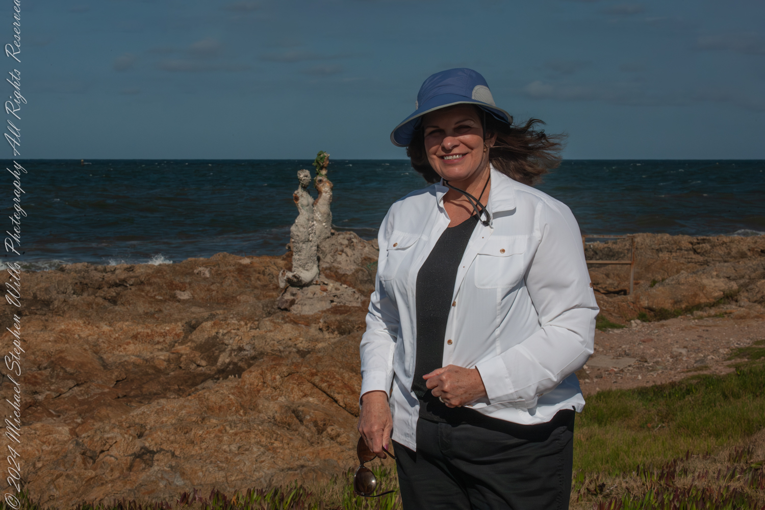
Pam, my wife, stood beside me, a bright smile on her face as the ocean wind tugged at her sunhat. Behind her, rising among the rocks, was an art installation that seemed to embody the spirit of the place “El Canto de las Sirenas” (The Song of the Mermaids). These sculptures by the artist Lily Perkins, their forms shaped and worn by the elements, appeared almost as though they were natural extensions of the rocky coastline. They gazed out to sea, their haunting beauty a poignant reminder of myth and humanity’s eternal connection with the ocean.
The sirens, crafted with an earthy texture and adorned with bits of marine debris, seemed to tell a story of resilience and adaptation. They stood stoically against the backdrop of the churning waves, their barnacle-like surfaces merging seamlessly with their rugged surroundings. I felt a strange connection to them, as if they were silent witnesses to the ever-changing dance of the sea and sky.
Pam during our 2016 South American tour. This is at Great Britain Square, Punta de las Salinas of Punta del Este. We are at the tip of the peninsula, the easternmost point of Uruguay. Over her shoulder is the art installation “El Canto de las Sirenas” (The Song of the Mermaids) (2012) by the artist Lily Perkins. Punta del Este, Departamento de Maldonado, Uruguay
The morning was perfect for photography. I adjusted my Canon camera, capturing the interplay of light and shadow across the jagged rocks, the turquoise waves, and the statues. The textures of the sirens came alive through the lens, each detail hinting at the passage of time and the endless conversations between water and stone. Pam posed in front of one of the sculptures, her presence adding a touch of humanity to the scene, as though she were part of this mythological tableau.
I took a moment to step back and absorb the scene. The coastline stretched out before me, rugged and raw, with the waves crashing in an eternal rhythm. The sirens belonged here, their forms shaped artist hands, then also by the elements. They merged into this unique place, much like the wind, the rocks, and the ocean.
As we walked along the rocky outcrop, the sound of the waves filled the air, drowning out any other noise. It was easy to lose oneself in the hypnotic patterns of the water, the spray catching the sunlight like tiny jewels. I found myself reflecting on the history of this place—Punta del Este, a meeting point of cultures and stories, a place where the natural world and human creativity converge.
Great Britain Square, where we started this journey, seemed an apt setting for such an installation. The name itself evokes a sense of exploration and connection across vast distances, much like the sirens that seem to call out across the waves. The symbolism was not lost on me as I thought about how we, too, were travelers, drawn to the edges of the earth by a desire to explore and understand.
Plaza Gran Bretana (Great Britain Square) is named for the World War II naval battle near here between the German battleship Graf Spee and the English ships Ajax, Achilles and Exeter. The plaza also has an anchor marking the boundary between Rio de la Plata and the Atlantic Ocean.
Pam and I lingered for a while longer, taking in the scenery and enjoying the peacefulness of the moment. The sculptures seemed almost alive, their forms shifting subtly as the light changed. They reminded me of the stories of sirens from ancient mythology—creatures that lured sailors to their doom with their enchanting voices. But here, they seemed more like guardians, watching over the waters and the land, their presence a testament to the enduring power of art and nature.
As the morning wore on, we made our way back, leaving the sirens behind to their eternal vigil. The experience stayed with me, though, a vivid memory of a place where myth and reality intertwine. Punta de las Salinas, with its rugged beauty and its mysterious sirens, had left an indelible mark on my heart.
Enter your email to receive notification of future postings. I will not sell or share your email address.
Copyright 2024 All Rights Reserved Michael Stephen Wills
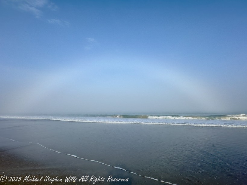
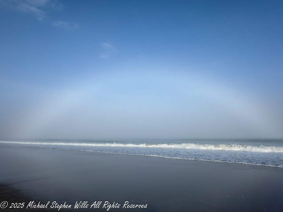
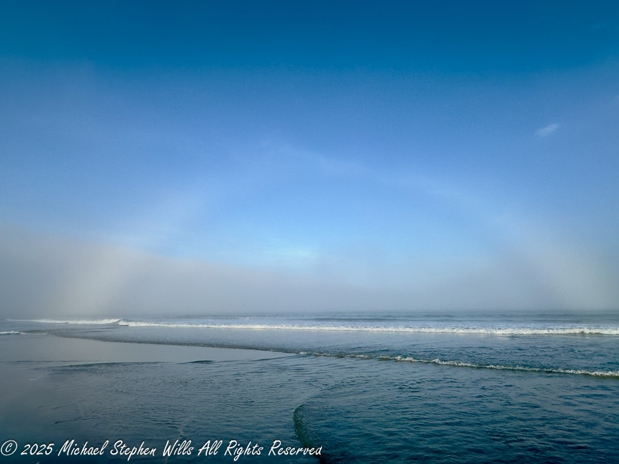
I had a haunting experience at Cocoa Beach, witnessing a rare fogbow—a ghostly arc formed by fine mist—evoking emotions and reflections on nature’s beauty.
The fog haunted Cocoa Beach for days, softening the edges of the afternoon. I had been walking along Cocoa Beach, feeling the cool ocean breeze on my face, when I noticed a change in the light. It was a little after four, the sun drifting lower in the western sky, its warmth fading into a hazy glow. The air smelled of salt and mist, and waves lapped gently at the shore, their rhythm unbroken by the deepening fog.
And then I saw it.
A pale arc stretched across the horizon, a ghost of a rainbow bending above the waves. At first, I wondered if my eyes were playing tricks on me—where were the usual bright bands of red, orange, and violet? But no, the arc was real, a fogbow, forming where sunlight met the fine sea mist. Unlike the rainbows that appear after summer storms, this one was almost entirely white, as if the ocean had conjured it from air and silence.
Sailors once whispered of such things—a white rainbow at sea, a sign of hidden land or wandering souls. Some believed it to be a bridge between realms, a fleeting passage where the living and the lost might momentarily brush against one another. Others saw it as an omen, a spectral warning of treacherous fog ahead. I wondered what the mariners of old might have thought, standing at the bow of a ship, watching a pale arc rise from the mist, its edges dissolving like breath against glass.
I stood still, watching, as the science of the moment unfolded before me. Unlike traditional rainbows, which form when light bends through large raindrops, fogbows are born from infinitesimally smaller droplets, often less than 0.1 millimeters in diameter. Their size diffuses the light, scattering it so finely that the colors blend together into a spectral whisper rather than a vibrant shout. The physics of it fascinated me—this was diffraction in action, nature bending light in a way that rendered it nearly colorless.
The effect was surreal. The fogbow arched over the breaking waves like something out of a dream, a halo of sea and sky, momentary yet timeless. It seemed to pulse in the shifting mist, visible one moment, fading the next, as if deciding whether to reveal itself fully or slip back into the fog’s embrace.
For several minutes, I just stood there, taking it in. The world felt different inside that mist, quieter, more reflective. The fog dampened the usual sounds of the beach—the calls of shorebirds, the laughter of distant walkers—leaving only the hush of the waves and the distant hum of the ocean’s breath.
I knew that fogbows were rare, requiring just the right balance of thin fog, moisture, and a low-angled sun. I was lucky to be in the right place at the right time, a witness to something subtle yet profound.
And just as silently as it had appeared, the fogbow began to dissolve. The mist thickened, swallowing its arc, the sky shifting back to its usual muted gray. But the memory of it lingered—a white rainbow over the sea, ephemeral and elusive, like a secret the ocean had briefly chosen to share.
Enter your email to receive notification of future postings. I will not sell or share your email address.
Copyright 2024 All Rights Reserved Michael Stephen Wills