A span of 10,000 years spreads between now and the first possibility of settlement on the island of Eire, then swept clean to bare rock by the weight of ice. Current scholarship of the Dún Aonghasa ruins, Inishmore, County Galway, the Irish Republic place a settlement within the inner of the four dry stone rings after 6,500 years (1,500 BC or 3,500 years ago). By way of scale, the first settlement took about 30 times the duration of the U.S. Constitution ratification through 2025: the last state, Rhode Island, ratified the Constitution 1789.
By 700 BC, 2,700 years ago, a series of upright, closely placed stones, were erected between the second and third rings called a cheval de fries field (“Frisian horses” in English) today, this defensive structure evokes the enormous scale of the struggles around this place of defense.
This is a portion of that field, I believe, taken as Pam and I approach the inner ring entrance, walking a wide path cleared of barriers. Click the photograph for a larger image with caption.
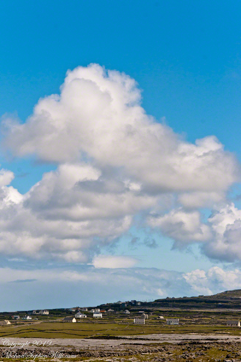
From the commanding location of Dún Aonghasa, looking northeast across Inishmore, the logic of the ancients becomes clear. No better vantage could be found—land unfurling like a hand toward Galway Bay, cottages nestled in green folds, clouds billowing above like sails caught mid-journey. A place of presence. A place of permanence.
Perched high on the cliff’s edge, the fort behind, the Atlantic at the back, the wind carried stories—unwritten, unspoken, but felt in the bones. Below, stone walls divided the island into patterns of memory. Fields outlined in rock, laid long ago by hands familiar with hardship and patience. The sea’s pulse echoed faintly in the distance, as steady and unfathomable as time itself.
No words were needed in that moment. Just the hush of sky and stone. Cottages, bleached bright by limewash—kalsomine, the old name still whispered by some—stood resilient against the elements, each one a witness to generations. Each one seemed to carry a personal reverence, a tenderness carved into the landscape.
Paths led gently inland, where wind slowed and voices from distant homes rose faintly through the open air. Along those paths, the rhythm of island life could be read in hoof prints, scattered wool, and the sharp, clean edges of hand-cut stone. There, among the hedges of limestone and wild grass, the living and the lost felt close.
The cloud cover shifted constantly. Shadows passed like thoughts across the land. Toward the shore, the sky opened wide. A silence filled the lungs, as bracing and deep as the Atlantic itself. Time seemed to slow, the mind slipping into the rhythm of the land.
Limestone pavement, rough beneath the boots, told its own tale of erosion and survival. That the earth here could sustain even the most modest farming seemed improbable. Yet here it was: a testament to stubborn hope and quiet ingenuity. In that quiet, ancient energy rose—something older than the fort, older than language. A pulse shared with the rock and wind.
The fort eventually came back into view—perched as if grown from the cliff itself, curved walls enclosing nothing but air and sky. I perceived no defensive bluster, only presence. And what a view it commanded. On days like this, the clouds formed towering cathedrals overhead, white and gold in the sun. Below, the cottages and fields seemed miniature, perfect, enduring.
The wind played echoes of prayer, lullaby, and laughter mingled with the call of seabirds. The thought came that nothing here was ever truly lost—only layered. Generation upon generation, each leaving some trace: a stone placed just so, a wall mended one final time, a cottage roof patched for another winter.
Here, even the air speaks. It moves gently but insistently, brushing the cheeks and stirring something ancient within the chest. Beneath it, the island breathes: not loudly, not urgently, but with the slow, deep rhythm of the tides.
As the sun dipped slightly westward, light changed across the fields, cottages glowing warm against darkening green. The wind softened. The clouds drifted, still massive but no longer looming. Time to return. A glance back offered one last communion with sky, stone, and silence.
Inishmore, on that day had been absorbed. Understood not with the mind, but with something quieter. Something that listens without need for words.
A roadside shrine on Cottage Road, Inishmore. The faith brought by the saints has deep roots here.
A large crucifix set with wet stone walls with cut flowers. The walls are the native limestone.
It is a spring (early June) afternoon and there are fern and wildflowers. The white flowers are Greater Burnet saxifrage (Scientific Name: Pimpinella major).
The existing dry stone wall was interrupted by the shrine. In the distance are dry stone walls around fields, a stone shed, feeding horses and the sea, being Galway Bay, storm clouds with distant rain.
Aran Islands, County Galway, Ireland.
Roadside Shrine and Island Landscape, Inishmore, Aran Islands, County Galway, Ireland
From the commanding location of Dun Aonghasa, looking northeast across Inishmore island, we can understand why the ancient builders chose this location.
We also see the transition from exposed limestone to the fields built literally from the ground up (see my post “The How of Soil”). For a closer view of island houses see my posts “Settled In” and “Cottage Road Cottage.”
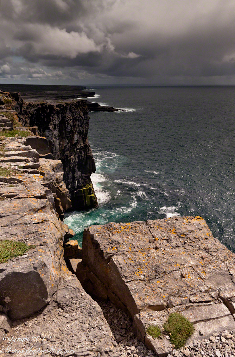
In a previous post, “Inner Ring, at last” we passed over the entrance to the inner enclosure.
A long path through fields, karst landscapes and outer walls leads to this entrance to the inner ring of Dun Aonghasa (Dun Aengus) of Inishmore, Aran Islands, County Galway, Ireland. The image composition is as a dramatic landscape with the surrounding walls and the cloudscape of an approaching storm.
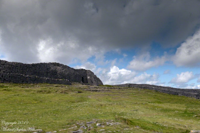
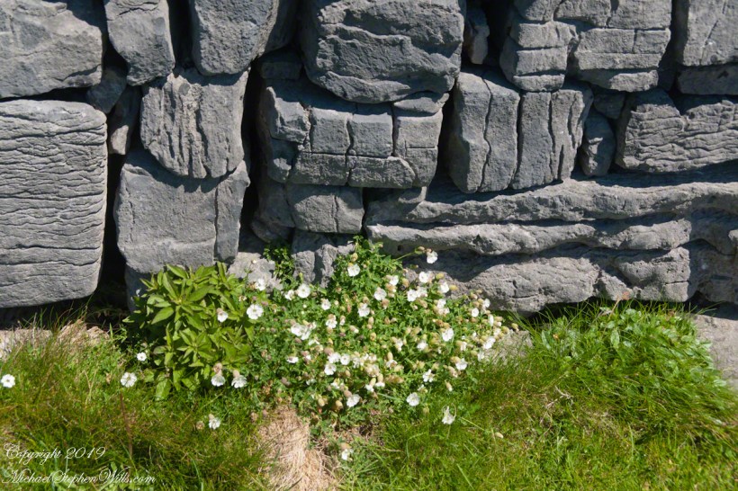
My previous post, “Inner Ring, at last”, lowered the horizon. Here, we study the base of the inner wall.
A detail of the interior wall of Dun Aonghasa (Dun Aengus) in springtime. White flowers of Sea Campion (Scientific Name: Silene uniflora) (Irish Name: Coireán mara) set against the ancient dry stone wall. Inishmore, Aran Islands, County Galway, Ireland.
We found Sea Campion throughout the west Ireland coast.
Detail of Dun Aonghasa Dry Stone Wall with White Flowers of Sea
Wishing a blessed All Saints Day (November 1st) for all my readers.
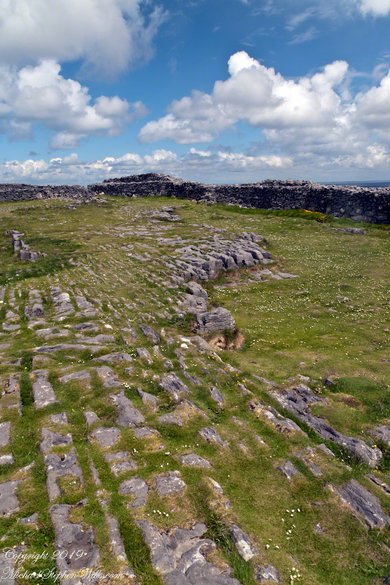
A view to the northwest from within Dun Aonghasa in springtime. The interior a karst formation (see my post, ” Galway Bay View from Dún Aonghasa”), the grikes filled with grass and a sprinkling of white and yellow flowers, a cloudscape rising over the walls. Inishmore, Aran Islands, County Galway, Ireland.
Karst Landscape with Interior Walls of Dun Aonghasa
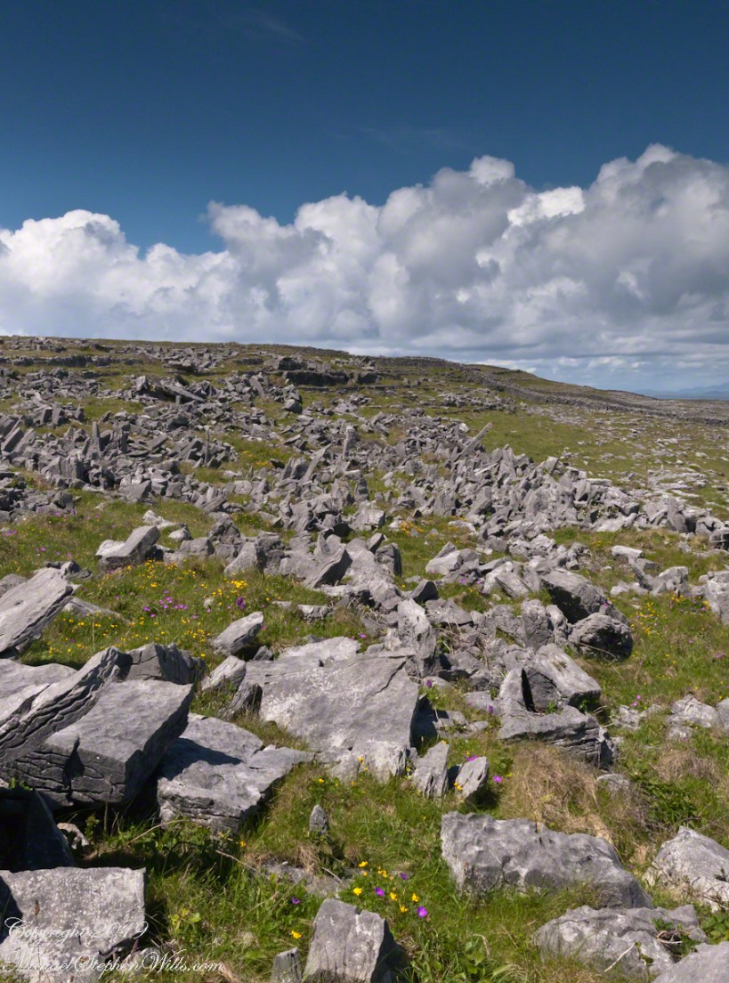
The exposed limestone of the Aran Islands here transitions to a fertile field of grass, husbanded by generations of islanders. Photograph was taken from the path on Inishmore leading up to Dun Aonghasa.
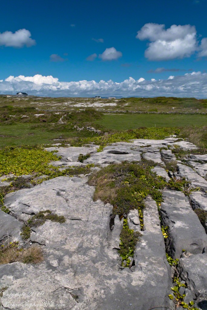
The Aran Islands are an extension of The Burren of Ireland’s Counties Claire and Galway. The word burren is from the Irish Boireann, meaning “great rock.” The glaciers that covered Ireland, retreating about 10,000 years ago, scraped down to the bedrock, exposing wide areas of limestone and dropping, here and there, large rocks. When people came along the foreign nature of the large rocks was recognized, all the more obvious for lying on the horizontally bedded, exposed limestone. We call the foreign rocks erratics. The underlying scoured rock is a pavement for a resemblance to a cobbled roadway.
The incised line, filled with grass and wildflowers, in the following photograph is called a gryke. The body of stone between the grykes are clints. Sometimes, the grykes are cross hatched and the clints resemble cobblestones or flat paving stones.
The view is northeast toward the 12 Bens of Connemara. Inishmore, Aran Islands, County Galway, Ireland
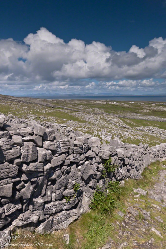
Modern stonework borders the 1/2 mile path to the inner Dún Aonghasa walls, keeping tourists off delicate plants, maintaining the integrity of this ancient site.
The view north, northwest over the walled path to Dun Aonghasa (Dun Aengus) looking across karst landscape, walled fields, farms, the North Atlantic Ocean, coast of Connemara and the 12 Bens (12 Pins) mountains. Aran Islands, County Galway, Ireland.