Under a blue February sky, Cayuga Lake keeps its icy grip, revealing how light, time, and physics conspire to make winter’s farewell a slow, luminous negotiation.
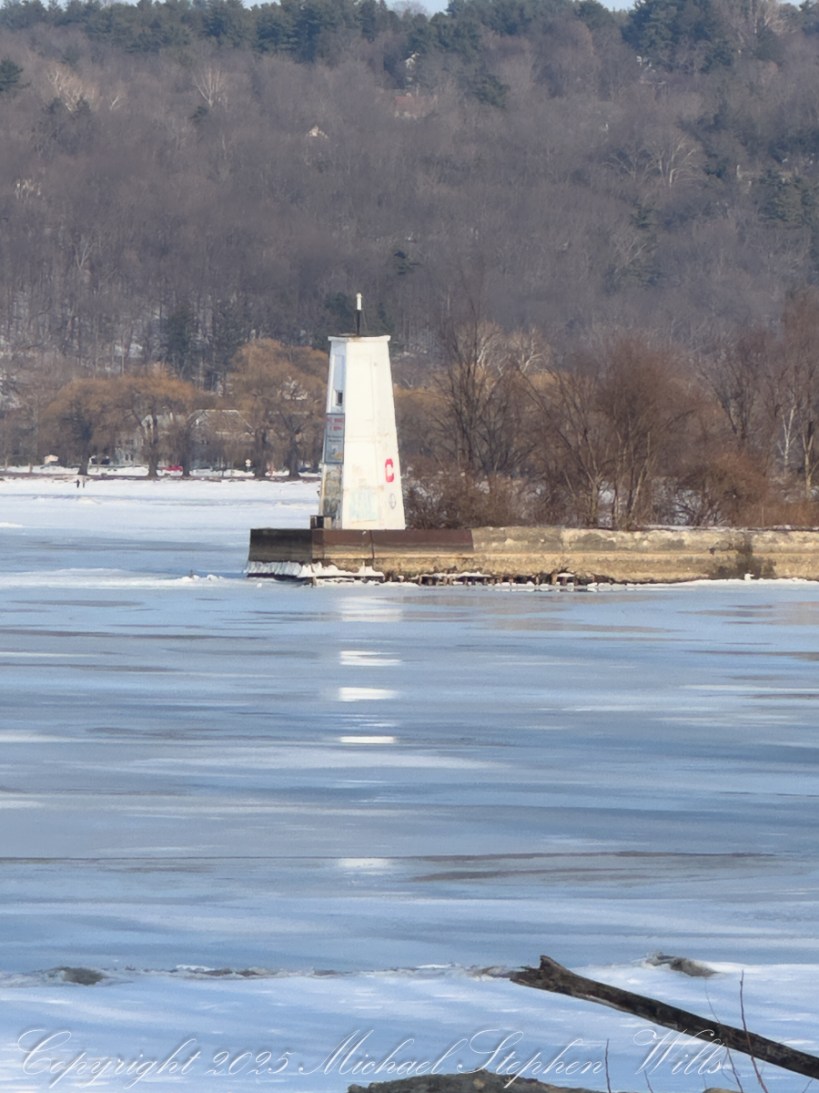
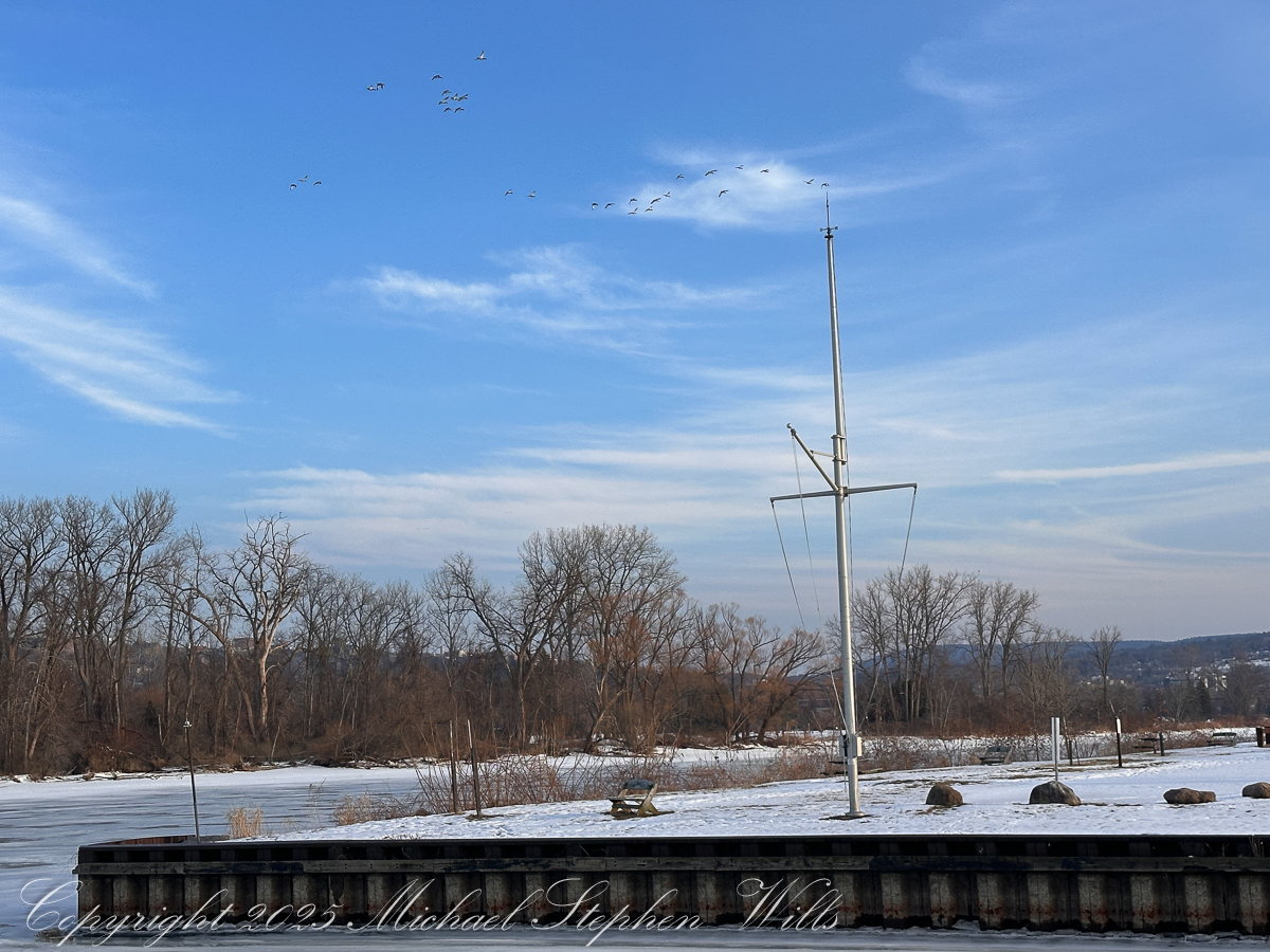
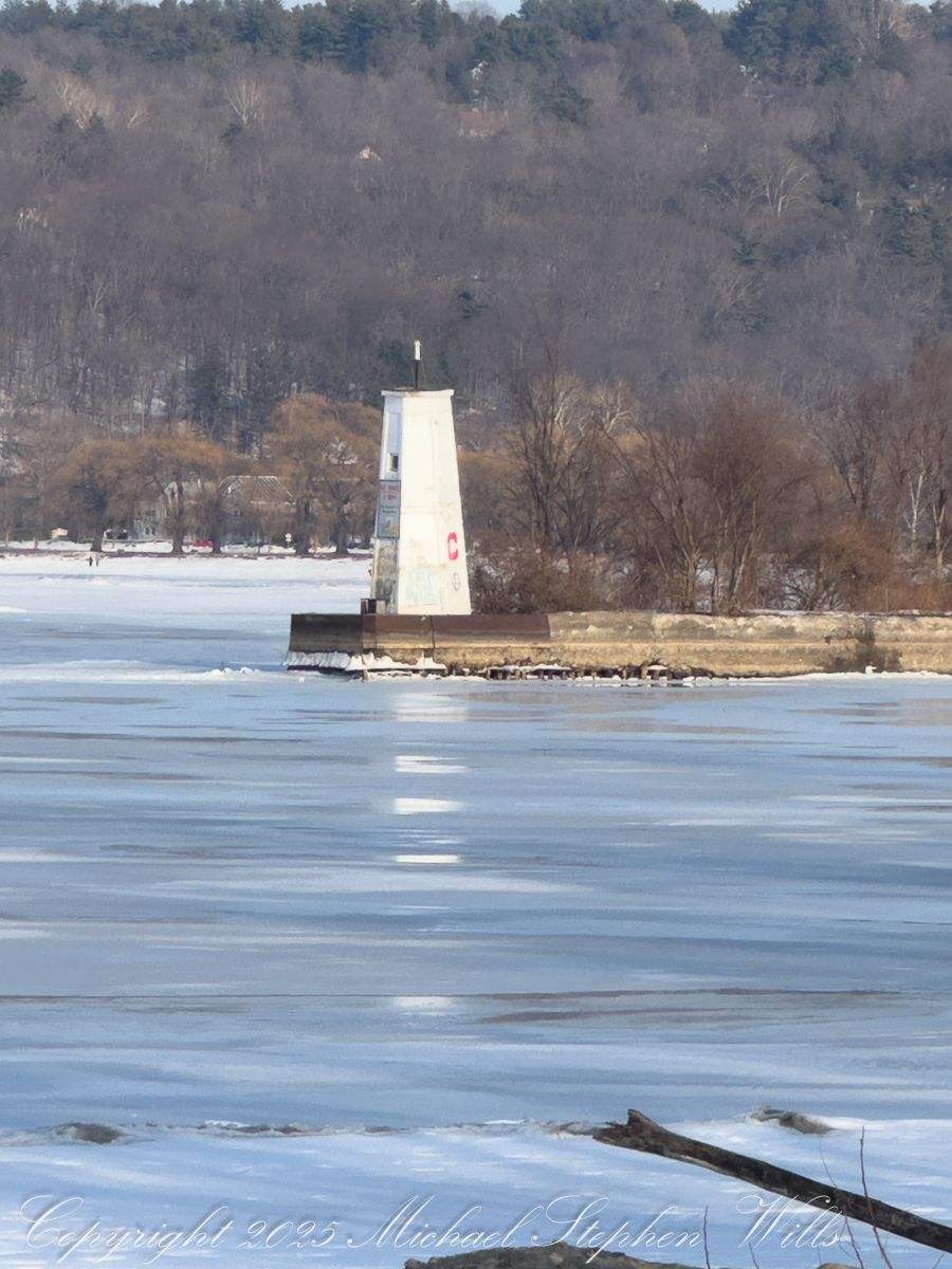
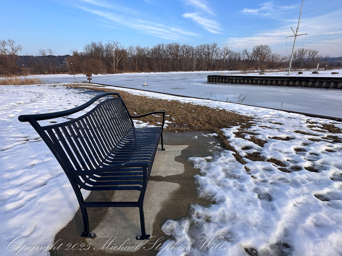
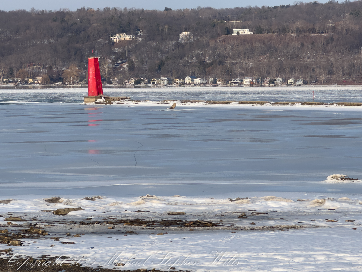
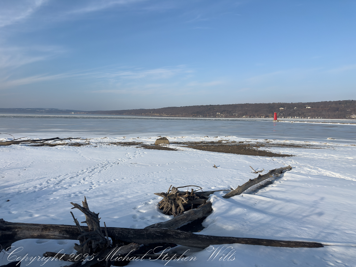
These photographs, made along the frozen margin of Cayuga Lake at Cass Park in mid-February 2026, carry a quiet paradox. The sky is a lucid blue, the light has that late-winter clarity that hints at spring, and yet the lake remains locked under a pale, glassy skin. A few geese stitch the air. A bench waits. Red and white beacons stand where water should be moving. The moment is fixed: late afternoon light in February, Finger Lakes winter—but the deeper story is written in physics, not pixels: why does lake ice linger so stubbornly during a thaw?
The short answer is that water is a hoarder of heat and ice is a keeper of promises. The long answer is the reason these scenes feel suspended between seasons.
Start with the cost of melting itself. Ice does not simply warm into water; it must first be converted, and that conversion demands a large, fixed payment of energy known as the latent heat of fusion. To melt just one kilogram of ice takes about 334,000 joules—and that energy raises the temperature not at all. It is spent entirely on changing solid to liquid.
Scale that up to a lake surface and the numbers become sobering. Even a modest sheet of ice—say ten centimeters thick—contains roughly ninety kilograms of ice per square meter. Melting that much requires on the order of thirty million joules per square meter. To put this in a human context, in 1 kcal there are 4,184 joules. Melting a square meter of ice requres 7,170 kilocalories (kcals) or 3.6 days for a person expending 2,000 kcals per day. Spread across square kilometers of lake, the energy bill climbs into the tens of terajoules. That is the hidden arithmetic behind the familiar disappointment of a February thaw: a few warm days feel dramatic to us, but to a lake they are only a small down payment.
This leads to the second, more subtle constraint: melting ice keeps itself cold. As long as ice is present, the surface of the lake is pinned near 0 °C (32 °F). Incoming heat does not make the surface warmer; it simply converts more ice into water at the same temperature. The thin layer of meltwater that forms on top is also near freezing, so the entire interface remains locked at winter’s threshold. There is no “warming momentum” here—no quick rise in temperature to accelerate the process. The system quietly consumes energy without changing its outward thermal expression.
That is why the lake in these images can look bright and almost springlike while remaining physically winterbound. Sunlight is being spent on erasure, not on warming.
A third rule of water deepens the delay. Freshwater is densest not at freezing, but at about 4 °C (39 °F). In early spring conditions, the coldest water—near 0 °C—floats. The slightly warmer, denser water below tends to stay below. This creates a stable stratification: a cold, near-freezing surface layer sitting like a lid on the lake.
The consequence is crucial. The lake cannot easily mix warmer subsurface water upward to attack the ice from below. The thaw must work mainly from the top and the edges—where sunlight, mild air, rain, and shoreline heat can do their work—rather than through a coordinated, whole-lake turnover. In practical terms, the ice is dismantled by margins and seams, not by a sudden, uniform collapse.
Add to this the reflective nature of ice and snow. The pale surface in these photographs is not merely beautiful; it is also defensive. Bright ice and snow reflect a significant fraction of incoming sunlight back into the sky. Dark, open water would absorb that energy eagerly and warm quickly. As long as the lake remains light-toned, it is actively rejecting some of the very energy that could hasten its release.
Thickness and structure matter too. Winter does not lay down a single, simple sheet. It builds layers: clear black ice, milky refrozen crusts, snow-ice composites, trapped bubbles—each a page in winter’s ledger. A brief thaw may soften the surface, open a lead near shore, or trace fine cracks across the sheet, but the bulk remains. In the closer views—the lighthouse and the red beacon standing in frozen sheen—you can see subtle tonal shifts and faint stress lines, the calligraphy of slow change. These are signs of negotiation, not surrender.
Scale, finally, is destiny. Cayuga is long and deep; it behaves more like a small inland sea than a pond. Small waters can change their minds quickly. Large waters are conservative. They remember. The heat they lost in autumn must be repaid, carefully and in full, before winter loosens its hold. This is why harbors and shallows darken first, why the margins in these scenes show hints of movement while the center keeps its pale composure.
Put together, these rules explain the peculiar patience of February ice. The thaw is not a switch but an accounting. Enormous quantities of energy must be delivered just to accomplish the phase change. While that work is underway, the surface temperature barely moves. The cold meltwater stays on top, limiting mixing. The bright surface reflects sunlight. The lake, in effect, resists haste through the ordinary, unromantic laws of physics.
There is an austere beauty in this. Ice is a temporary architecture built by the loss of heat, and its demolition requires an equally disciplined repayment. The quiet in these images is the quiet of bookkeeping—joules being transferred, layers being undone, thresholds being approached but not yet crossed. When the change finally comes, it often feels sudden: a windy day that breaks the sheet into plates, a warm rain that darkens the surface, a week when the margins retreat visibly. But that drama is only the visible last act of a long, invisible exchange.
So the lake lingers. Not out of stubbornness, but out of fidelity to the rules that govern it. Under a sky that already looks like April, Cayuga is still paying winter’s invoice. The ice remains until the account is settled—and when it finally goes, the benches will no longer face a mirror of light, but a moving field of dark water, ready once again to begin the long work of storing heat for another year.
Enter your email to receive notification of future postings. I will not sell or share your email address.
Copyright 2026 All Rights Reserved Michael Stephen Wills
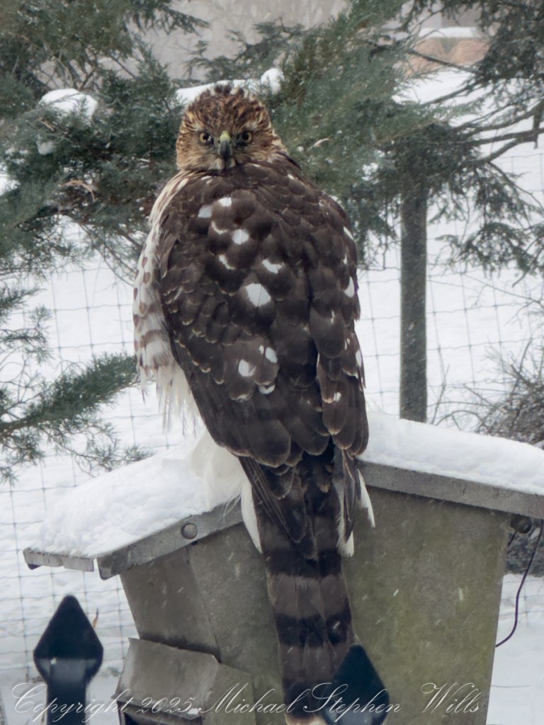
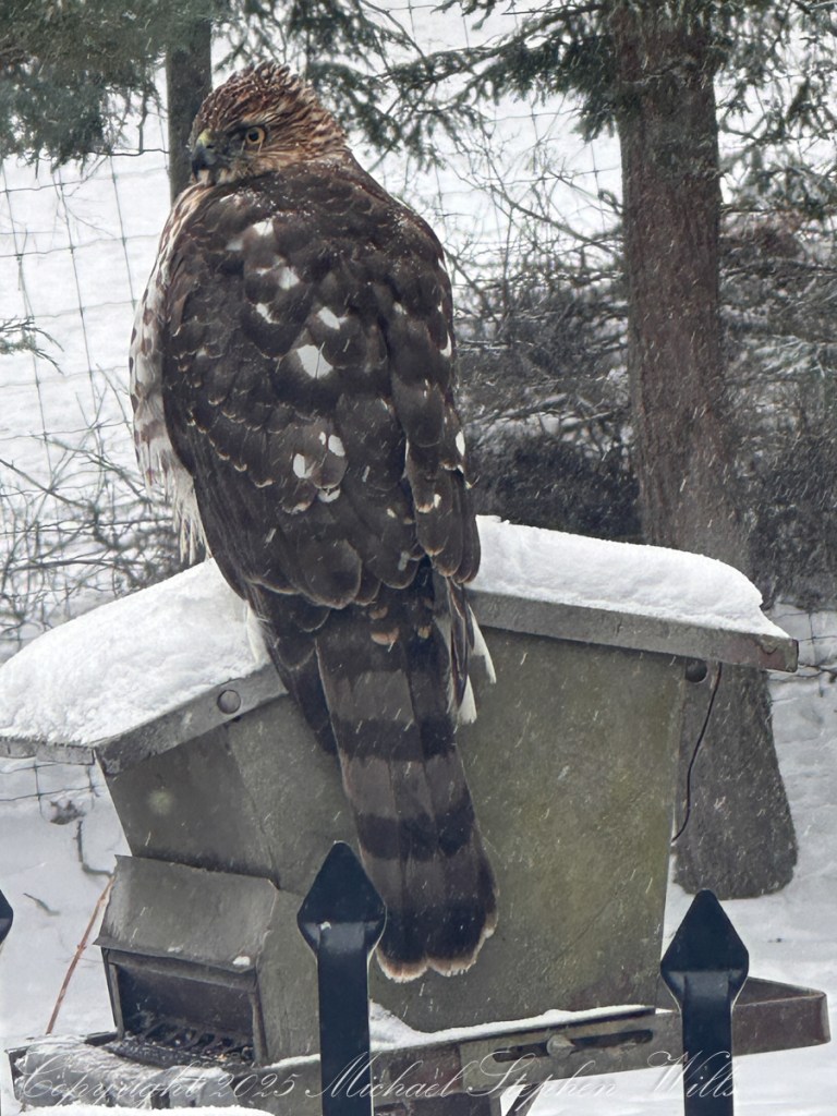
On a frigid winter morning, a young Cooper’s Hawk claimed a backyard feeder roof, revealing how predators, snow, and survival intersect in an ordinary Finger Lakes yard.
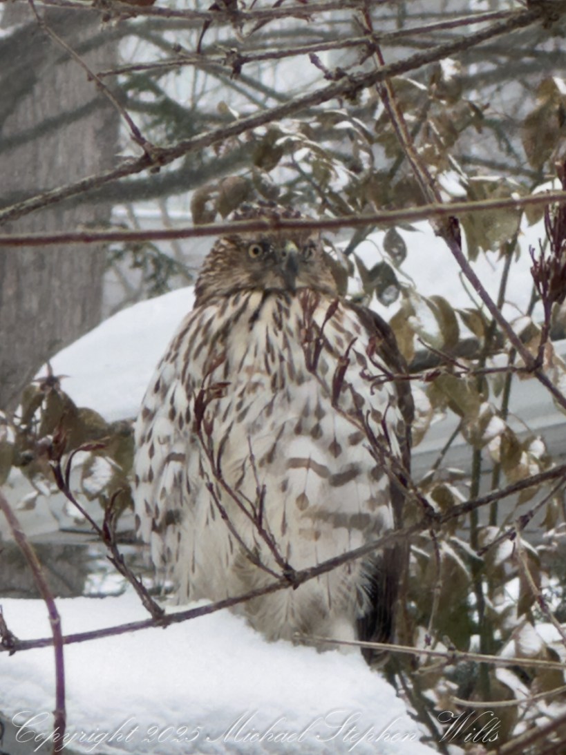
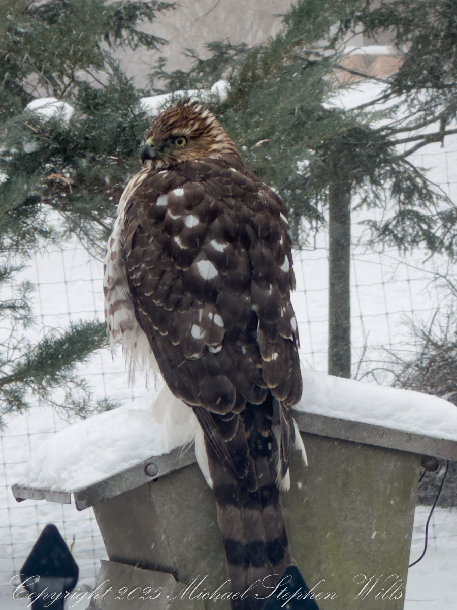
These four images and YouTube video document a winter visit by a juvenile Cooper’s Hawk (Accipiter cooperii) to our backyard feeder, captured on February 7, 2026, during a snowstorm in mid-morning light in sub-zero temperatures. The metadata places the sequence between 10:35 and 10:37 a.m., recorded on an iPhone 14 Pro Max with a 9 mm f/2.8 lens at low ISO (32) and fast shutter speeds—conditions that make sense for a bright, snowy day when reflected light is abundant and a moving subject demands short exposures. The bird itself, however, tells a longer story than the camera settings can.
Cooper’s Hawks are medium-sized accipiters, built for pursuit in cluttered spaces. Short, rounded wings and a long, banded tail allow them to thread through trees and shrubs with startling agility. In the Finger Lakes region in winter, they increasingly overlap with human habitats because bird feeders concentrate prey. The metal feeder roof in these images is mounded with snow, and the hawk has chosen it as a temporary perch—an elevated, stable platform that offers both a view of potential prey and a place to rest after a chase or to wait out a flurry of weather.
The bird’s plumage marks it as a juvenile, likely hatched the previous summer. Instead of the blue-gray back and fine rufous barring of an adult, this hawk wears brown upperparts patterned with pale, teardrop-shaped spots and a buffy, vertically streaked breast. In the first image, where the bird faces forward through a lattice of branches, those bold brown streaks on a whitish background are especially clear. The eye is yellow rather than the deep red of a mature adult—another reliable sign of youth. Over the next year or two, those eyes will darken and the plumage will transition to the cleaner, more uniform adult pattern.
In this first image, the hawk faces forward, squarely watching the yard.
The long tail, visible in the rear views, shows broad, dark bands and a pale tip. That tail is not just decorative; it is the rudder that lets the hawk brake, pivot, and surge forward in tight quarters. The posture here—upright, alert, feathers slightly fluffed against the cold—suggests a bird conserving heat while remaining ready to launch. In winter, energy balance is critical. Each failed chase costs calories, and each successful one must pay back the effort many times over.
In this second image, the hawk looks over its shoulder, scanning.
Cooper’s Hawks specialize in birds roughly the size of starlings, doves, and jays, though they will also take small mammals. Feeders unintentionally simplify the hunt by bringing many potential targets to a predictable spot. The hawk’s presence does not mean the feeder is “bad” for the ecosystem; rather, it shows the food web functioning in real time. Predators follow prey, and prey follow resources. In snowy conditions, when natural seed and cover are harder to find, that concentration effect is even stronger.
The sequence of images reads like a brief behavioral study. In the first, it faces forward, squarely watching the yard. In the second and fourth, the hawk looks over its shoulder, scanning. In the third, it turns again, keeping its head in near-constant motion—classic raptor vigilance. Accipiters often hunt by surprise, bursting from cover rather than soaring and stooping like falcons or buteos.
In this third image the hawk turns, keeping its head in near-constant motion—classic raptor vigilance.
Winter also shapes the hawk’s relationship with humans. Juveniles, in particular, are more willing to explore unfamiliar structures and take calculated risks. A feeder roof is not a natural perch, but it offers height, stability, and a clear line of sight. Over time, many individuals learn the rhythms of a yard—when sparrows or doves are most active, where cover is thickest, where escape routes lie. Some succeed and stay; others move on.
In this fourth image, the hawk looks over its shoulder, scanning.
From a broader natural history perspective, this bird represents a conservation success story. Cooper’s Hawks suffered declines in the mid-20th century due to pesticide use, but populations rebounded after bans on DDT and related chemicals. Today they are again common across much of North America, including upstate New York, occupying forests, edges, and increasingly suburban landscapes.
Watch Cooper’s Hawk behaviors in this video.
The file metadata anchors this encounter in a precise moment—February light, a cold morning, a quiet pause between hunts. The images, however, capture something timeless: a young predator learning its craft, reading the winter landscape, and testing the boundaries between wild and human-made spaces. For the backyard observer, it is a reminder that even in the most familiar settings, the ancient choreography of predator and prey continues, written in feathers, snow, and a long, banded tail poised for flight.
Enter your email to receive notification of future postings. I will not sell or share your email address.
Copyright 2026 All Rights Reserved Michael Stephen Wills
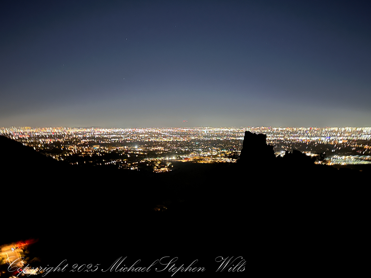
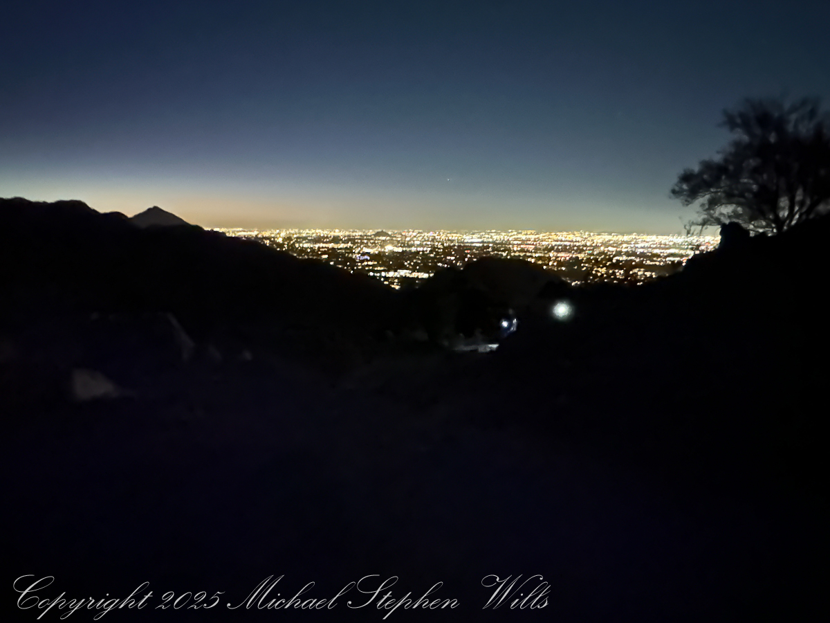
In the cool predawn, strangers from every background climb a stone stairway above Phoenix, trading city lights for desert silence as sunrise spills gold across Piestewa Peak.
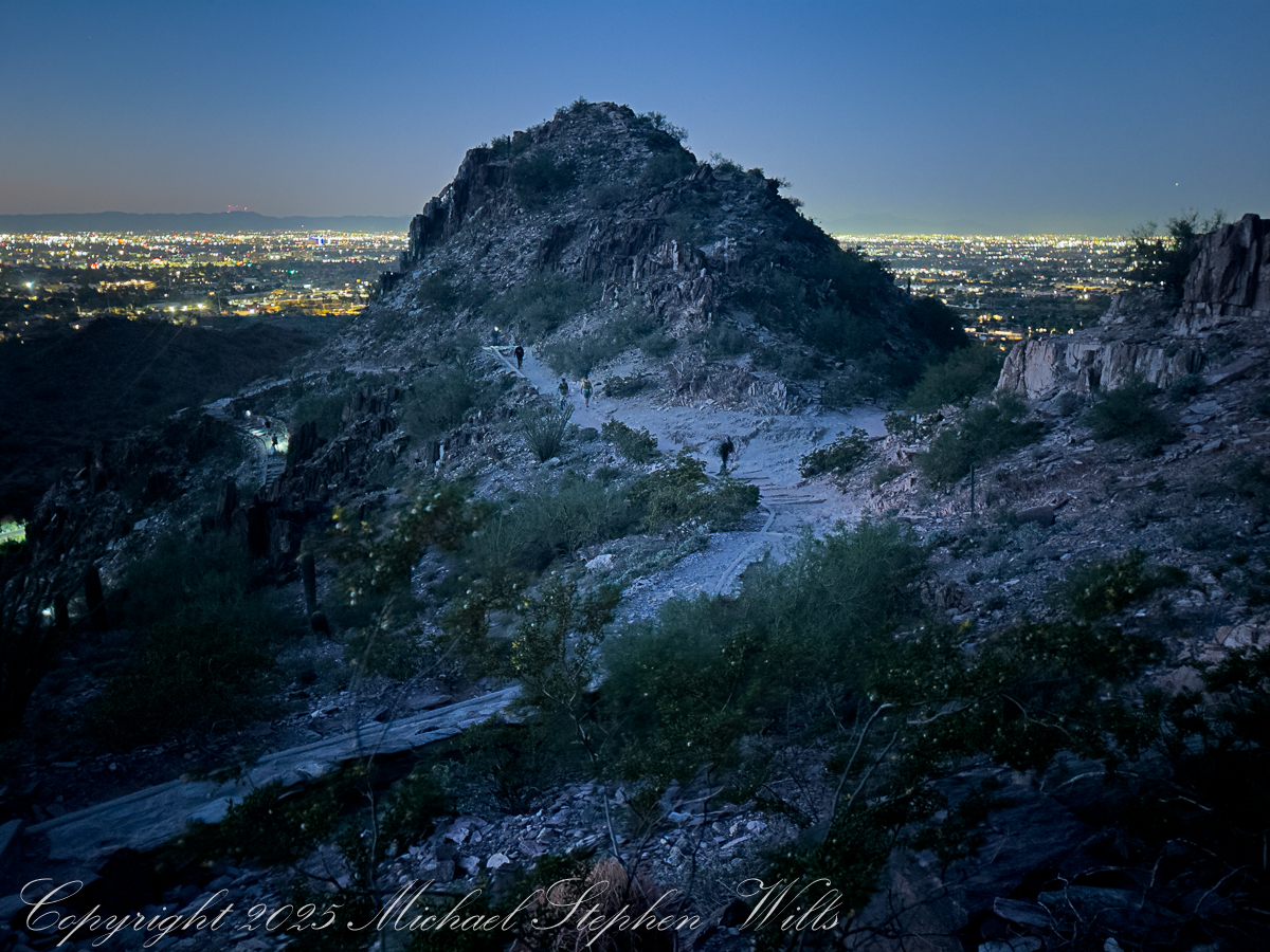
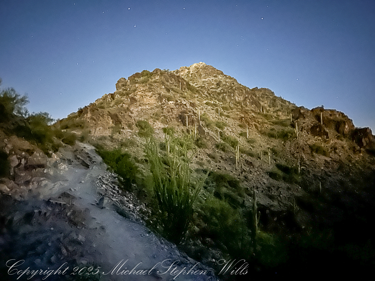
Arriving at 5 am there is a line of trucks and cars and Piestewa Peak parking almost full when I grab a spot in the predawn darkness. The desert air has that deep, merciful coolness it offers before sunrise, edged with the long-remembered scent of creosote. Car doors close with soft thuds, headlamps blink on, and a loose procession of strangers begins to funnel toward the trailhead like pilgrims, even now white and red headlamps sprinkle the upper slopes.
At first the climb exists only in a narrow cone of light, my lamp illuminates the scant gravel, uneven steps, and each scuff of boot or shoe sounds loud in the hush. Somewhere below, the city hums, but here the conversation is mostly breath and the occasional murmur of greeting as we fall into the rhythm of the climb.
My beam catches a young couple just ahead, their hands knotted together. They speak Spanish, laughing quietly as they miss a step and bump shoulders. Behind me an older man in a Veterans cap leans heavily on trekking poles, his companion—maybe daughter, maybe friend—matching her shorter stride to his with patient care. A group of women in bright leggings and braided hair moves past us in a burst of energy, their languages overlapping—English, maybe Vietnamese, something I cannot place—like the weaving of a rug. A man passes me, a drum on his back. Piestewa draws them all, before dawn, to this rib of stone in the center of the Phoenix basin.
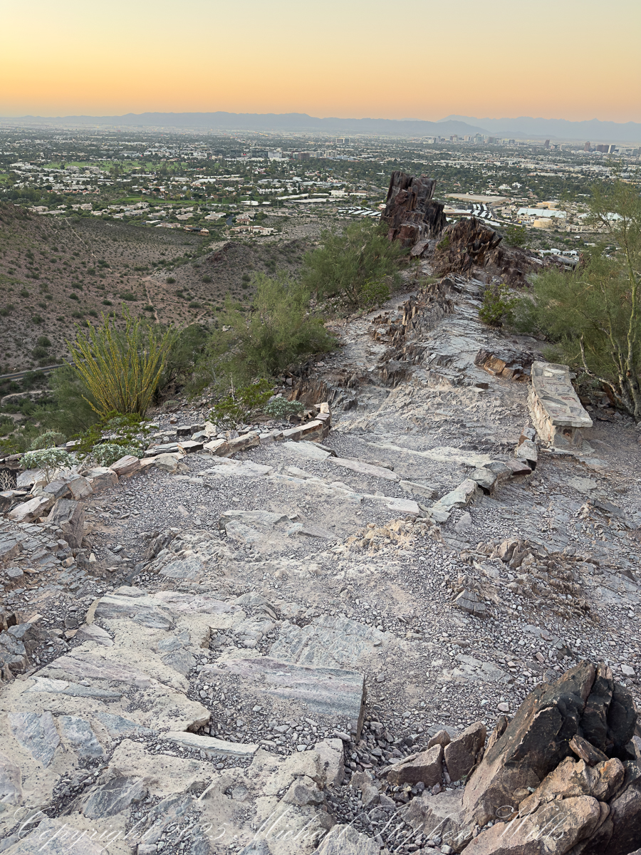
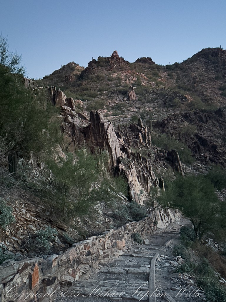
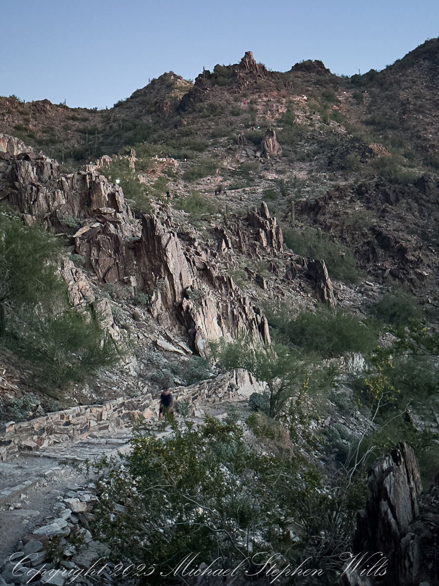
As I stop to rest myself and turn off my headlamp, ahead the trail tilts steeper the steps fade to rock, irregular and unforgiving: a stairway carved from ancient volcanic bones. With my dark adaptation, surfaces reflect star and city light, leading the eye down the ridge toward the dark quilt of neighborhoods below. Later, captured in the photograph, those steps will twist away like a stone dragon’s spine, the city waking beyond in soft pastels. Now they are simply work for legs and lungs.
The desert plants materialize around us as shapes before they acquire color. Saguaros stand like sentinels along the slopes; their arms lifted in silhouette. Ocotillo rise as witchy bundles of sticks, each spine leafed out from October rains the leaves catching a little light. On a small plateau a family has paused; the father adjusts a tiny headlamp on his son, no more than six, who is insisting, with fierce determination, that he can carry his own water. “Almost there, campeón,” his father says, and the child straightens like a soldier.
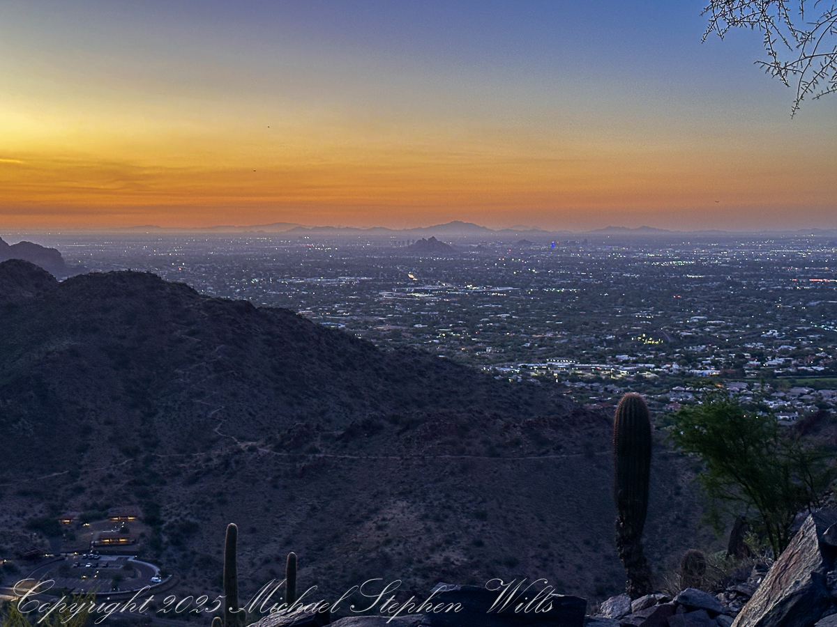
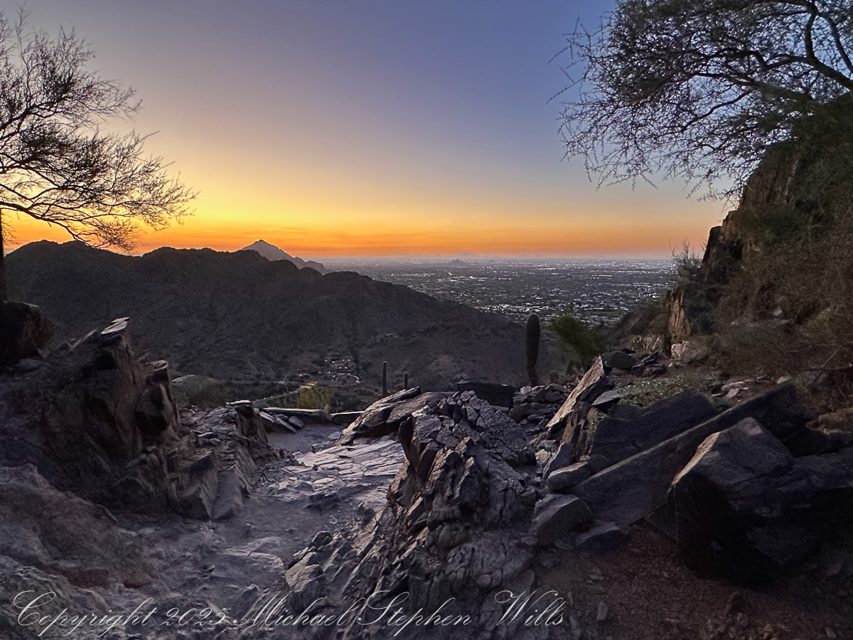
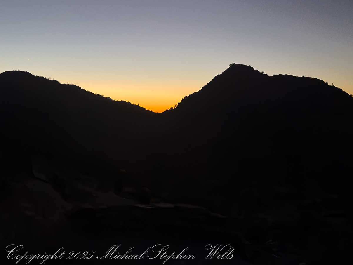
The dark begins to soften at the edges. Over the eastern horizon a thin band of orange appears, a delicate seam between night and day. In one direction, the city stretches out in a glittering net of streetlights, the squares of parking lots and subdivisions catching the last of the darkness. In the other, the mountains are still black cutouts, their profiles sharp as paper against a gradually brightening sky. One of my images will hold that moment: the jagged ridge of Piestewa in shadow, the valley below already spangled with light, a single towering saguaro rooted at the cliff’s edge like a punctuation mark.
November 2025 while visiting Pam’s family in Phoenix
Higher up, the trail narrows and the rock turns rougher. We fall into single file, strangers linked by a line of effort. A runner comes flying down, feet barely touching stone, breath steady and controlled. “On your left,” he calls, and we part for him like water. A woman with a hijab tucked neatly under her ball cap leans against the retaining wall, stretching a calf muscle, her friend counting in accented English: “Ten more seconds, you can do it.” Near one bend a hiker pauses to press a hand against the rock face, whispering a quiet prayer in a language I do not recognize. It is a small, intimate moment, gone almost before I register it.
The last push to the saddle is steep, the steps uneven, the sky now a cascade of colors—copper, rose, faint lavender melting into a high dome of blue. The silhouettes of distant ranges sharpen: the Estrellas?, the Superstitions?, low ridges whose names I do not know. On the horizon, the first thin line of sun breaks free, setting fire to the edges of clouds. In another photograph, framed by dark rock and desert trees, that sunrise becomes a golden portal at the end of a shadowed corridor of stone.
We reach a broad ledge just shy of the summit as the light finally spills over us. People are already gathered there: a trio of college students taking selfies, a pair of retirees sharing thermos coffee, a solitary man sitting cross-legged with eyes closed, face open to the warmth. The city below is suddenly transformed. The carpet of lights dims, replaced by the clear geometry of streets and rooftops, golf courses and parking lots, all laid out like a model at our feet. The mountains that hem the basin—once anonymous shapes—now reveal their ridges and ravines in sharp relief.
For a few minutes conversation dies away. Everyone seems to feel the same thing: that fragile instant when the sun clears the horizon and the desert shifts from silver-blue to gold. The rocks around us, sharp and broken in the photographs, glow honey-colored. Saguaros catch light on their spines, each thorn a tiny ember. Even the dusty air seems to shimmer.
Down below, a new wave of hikers starts up the trail, latecomers walking into full daylight. We, the predawn climbers, share a small, quiet complicity. We have seen the city from the backside of night, watched the day arrive from a perch of jagged stone. Piestewa Peak has turned us, for an hour or two, into a single, breathing organism: many hearts, one climb, all of us stitched together by the steep path and the slow unveiling of the sun.
Enter your email to receive notification of future postings. I will not sell or share your email address.
Copyright 2025 All Rights Reserved Michael Stephen Wills
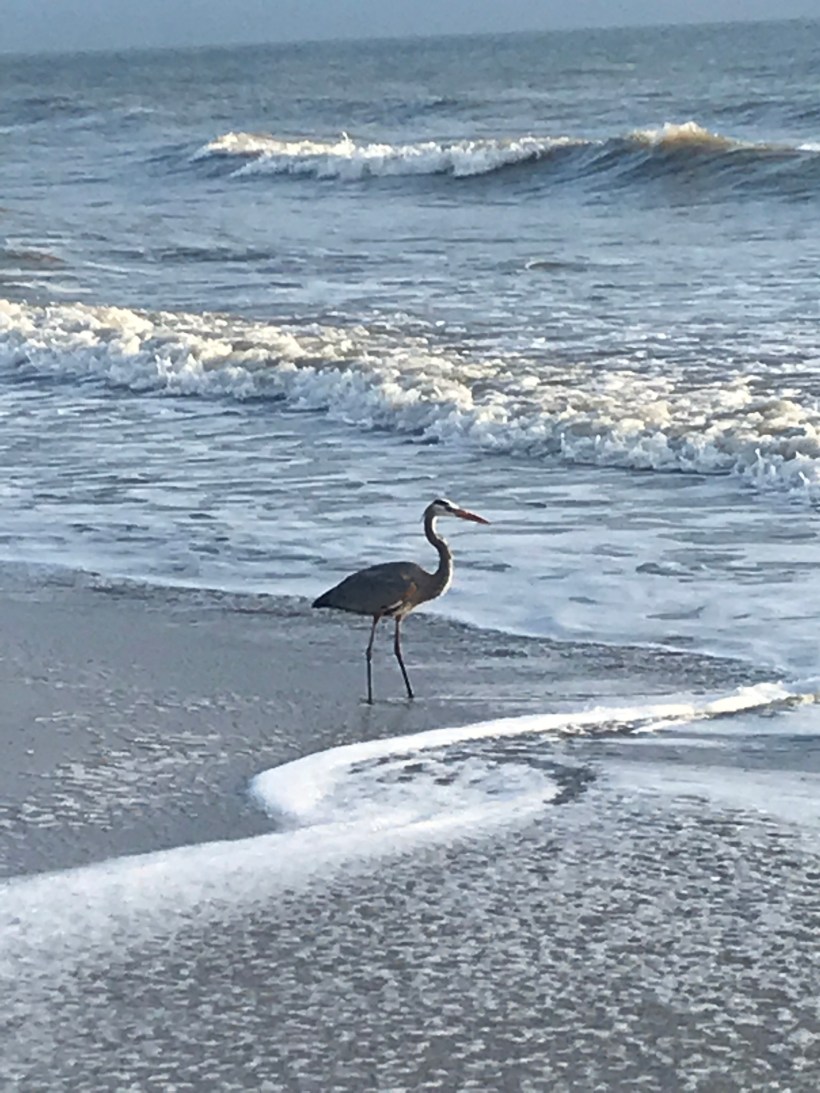
Along the luminous seam of surf and sand, a heron reads the tide’s slow grammar, patience embodied, until water yields a silver secret and morning becomes ceremony.
We walk the long seam where the Atlantic writes its restless script, and our beachcombing becomes a study in attention. The shore’s edge—where foam loosens shells from sand and the wind arranges salt on the tongue—draws other walkers too: grey herons, patient and arrow-straight, patrolling the surf line as if reading a language older than tides. They halt us without trying. We stand, quieted, while they work the boundary between water and land, between hunger and satisfaction.
I pack an iPhone sometimes for beachcombing as a lightweight alternative to SLRs. This post features iPhone photographs.
Along this narrow world of sand and surf, herons keep two distinct manners. Some linger near anglers, learning the thrift of handouts and the craft of appearing inevitable. Others refuse that bargain and hunt on their own, staking the wash with a slowness that is not delay but method. These independent operators move along the ocean’s margin: high enough to let the breakers fold ahead of them, low enough that their long legs stir the small lives hidden in the cross-hatching currents. To follow one with the eye is to adopt a different clock. Sandpipers skitter and dash; the heron lengthens time.
A perfect place to stalk the surf
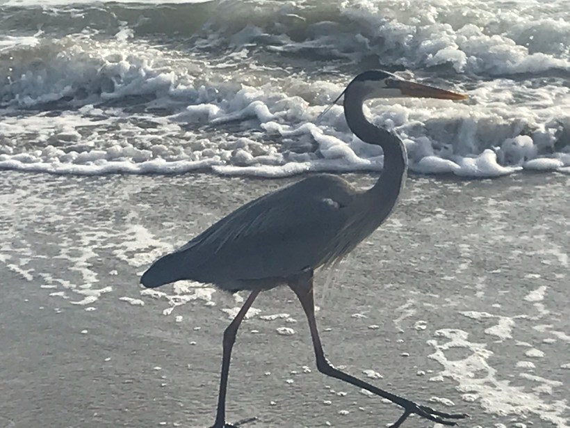
At first the bird seems merely spellbound by light on water. Then a shift: a narrow cant of the head, the smallest realignment of the eye to the glare. The neck—serpentine and stored with intention—uncoils quick as a strike, and the bill cleaves the surface. The world either yields or it doesn’t. Often it doesn’t. When it does, the beak lifts an impossibly large, glinting fish, as if the ocean had lent out a secret.
Success!!
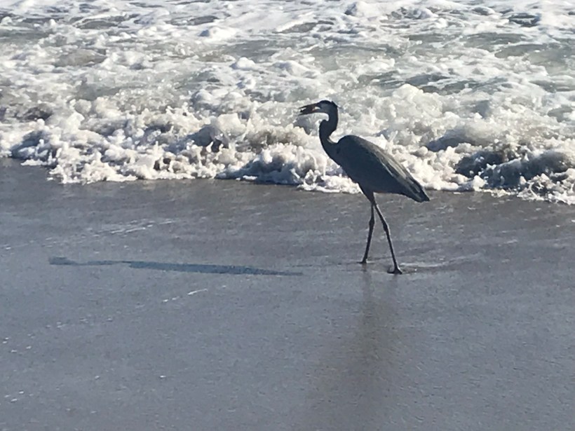
What follows is ceremony. The heron stands and calibrates, turning the silver length with almost invisible nods until head and prize agree. A sharp jerk aligns the fish with beak and gullet; the upper throat swells, accepting the whole, unchewed. Two more pulses and the catch is a memory traveling inward. It is an astonishment every time, not because we do not understand what is happening but because we do, and still it exceeds us.
We carry a smart phone on these morning circuits, a slim stand-in for heavier glass, enough to witness without intruding. Backlit by the early sun, the herons are cut from bronze and shadow, working the luminous edge while the day composes itself behind them. In the afternoons we meet fewer of the solitary hunters when the strand belongs more to the opportunists near the thinning knots of anglers. Why the shift, we cannot say. The ocean has its schedule; so, it seems, do its readers.
If we keep our distance, we are permitted to watch. Cross a line we don’t perceive and the bird will rise all at once, the long body unfolding, the voice a rasping scold torn from the throat of reed beds and marsh dawns; but, grant it enough space, and the heron returns us to the lesson it keeps teaching: that patience is a kind of movement; that the boundary of things is where change is clearest; that the most astonishing acts require the courage to do very little, very well, for a long time.
We come to linger where the waves erase our tracks, apprenticed to that slow grammar, trying to learn the tide’s careful verbs before the light turns and the day becomes something else—a different text, the same shore, the heron already a thin signature against the horizon.
Enter your email to receive notification of future postings. I will not sell or share your email address.
Copyright 2025 All Rights Reserved Michael Stephen Wills
Discover the Buttonbush (Cephalanthus occidentalis), a wetland shrub of spherical blooms, sustaining pollinators, birds, and waterfowl while reminding us of life’s enduring cycles
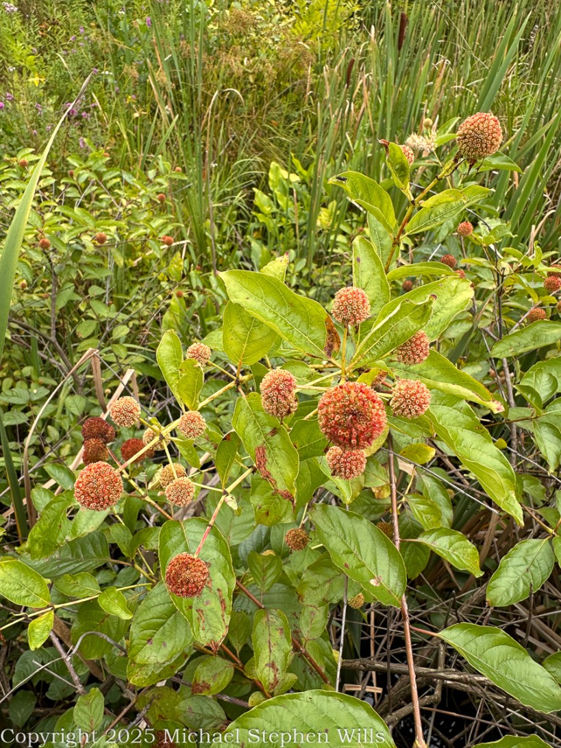
In the quiet wetlands of late summer, when cattails lift their brown torches above the reeds and dragonflies skim the still water, there is a shrub that speaks in spheres. Its language is not the pointed spear of grass or the broad fan of lily pads, but the perfect symmetry of globes—round, intricate, and startling in their precision. This is the Buttonbush, Cephalanthus occidentalis, a native of swamps, pond margins, and the soft, yielding soils where water shapes the land.
At first glance, its clusters might be mistaken for something fashioned by human hands: spiky balls arrayed along slender stems, each one a small planet bristling with tiny cells. Only in memory can we recall their summer incarnation, when each ball was a constellation of snowy blossoms, white tubular flowers extending like delicate pins from a spherical center. Bees and butterflies crowded them then, drunk on nectar, wings glinting in the sun. Hummingbirds darted in as though drawn by an unseen magnet, their beaks fitting perfectly into the narrow blossoms, a partnership written long ago in the shared script of evolution.
Buttonbush (Cephalanthus occidentalis) at Sapsucker Woods, Cornell Lab of Ornithology
Now, in August’s waning light, those blossoms have folded back into seed, transforming into the russet orbs captured in the photograph. What was once nectar is now promise—food for ducks, shorebirds, and the small lives that depend on wetlands for sustenance. In the hands of buttonbush, time itself is circular. Flower becomes fruit, fruit becomes seed, seed becomes shrub, and the cycle spins quietly on, just as the spheres themselves suggest: complete, unbroken, eternal.
A Wetland Companion
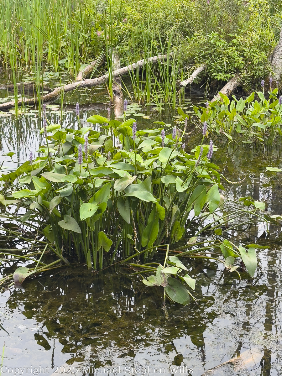
Buttonbush is rarely alone. It thrives where cattails whisper, where pickerelweed thrusts up spikes of purple bloom, where the air holds the scent of waterlogged earth. Its roots grip the muck at the edges of ponds and rivers, holding soil against the restless tug of currents. In doing so, it becomes part of the unseen architecture that holds wetlands together, slowing erosion, filtering water, providing shelter for fish in the shade of its stems.
Pickerelweed (Pontederia cordata) at Sapsucker Woods, Cornell Lab of Ornithology
This shrub, unassuming in stature, is an engineer of stability. It creates thickets where red-winged blackbirds perch, where frogs crouch in shade, where turtles bask on half-submerged branches. The wetlands of North America would be poorer without its presence, for it provides not just beauty but the scaffolding upon which entire communities of life depend.
The Human Thread
To the human eye, the buttonbush’s spherical blooms are so striking that they demand metaphor. Some have called them pincushions, others tiny planets, others fireworks arrested in mid-burst. Native American peoples, however, looked beyond metaphor to medicine. The bark and roots were used in remedies for ailments ranging from headaches to fevers, though with caution, for the plant holds mild toxicity when consumed raw. It is a reminder that many gifts of the natural world are edged with danger, and that wisdom lies in balance.
Today, gardeners and conservationists plant buttonbush intentionally. It is welcomed into rain gardens, where its thirst for moisture makes it a perfect ally for absorbing stormwater. It is used in wetland restoration projects, where its deep roots anchor new life. And it is cherished by those who walk the edges of ponds and discover in its round blossoms a geometry that feels both wild and deliberate, a gift of design from the living earth.
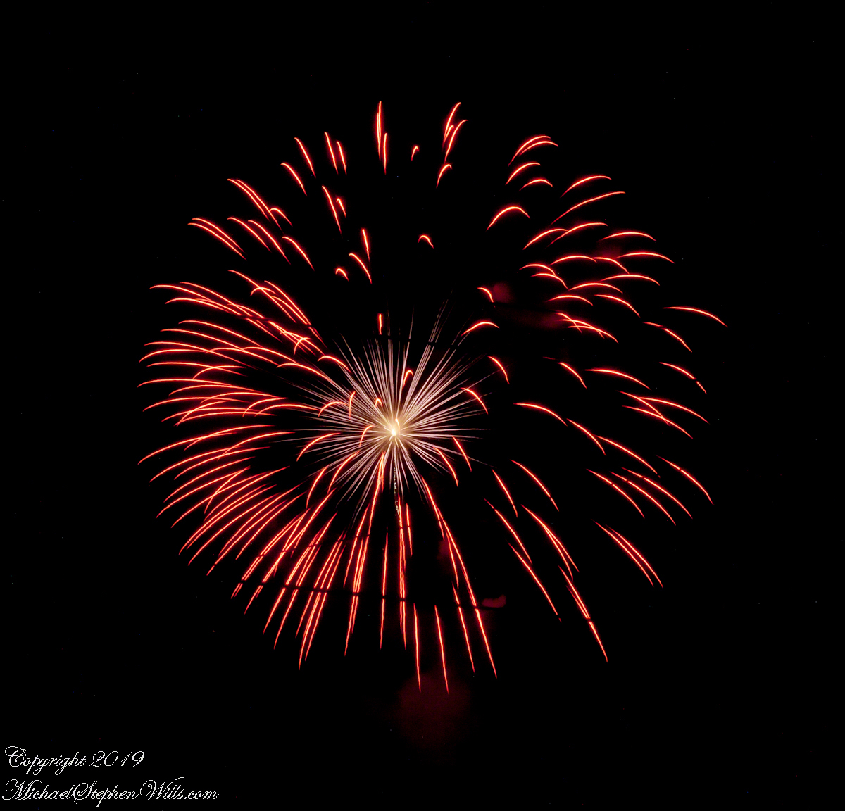
Fourth of July, 2019, Stewart Park
The Sphere as Symbol
Rachel Carson once wrote that in nature, “nothing exists alone.” The buttonbush embodies this truth with clarity. Its spheres are invitations, junctions where plant and pollinator meet, where flower and bird share a moment of mutual necessity. They are offerings to the eye as well, challenging us to see patterns where we might otherwise see only happenstance.
Standing before a buttonbush in bloom, one feels an almost childlike wonder: how could such symmetry arise unbidden from soil and sunlight? Yet this is the miracle of evolution, that order may spring from chance, that beauty may serve survival, that what pleases our senses also sustains life.
A Closing Reflection
In the wetlands, where water mirrors the sky, the buttonbush offers its own reflection of completeness. Its seed heads persist through autumn and winter, small orbs clinging even when leaves fall, reminders that the cycles of life turn steadily beneath the stillness.
To linger with buttonbush is to be reminded of nature’s quiet insistence on wholeness. It speaks in forms: round, repeating, enduring. To walk away from it is to carry a sense of connection, to know that in the pattern of its blooms we glimpse a truth both humble and profound—that life is not a line but a circle, and in every turning there is renewal.
For Further Reading
USDA NRCS. Plant Guide: Buttonbush (Cephalanthus occidentalis L.). United States Department of Agriculture, Natural Resources Conservation Service. Available online: https://plants.usda.gov – Provides detailed information on identification, habitat, and ecological role.
Lady Bird Johnson Wildflower Center. Cephalanthus occidentalis (Common Buttonbush). Native Plant Information Network. Available online: https://www.wildflower.org/plants/result.php?id_plant=ceoc2 – Covers botanical features, bloom time, wildlife value, and landscape use.
Dirr, Michael A. Manual of Woody Landscape Plants: Their Identification, Ornamental Characteristics, Culture, Propagation and Uses. 6th Edition. Stipes Publishing, 2009. – Authoritative horticultural reference on Buttonbush and other shrubs.
Peterson, Roger Tory, and Margaret McKenny. A Field Guide to Wildflowers: Northeastern and North-central North America. Houghton Mifflin, 1968. – Classic field guide covering buttonbush’s wetland habitat.
Carson, Rachel. Silent Spring. Houghton Mifflin, 1962. – Source of the quoted passage: “In nature nothing exists alone.” (Chapter 2, “The Obligation to Endure”).
Moerman, Daniel E. Native American Ethnobotany. Timber Press, 1998. – Comprehensive reference documenting traditional medicinal uses of Buttonbush among Native American peoples.
Enter your email to receive notification of future postings. I will not sell or share your email address.
Copyright 2025 All Rights Reserved Michael Stephen Wills
At Ashford Castle, swans glide on the Cong River’s glassy waters, weaving together myth, history, and cinema in a timeless reflection of Ireland’s enduring spirit.
Headed south from Cong Village, past the venerable Cong Abbey then Saint Mary’s Church of Ireland, the road bends into the Ashford Castle estate. Time seems to shift here. The stonework of the abbey lingers in memory, only to give way to manicured parkland, ancient trees, and the shimmer of water. The road itself, aptly named Ashford Castle, carries the traveler to a place where history, nature, and imagination meet.
I do not recall passing a guard box on my first visit, though one now stands firmly on the roadside, manned and proper, as though the estate were never meant to be entered without ceremony. In truth, Ashford Castle has always carried the air of a threshold—between village and wild, past and present, myth and reality.
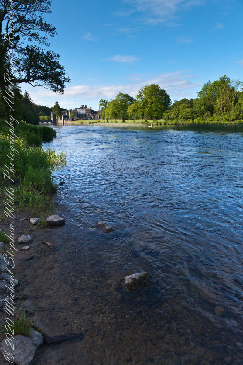
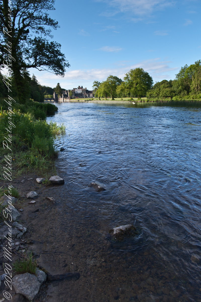
Soon the road brings one to the banks of the Cong River. Here the water widens, flowing calm and sure, and across it rises the battlemented silhouette of Ashford Castle itself. Its towers, turrets, and stony walls seem to grow from the riverbank like something inevitable, a fortress transformed into elegance. The castle’s mirrored reflection on the water doubles the grandeur, as though the real and imagined castle exist side by side.
It is no wonder filmmakers found inspiration here. Scenes from the classic 1952 film The Quiet Man—the tale of Sean Thornton, played by John Wayne, and the fiery Mary Kate Danaher, embodied by Maureen O’Hara—were shot on the far bank of this very river. To watch them walking by these waters is to see Ashford Castle woven into Hollywood’s Irish dreamscape, a backdrop both romantic and enduring.
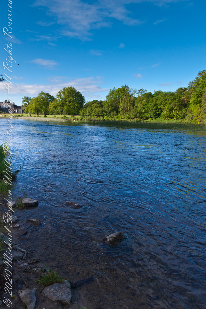
Yet long before cinema, the river was already a stage. The Cong River is a natural marvel. It emerges from the same Carboniferous limestone that shapes the Burren of County Clare—an austere landscape of limestone pavements etched with fossils and caves, where rare alpine and Mediterranean plants thrive among ancient tombs. Through fissures in this ancient bedrock, the waters of Lough Mask find their way underground before rising again at Cong. This subterranean journey, through stone filters laid down some 350 million years ago, leaves the water clarified, luminous, and cold. By the time it slides past Ashford Castle, it has the purity of glass.
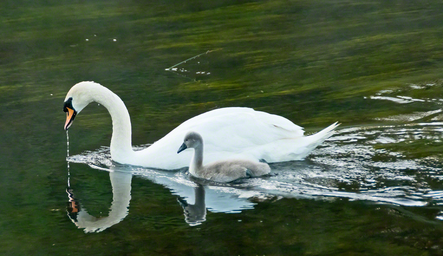
It is in this clarity while walking the opposite bank on a different morning I found a parent swan and its cygnet feeding. The adult glided, immaculate, its long neck bowed as drops of river fell from its beak. At its side, the cygnet paddled with earnest strokes, gray down still clinging, a fragile shadow of what it would one day become. Together they traced a quiet path across the water, ripples fanning behind them.
Few images so perfectly match their setting: a medieval castle, guardian of centuries, reflected in the same waters where these swans carried on their timeless rhythm of nurture and growth. It was as if the river itself composed the scene—a blending of stone, water, bird, and sky that belonged nowhere else but here.
The swan has long been a symbol in Irish lore. The Children of Lir, cursed to live as swans for nine hundred years, are among the most haunting figures of Celtic mythology. To see the white bird with its offspring before Ashford Castle was to glimpse that myth breathing still, alive on the Cong River.
Photographers know the difficulty of capturing water and stone without losing the life between them. On that morning, however, the river gave freely—its surface alternately smooth as glass and dappled with breeze. Stones at the water’s edge appeared like stepping-stones into history. Each frame revealed another face of the estate: the wide reach of the Cong, the castle framed by trees, the play of cloud shadows across the current.
The castle itself, though reshaped as a luxury retreat, still speaks of older times. Founded in the 13th century by the Anglo-Normans, Ashford passed through centuries of conquest and change before becoming, in the 19th century, a romantic Victorian pile. Today its battlements remain picturesque rather than defensive, but the sense of continuity—of lives unfolding along these banks—has not faded.
Standing there, camera in hand, I was struck by the layered meaning of this place. The Cong River flows from unseen caverns, purified by limestone older than memory. It nourishes swans, reeds, and trout alike. It reflects both a castle and a sky. Along its opposite bank, legends of cinema and Celtic lore alike find footing.
As the swan and cygnet drifted slowly downstream, I thought of them as part of the same enduring thread. Parent and child mirrored castle and village, past and future, permanence and change. The ripples they left widened until they touched both banks, an unbroken gesture across centuries.
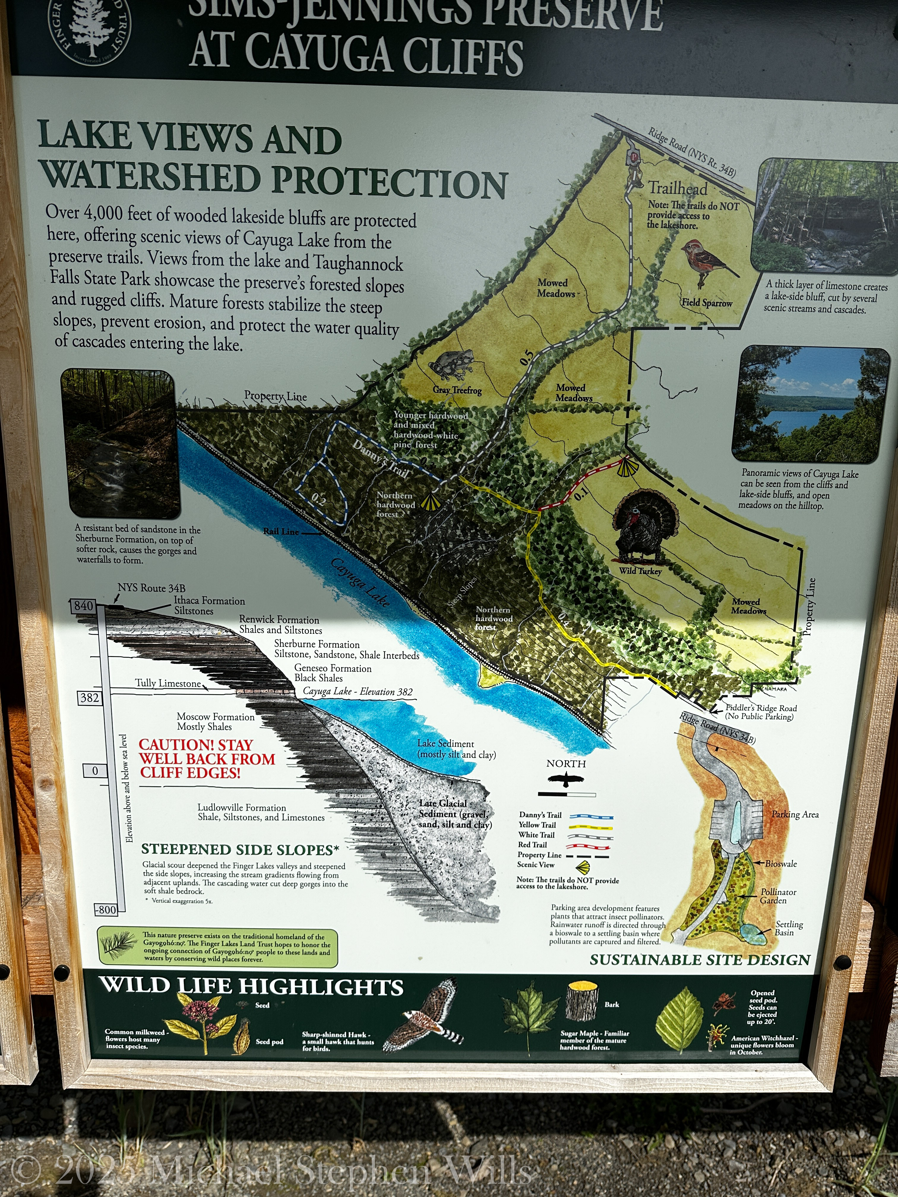
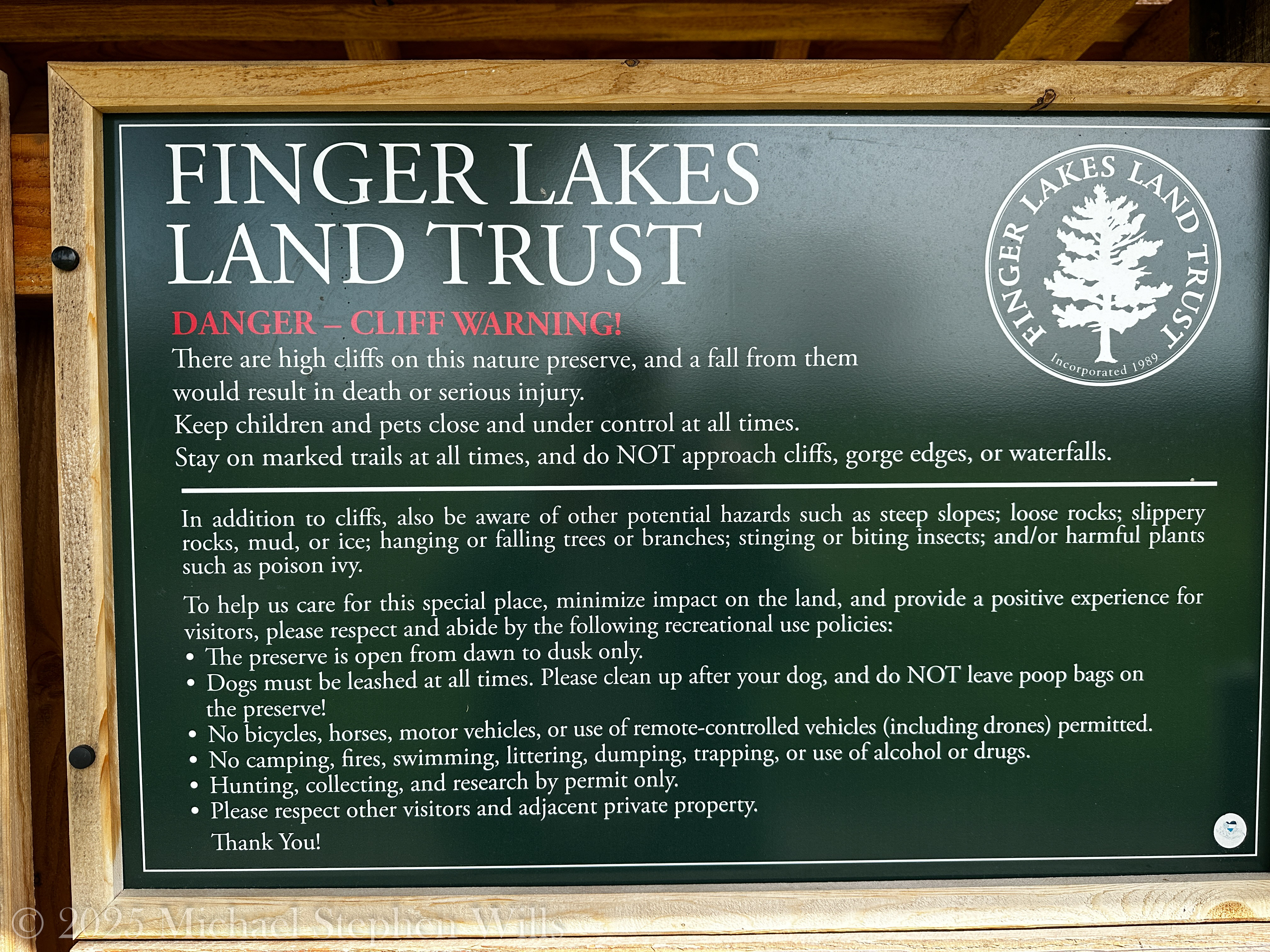
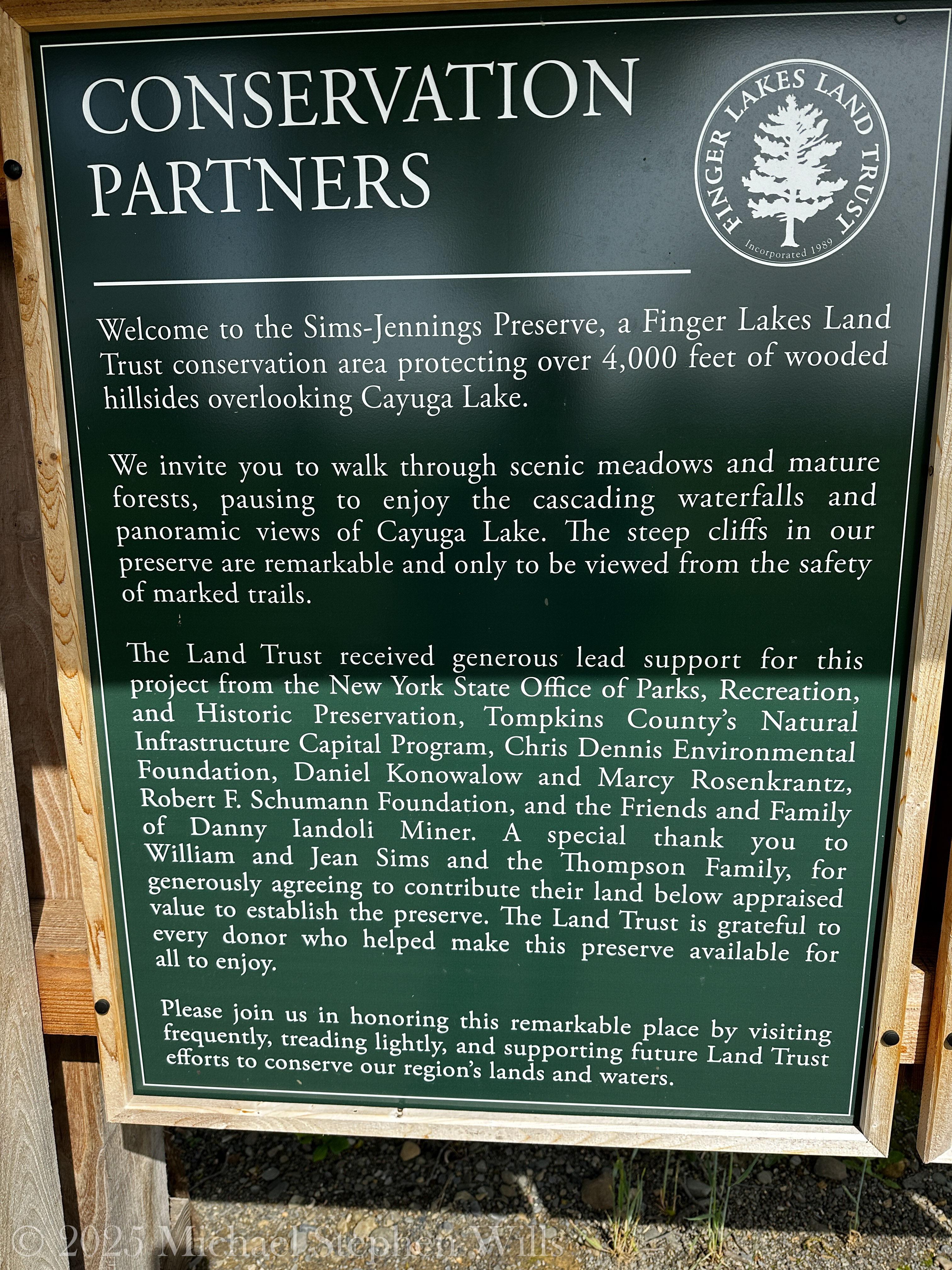
A walk through Sims-Jennings Preserve unveils ancient cliffs, vibrant bird calls, and the quiet wisdom of maples and waterfalls along Cayuga Lake’s forested edge.
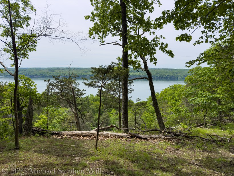
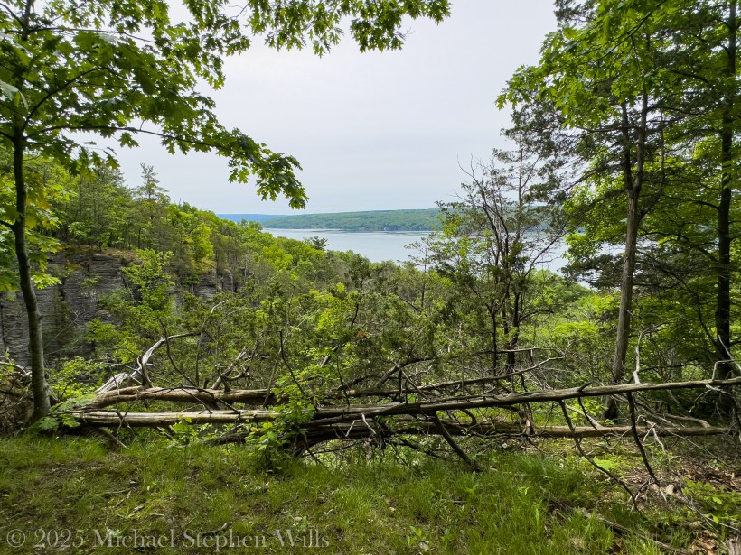
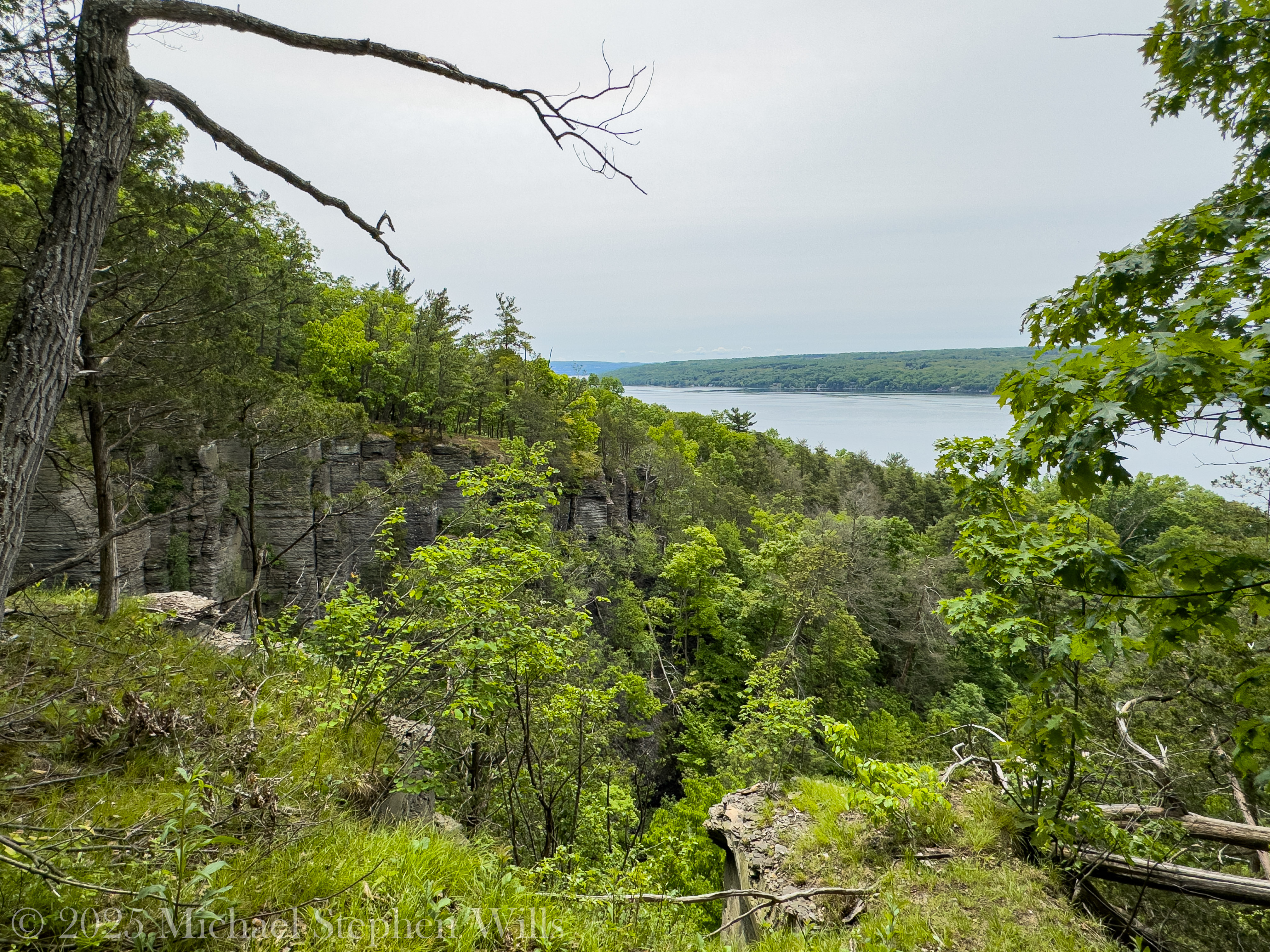
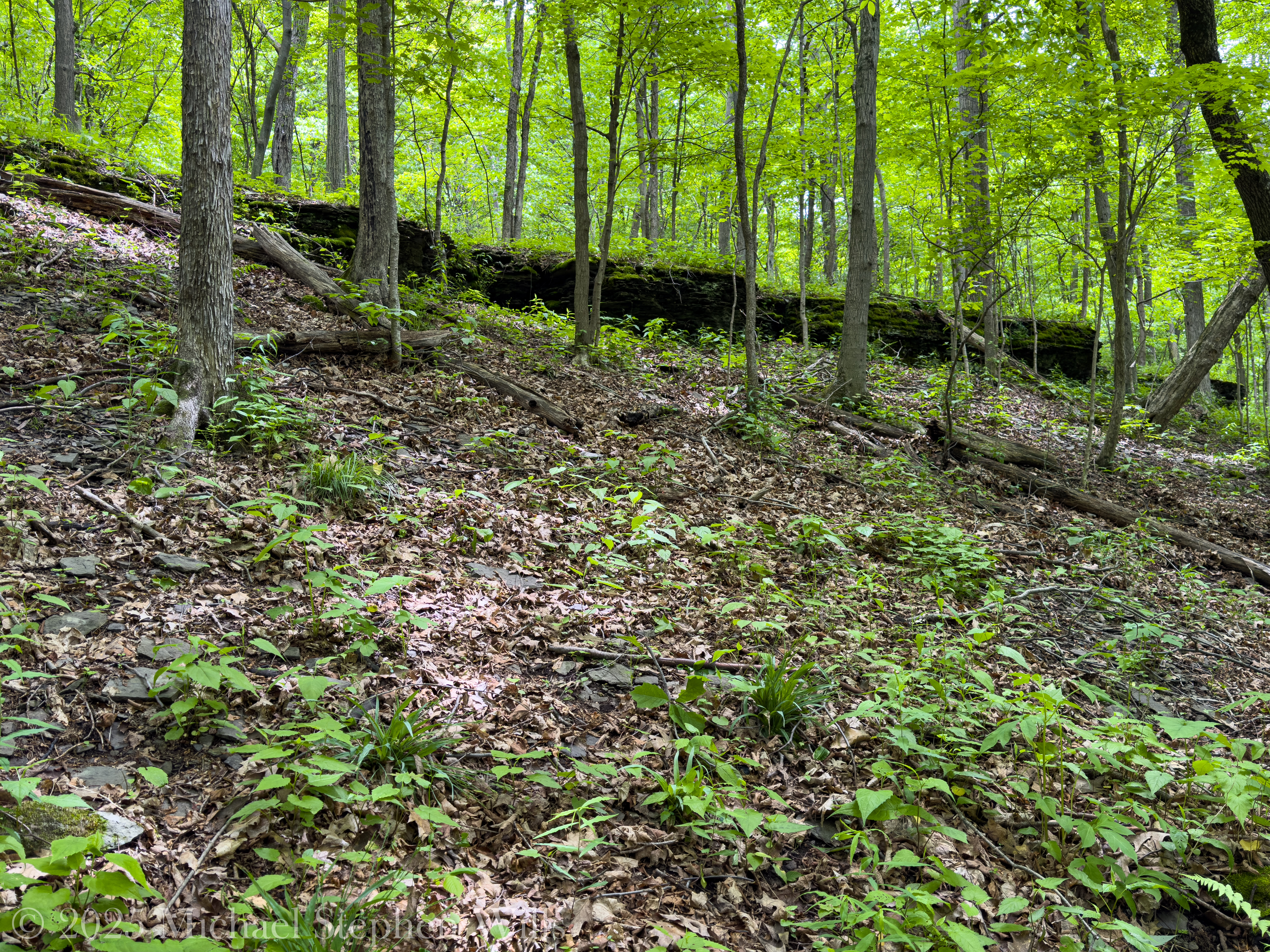
I arrive early, the sun still climbing its slow arc, brushing the eastern sky in pastels as I step into the Sims-Jennings Preserve at Cayuga Cliffs. The trailhead, tucked neatly along NYS Route 34B, is a doorway into an ancient chapter of the Finger Lakes—one rich with the scent of moss, the hush of leaf-dappled silence, and the layered echoes of stone and birdsong.
The first thing that strikes me is the expanse of mowed meadow, rimmed with goldenrod and patches of milkweed. From here, the land rolled gently westward until it ends abruptly in cliffs that plummeted toward Cayuga Lake. A map at the entrance speaks of the Sherburne and Renwick Formations, shale and siltstone laid down when the land was covered in warm Devonian seas. The cliffs themselves stand like watchmen over time, protecting 4,000 feet of lakeshore from erosion, whispering tales older than mammals.
A side trail leads to this mowed meadow and Cayuga Lake overlook
On the meadow edge is this Carya ovata, or shagbark hickory, unmistakable from its elongated leaflets and distinctive bark that peeled in long, curled strips. The leaves shimmered in the breeze, their green etched with pale speckles of recent rain, as if nature herself had hand-painted them.
Shagbark Hickory on the edge of meadow.Leaves of the Shagbark HickoryShagbark Hickory bark / trunk
I follow the yellow-blazed trail into a thicket where tall sugar maples—Acer saccharum—arched overhead. Their leaves caught the morning light, each palm-sized blade glowing like a shard of stained glass.
Throughout the preserve I find large holes like these in a pine tree snag, the work of a Pileated Woodpecker.
A sudden fluting note from the trees stops me in my tracks. “Ee-oh-lay,” the Wood Thrush sang, its call cascading through the forest like water over stone. Moments later, the rapid, accelerating trill of an Ovenbird joins in—a sound like “teacher-teacher-teacher” echoing from the understory. The forest is alive.
Watch on YouTube for the best experience.
I descend into the shade. A narrow stream runs over the flat gray ledges of the Ludlowville Formation, forming delicate waterfalls no taller than a man but intricate as lace. One fall, framed by a colonnade of black cherry and beech trees, poured over stone like a ribbon of silk. The water’s voice changed with each ledge—first a murmur, then a chuckle, then quiet confidence as it wound through the woods.
Here, a Scarlet Tanager flashes like flame through the canopy, its red feathers shocking against the sea of green. Above, the Eastern Wood-Pewee calles its own name from a high perch—“pee-a-wee”—a humble herald of summer. Lower down, a Tufted Titmouse flits from branch to branch, a gray blur with a whistle like curiosity incarnate.
Further along, a looping vine coils around a pair of trees like an ancient signature. Possibly a native bittersweet, its woody stem thick as a child’s arm. It reminds me of how all life here is entangled—flora, fauna, stone, and stream woven into one vast web.
I pause at the overlook, where the trail skirts the cliffs. From this height, the view opened to Cayuga Lake, vast and gleaming in the morning light. Across the water, the hills of the western shore softened into a watercolor horizon.
Crowbar Point on the west lake shore is visible, partially hidden by trees. Sims-Jennings Preserve at Cayuga Cliffs, Finger Lakes Land Trust on a May morning 2025, Lansing, Tompkins County, Finger Lakes Region
On the walk back, a robin sings its measured phrases from a nearby hawthorn, and I think how common birds often hold the deepest solace. The robin’s voice rises above the silence, not grand, not rare, but reassuring in its familiarity—like a good friend’s greeting.
A shale ledge, Renwick Formation (?)
I leave the preserve changed gently, like the soft indent of a footstep in moss. The Sims-Jennings Preserve at Cayuga Cliffs is a place that reminds you to listen. To the birds, to the trees, to your own breath. And in listening, you remember what it means to be wholly present in the world.
Enter your email to receive notification of future postings. I will not sell or share your email address.
Copyright 2025 All Rights Reserved Michael Stephen Wills
On a serene May morning, a small flock of Rose-breasted Grosbeaks graced the author’s yard, showcasing their vibrant plumage and bringing beauty to the tranquil scene of nature.
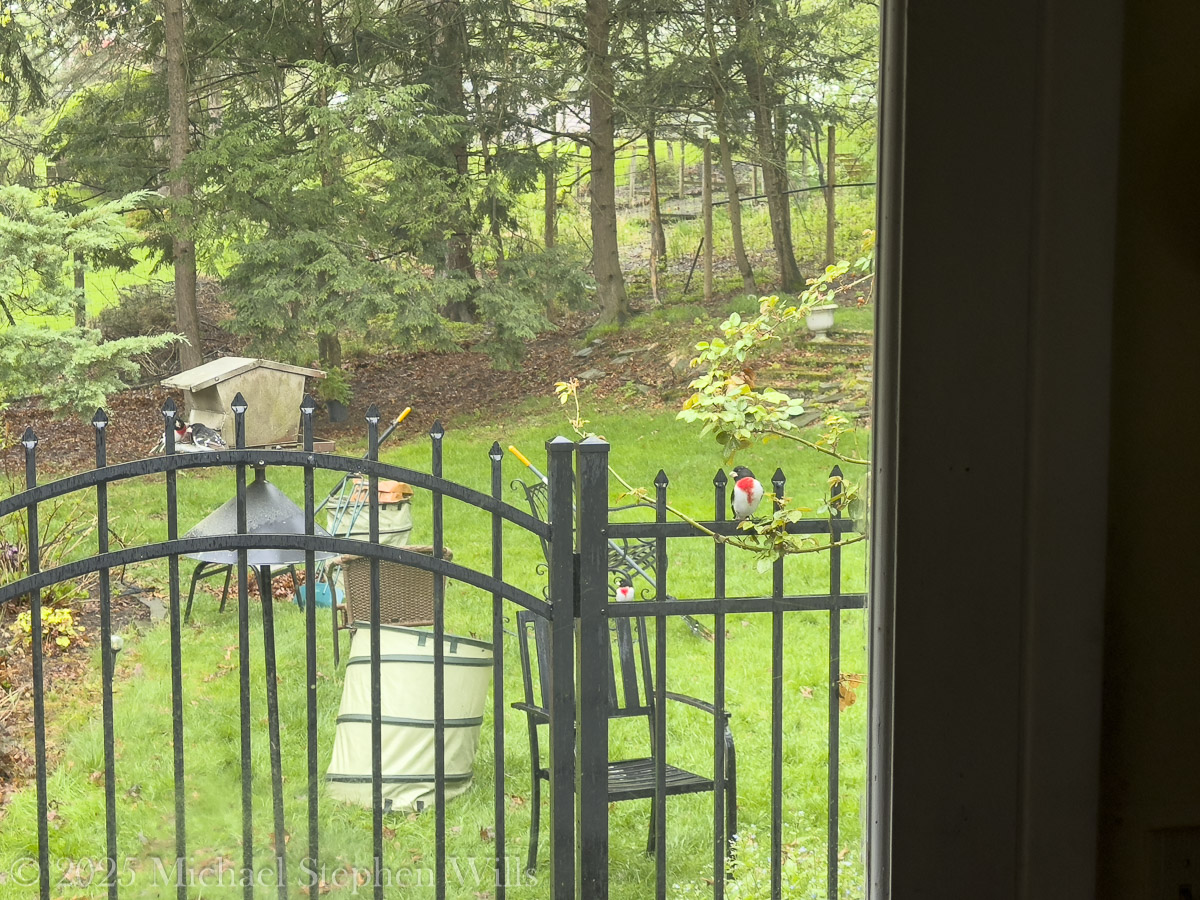
It was a gentle May morning, the kind that seems to hush even the wind, as though nature were holding its breath for something wonderful. Through the kitchen window, just past the black iron gate entwined with the fresh green of climbing rose, I spotted them—feathered heralds of spring’s deepening promise—perched like jeweled notes on a musical staff.
The Rose-breasted Grosbeaks had arrived.
May 3, 2025 Four Male Rose Brested Grosbeaks visited our backyard bird feeder during spring cleanup.
Not one or two, but a small flock, draped in raindrops, feathered in contrast and charm. They gathered around our backyard feeder like guests invited to a familiar table. At 5:56 a.m., the camera captured the first image: two males on the feeder and one each on fence and chair, a bold bib of crimson splashed across snowy chests, huddled against the gray of the feeder, their plumage brilliant even in the diffused dawn light. I couldn’t help but smile. This was a scene of quiet splendor, a symphony for the eyes and soul.
The males, unmistakable in their attire, wore tuxedos of black and white, with the defining rose-red marking on the breast that gives the species its common name. Their scientific name, Pheucticus ludovicianus, is less poetic but equally telling. “Pheucticus” comes from the Greek pheuktikos, meaning “shy” or “avoiding,” reflecting their reclusive habits in forested nesting grounds. “Ludovicianus” refers to Louisiana, an early French colonial name for a vast region including their breeding range—a nod to their North American roots.
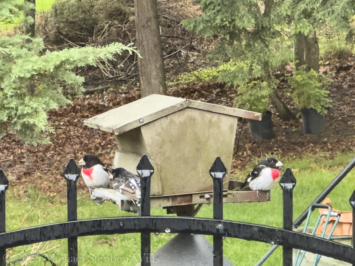
At 5:58 a.m., the lens captured more details: a male with slightly mottled wing feathers, suggesting he was a younger bird, still dressing up in adult finery. The trio clung to the feeder’s edge, their heavy, conical beaks—perfect for cracking seeds—clearly visible. That oversized bill gives them the name “grosbeak,” from the French gros bec, literally “large beak.” Functional beauty, you might say.
May 3, 2025 Three of the Four Male Rose Brested Grosbeaks visited our backyard bird feeder during spring cleanup.
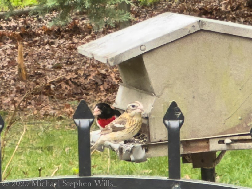
Then, at 6:08 a.m., came the contrast—the female. Subtly adorned in warm browns, with creamy streaks and a wash of yellow near the wings, she perched beside her flamboyant mate, as if to say: elegance need not shout. The two birds looked momentarily toward each other, and I was struck by their balance—his flair and her grace. Her eyebrow stripe, called a supercilium, lent her a composed, alert expression. While the male might catch the eye, the female commands attention in her own, quieter way.
May 3, 2025 Male and Female Rose Breasted Grosbeaks visited our backyard bird feeder during spring cleanup.
Rose-breasted Grosbeaks are migratory, long-distance travelers who winter in Central and South America and return each spring to North America’s deciduous and mixed woodlands to breed. Here in upstate New York, our yard is a brief rest stop on their northward journey—or, if I’m lucky, a summer home. They often nest in dense foliage, and their song, a melodic, whistled warble—like a robin who’s taken voice lessons—is often the first clue to their presence.
This morning, no song was needed. Their silent presence was enough.
Watching them, I felt time slow, the kind of moment when the ordinary yard becomes cathedral. Watching them, I felt time slow, the kind of moment when the ordinary yard becomes cathedral. The wet fence and chair under the feeder, even the crumpled leaf bag—everything was blessed by the company of these birds. Rain softened the world, and the birds brought color to its hush.
Later that day, reviewing the photos with metadata timestamps from my iPhone—each image like a verse in a poem—I marveled at what I had witnessed. These weren’t just birds. They were stories in flight, living punctuation marks in the sentence of my morning.
Nature gives us these moments, brief as birdsong and just as sweet. You only have to be still, and ready to receive them.
Enter your email to receive notification of future postings. I will not sell or share your email address.
Copyright 2025 All Rights Reserved Michael Stephen Wills
References
Pheucticus ludovicianus (Rose-breasted Grosbeak). Cornell Lab of Ornithology – All About Birds.
Jobling, James A. The Helm Dictionary of Scientific Bird Names. London: Christopher Helm, 2010.
Merriam-Webster Dictionary: Etymology of “Grosbeak.”
iPhone 14 Pro Max image metadata (May 3, 2025; 5:56 a.m. to 6:08 a.m.; Ithaca, NY).
Two men experience the breathtaking beauty and vastness of Monument Valley, reflecting on nature’s timelessness while feeling small against the grandeur of the landscape at dusk.
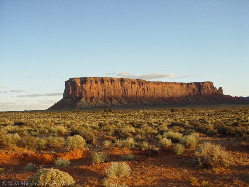
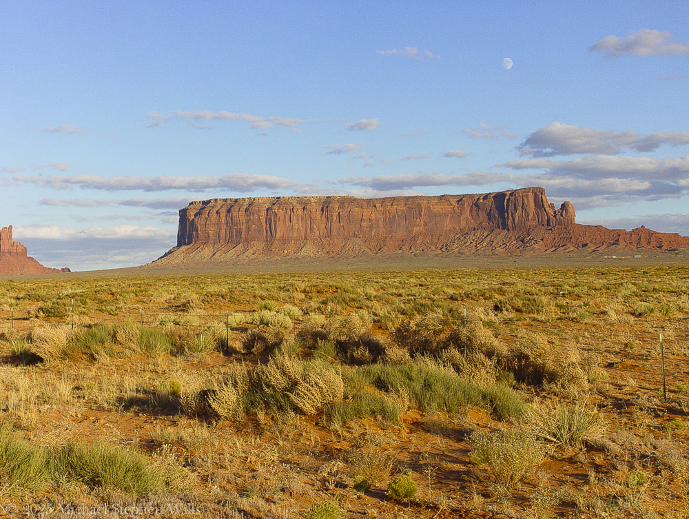
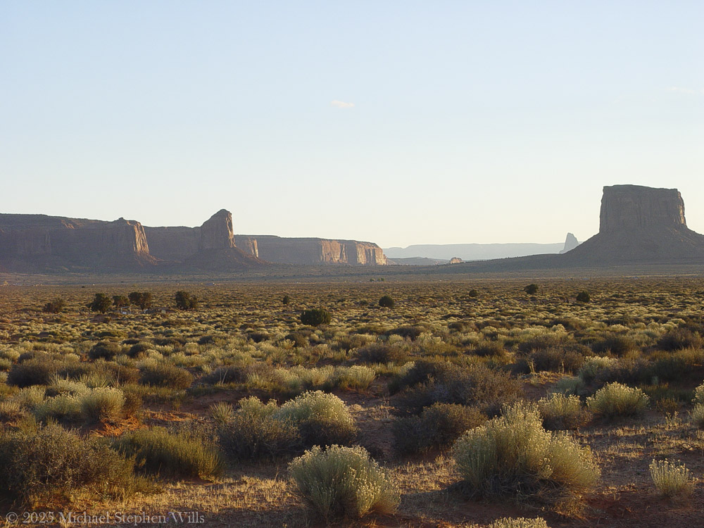
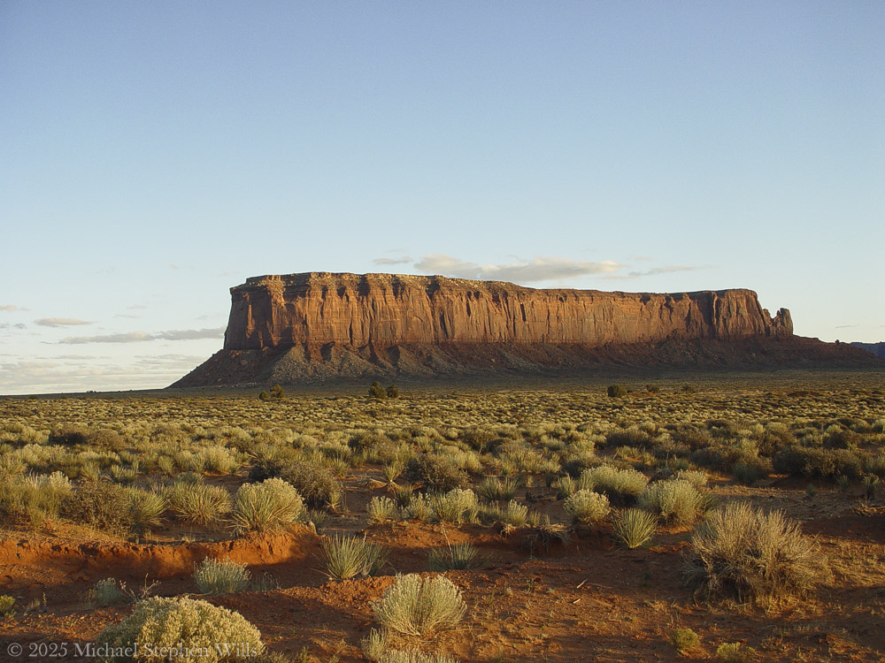
They drove on through the late November light with the road falling away toward the valley. In the west the sun hung low, a copper disk above the red land. The two men squinted through the windshield. Before them, Monument Valley unveiled itself in towering silhouettes and stone ramparts where the world opened to an ancient scene held in amber light. A long black ribbon of highway led onward, straight and true, toward those looming buttes etched against the sky. The older man eased the truck to the shoulder and killed the engine. In the newfound quiet, they sat as the wind ticked against the cooling hood. Ahead, the valley’s monuments stood waiting in the orange glow of sundown.
“Hell of a sight,” the driver said softly.
Sentinel Mesa and a slice of Big Indian peak to the left. A risen moon above all.As the day progressed here is Big Indian to the left, a portion of Sentinel Mesa with the risen moon above all
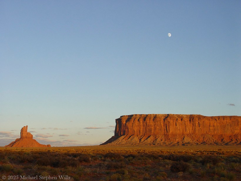
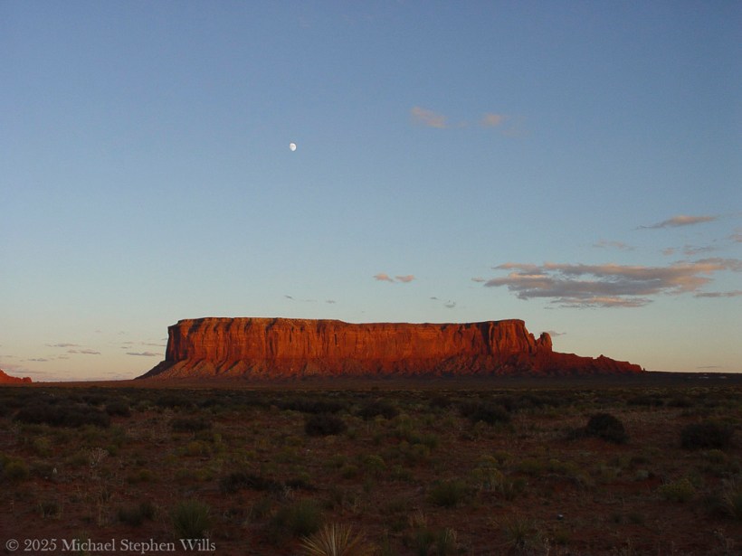
To the east, Sentinel Mesa rose broad and dark, its flat summit catching the last aureate light. The mesa loomed like a great natural battlement guarding the valley’s entrance. Aside, a solitary pinnacle known as the Big Indian stood in muted vermilion hues. In profile it did resemble a weathered face—a monumental visage gazing eternally south over the sacred lands. Farther south, Mitchell Butte jutted upward, its sheer walls burnished red-gold on one side where the sunlight still lingered. A mile or so southeast, the land climbed again to the massive bulk of Mitchell Mesa, now mostly in shadow. The sun was dropping behind it, outlining that mesa’s far rim in a halo of pale fire. Near to Mitchell Butte, a tall slender Gray Whiskers Butte rose like a lonely watchman. Its pinnacle was streaked with dusk, the stone fading from blood-red at its base to a somber gray at its crown. One of the men pointed toward it silently, and the other simply watched, understanding the unspoken thought: how small they were below these giants of rock.
Mitchell Butte, Grey Wiskers Butte and Mitchell Butte
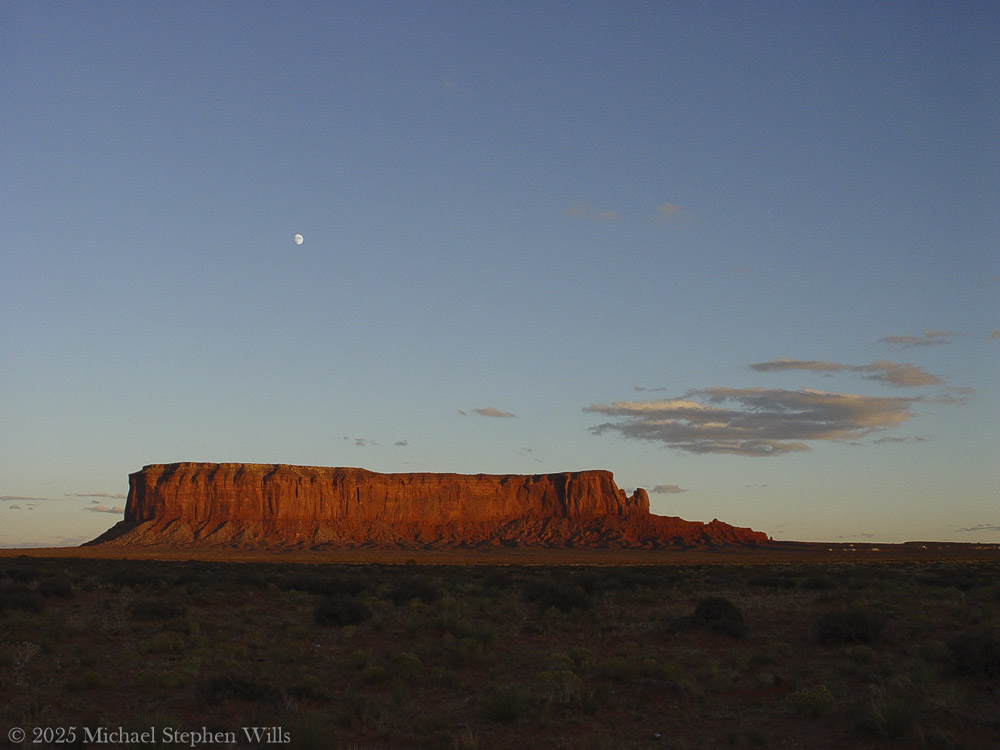
High above Sentinel Mesa, the evening swan of this desert had already appeared — a waxing moon, nearly full and ghostly white. It floated just over the mesa’s dark crown as twilight gathered, like an omen or a blessing. The sky behind the landforms had begun to take on the deep indigo of coming night. In the east, opposite the dying sun, the heavens were lavender and faintly banded with pink. The moon climbed in silence, gaining strength as the sun bled out in a final flare of vermilion along the horizon. In that half-light the mesas and buttes became blackened shapes, cut from the twilight itself, their identities merging with the land’s dusk. November’s chill crept in with the dark. The younger man drew his jacket closed. Neither of them had thought to speak for minutes now. They simply wandered a few yards from the truck, eyes turned outward and upward, silhouettes of their own against the dimming day.
Sentinel Mesa with risen moon
His companion nodded. He opened the door and stepped out. “Never seen anything like it,” the younger man said. His voice was reverent, almost a whisper. The driver climbed out too, boots crunching on red grit. They walked a few paces from the road, drawn forward as if on a tide. The evening air was cool and carried a dry, dusty scent tinged with sage. In the far distance, the monuments cast long blue shadows over the valley floor. The travelers stood for a long moment without speaking, each alone with the scale of it.
The land was vast and inscrutable. In the silence it felt holy. It was easy to believe no one else in the world existed at this hour — only these two and the ancient valley spread before them. The wind came from the west in a long sigh, carrying the dust of the desert. It whispered through dry bunches of brush at their feet and stirred a lonely tumbleweed across the cracked earth. The younger man removed his hat and ran a hand through his hair as if to assure himself this was real. The older man stood with thumbs hooked in his belt, head tilted back to drink in the view. His face was lined and still, the dying light painting one side in gentle umber. If either man harbored any burdens or regrets from the road behind, the land seemed to dwarf those worries into nothing. They felt themselves small as insects on an endless painted floor.
After a time, the driver cleared his throat. “We’ll lose the light soon,” he said. His voice was low. He seemed unwilling to break the spell with anything louder.
The younger man nodded again but did not take his eyes off the valley. “Just a few more minutes,” he replied.
“All right.” The driver smiled thinly and pulled out a cigarette. He struck a match and cupped it against the breeze, the brief flame reflecting in his narrowing eyes. In the glow of the match the canyons of his face showed for an instant, then vanished into shadow again. He drew in and exhaled a plume of smoke that the wind instantly seized and unraveled. Sentinel Mesa crouched out there like a great shadow, crowned now by a silver moon that grew brighter by the minute. The older man followed that mesa’s outline with his eyes, tracing the crenellated cliffs and the slope of rubble at its base. “They named that one right,” he said, mostly to himself.
“What’s that?” the other asked softly.
“Sentinel. Standing guard.” The driver gestured with the glowing tip of his cigarette. “Feels like it’s been watching this place forever.”
Sentinel Mesa standing guard with the red desert floor and fauna in the last light of sunset
The young man considered the hulking form of the mesa. In the twilight it did have the aspect of a watchtower keeping vigil over the valley. “It probably has,” he said. “Long before we ever came.”
On the road behind them a faint glint of chrome from the hood caught a stray moonbeam.
The younger man broke the long quiet. “You ever been down here before?”
The older man nodded. “A time or two.”
“You see all this then?”
A chuckle from the older man, low in his throat. “Not quite like this. First time I come through here I didn’t see a damn thing.”
The younger man looked over, puzzled. “What do you mean?”
“Well,” the old man said, “I’d been driving since Durango, and I’d run out of good sense somewhere near Shiprock. Rolled in with the rain. Thought I’d catch a nap and wake up to a postcard.”
He paused, lighting another cigarette, letting the flame flicker in the cooling breeze.
“Only I parked across from a big ridge in the moonless dead wet dark, didn’t think much of it. Woke up next morning to what I thought was the edge of a landfill. Just a big wall of brown rock. Figured I took a wrong turn and ended up behind a gas station.”
The young man laughed. “You’re kidding.”
“Nope. Got out, stretched, cursed the road and the view and the whole damn state. Got out to take a leak, figured I’d head on. And just as I’m zippering up, I look to the right—and there it is.”
He waved his hand toward the black outline of Mitchell Mesa, vast and solemn in the moonlight.
“The whole valley,” he said. “Caught me sideways. I parked blind to all of it. Missed the whole show.”
He shook his head, the cigarette ember glowing orange.
“Spent the next half hour cussing myself out. Sat there red-faced with a thermos of cold coffee like a man at the symphony who showed up deaf and late.”
The younger man laughed, full-throated now. “You mean to tell me you slept in Monument Valley and thought you were behind a gas station?”
The old man shrugged. “In my defense, it was cloudy.”
They both laughed then, the sound rolling out over the scrub and rocks and into the vastness.
He walked a little farther from the road, and the older man paced beside him. Ground crunching underfoot, fine dust kicking up around their boots. They ascended a slight rise where the terrain leveled off in a broad expanse leading toward the valley proper. Beneath their feet the earth was soft and powdery—red earth, lit now by the dim purple of dusk and the growing lunar light. The younger man scuffed the toe of his boot in it, and a little crimson cloud rose and drifted away. By daylight this soil was a vivid rust-red, the color of dried blood. It was as if the ground itself had a memory of violence or sorrow, but the truth of that color was simpler and older: the iron in the earth, left behind by ancient oceans, oxidizing over eons in the sun and airen.wikipedia.org. The land bled red because the very minerals of its making had rusted in the long passage of time. In places the valley floor was cracked clay, in others loose sand, all part of the same great story of stone turned to dust.
The two men walked out a bit further into the open, where scattered plants clung to life in the hardpan. There were low shrubs of sagebrush exuding a faint herbal scent, and clumps of purple sage with gray-green leaves, their summer blooms long spent. Here and there jutted the spiky forms of yucca, bayonet-tipped leaves fanning out from the base of each plant. Most everything that grew here hugged the ground and wore the dusty colors of the soil. In the failing light, the sage and grass tuft looked almost colorless, pale as ash. Only when lightning storms rolled through would the desert briefly bloom green; in these dry weeks of autumn the vegetation lay dormant, patient. A scraggly juniper tree crouched in a shallow gully nearby, twisted by wind and drought, its bark bleached where it faced the sun. These were the survivors of an unforgiving climate – rabbitbrush, snakeweed, hardy shrubs that lived on almost nothing. The young man knelt and pinched a bit of sage between his fingers, releasing its sharp fragrance. This smell, to him, was the perfume of the desert itself.
In the sand at the base of the sagebrush, he noticed a faint track. He brushed aside some dust to reveal the imprint of tiny claws: the delicate spoor of a lizard that had passed earlier when the ground was warm. It wound off between the rocks and vanished. Other tracks crisscrossed subtly in the dirt – a jackrabbit’s long-toed prints, nearly indistinguishable amid scuffs, and the delicate imprints of some small bird that had hopped about pecking for seeds. Life was here, though it was seldom seen. A red-tailed hawk wheeled silently high above, cutting black circles into the dim sky. Perhaps it was hunting one last time before full dark. The younger man stood again and looked out over the valley with new wonder, realizing that countless creatures lived and moved in this terrain largely unseen. In the daytime heat they sheltered in burrows and shadow. At dusk they came forth. He imagined a coyote trotting through a distant wash on soft paws, nose to the ground; a mule deer picking its way among these rocks somewhere beyond sight; a mountain lion watching from high up on a ledge as it had watched all afternoon. This desert did not easily give up its secrets, but they were there.
The older man stepped out onto a broad flat of rock and ground his cigarette butt under his heel. In the silence his companion could hear the scrape of boot leather on stone. The rock was part of an exposed slab that had broken off from a greater outcrop. It sloped gently down into the valley and was strewn with fine gravel from its own slow decay. The driver pressed his bootsole into a brittle crust of the rock’s surface, and it crumbled with a dry sound. These monoliths around them were not as immutable as they looked. Wind and rain had been gnawing at them for ages uncounted. Every thunderstorm that swept these flats cut new gullies in the shale, undercutting the bases of the cliffs. Every hot summer day the rock expanded, and every cold night it contracted, fissures growing by imperceptible degrees. Water trickled into cracks and ice pried them wider in winter. In time, great slabs would calve off with a roar and a billow of red dust, adding another heap of boulders to the talus at a butte’s feet. The valley was strewn with such piles like fallen ramparts. Erosion was the master sculptor here, patient and inexorable, chewing away the softer rock beneath and leaving the harder stone standing in great towers and tablelands. Each butte, each spire, had endured unthinkable ages to remain in this moment as a seemingly permanent fixture—and yet they too were slowly disappearing grain by grain. In a thousand years the difference might be subtle; in a million, perhaps these forms would be gone entirely, ground down to the flatness of the surrounding plain. The land was alive in geological time, though to human eyes it appeared frozen in a grand and silent repose.
They wandered farther, and now the truck was a small shape behind them on the roadside pullout. Neither man minded. The road was empty; no other vehicle had come along for a while, and only a lone set of headlights glimmered many miles away, moving slowly, probably a rancher or a late tourist heading home. The two travelers were alone with the land and sky. Overhead, the first stars were coming out in earnest, timid specks appearing in the dome of night. The moon was higher now and bright enough to cast shadows. The tall profile of Big Indian was cut into the moonlit sky, unmistakable and solemn, and on the valley floor the leaning spire of Gray Whiskers stood lit on one side by the cold glow. Away to the east, the open desert beyond the valley was falling into darkness, a great stretch of unknown country into which the highway disappeared. And still the west flared with afterlight — a band of deep red on the horizon, fading to gold, then greenish and up into the endless blue-black. It was a sky that seemed too vast for the world.
The younger man found a boulder at the edge of the flat and sat down. He removed his hat and set it beside him. The stone felt cool now under his legs. The heat of the day had fled so quickly that the air itself seemed to crackle with cold. He drew a deep breath and let it out. The land gave back only silence. A great and ageless solitude reigned here, the kind that makes its home in deserts and high places where man has no authority. He could feel it pressing in, not unkindly. It was the solitude of a world largely unchanged long before humans and likely long after. Under that eternal sky and the gaze of those stony sentinels, their own lives felt momentarily trivial. Yet the feeling was not bitterness or despair. Rather, it was humbling and strangely reassuring, as if all the griefs and triumphs that had ever marked a human life were nothing next to the calm presence of these rocks. The earth endured. The earth would always endure. Time and wind would wear down even mountains, but until then these mesas would keep witness over the days and nights, the storms and still mornings, the generations of men who came wandering through seeking something larger than themselves.
The older man walked over and eased himself down on the same boulder. He groaned softly as he sat, rubbing one knee. They both looked out over the emerging night. For a long while, neither spoke. Far in the distance, a coyote yipped — a brief, high sound, then silence again. The younger man smiled in the dark.
“The cold is coming fast,” the older man said after a time.
“Yeah. It does that quick out here.” He picked up his hat and dusted it off, though no dust truly could be kept off in this country. Dust was the true sovereign of the valley — red dust that coated boots and clothes, that hung in the air at midday, that settled on skin like a fine powder. It would ride back with them in their vehicle no matter how well they shook their coats. It had a way of clinging on, a reminder of where one had been.
“You ready?” with a tilt of his head back toward the truck.
The younger man took one last sweeping look over Monument Valley. The forms of Sentinel Mesa and its neighbors were nearly indistinguishable from the dark of the sky now, save where the moonlight etched a line or two along a cliff. The valley floor was lost in shadow. In the east, a few scattered clouds caught a faint silver luminescence from the risen moon. The beauty of the scene was stark and almost aching — a kind of beautiful emptiness that a man carries away inside him, knowing he has witnessed something that can never properly be told. He opened his mouth as if to speak, but no words came. Instead, he simply nodded and got to his feet. They began walking back toward the truck, side by side.
Behind them, the desert night continued its slow unfurling. One by one, stars pierced the darkness. The moon climbed higher on its silent arc. The great stone silhouettes stood unchanged, as they had through countless nights. In a few hours the dawn would come and paint them in rose and gold once more. But for now the valley slumbered under the pale glow of the moon. As the two men reached their vehicle and the engine turned over, its headlights flaring to life, they took one last look across the plains of Monument Valley. Then the truck pulled back onto the highway and receded down the lonesome ribbon of asphalt, two red taillights diminishing and finally vanishing into the boundless Navajo night. The land remained as it was, vast and indifferent to their departure. Sentinel Mesa and Mitchell Mesa stood like opposing pillars at the great gateway of the valley, keeping their eternal watch. The wind sighed over the road and across the sleeping rocks. The footprints the men had left were already beginning to blur with settling dust. Above, the indifferent stars traveled their courses. And the red earth of the desert stretched away in all directions—ancient, patient, and still, beneath the enduring sky.
Enter your email to receive notification of future postings. I will not sell or share your email address.
Copyright 2025 All Rights Reserved Michael Stephen Wills
The Louisa Duemling Meadows celebrate conservation and biodiversity, showcasing vibrant flora and honoring Louisa Duemling’s legacy as a steward of nature.
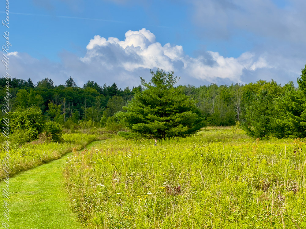
The Louisa Duemling Meadows, nestled within the expansive embrace of Sapsucker Woods, offers a vibrant tableau of life, brimming with opportunities for exploration and a sense of wonder. This new trail, winding through golden fields and punctuated by bursts of wildflowers, whispers tales of the land’s natural and cultural heritage.
Louisa Duemling: A Steward of Nature Louisa Duemling, the meadows’ namesake, was a dedicated conservationist and philanthropist who supported the Cornell Lab of Ornithology’s mission to protect birds and their habitats. Her legacy lives on in these serene fields, where her commitment to preserving the environment is reflected in every thriving plant and songbird.
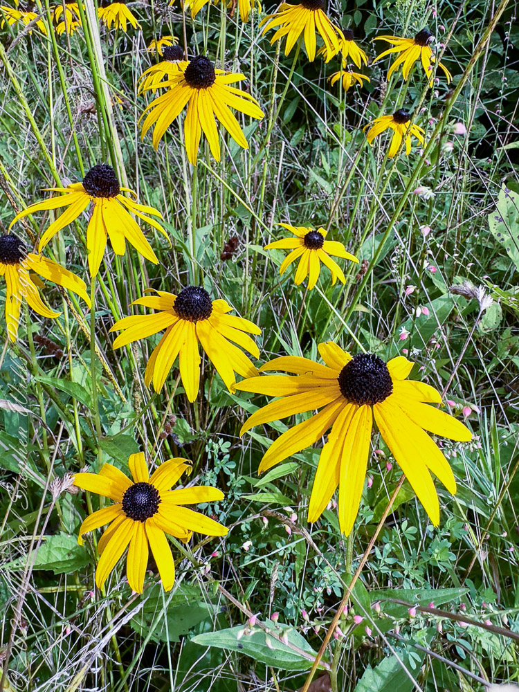
Black-eyed Susans: The Meadow’s Golden Treasure Dominating this summertime landscape with their radiant yellow petals and dark central disks, Black-eyed Susans (Rudbeckia hirta) are a hallmark of the meadows. These cheerful blooms are a delight to the eye, a cornerstone of meadow ecosystems. As members of the Asteraceae family, their composite flowers serve as a rich nectar source for pollinators like bees and butterflies, ensuring the vibrancy of these fields.
Historically, Black-eyed Susans have been used in traditional medicine by Native American tribes for their putative anti-inflammatory properties. Their ability to thrive in diverse conditions also makes them a symbol of resilience and adaptability.
A Symphony of Green and Gold Walking through the trail, one is greeted by the harmonious interplay of goldenrods (Solidago spp.), milkweeds (Asclepias spp.), and asters (Symphyotrichum spp.). Goldenrods, with their feathery clusters of yellow blooms, are often mistaken as allergenic culprits, though it is the inconspicuous ragweed (Ambrosia artemisiifolia) that deserves this reputation. Milkweeds, with their milky sap and delicate pink or white flowers, are vital to monarch butterflies (Danaus plexippus), serving as the sole food source for their larvae.
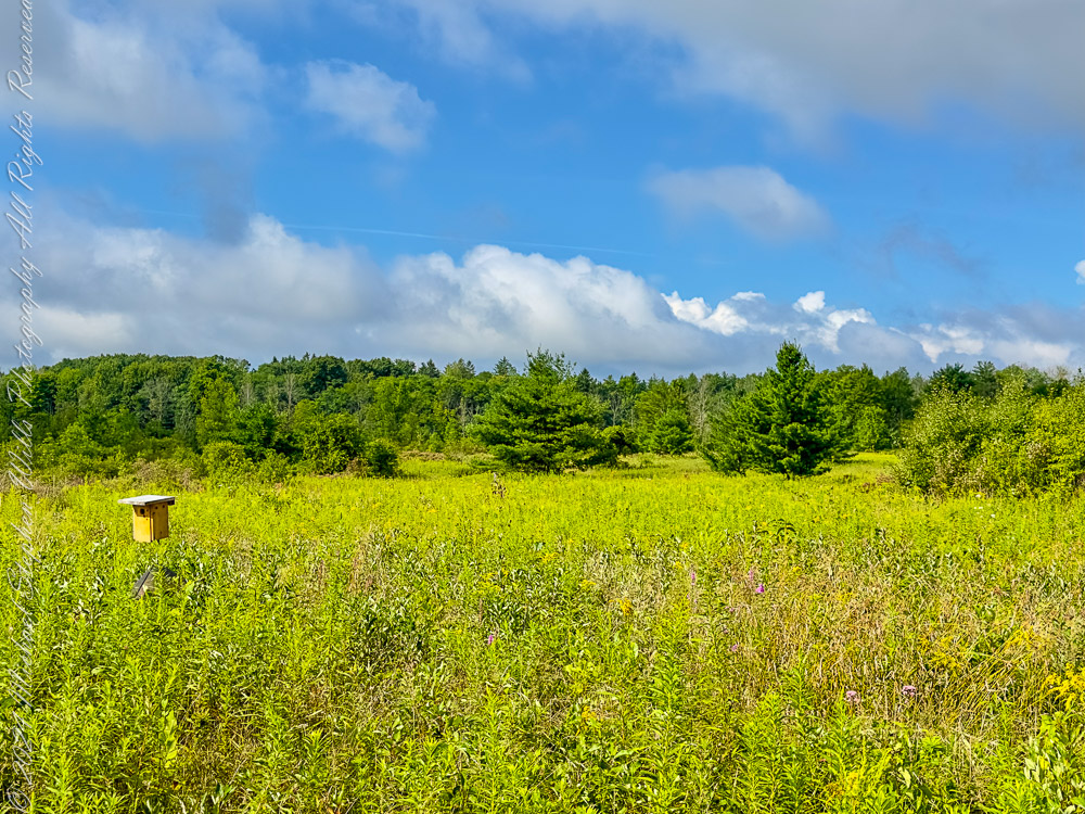
Among these botanical wonders, the birdhouse stands as a sentinel, a reminder of the intricate relationship between flora and fauna. These wooden structures provide safe havens for cavity-nesting birds like Eastern Bluebirds (Sialia sialis) and Tree Swallows (Tachycineta bicolor), fostering biodiversity within the meadow.
A Horizon Framed by Pines and Clouds The open meadow trails, flanked by clusters of Eastern White Pines (Pinus strobus) and punctuated by the azure sky, invite reflection and renewal. This is a place where the human spirit can align with the rhythms of nature, where each step reveals new layers of beauty and discovery.
Embracing the Spirit of Discovery To wander the Louisa Duemling Meadows is to immerse oneself in the timeless dance of life. The trail, carefully marked yet wild in essence, invites visitors to lose themselves in its beauty while finding solace in its quietude. This is not just a path through nature—it is a journey into the heart of conservation and a celebration of the life that thrives under Louisa Duemling’s enduring legacy.
As you leave the meadow, carry with you not just the memory of golden flowers and vibrant skies but the inspiration to cherish and protect the natural world. The Louisa Duemling Meadows are not only a gift to those who walk its trails but a reminder of the profound impact one can have in preserving our planet’s fragile beauty.
Enter your email to receive notification of future postings. I will not sell or share your email address.
Copyright 2025 All Rights Reserved Michael Stephen Wills