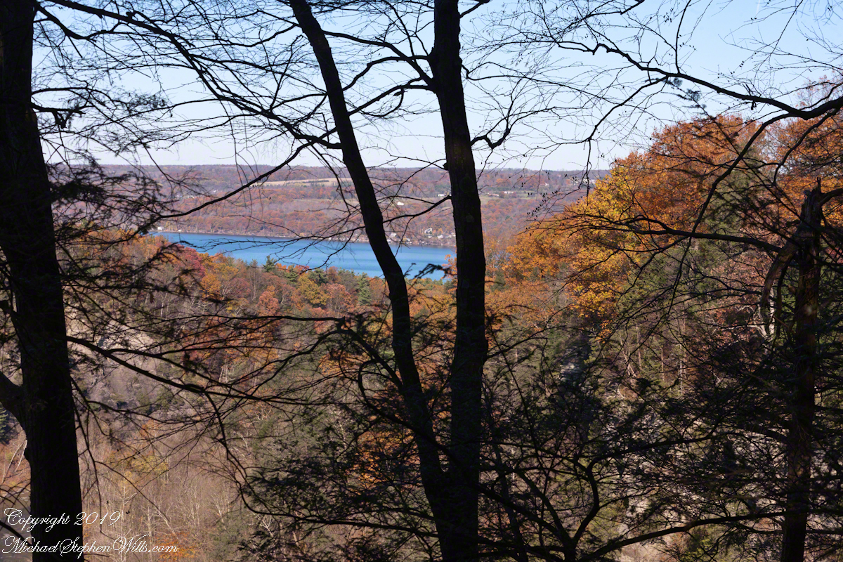
From a modest bench above Taughannock Gorge, Cayuga Lake shifts from distant glimmer to presence—a quiet invitation to pause, breathe, and follow the water down.
From the south rim of Taughannock Gorge, Cayuga Lake appears like a distant strip of sapphire, framed today by a soft veil of hemlock and oak. The overlook here is modest—a fence, a bit of open sky—but someone wisely added a comfortable bench, an invitation to pause between gorge and lake, rock and water.
I stood in front of that bench, resting the camera body on the fence, fingers braced against the wood to steady the shot. This is not the grand, sweeping vista of a postcard. Instead, it is a quieter, more human vantage point, the way a person actually encounters the lake after walking the rim: emerging from the trees, breath easing, eyes adjusting to the light on water.
From here, the trail descends toward Cayuga’s shore, each turn bringing you lower and closer, trading the lofty perspective for the intimate sounds of waves and stone. In Distant Sapphire I and II, the lake was a glimpse—caught between branches, distant beyond the gorge. Now, in this “Bench View,” the water feels nearer, almost within reach, as though the landscape itself is drawing you gently down.
Click photograph for a larger view. To do this from WordPress Reader, you need to first click the title of this post to open a new page.
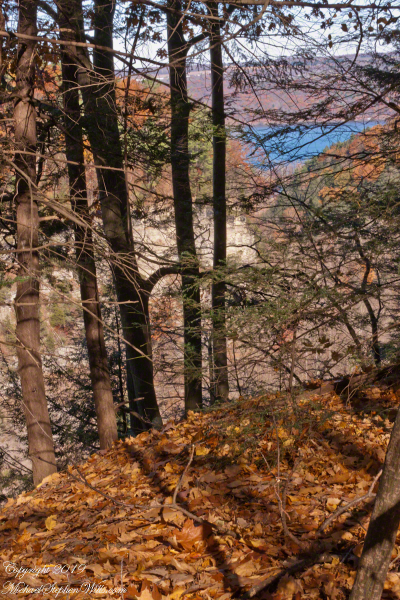
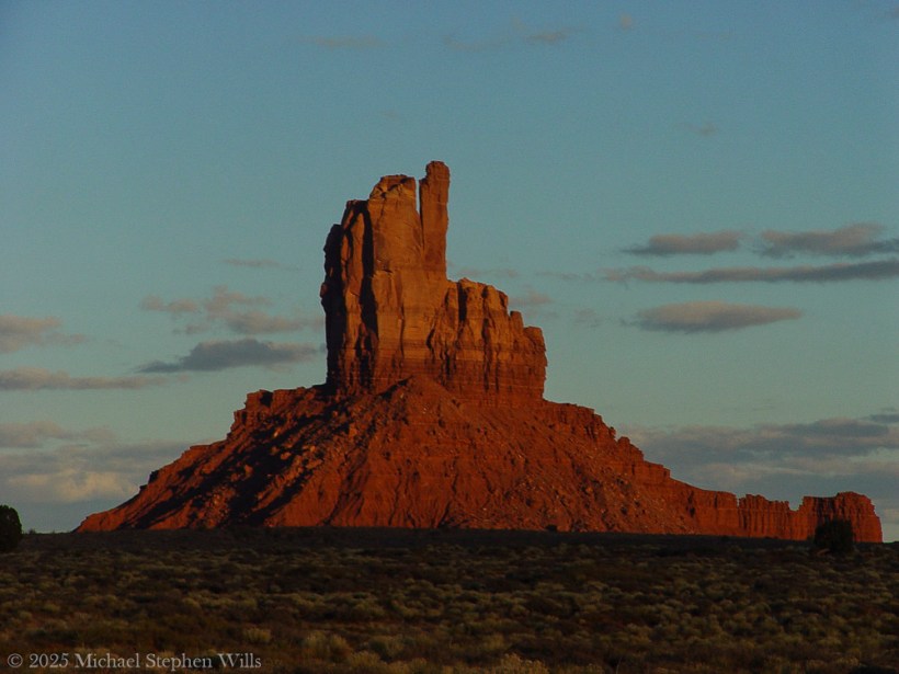
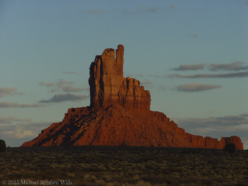
Cayuga Lake Bench View
I’ve gathered the three photographs—Glimpse of Cayuga Lake, Gorge View with Oak Leaves, and this Cayuga Lake Bench View—into a small gallery, a progression of approach. Each frame is a step closer: from suggestion, to invitation, to the quiet promise of the bench, waiting for whoever needs to sit and look a little longer.
A gallery of the three Cayuga Lake photographs for comparison.
Glimpse of Cayuga LakeGorge View with Oak LeavesCayuga Lake Bench View
Enter your email to receive notification of future postings. I will not sell or share your email address.
Copyright 2025 All Rights Reserved Michael Stephen Wills
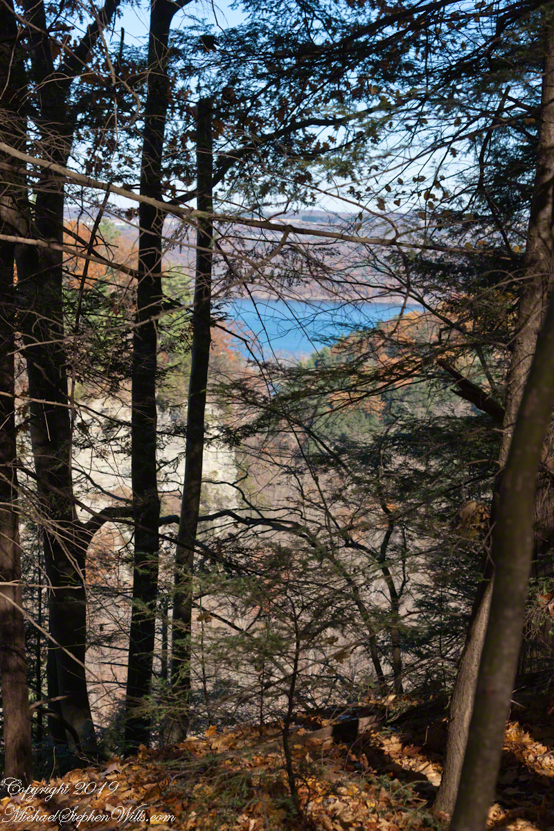
Cayuga Lake from the south rim of Taughannock Gorge, seen through a veil of hemlock with a carpet of fallen oak leaves, foreground. This is a companion to the previous post, both were handheld. For this the foreground was included to increase interest. For added stability, I rested the camera body on the fence bracketed with my fingers.
Click photograph for a larger view. To do this from WordPress Reader, you need to first click the title of this post to open a new page.
Gorge View with Oak Leaves
A gallery of the two photographs for comparison.
Glimpse of Cayuga LakeGorge View with Oak Leaves
Enter your email to receive notification of future postings. I will not sell or share your email address.
Copyright 2025 All Rights Reserved Michael Stephen Wills
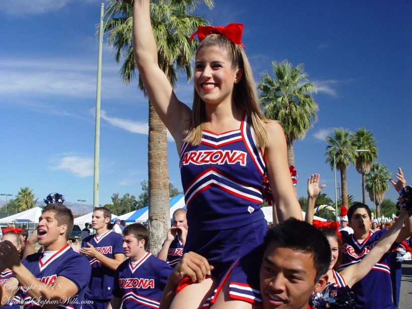
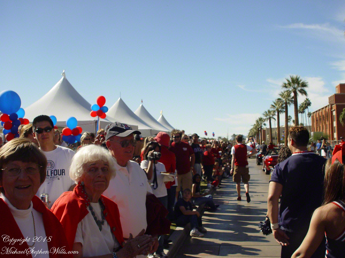
In November 2003, at fifty and traveling Arizona with my son Sean, I returned to the University of Arizona for my first Homecoming since graduating in 1975. I’d made the freshman cheerleading squad my first year in Tucson, and when the alumni invitation arrived, I couldn’t resist.
At the cheer alumni reception on November 7, the room felt instantly familiar—handshakes, stories, and a current squad packed with scholars as well as athletes. I mentioned to advisor Phoebe Chalk that I hoped to photograph the parade. “The squad already had photographers”, she said, so I planned to work from the sidelines.
I came prepared the next day with a Sony Cybershot F828. It was “Sony’s flagship prosumer digital camera” at the time. It worked well that day, the variable lens was especially helpful.
At the staging site, I solved access with a simple ask. I approached UA President Peter Likins, explained I wanted to photograph the cheerleaders, and he nodded, made a quick call, and waved me on. The team recognized me from the evening before, and I fell in step with them at the head of the procession
As we passed the Flandrau Science Center and crossed Cherry Avenue, a stunt group set quickly: bases J. Justin VandenBerg, Ricardo Abud (captain), and Robert Scoby with flyer Taylor Hendrickson. They launched her high for a full flip and clean catch. I caught the moment of collective focus—an image I call Mind.
We progressed until the stunt group reset. This time I framed the instant of takeoff—limbs aligned like clockwork—I call this image Aerialists.
The next flyer to launch was Kristen Ortega, here standing on the shoulders of her partner.
In front of the review stand, flyer Kristen Ortega rose into a poised extension and flight returned safely to the same three pairs of hands. Grace is the image title.
The rest of the parade streamed past in a blur of alumni, bands, and banners. Afterward, a squad member took a picture of me with the team—two eras in one frame. The cheers change; the spirit doesn’t.
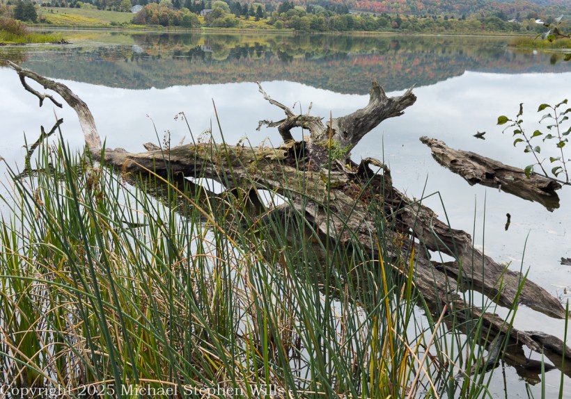
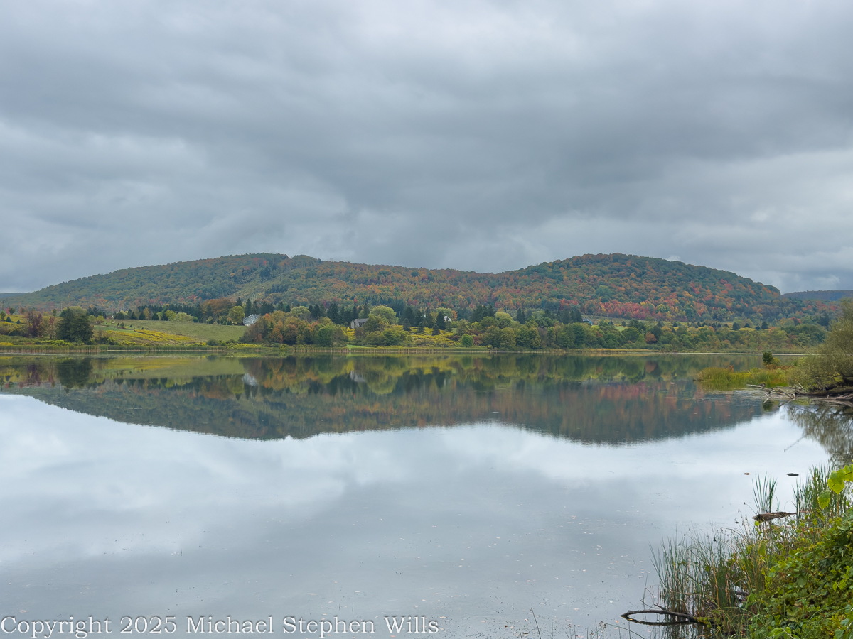
Morning clouds hang over Dryden Lake as hills kindle first color; reflections hold breath while a lone walker reads the valley’s glacial and human-written past.
He came to the water before the people woke, the road a still ribbon of cold tar snaking beneath the low hills. Mattocks of cloud hung over the valley and the lake took in the sky like a mirror dropped yet not broken. The trees were beginning to color. A patient fire working from within the leaves. He parked where the grass ran down to the shore and stood a long while without moving. Birds made small sounds in the reeds. Somewhere a single truck labored up the grade and was gone. The surface held the hills with a steadiness the hills themselves could not keep. He thought how the quiet of a place can be the loudest thing it owns.
He went along the margin along the damp sedges where old drift lay silvered and light as bones. A drowned trunk angled from the shallows. The lake was old in the way of things made by ice and time. A kettle in the outwash of the last glacier, some men said, a bowl left when the buried ice eased away. He pictured the ice receding into the valley heads, the meltwaters choked with gravel, a hand larger than memory scribing the floor of this country. The earth never told it plain but the lay of it was witness enough. Across later centuries men cribbed a dam across the outlet and drew the water to a shape that pleased them and served their work.
A trail ran the length of the water on the old rail bed. The ties were long gone and the iron and cinders buried under years of leaf fall and gravel. He had walked it as a boy beside his father and now he walked it alone. Benches stood at half-mile intervals like waystations in a country of small pilgrimages. The signs told what once was here and what remains. They had renamed the path for a townman who argued it into being after the railroad had passed from the world and the right-of-way grew up with sumac and rumor. It was an easy trail and he carried nothing. His hands hung at his sides as if the day might place something in them when it was ready.
In another era the lake was a workshop. Men whipsawed timber in the wet air and fed small mills with the grove’s dark boards. Winter flowed over the flats, and they built icehouses and set the blocks within like blue stone, an industry that died when cold could be called from a switch. The hills have learned to forget the noise of it, though on certain mornings the fog takes a shape and you could believe rising from the ponded sawdust and the lading of sleds. He thought of the labor of those gone hands and of how work is a scripture every place keeps in its own tongue.
Before any of that, the ground here was a summer camp. People came with the season and went with it, laying their fires in the lee of the knoll and taking fish where the cattails thin. He could feel them in the open places, not as ghosts but as the first understanding the land ever had of itself. The words used for them now are museum words, yet the wind still crosses the water as it did and empties the same smell of iron and leaf into the lungs of whoever stands to breathe.
The town took its name from a poet long dead, a scholar’s choosing in the years after the war for independence when this tract of country was parceled out to soldiers of that same war. Virgil lay to the east as if they were shelving Latin across a map. The creek that bears that name threads the villages and finds Fall Creek at Freeville, and the combined waters go their own slow way toward Cayuga where the glacial hand scooped deeper yet. He said these names under his breath and they tasted of chalk and river stone.
A kingfisher rattled across the cove. The fish rose in rings that spread and vanished like time seen from above. Out on the water an old man pushed a skiff with an electric motor that hummed like a trapped bee, for the lake allows no gas engines now. The wildlife area ran around the shore in a ragged collar of field and wetland and alder, near two hundred acres under the state’s keeping, and the lake itself a little over a hundred. He watched the man aim for the lily line and thought how rules arise from the wish that a thing endure, though nothing does. Still we make the rules and we keep them as if the earth were listening.
Wind came down the slope with a smell of rain. He turned back and the hills lay again in the water, entire, and for a moment he could not tell which world had claim to the other. He thought of the rails pulled up and the mills gone to weeds and of the icehouses fallen into their own shadows and he thought of the people before all that and of the long winter pressing its thumb into the land and lifting it away. He thought of his father walking the rail bed beside him a lifetime ago and saying nothing. There are places where the past crowds close and will not be argued with. He stood until the first drops dimpled the surface and the reflection shattered and reformed. A train no longer runs here. The only sound was the soft percussion of rain on water and the slow turning of the earth beneath both. He put his hand to the damp trunk of a fallen tree and felt the grain and the coolness and the old patient labor of rot. Then he went up from the reeds, his pockets full of acorns, and out to the road where his truck waited and the day, austere and sufficient, came along with him.
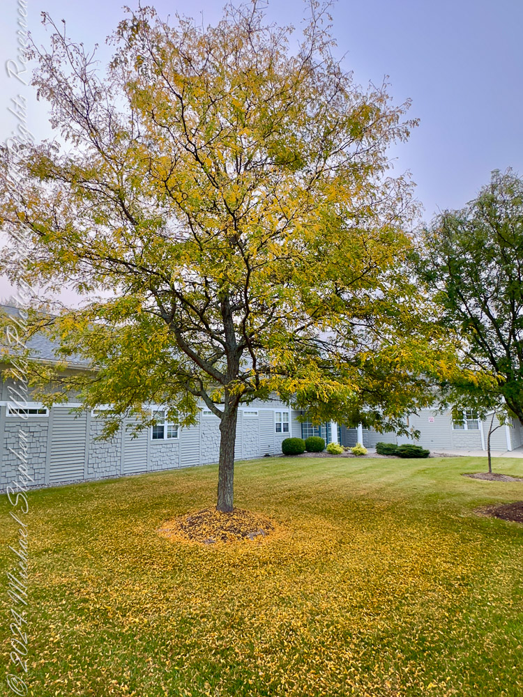
Standing before these two trees on a unseasonably warm autumn day, I am struck by the intricate patterns of their fallen leaves. Against the vibrant green of the grass, the golden leaves form halos around the trunks, as if nature herself were sketching mandalas. There’s something profoundly mathematical about these arrangements—a quiet order amidst what might initially seem like chaos.
The first tree, its barren branches reaching skyward, stands on a carpet of yellow that radiates outward in near-perfect symmetry. The leaves have fallen in such a way that their density decreases as the distance from the trunk increases. It reminds me of the inverse square law—a principle in physics that governs how light, gravity, and sound diminish with distance. Here, instead of energy dispersing, it’s the leaves thinning out, their graceful scatter dictated by the wind’s whims and gravity’s pull. There’s an undeniable harmony in this seemingly random process, a convergence of natural forces creating an elegant gradient.
Stewart Park, Ithaca, New York
The second tree presents a different story, yet one equally mesmerizing. Its leaves, still clinging in part to the branches, form a looser ring at the base. The distribution is uneven, hinting at prevailing winds or the sheltering influence of nearby buildings. But even in this asymmetry, I see fractals—the self-similar patterns that repeat at different scales throughout nature. Look closely, and you’ll notice clusters of leaves mimicking the broader structure of the canopy above. It’s as if the tree’s essence is echoed in the ground below, a reminder of how deeply interconnected every part of a system can be.
Robinia pseudoacacia, commonly known as the black locust
These patterns invite reflection on the mathematical principles governing our world. Fibonacci sequences, golden ratios, and fractals—abstract concepts are not confined to textbooks. They are etched into the fabric of existence, visible in the spiral of a sunflower’s seeds, the curve of a nautilus shell, and the fall of leaves beneath a tree. Even the chaos of autumn is underpinned by order, a dance choreographed by countless variables: the angle of the branches, the strength of the wind, the moisture in the air.
I find myself wondering about the unseen forces at play. How many leaves fell straight down, obeying only gravity? How many were carried aloft by a breeze before settling farther afield? Could we model these patterns with algorithms, tracing the arc of each leaf’s descent? Would the data reveal a perfect equation, or would it remind us that some mysteries resist full comprehension?
As I stand here, I feel a deep gratitude for these natural equations. They ground me in the present moment while also connecting me to the infinite. The pattern of leaf fall is a reminder of life’s balance: chaos and order, randomness and structure, fleeting moments and timeless principles. The trees, now shedding their golden crowns, invite me to pause, observe, and marvel at the beautiful mathematics of autumn.
Enter your email to receive notification of future postings. I will not sell or share your email address.
Copyright 2025 All Rights Reserved Michael Stephen Wills
On a serene autumn afternoon by Beebe Lake, a solitary red maple stood out against the backdrop, showcasing its vibrant colors and resilience, symbolizing autumn’s fleeting beauty.
It was one of those serene autumn afternoons that linger in memory, the kind where the sky seems impossibly clear, the air crisp and gently scented with fallen leaves. I stood at the edge of Beebe Lake, my gaze first drawn to the textured concrete dam holding back the water, its weathered facade contrasting sharply with the soft reflections shimmering across the lake’s calm surface. Beyond, the wooded hillside rose gently, a tapestry woven with the warm hues of autumn—golds, greens, oranges, and reds mingling like brush strokes on a canvas.
An October Glory, turning before all others
Yet amidst this collective beauty, one tree captured my attention, singular in its brilliance—a solitary red maple standing proudly on the lakeshore. Its leaves had turned a vivid crimson, blazing brightly as though defying the muted earth tones surrounding it. Even from a distance, framed and partially obscured by larger trees, its vibrant reflection cast a fiery echo on the water, rippling softly in the afternoon breeze.
The maple, Acer Rubrum, seemed perfectly at home here, thriving robustly at the water’s edge. I remembered reading how adaptable red maples are, able to flourish in conditions ranging from dry uplands to swampy shores. This spot, near the edge of the tranquil Beebe Lake, seemed to showcase its resilient character perfectly.
Up close, the maple’s glow was even more striking. Its leaves cascaded in fiery clusters, hues deepening from bright scarlet at the tips to a darker maroon closer to the branches. This dramatic gradient seemed symbolic of autumn itself—beautiful, fleeting, and subtly tinged with the melancholy reminder of winter’s approach.
The Red Maple (Acer Rubrum) to tolerant of diverse conditions, making it a perfect choice for this spot on the short of Beebe Lake.
A memory surfaced of early spring in the Finger Lakes region, a time when maples, including this red maple, generously share their sap. Though not traditionally tapped like its sweeter cousin, the sugar maple, this species’ sap can indeed be boiled down into syrup, a surprising sweetness hidden within its sturdy trunk. Standing in its shadow, imagining those early spring days, it seemed astonishing that the same tree could offer both the delicate sweetness of syrup and the fierce beauty now on display.
Curiously, the transformation of the tree appeared methodical yet whimsical—it changed colors from the top down, its upper branches already bare, exposing slender twigs pointing skyward. Like an artist carefully removing layers to reveal something deeper beneath, the maple unveiled its upper bare bones first, as though reminding observers of the quiet strength supporting its autumn splendor.
This Red Maple (Acer Rubrum) turns from the top down and has already bare for most top branches.
As I lingered, taking in this turning tree, joggers passed by along the path, their rhythmic footsteps a gentle percussion beneath the rustling leaves. Briefly, they glanced toward the vivid maple, perhaps drawn, like me, by its striking contrast to the surrounding foliage. It felt like we shared a secret admiration for this singular tree, recognizing in it a quiet assertion of individuality amidst conformity.
Eventually, I viewed the maple once more from afar, framed now by broader sweeps of branches and leaves, partially obscured but no less vivid. Through layers of leaves and dappled sunlight, it glowed like a distant flame, a beacon that seemed to encapsulate the entire mood of the season—warm yet cool, bright yet transient.
The Red Maple (Acer Rubrum) is the first to flower in spring and the first to turn in autumn.
Walking away, the image of that maple lingered, its reflection shimmering gently in the afternoon sun, a moment suspended between summer’s lush vitality and winter’s bare stillness. Beebe Lake had offered scenic beauty, a quiet meditation, a reflection mirrored not only on its tranquil surface but in the heart of an observer captivated by a single tree’s fleeting glory.
Enter your email to receive notification of future postings. I will not sell or share your email address.
Copyright 2025 All Rights Reserved Michael Stephen Wills
Monument Valley, or Tsé Biiʼ Ndzisgaii, embodies a profound connection between the Diné people and the land, contrasting imposed names with cultural significance and sacred narratives.
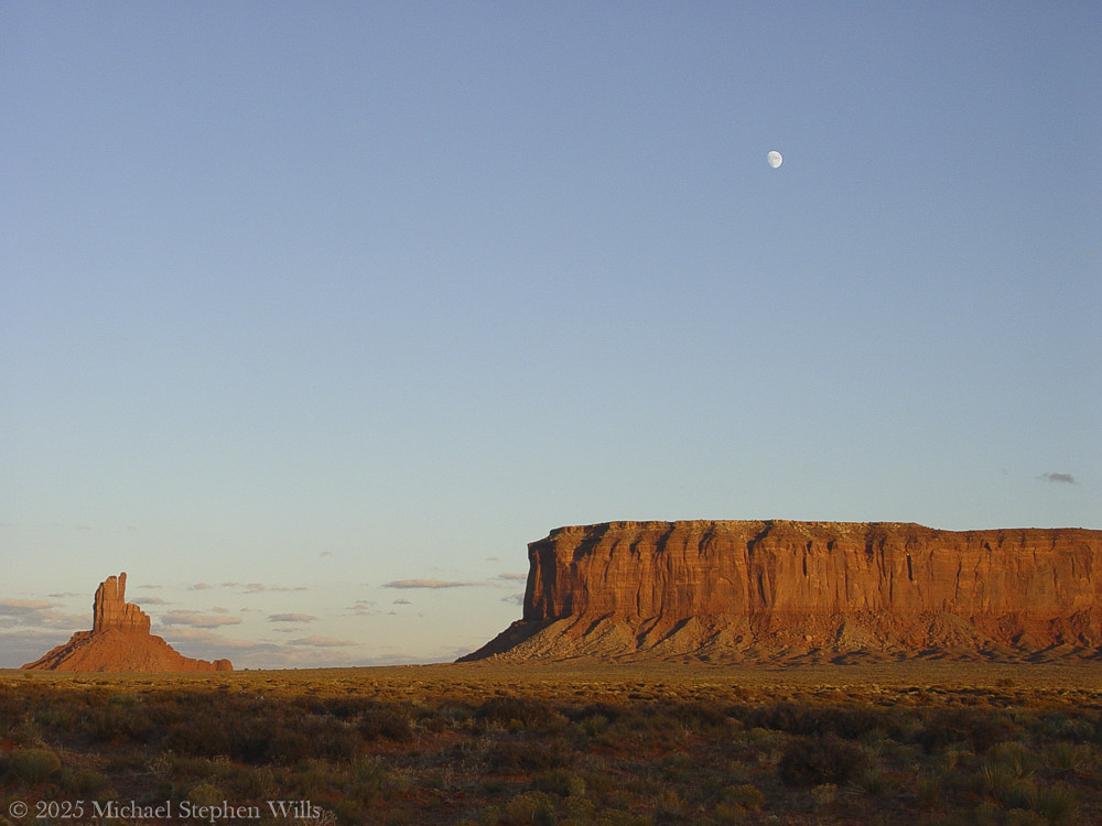
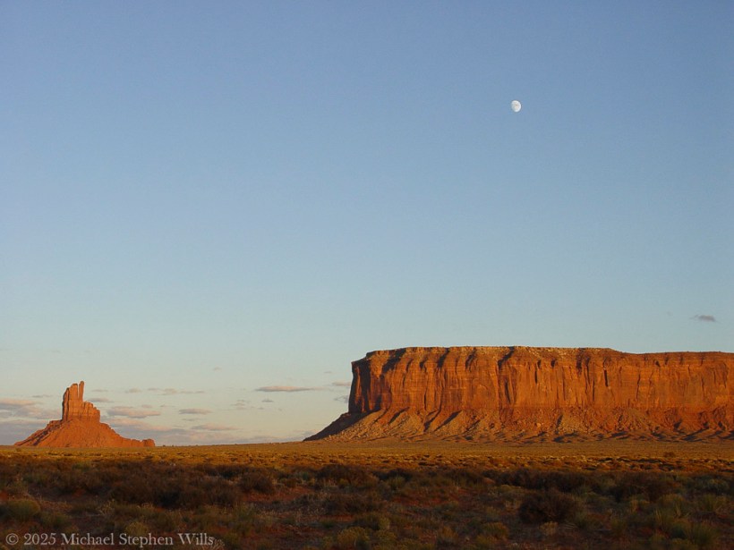
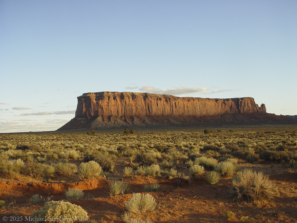
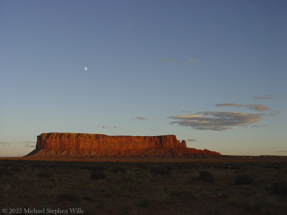
In the golden hush of this November sunset, Monument Valley stretches before us – an endless desert plain punctuated by towering red rock sentinels. The sky is vast and translucent blue, as a pale three-quarter moon rises silently above a solitary spire of sandstone. That spire is known on maps as Big Indian, a stone pillar glowing russet in the low sun. It stands apart from the mesas, its silhouette uncanny against the evening sky. In this serene moment, the land feels alive with presence. And the name “Big Indian” lingers in the air, raising quiet questions about what we call this place – and what it truly is.
From a distance, the spire does suggest a figure: tourists are told to squint, tilt their heads, and “see” the profile of a Native face gazing outward. One can imagine the first person to name it must’ve been a bored prospector, half-delirious from the heat after a lunch of canned beans, declaring: “I swear that rock looks like Uncle Joe in a feathered headdress.” And so the name stuck – a geological Rorschach test gone slightly colonial.
These whimsical titles – Totem Pole, Stagecoach, Big Indian – come not from the land, but from a long habit of outsiders labeling what they didn’t fully understand. “Big Indian” is particularly layered. The term “Indian” itself was born from Columbus’s navigational misfire, mistaking the Caribbean for Asia and its people for “Indios.” The Diné, the people who have lived here for centuries, never called themselves that. So this towering formation now bears the echo of a 15th-century directional blunder —like a name tag on the Sphinx that reads “Buckeye” because someone once thought Egypt was in Ohio. It’s a reminder: names given in haste can cling for centuries, even when they miss the mark entirely.
But beyond the names imposed by mapmakers, the spire simply is, in all its silent grandeur. In Diné lands, this valley has a different name: Tsé Biiʼ Ndzisgaii, often translated as Valley of the Rocks. In the Navajo tongue the name literally evokes “rock within white streaks around” – referring to the light bands of sediment that ring the red buttes. Those pale streaks wrap the spire like faded paint, remnants of ancient layers of earth. Here the Diné language whispers a description born of the land itself, unlike the English names that often project an outsider’s story. Tsé Biiʼ Ndzisgaii speaks to the truth of the place: stone and light, strata and shadow. As the sun lowers, you can actually see those whitish bands catching the last glow, encircling the butte like old memory. The Diné name honors what the eye sees – the layered geology – rather than imposing an unrelated label. This spire and its neighbors were not built by human hands, though their sheer stature can feel like architecture of the gods. Millions of years of natural artistry shaped Monument Valley.
Long before any person walked here, this land was a low basin collecting sediments. Layer upon layer of sand and silt hardened into rock, and a slow uplift in the earth heaved the basin into a plateau. Wind and water became patient sculptors over the last 50 million years, carving the plateau and peeling away the softer material. What remains today are the skeletal monuments of that erosion: buttes, mesas, and spires rising up to a thousand feet above the desert floor. Each is made of stratified stone – the broader bases of red shale and sandstone, and a cap of harder rock that resists the elements. Big Indian’s sturdy pedestal and slender crest tell this story of layered resilience. In the red-orange rock, oxides of iron tint the cliffs a deep rust, while streaks of black manganese oxide – “desert varnish” – trace down their sides like natural paint. Time and the elements have sculpted a masterpiece here.
Standing at its foot, one needs imagine the immeasurable ages of sun and storm that chiseled this lone tower from the earth. And yet, facts of geology alone fail to capture the spirit one feels in Tsé Biiʼ Ndzisgaii. The Diné know that spirit well – this valley is sacred to the Navajo Nation. To them, these colossal rocks are alive with meaning. The people have lived and wandered among these mesas for centuries, blessing the land with their stories and prayers.
In Navajo cosmology, the landscape itself is imbued with life and purpose. The buttes are often seen as ancestors, guardians, or holy figures watching over the People. For example, the famous twin buttes called the Mittens are said to be a pair of spiritual beings – one male, one female – forever facing each other across the valley, protecting and balancing the land. Another hulking mesa, Sentinel Mesa, is known as a “door post” of the valley, a guardian at the entrance, paired with another butte as the opposite door post. The valley, in the Diné way of seeing, resembles a great hogan, a home blessed by the gods: the mesas at its threshold are like the posts of a doorway, and a butte called The Hub is imagined as the central fire hearth of this immense home.
In this way, the Diné landscape is a living, storied environment. Even the spindly formations carry sacred narrative. Seven miles southeast from Big Indian stand slender pinnacles known to the Navajo as Yei Bi Chei, named for the masked spiritual dancers who emerge on the last night of a winter healing ceremony.
Each dawn, as the first light breaks over the mesas, it’s said the Navajo families come out of their hogans to greet the sun with prayers – their doorways always face the east to receive blessings of the day. In the same way, the great stone hogan of Monument Valley opens eastward, with its door-post buttes and its eternal fireplace. In Diné worldview, earth and sky are intertwined with their lives; they speak of Mother Earth from whom they emerged and to whom they owe care. Here in Monument Valley, it is possible to feel that harmony – the sense that every column of rock, every whispering juniper shrub, every beam of sunlight and moonrise is part of a whole living tapestry.
We watch as the moon climbs higher above the Big Indian spire, its silvery light softening the rock’s hard edges. This place has known many names and will outlast many more. The Paiute people who roamed here before called it “Valley Amid the Rocks” and wove myths of gods and giants into its features. Later came the labels of explorers and filmmakers: Monument Valley, a monumental canvas for Western legends. And of course, the simplistic tag Big Indian for this lone rock – a name that says more about those who coined it than about the land itself.
Names, in the end, are stories we tell about the world. The colonial names imposed here are like brief echoes across the ages, while the Diné stories run deep as the red earth. The Diné prefer to call themselves Diné – meaning “the People”– and they call this land by names that describe its true character. I imagine that to the People, this spire might be thought of not as an “Indian” at all, but perhaps as a sentinel or an old friend standing watch. Its Diné name, if it has one, would likely emerge from its form or its role in a story, spoken with reverence.
As dusk turns to twilight, an immense peace settles. The monolith before me is no longer just Big Indian on a map; it is an ancient entity shaped by time and honored by generations. In the silence, we can almost hear the land speaking in the old language – telling of how it was born from oceans and sand, how it saw the first people wander through, how it endures through centuries of memory. The rock shares with us a moment beyond names: just the whisper of wind, the glow of moon, and a feeling of connection and wonder. This is Monument Valley, Tsé Biiʼ Ndzisgaii, in all its truth. In this contemplative dusk, I bow to the tower of stone, misnamed yet never truly defined by that misnomer. It remains what it has always been – a creation of earth and spirit, a witness to history, a source of humble awe. Tuning to leave, I softly speak a word of thanks – Ahéheeʼ – grateful to have listened, if only briefly, to the sacred voice of the valley.
Bibliography
Encyclopædia Britannica – Tribal Nomenclature: American Indian, Native American, and First Nation britannica.com (origin of the term “Indian” as a colonial misnomer)
Navajo Nation Parks & Recreation – Monument Valley (Tsé Bii’ Ndzisgaii) navajonationparks.orgnavajonationparks.org (official site detailing Monument Valley’s geology and formation)
Robert S. McPherson – Monument Valley.Utah History Encyclopediauen.orguen.org (history, geology, and indigenous lore of Monument Valley)
Aztec Navajo County – Monument Valley PDF Guide aztecnm.comaztecnm.com (descriptions of formations, including Navajo perspectives on their meanings and names)
Navajo Word of the Day – Tsé Biiʼ Ndzisgaii navajowotd.com (explanation of the Navajo name for Monument Valley, meaning “white streaks in the rocks”)
Enter your email to receive notification of future postings. I will not sell or share your email address.
Copyright 2025 All Rights Reserved Michael Stephen Wills
Two men experience the breathtaking beauty and vastness of Monument Valley, reflecting on nature’s timelessness while feeling small against the grandeur of the landscape at dusk.
They drove on through the late November light with the road falling away toward the valley. In the west the sun hung low, a copper disk above the red land. The two men squinted through the windshield. Before them, Monument Valley unveiled itself in towering silhouettes and stone ramparts where the world opened to an ancient scene held in amber light. A long black ribbon of highway led onward, straight and true, toward those looming buttes etched against the sky. The older man eased the truck to the shoulder and killed the engine. In the newfound quiet, they sat as the wind ticked against the cooling hood. Ahead, the valley’s monuments stood waiting in the orange glow of sundown.
“Hell of a sight,” the driver said softly.
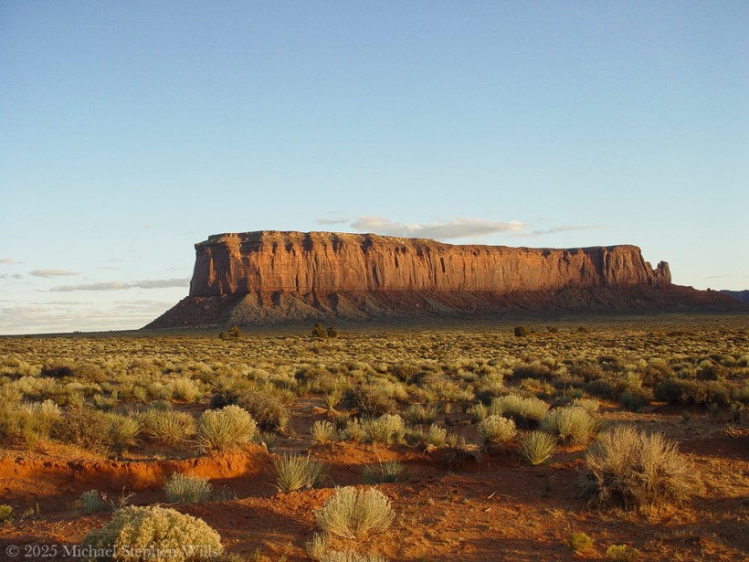
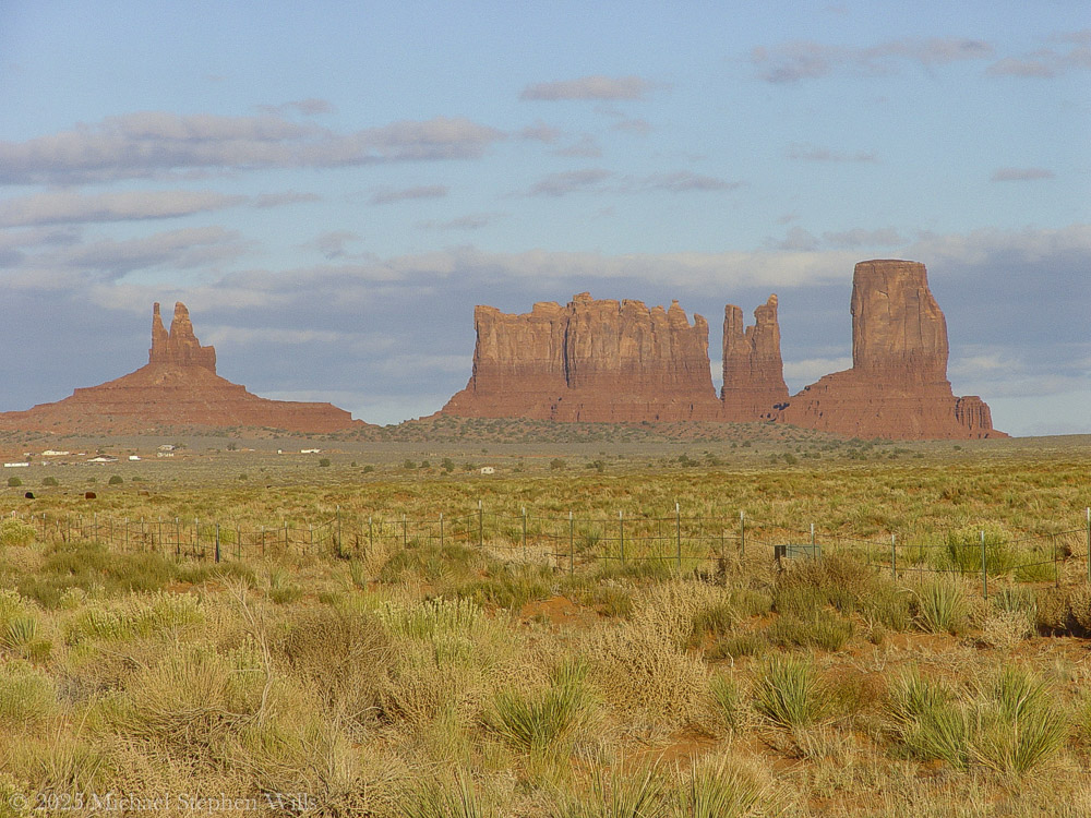
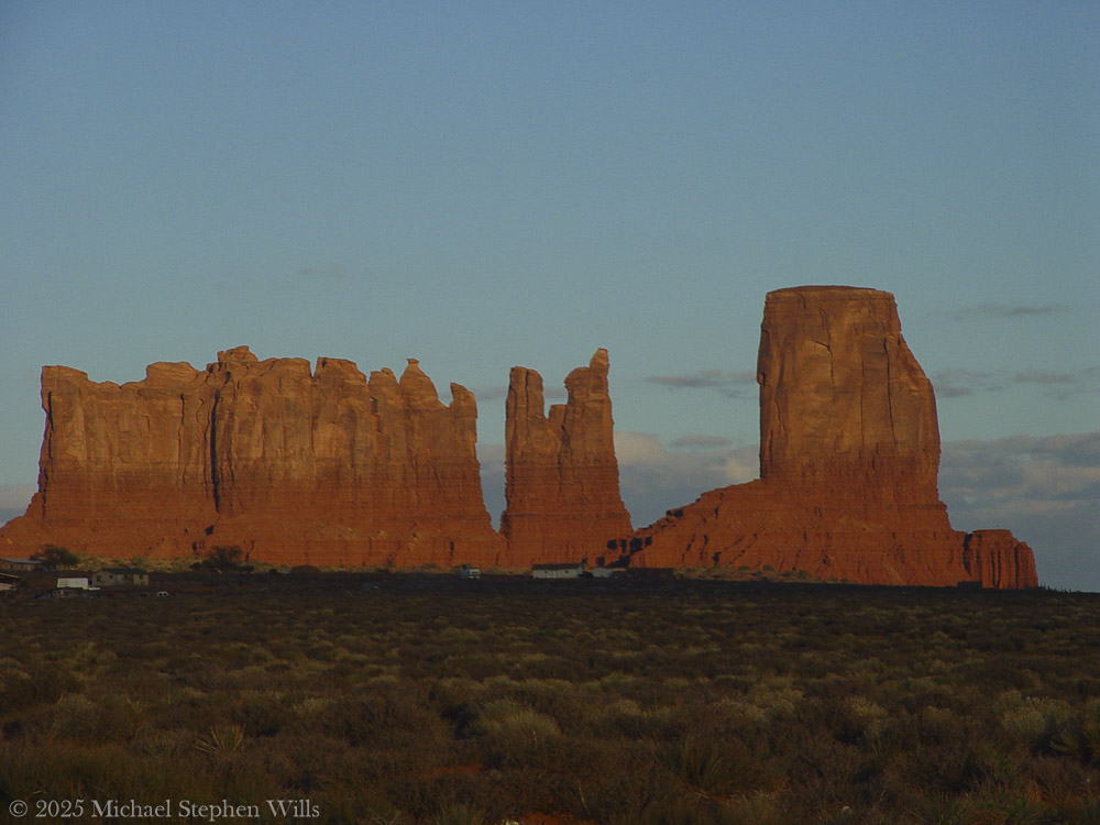
Sentinel Mesa and a slice of Big Indian peak to the left. A risen moon above all.As the day progressed here is Big Indian to the left, a portion of Sentinel Mesa with the risen moon above all
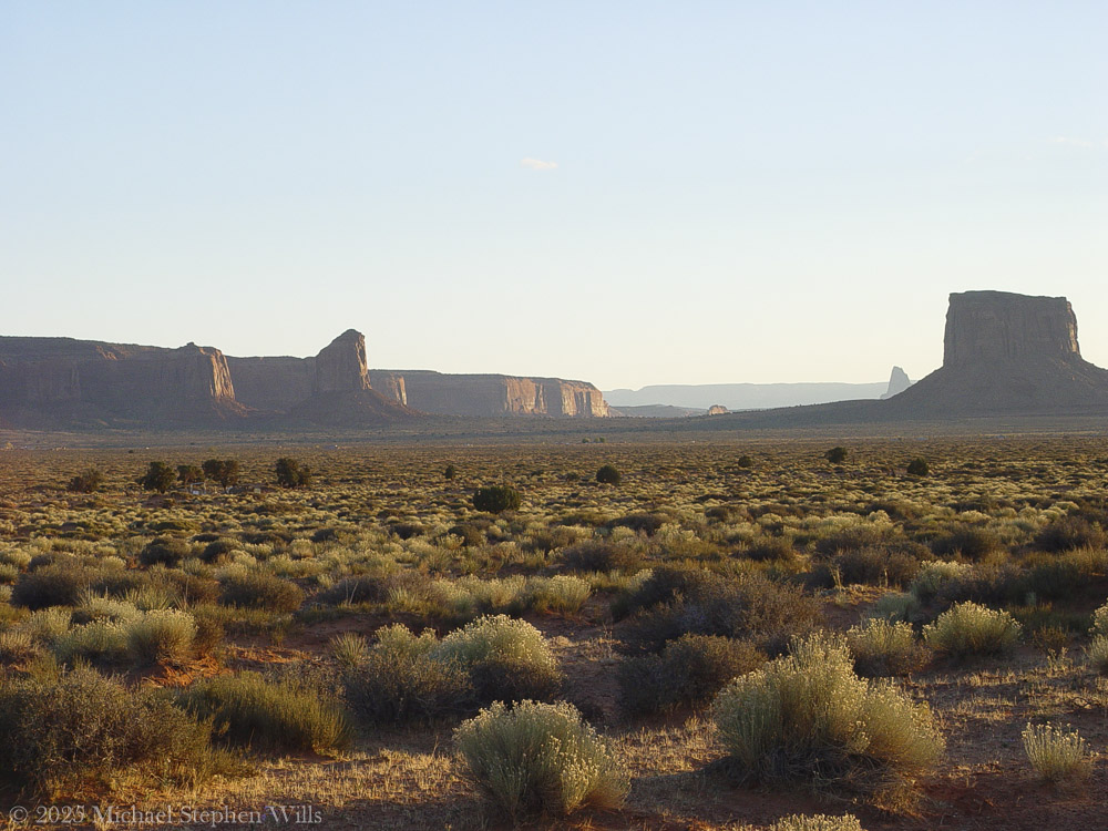
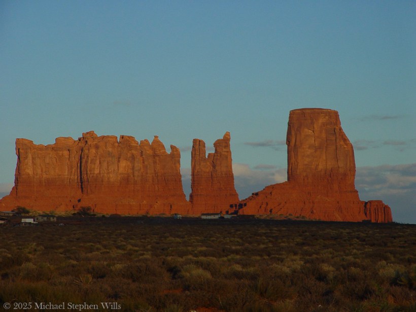
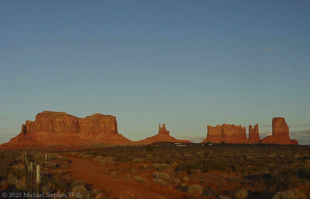
To the east, Sentinel Mesa rose broad and dark, its flat summit catching the last aureate light. The mesa loomed like a great natural battlement guarding the valley’s entrance. Aside, a solitary pinnacle known as the Big Indian stood in muted vermilion hues. In profile it did resemble a weathered face—a monumental visage gazing eternally south over the sacred lands. Farther south, Mitchell Butte jutted upward, its sheer walls burnished red-gold on one side where the sunlight still lingered. A mile or so southeast, the land climbed again to the massive bulk of Mitchell Mesa, now mostly in shadow. The sun was dropping behind it, outlining that mesa’s far rim in a halo of pale fire. Near to Mitchell Butte, a tall slender Gray Whiskers Butte rose like a lonely watchman. Its pinnacle was streaked with dusk, the stone fading from blood-red at its base to a somber gray at its crown. One of the men pointed toward it silently, and the other simply watched, understanding the unspoken thought: how small they were below these giants of rock.
Mitchell Butte, Grey Wiskers Butte and Mitchell Butte
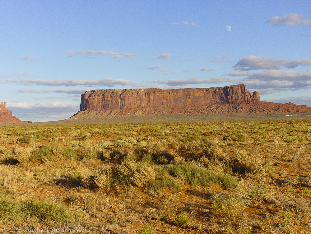
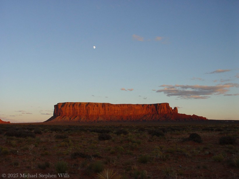
High above Sentinel Mesa, the evening swan of this desert had already appeared — a waxing moon, nearly full and ghostly white. It floated just over the mesa’s dark crown as twilight gathered, like an omen or a blessing. The sky behind the landforms had begun to take on the deep indigo of coming night. In the east, opposite the dying sun, the heavens were lavender and faintly banded with pink. The moon climbed in silence, gaining strength as the sun bled out in a final flare of vermilion along the horizon. In that half-light the mesas and buttes became blackened shapes, cut from the twilight itself, their identities merging with the land’s dusk. November’s chill crept in with the dark. The younger man drew his jacket closed. Neither of them had thought to speak for minutes now. They simply wandered a few yards from the truck, eyes turned outward and upward, silhouettes of their own against the dimming day.
Sentinel Mesa with risen moon
His companion nodded. He opened the door and stepped out. “Never seen anything like it,” the younger man said. His voice was reverent, almost a whisper. The driver climbed out too, boots crunching on red grit. They walked a few paces from the road, drawn forward as if on a tide. The evening air was cool and carried a dry, dusty scent tinged with sage. In the far distance, the monuments cast long blue shadows over the valley floor. The travelers stood for a long moment without speaking, each alone with the scale of it.
The land was vast and inscrutable. In the silence it felt holy. It was easy to believe no one else in the world existed at this hour — only these two and the ancient valley spread before them. The wind came from the west in a long sigh, carrying the dust of the desert. It whispered through dry bunches of brush at their feet and stirred a lonely tumbleweed across the cracked earth. The younger man removed his hat and ran a hand through his hair as if to assure himself this was real. The older man stood with thumbs hooked in his belt, head tilted back to drink in the view. His face was lined and still, the dying light painting one side in gentle umber. If either man harbored any burdens or regrets from the road behind, the land seemed to dwarf those worries into nothing. They felt themselves small as insects on an endless painted floor.
After a time, the driver cleared his throat. “We’ll lose the light soon,” he said. His voice was low. He seemed unwilling to break the spell with anything louder.
The younger man nodded again but did not take his eyes off the valley. “Just a few more minutes,” he replied.
“All right.” The driver smiled thinly and pulled out a cigarette. He struck a match and cupped it against the breeze, the brief flame reflecting in his narrowing eyes. In the glow of the match the canyons of his face showed for an instant, then vanished into shadow again. He drew in and exhaled a plume of smoke that the wind instantly seized and unraveled. Sentinel Mesa crouched out there like a great shadow, crowned now by a silver moon that grew brighter by the minute. The older man followed that mesa’s outline with his eyes, tracing the crenellated cliffs and the slope of rubble at its base. “They named that one right,” he said, mostly to himself.
“What’s that?” the other asked softly.
“Sentinel. Standing guard.” The driver gestured with the glowing tip of his cigarette. “Feels like it’s been watching this place forever.”
Sentinel Mesa standing guard with the red desert floor and fauna in the last light of sunset
The young man considered the hulking form of the mesa. In the twilight it did have the aspect of a watchtower keeping vigil over the valley. “It probably has,” he said. “Long before we ever came.”
On the road behind them a faint glint of chrome from the hood caught a stray moonbeam.
The younger man broke the long quiet. “You ever been down here before?”
The older man nodded. “A time or two.”
“You see all this then?”
A chuckle from the older man, low in his throat. “Not quite like this. First time I come through here I didn’t see a damn thing.”
The younger man looked over, puzzled. “What do you mean?”
“Well,” the old man said, “I’d been driving since Durango, and I’d run out of good sense somewhere near Shiprock. Rolled in with the rain. Thought I’d catch a nap and wake up to a postcard.”
He paused, lighting another cigarette, letting the flame flicker in the cooling breeze.
“Only I parked across from a big ridge in the moonless dead wet dark, didn’t think much of it. Woke up next morning to what I thought was the edge of a landfill. Just a big wall of brown rock. Figured I took a wrong turn and ended up behind a gas station.”
The young man laughed. “You’re kidding.”
“Nope. Got out, stretched, cursed the road and the view and the whole damn state. Got out to take a leak, figured I’d head on. And just as I’m zippering up, I look to the right—and there it is.”
He waved his hand toward the black outline of Mitchell Mesa, vast and solemn in the moonlight.
“The whole valley,” he said. “Caught me sideways. I parked blind to all of it. Missed the whole show.”
He shook his head, the cigarette ember glowing orange.
“Spent the next half hour cussing myself out. Sat there red-faced with a thermos of cold coffee like a man at the symphony who showed up deaf and late.”
The younger man laughed, full-throated now. “You mean to tell me you slept in Monument Valley and thought you were behind a gas station?”
The old man shrugged. “In my defense, it was cloudy.”
They both laughed then, the sound rolling out over the scrub and rocks and into the vastness.
He walked a little farther from the road, and the older man paced beside him. Ground crunching underfoot, fine dust kicking up around their boots. They ascended a slight rise where the terrain leveled off in a broad expanse leading toward the valley proper. Beneath their feet the earth was soft and powdery—red earth, lit now by the dim purple of dusk and the growing lunar light. The younger man scuffed the toe of his boot in it, and a little crimson cloud rose and drifted away. By daylight this soil was a vivid rust-red, the color of dried blood. It was as if the ground itself had a memory of violence or sorrow, but the truth of that color was simpler and older: the iron in the earth, left behind by ancient oceans, oxidizing over eons in the sun and airen.wikipedia.org. The land bled red because the very minerals of its making had rusted in the long passage of time. In places the valley floor was cracked clay, in others loose sand, all part of the same great story of stone turned to dust.
The two men walked out a bit further into the open, where scattered plants clung to life in the hardpan. There were low shrubs of sagebrush exuding a faint herbal scent, and clumps of purple sage with gray-green leaves, their summer blooms long spent. Here and there jutted the spiky forms of yucca, bayonet-tipped leaves fanning out from the base of each plant. Most everything that grew here hugged the ground and wore the dusty colors of the soil. In the failing light, the sage and grass tuft looked almost colorless, pale as ash. Only when lightning storms rolled through would the desert briefly bloom green; in these dry weeks of autumn the vegetation lay dormant, patient. A scraggly juniper tree crouched in a shallow gully nearby, twisted by wind and drought, its bark bleached where it faced the sun. These were the survivors of an unforgiving climate – rabbitbrush, snakeweed, hardy shrubs that lived on almost nothing. The young man knelt and pinched a bit of sage between his fingers, releasing its sharp fragrance. This smell, to him, was the perfume of the desert itself.
In the sand at the base of the sagebrush, he noticed a faint track. He brushed aside some dust to reveal the imprint of tiny claws: the delicate spoor of a lizard that had passed earlier when the ground was warm. It wound off between the rocks and vanished. Other tracks crisscrossed subtly in the dirt – a jackrabbit’s long-toed prints, nearly indistinguishable amid scuffs, and the delicate imprints of some small bird that had hopped about pecking for seeds. Life was here, though it was seldom seen. A red-tailed hawk wheeled silently high above, cutting black circles into the dim sky. Perhaps it was hunting one last time before full dark. The younger man stood again and looked out over the valley with new wonder, realizing that countless creatures lived and moved in this terrain largely unseen. In the daytime heat they sheltered in burrows and shadow. At dusk they came forth. He imagined a coyote trotting through a distant wash on soft paws, nose to the ground; a mule deer picking its way among these rocks somewhere beyond sight; a mountain lion watching from high up on a ledge as it had watched all afternoon. This desert did not easily give up its secrets, but they were there.
The older man stepped out onto a broad flat of rock and ground his cigarette butt under his heel. In the silence his companion could hear the scrape of boot leather on stone. The rock was part of an exposed slab that had broken off from a greater outcrop. It sloped gently down into the valley and was strewn with fine gravel from its own slow decay. The driver pressed his bootsole into a brittle crust of the rock’s surface, and it crumbled with a dry sound. These monoliths around them were not as immutable as they looked. Wind and rain had been gnawing at them for ages uncounted. Every thunderstorm that swept these flats cut new gullies in the shale, undercutting the bases of the cliffs. Every hot summer day the rock expanded, and every cold night it contracted, fissures growing by imperceptible degrees. Water trickled into cracks and ice pried them wider in winter. In time, great slabs would calve off with a roar and a billow of red dust, adding another heap of boulders to the talus at a butte’s feet. The valley was strewn with such piles like fallen ramparts. Erosion was the master sculptor here, patient and inexorable, chewing away the softer rock beneath and leaving the harder stone standing in great towers and tablelands. Each butte, each spire, had endured unthinkable ages to remain in this moment as a seemingly permanent fixture—and yet they too were slowly disappearing grain by grain. In a thousand years the difference might be subtle; in a million, perhaps these forms would be gone entirely, ground down to the flatness of the surrounding plain. The land was alive in geological time, though to human eyes it appeared frozen in a grand and silent repose.
They wandered farther, and now the truck was a small shape behind them on the roadside pullout. Neither man minded. The road was empty; no other vehicle had come along for a while, and only a lone set of headlights glimmered many miles away, moving slowly, probably a rancher or a late tourist heading home. The two travelers were alone with the land and sky. Overhead, the first stars were coming out in earnest, timid specks appearing in the dome of night. The moon was higher now and bright enough to cast shadows. The tall profile of Big Indian was cut into the moonlit sky, unmistakable and solemn, and on the valley floor the leaning spire of Gray Whiskers stood lit on one side by the cold glow. Away to the east, the open desert beyond the valley was falling into darkness, a great stretch of unknown country into which the highway disappeared. And still the west flared with afterlight — a band of deep red on the horizon, fading to gold, then greenish and up into the endless blue-black. It was a sky that seemed too vast for the world.
The younger man found a boulder at the edge of the flat and sat down. He removed his hat and set it beside him. The stone felt cool now under his legs. The heat of the day had fled so quickly that the air itself seemed to crackle with cold. He drew a deep breath and let it out. The land gave back only silence. A great and ageless solitude reigned here, the kind that makes its home in deserts and high places where man has no authority. He could feel it pressing in, not unkindly. It was the solitude of a world largely unchanged long before humans and likely long after. Under that eternal sky and the gaze of those stony sentinels, their own lives felt momentarily trivial. Yet the feeling was not bitterness or despair. Rather, it was humbling and strangely reassuring, as if all the griefs and triumphs that had ever marked a human life were nothing next to the calm presence of these rocks. The earth endured. The earth would always endure. Time and wind would wear down even mountains, but until then these mesas would keep witness over the days and nights, the storms and still mornings, the generations of men who came wandering through seeking something larger than themselves.
The older man walked over and eased himself down on the same boulder. He groaned softly as he sat, rubbing one knee. They both looked out over the emerging night. For a long while, neither spoke. Far in the distance, a coyote yipped — a brief, high sound, then silence again. The younger man smiled in the dark.
“The cold is coming fast,” the older man said after a time.
“Yeah. It does that quick out here.” He picked up his hat and dusted it off, though no dust truly could be kept off in this country. Dust was the true sovereign of the valley — red dust that coated boots and clothes, that hung in the air at midday, that settled on skin like a fine powder. It would ride back with them in their vehicle no matter how well they shook their coats. It had a way of clinging on, a reminder of where one had been.
“You ready?” with a tilt of his head back toward the truck.
The younger man took one last sweeping look over Monument Valley. The forms of Sentinel Mesa and its neighbors were nearly indistinguishable from the dark of the sky now, save where the moonlight etched a line or two along a cliff. The valley floor was lost in shadow. In the east, a few scattered clouds caught a faint silver luminescence from the risen moon. The beauty of the scene was stark and almost aching — a kind of beautiful emptiness that a man carries away inside him, knowing he has witnessed something that can never properly be told. He opened his mouth as if to speak, but no words came. Instead, he simply nodded and got to his feet. They began walking back toward the truck, side by side.
Behind them, the desert night continued its slow unfurling. One by one, stars pierced the darkness. The moon climbed higher on its silent arc. The great stone silhouettes stood unchanged, as they had through countless nights. In a few hours the dawn would come and paint them in rose and gold once more. But for now the valley slumbered under the pale glow of the moon. As the two men reached their vehicle and the engine turned over, its headlights flaring to life, they took one last look across the plains of Monument Valley. Then the truck pulled back onto the highway and receded down the lonesome ribbon of asphalt, two red taillights diminishing and finally vanishing into the boundless Navajo night. The land remained as it was, vast and indifferent to their departure. Sentinel Mesa and Mitchell Mesa stood like opposing pillars at the great gateway of the valley, keeping their eternal watch. The wind sighed over the road and across the sleeping rocks. The footprints the men had left were already beginning to blur with settling dust. Above, the indifferent stars traveled their courses. And the red earth of the desert stretched away in all directions—ancient, patient, and still, beneath the enduring sky.
Enter your email to receive notification of future postings. I will not sell or share your email address.
Copyright 2025 All Rights Reserved Michael Stephen Wills
Here is a journey to Brigham’s Tomb in Monument Valley, reflecting on the land’s timelessness, silent presence, and the profound connection between the observer and natural formations.
He did not come seeking answers, nor was he lost. The road had summoned him—as it had summoned others before him—and he followed its arc with the steadiness of one who does not hurry time. The sun was descending behind him, slow and inevitable, casting long golden blades across the plateau. That was how it wanted to be seen, and he did not interfere.
He had come this way before in dreams, further south where the great stone mittens reached into the sky. There, the land had risen in clarity, each formation distinct in its declaration. But now the evening had deepened, and the land changed its tongue. It spoke more slowly. With greater weight. And he listened.
The air was thin with silence. Even the wind moved differently here—more cautious, more reverent. And then the shapes came into view. Not suddenly, but as if they had always been there and were only now permitting themselves to be noticed.
Here stood Brigham’s Tomb.
On the way to Monument Valley Tribal Park as the sunset for this view on Sullivan Road (Route 163). Navajo County, Arizona. Brigham’s Tomb. On the way to Monument Valley Tribal Park as the sunset for this view on Sullivan Road (Route 163). Navajo County, Arizona. Brighams Tomb is situated six miles (9.7 km) northeast of Oljato–Monument Valley, Utah, on Navajo Nation land. It is an iconic landform of Monument Valley and can be seen from Highway 163. Precipitation runoff from this landform’s slopes drains into the San Juan River drainage basin. Topographic relief is significant as the summit rises 1,000 feet (305 meters) above the surrounding terrain in 0.25 mile (0.4 km). The mountain’s name refers to Brigham Young, the first governor of the Utah Territory. This landform’s toponym was officially adopted/revised in 1988 by the United States Board on Geographic Names after having been officially named “Saddleback” from 1964 through 1987. Some older maps will still show the Saddleback name.
Geology
Brighams Tomb is composed of three principal strata. The bottom layer is slope-forming Organ Rock Shale, the next stratum is cliff-forming De Chelly Sandstone, and the upper layer is Moenkopi Formation capped by Shinarump Conglomerate. The rock ranges in age from Permian at the bottom to Late Triassic at the top. The buttes and mesas of Monument Valley are the result of the Organ Rock Shale being more easily eroded than the overlaying sandstone..
It rose alone, square and solemn, its flanks pressed by the last warmth of the day. The light traced every fracture, every line of sediment like the spine of something ancient and vast. It had no vanity. Its strength was in endurance, in the simplicity of mass. The world had spun uncounted times around this throne of stone, and still it stood—unmoved, unwitnessed except by sky and the slow-growing desert at its feet.
He paused there—not because he was uncertain, but because the monument required it. Some things must be received in silence.
Their topographic relief is significant: Stagecoach rises 900 feet (274 meters) above the surrounding terrain in 0.35 mile (0.56 km), while King-on-his-Throne rises 565 feet (172 meters) in 0.2 mile (0.32 km). Each butte’s toponym has been officially adopted by the United States Board on Geographic Names—Stagecoach is named for its resemblance to a stagecoach, and King-on-his-Throne is said to resemble a monarch surveying his domain. Stagecoach’s first summit ascent was made in 1995 by John Middendorf, Carl Tobin, and Dan Langmade; King-on-his-Throne’s first was in 1967 by Fred Beckey, Marlene Dalluge, Joe Brown, and Don Liska.
To the southeast, past a stretch of ochre earth and sagebrush, rose two more forms. The King on His Throne, upright and proud, shaped as if he had emerged from the stone itself to bear witness. An artifact of erosion, also a sovereign presence—crowned in shadow and wind. There was no question of who he was. His seat was eternal, and no rider passed without first meeting his gaze.
Beside him stood The Stagecoach. Its resemblance to the name was almost too perfect, as if the form had stepped from the myth fully formed. But he knew better. It had not become a stagecoach. The coach had become it. The names were backwards, as names often are. The land had come first. All else was echo.
The giants stood together across the basin, their red-gold skin kindled in the last light. Their arrangement was no accident. One rose alone. Two more aside, bound by rhythm but not repetition. Together they formed a sequence—pause, proclamation, passage.
He walked the trail slowly, camera at his side but silent for a long while. There were things beyond framing. This was not a scene to be taken. It was a truth to be approached.
At the edge of the frame—a photograph not yet taken, but inevitable—the fence stretched taut across the scrub. Old wood. Rusted wire. Man’s line scratched against the land’s permanence. It held nothing. It said nothing. But it was there, and so he acknowledged it, as one acknowledges a child’s drawing pinned beside a mural.
Overhead, the sky was deepening into steel. But the earth still burned, even gently. The buttes and mesas were not dimmed by dusk. They only leaned inward, as if the heat of the day had carried them toward some great remembering.
He had seen many monuments in his life, but these were not monuments in the human sense. These were not built. They were born. They had no need for marble or inscription. Their gospel was in their silence, their liturgy the erosion of time itself.
He stood long, unmoving.
Not lost. Not searching. Just witnessing.
As the light slipped and the forms began to release their edges to shadow, he turned once—not away, but forward. The road still called. And the giants behind him did not diminish. They merely remained, as they always had, and always would.
Waiting.
Enter your email to receive notification of future postings. I will not sell or share your email address.
Copyright 2025 All Rights Reserved Michael Stephen Wills