Another Glenariff View

…with a flowering bush.

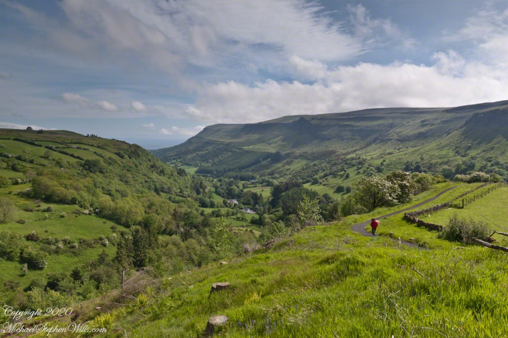
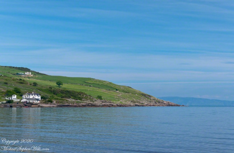
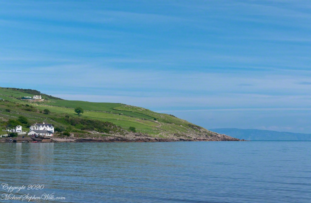
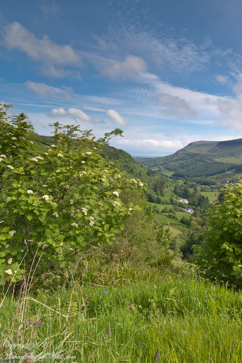
After photographing the broad expands of a wide Glenariff valley, moving the tripod on that same eminence, here is a near and far view.

The foreground white flowering bush of pinnate leaves is Rowan (Sorbus in the family Rosaceae subfamily Maloideae). In Irish it is crann caorthainn, a plant considered sacred in ancient times by both Celts and Vikings. The fruit is made into preserves, jellies. The pinnate leaves are similar to Ash, the reason it is also known as Mountain Ash, Rowan is not botanically related to Ash.

The Canon lens EF 24mm f/1.4L II USM was mounted on the Canon EOS-1Ds Mark III camera. The graduated neutral density filter was perfect for the setting. Notice, between the hills in the distance, is a patch of the Northern Channel (of the Irish Sea), and just visible the Scottish Coast, a tilted horizon uncorrected.

Click photograph for a larger view. To do this from WordPress Reader, you need to first click the title of this post to open a new page.

Here is a link to this photograph on Getty.

Copyright 2020 All Rights Reserved Michael Stephen Wills

Going backward….

….to Glenariff

Here is the first stop on our tour of the Antrim Glens and coast, Glenariff Forest Park. These blogs have gone backward from Torr Head towards the started our day with breakfast in Coleraine, proceeding south along the plain to the head of Glenariff. The name, in Irish Gleann Airimh, means “Glen of arable land.” The Glenariff River flows from the height of Tievebulliagh, a 1,300 foot mountain, to form the broad valley of Glenariff. Arable, means tillable, and the land is tillable because the valley is wide.

This is one of my most popular photographs, it is from that day. I set up the tripod on an eminence overlooking the glen and a park path. Pam, in her red raincoat, headed down. The Canon lens EF 24mm f/1.4L II USM was mounted on the Canon EOS-1Ds Mark III camera. The graduated neutral density filter was perfect for the setting.

Click photograph for a larger view. To do this from WordPress Reader, you need to first click the title of this post to open a new page.

Here is a link to this photograph on Getty.

Copyright 2020 All Rights Reserved Michael Stephen Wills

Cushendun, more information and good bye, for now

…upon the sea-sand….

The National Trust manages the heritage lands on this coast and throughout Great Britain. Looked up Cushendun on their web site and there is some useful information there. If you are touring Great Britain, a National Trust membership is a worthwhile investment. Sadly, there is a notice on the site about Coronavirus restrictions….and closures.

I learned Red Squirrels, an endangered species on the island, have an enclave at Cushendun. We didn’t visit the forested location where they live. We keep up with their antics looking out the window here at home where, thanks to our hemlocks, spruce and walnut trees the species is thriving.

Click photograph for a larger view. To do this from WordPress Reader, you need to first click the title of this post to open a new page.

Here are several more of the information placards near the harbor explaining some local natural and tourism information.

Our travels this day, on the chart, were from Cushendun to Giant’s Causeway.

The last view of Cushendun town as we mounted the steep hill, Torr Road. The dashboard and windshield of out tiny car in the foreground.

Copyright 2020 All Rights Reserved Michael Stephen Wills

Cushendun, a house

…upon the sea-sand….

Here is another information placard found near Cushendun harbor, with a lovely poem.

Click photograph for a larger view. To do this from WordPress Reader, you need to first click the title of this post to open a new page.

Here are several of the information placards near the harbor explaining some local history.

Here is a house on the Cushendun harbor road, windows opening to the Irish Sea. Doesn’t it go well with the poem?

Copyright 2020 All Rights Reserved Michael Stephen Wills

Cushendun Beach View North by Northwest

Nearest Ferry, today

Today, the nearest ferry is just over an hour south, on the M2, Belfast and there is no option for the Mull of Kintyre. You can go to Cairnyan, Scotland; Douglas, Isle of Mann; or Liverpool, England.

Torr Road lopes over the hill, upper right.

Click photograph for a larger view. To do this from WordPress Reader, you need to first click the title of this post to open a new page.

Copyright 2020 All Rights Reserved Michael Stephen Wills

Cushendun Beach View North, ferry destination

Across the Water

North is a glimpse of land across the water, a reason Cushendun was a ferry port since ancient times: the Mull of Kintyre across the North Channel. The ridge to the sea is townland Tornamoney (Irish Tor na monadh).

Click photograph for a larger view. To do this from WordPress Reader, you need to first click the title of this post to open a new page.

Copyright 2020 All Rights Reserved Michael Stephen Wills

Cushendun Beach View South

Tableland

Standing on the beach at Cushendun village, looking south to take in the broad sweep of the shallow bay.

Click photograph for a larger view. To do this from WordPress Reader, you need to first click the title of this post to open a new page.

Copyright 2020 All Rights Reserved Michael Stephen Wills

Cushendun View East

Tableland

Standing on the beach at Cushendun village, looking east towards the Scottish coast, just over the horizon. Cushendun is an ancient ferry port.

Click photograph for a larger view. To do this from WordPress Reader, you need to first click the title of this post to open a new page.

Copyright 2020 All Rights Reserved Michael Stephen Wills

Cushendun View West

Tableland

Standing on the beach at Cushendun village, looking west towards the glens. The Antrim coast is notable for the rising tablelands of broad, eroded valleys, or glens.

Click photograph for a larger view. To do this from WordPress Reader, you need to first click the title of this post to open a new page.

Copyright 2020 All Rights Reserved Michael Stephen Wills

Cushendun View North

Neat and tidy

Here is a view of our route to Torr Head standing on the beach at Cushendun, facing north. The village name in Irish is Cois Abhann Doinne, meaning at the foot of the river Dun, the land here and bay formed by the outflow of rivers from the glens.

Click photograph for a larger view. To do this from WordPress Reader, you need to first click the title of this post to open a new page.

Copyright 2020 All Rights Reserved Michael Stephen Wills