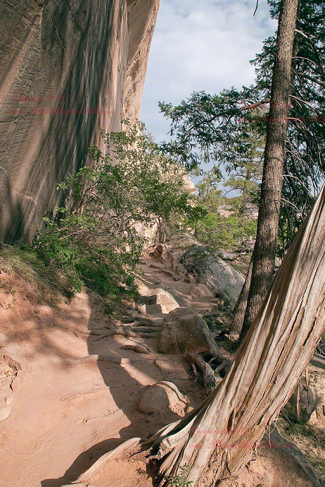
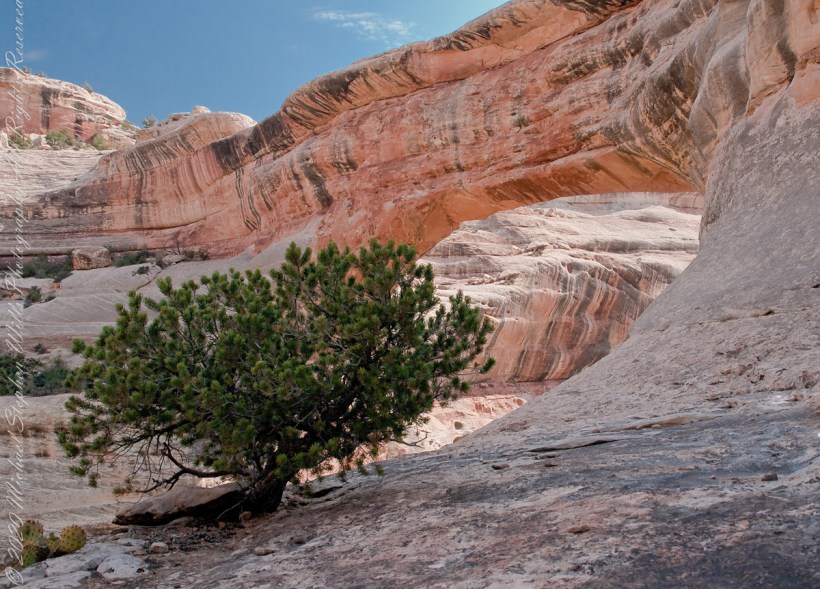
Blog

Around the Kiva

Imagine

Discovery

Imagine yourself as Richard Wetherill in December 1888 rounding up stray cattle on a mesa top, in a snow storm, riding through a very familiar pinyon and juniper forest.  You ride to the mesa edge overlooking a huge canyon and, in the distance and through the snow, see a this “magnificent city.”

Click me for more Mesa Verde works in my Fine Art Gallery

Today

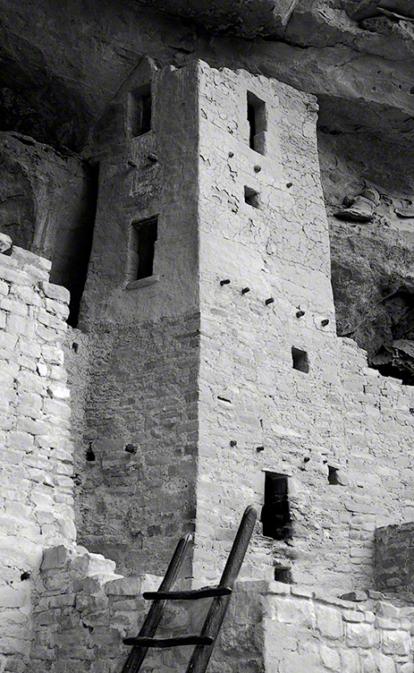
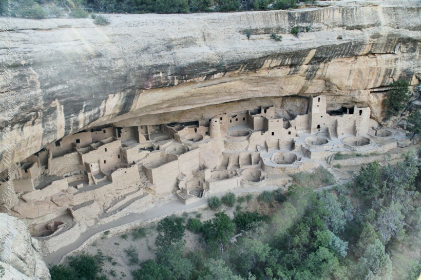
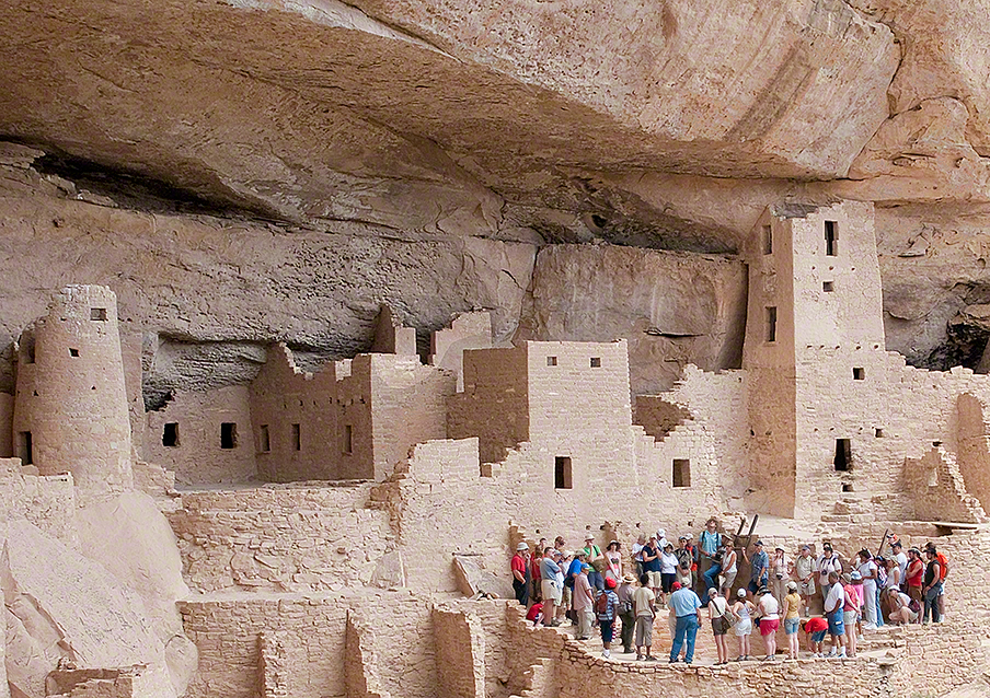
The site is protected and access restricted to these tour groups.  I skipped the lecture, as interesting as it was, to use the time to capture the images in these blogs.  Here is an overview of the northeastern Cliff Palace, including the square (see previous blog) and round towers with the tour group gathered around one of the Cliff Palace kivas.
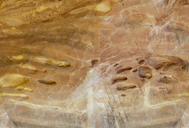
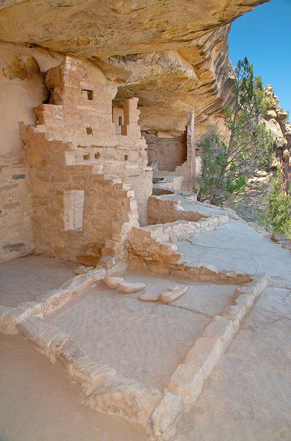
Sipapu

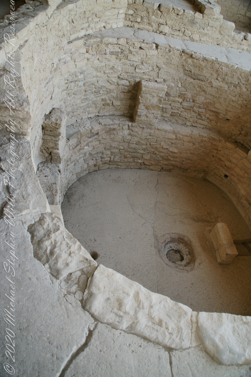
Here is a close-up of the kiva floor of the Balcony House.  Sipapu is a Hopi word for the small hole or indentation in the floor of kivas used by the Ancient Pueblo Peoples and modern-day Puebloans. It symbolizes the portal through which their ancient ancestors first emerged to enter the present world.

The sipapu is the smaller pit in the floor to the left (north side) and partially blocked by the kiva wall. The larger is a firepit. The small wall to the right is placed to deflect airflow from a floor vent.

Click Me for more background on the discovery and excavation of the Cliff Palace

Copyright 2023 Michael Stephen Wills All Rights Reserved

Square Tower as viewed from the Kiva

Cliff Palace Access

Pam and I arrived at Mesa Verde early one summer morning in July and spent time understanding the landscape of the ruin sites and the lighting.  I made a mental visit plan and decided to arrive at the cliff palace mid-afternoon and it turned out, of the tour times available, this was the best.  It is possible to make special arrangements for access, to take photographs, and maybe I will give this a try in my next life.

Click me for more Mesa Verde works in my Fine Art Gallery

Four Stories

This four-story square tower, located at the south end of the alcove, at one time reached the ceiling. Access to the upper rooms was provided by hatchways in the lower room roofs.

What about that T-shaped door?

On the fourth floor, a T-shaped doorway suggests a balcony because that type of opening in the wall, designed to minimize the area, was used as a doorway.

Bend over Backwards

Inside the tower are well preserved wall paintings.  To view them, you side in that lower opening, facing outwards and, bending backwards, look up into the tower.  You need to hold onto the wall to do this and its the only time we were allowed to touch the ruin.

The Kiva

The modern wooden ladder rises from a kiva platform.  Notice the level of wear on the top of the ladder posts.  There are three kivas visible from the tower and at a later time I might post about these.

Copyright 2023 Michael Stephen Wills All Rights Reserved

Summer Views from Chapin Mesa

North-Northeast to the San Juan Mountains

Chapin Mesa is the site of the Mesa Verde Anasazi ruins Balcony House and Cliff Palace.  These are the views you see before the descent below the cliff rim to visit Balcony House.

These views from the Chapin Mesa rim are companions to two photographs of Balcony House, taken on the same morning. You are looking northeast across Soda Canyon, to a thunderstorm building above the San Juan mountains in the distance. Route 550 from Durango to Silverton climbs passes into these peaks, on the way to Telluride. Chapin Mesa is part of Mesa Verde National Park.

The following fine art image is a combination of the previous photographs

Click me for more Mesa Verde works in my Fine Art Gallery

Copyright 2023 Michael Stephen Wills, All Rights Reserved

The Ancient Doors to Mesa Verde

Two Ancient Cliff Swellings

The Anasazi (“ancient ones”) constructed 15 rooms on a 10 foot deep cliff alcove and used a toe-trail (literally a series of depressions in the rock used to gain traction) to climb to the mesa top (shown in this photograph) and the canyon.

A toe-trail security feature is the necessity to start using the correct hand/foot combination, otherwise there will be a point from which it is impossible to proceed. There are 15 rooms here: a kiva, on the far left, a multi-story building, on the right, with 4 upper rooms and 10 ground floor spaces. They probably blocked the openings in cold weather to conserve heat.

Click me for more Mesa Verde works in my Fine Art Gallery

The Anasazi had gardens on the mesa top or the canyon, plus they hunted and gathered wild foods. In the gardens, they planted corn, bean, squash and watermelon in the rich soil. They also gathered wild plants and herbs such as bee-weed, ground cherry, milkweed, cattail, wolf berry and sedge grass Cliff dwelling alcoves include a seep spring, a seam in the rock through which a small amount of water flowed. Imagine the difficulty of hauling water every day if there was not a water source in the alcove.

Can you find the unnamed ruin also in this canyon, we call it “Cliff Canyon”? These ruins are outside the national park boundary, inside the Ute Mountain Ute Indian Reservation.

House of Many Windows

The “window” of this cliff dwelling (ruin) was actually a door!! The Anasazi (“ancient ones”) constructed two rooms in this narrow cliff alcove.

The two rooms here are what seems to be a round wall, possibly a kiva ruin, on the left and a single story building, on the right, being the single wall with an opening for access. They probably blocked the opening in cold weather to conserve heat. It is possible this site had a special use and was occupied for a limited period of time each season/year.

Cliff dwelling alcoves include a seep spring, a seam in the rock through which a small amount of water flowed. Imagine the difficulty of hauling water every day if there was not a water source in the alcove. The large juniper to the left attests to a water source, since it grows from a shared crevice.

The protective alcove was deeper in the past. The desert varnish (the dark marking) above the alcove marks a place where water seeps from the cliff and, in cold weather, expands under the overlying rock, causing it to fall. Can you see where the cliff face has fallen above the ruin? The lack of desert varnish shows the rock fall was relatively recent.

Copyright 2023 Michael Stephen Wills All Rights Reserved

Point Lookout at Dawn, Mesa Verde

Dramatic Entrance

This dramatic butte at the entrance to Mesa Verde National Park, golden in the first light of a July morning.  My wife, Pam, and I were on this road in the pre-dawn hours.  Our delight with this surprise view was worth it.

Click me for more Mesa Verde works in my Fine Art Gallery

In this Point Lookout area, near the park’s entrance, the Mancos Shale is about 2,000 ft thick, and this is what this butte is composed of. Mancos Shale is the lowest formation of the park and is a thick sequence of gray to black marine shale containing minor tan siltstone and fine sandstone beds. On steep slopes, such as those near the northern and eastern boundaries of the park, this formation is prone to landslides and debris flows. This is the base of the butte. The lovely golden rock is Point Lookout Sandstone of the Mesaverde Group, a predominantly yellowish-gray or pale-orange, fine- to medium-grained marine sandstone, approximately 300-400 ft thick. The Point Lookout Sandstone forms much of the cap rock in the northern park area.

I reworked the above image into this Fine Art image of Point Lookout.

Reference: http://esp.cr.usgs.gov/info/meve/

Copyright 2023 Michael Stephen Wills All Rights Reserved

Pam Wills at Loughcrew, County Meath, Ireland

Pam and I were lucky enough to plan our tour of Ireland for May and June when the Hawthorne trees are in bloom.  Named sceach gheal in Gaelic, the white clusters of blossoms symbolize hope.  Hawthorns are plentiful throughout the island.  The Irish revere the tree and associate each Hawthorn with the Little People.  There are roads in Ireland that curve around a Hawthorn tree because the local people convinced the engineers to do so, to save the tree.

This specimen, covered with offerings (to the Little People?), is on the trail to Loughcrew.  Even with her knee trouble, Pam made it to the top of the Hag’s Mountain to visit Cairn T of the Loughcrew Passage tombs.

The steep path to Loughcrew passes a hawthorn covered with flowers and may offerings.

Pam loves to capture images and returned from Ireland with a large collection.  Most of the photos of me at work are by Pam.  Here Pam is capturing the summit view of Hag’s Mountain with the Cairn T entrance gate in the background.  Lucky for us, a fellow visitor made the trip to Loughcrew Gardens and picked up the  gate key from the café.  In a later post I will share my work from inside this passage tomb.

Pam makes friends wherever we go.  She started down the mountain before me to take it easy on her knees.  When I caught up, Pam and a young Irish family were deep in conversation.  I took the opportunity to capture Pam with that gorgeous view to the northwest, Irish countryside with Lake of the Branches in the far distance.

Copyright 2023 Michael Stephen Wills All Rights Reserved

Sipapu Bridge Up Close

This post continues my story of Sipapu Bridge.

I created a series of fine art prints from a visit my wife Pam and I made to Natural Bridges National Monument in Utah.  Here are a few of these prints which grace fine homes around the world.  Click any of the photographs to visit the gallery.

We walked a narrow cliff patch climbed a series of weathered pine ladders  to  achieve these views of Sipapu Bridges National Monument.

While the sky is unchanged, below the canyon rim is another world.  The black stripes of the cliffs is desert varnish, a thin deposit of clay, iron and manganese oxides.  The rock supporting the varnish is resistant to wear and protected from direct precipitation (in this case by the overhanging cliff).

Eventually we came to a ledge with a view of Sipapu Bridge.  Pam took the opportunity to capture this amazing experience.

Mike at Sipapu Bridge
SONY DSC

A Utah Juniper (Juniperus osteosperma). Historically, across the west, Native Americans used the wood in building their houses. They ate the berries; smoked the bark; made shoes, clothing, and rope from it.

Sipapu is a Hopi word for the small hole or indentation in the floor of kivas used by the Ancient Pueblo Peoples and modern-day Puebloans. It symbolizes the portal through which their ancient ancestors first emerged to enter the present world. A natural bridge is formed through erosion by water flowing in the stream bed of the canyon. Sipapu Bridge is 268 feet across and, standing in the stream bed, it is 220 feet above your head.

Here is a close up of the white Permian sandstone of the bridge arch.  The entire canyon is carved from this stone and named after it.

SONY DSC

World Portal

Sipapu is one of the largest natural bridges known.

Part of the Natural Bridges National Monument in Utah, a place inaccessible until the “uranium boom” of the 1950’s and the road was only paved in 1976.

We visited on a July day of thunderstorms, which you see building here.  If you look closely at the base of the bridge, you can see the railings my wife and I used to climbed the steep sides of White Canyon.

We hiked a few miles along an unmaintained trail.  On the way we passed ancient cliff dwellings. The area is a maze of canyons throughout which these ruins are scattered.

Sipapu is a Hopi word for the small hole or indentation in the floor of kivas used by the Ancient Pueblo Peoples and modern-day Puebloans. It symbolizes the portal through which their ancient ancestors first emerged to enter the present world.

A natural bridge is formed through erosion by water flowing in the stream bed of the canyon.

Sipapu Bridge is 268 feet across and, standing in the stream bed, it is 220 feet above your head. That is white Permian sandstone, after which White Canyon is named.

Copyright 2023 Michael Stephen Wills All Rights Reserved

Utah Juniper at Sipapu Bridge

Mike Wills at Sipapu Bridge Photo by Pam Wills

UNIQUE

Here is a unique tree in the unworldly environment near Sipapu Bridge, Natural Bridges National Monument.  I am looking from under a huge Cottonwood tree trunk, in the above photography taken by my wife Pam.

THIS TREE

This tree is an older specimen of the Utah Juniper featured with my fine art print of Sipapu Bridge (click any pic in this posting to view).  Also known as Shag Bark juniper for the thin peices that separate from the trunk.  These tress can live to over 600 years and, like this example, are photogenic.

Utah Junipers are found throughout the American Southwest, here growing near Sipapu Bridge of Natural Bridges National Monument, Blanding, Urah

It is a common species through Utah, being found most often at elevations above sagebrush/grass and below pinyon pine (4,000 to 7,500 feet).  As the environment changes with the presence of people and changing climate, this juniper is becoming more common.  Nearly 1/5th the land of Utah is covered by Utah Juniper.

Macro of the leaves and berries of the One Seed Juniper taken near Kachina Point of the Petrified Forest National Park near Holbrook, Arizona

USES!!

Not shown here are the fascinating (for me, anyway) berries (also called “cones” or “berry-cones”).  Each contains seeds, is hard and green, about a quarter inch across.  If you are brave enough to eat it, you find it to have a pleasant, resinous flavor (a taste like the aroma of pine cones).  These seeds are the manner in which the Utah Juniper spreads.  The tree has both male and female parts and can fertilize itself, so it is possible an isolated stand can all spring from a single individual (unlike humans, for example).

Native Americans consume the berries and the wood, being highly decay resistant, is commonly used for fence posts and other applications exposed to the elements.

Juniper berries are eaten by jackrabbits, foxes and coyotes.  Many bird species rely on this abundant fruit for fall and winter food.  Mule deer will each the scaly leaves when other food is scarce, for example when the winter snows are very deep.

Copyright 2023 Michael Stephen Wills All Rights Reserved

Anasazi Cliff House I

This group of buildings was crafted into a cliff face over 1,000 years ago.

Visitors must climb over the cliff and through narrow tunnels, security features created by the builders.

High Security and Adventure

Security barriers include a 32 foot, entrance ladder made from pine trunks and a narrow squeeze through a 12 foot tunnel.

My photograph of Balcony House features ruins to rooms on a plaza. Also shown are edges of two kivas (circular ceremonial chambers) built into the plaza floor. I am standing in a plaza, next to the cliff.

Behind me (not visible) is the narrow security tunnel used by the ancient builds to control access. Today, visitors crawl through the narrow tunnel to exit the site. There are 40 rooms in Balcony House.

Copyright 2023 Michael Stephen Wills All Rights Reserved