Early Spring III

Circinate

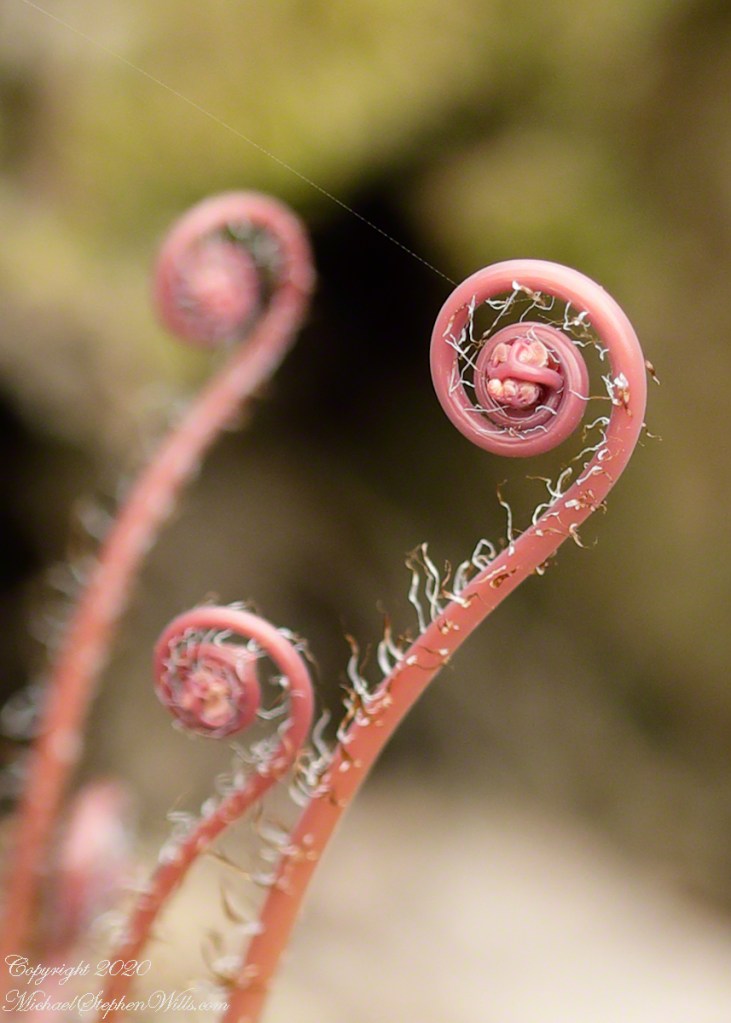
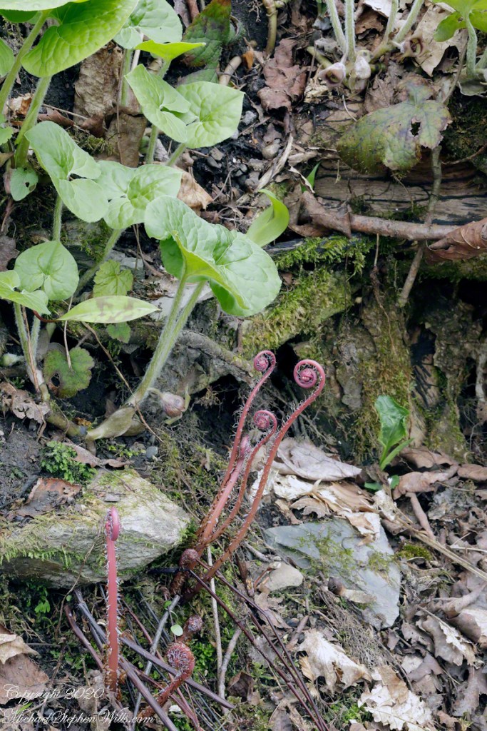
A thumb’s width span for each unfurling stalk of this unidentified colony. Fern? Flowering plant?

Each image is from a Canon 100 mm macro lens, camera mounted on a sturdy studio tripod I carried a few hundred feet to this bank within Fillmore Glen New York State park.

Here is another assignment from the “Fundamentals of Photography” course, to capture a scene at different f-stops, the degree to which the diaphragm is open, to control the width of the lens aperture. Increasing f-stop narrows lens aperture.

For this f32 image, the least possible apeture for this lens, resulting in maximum depth of field. Everything in view is in focus, increasing the visual elements competing for the viewer’s attention. On the other hand, a distracting element is more information about where the plant is thriving.

Click photograph for larger image. To do this from WordPress Reader, you need to first click the title of this post to open a new page.

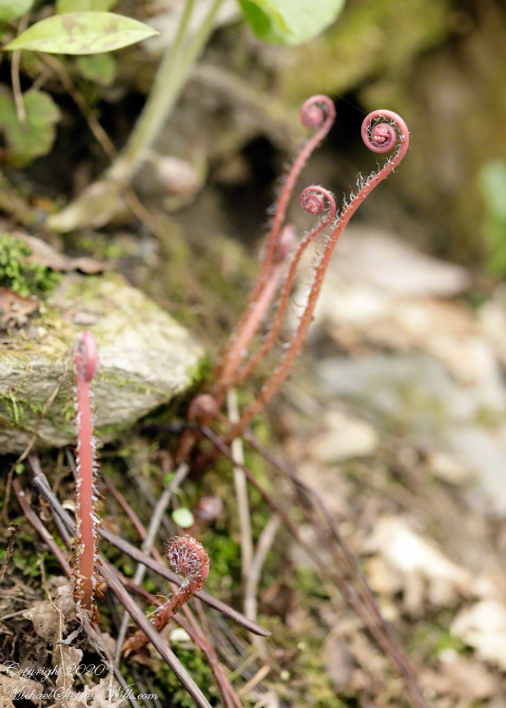
At 8 f-stop aperture is at a midpoint, elements of the background are out of focus, though still recognizable. The sturdy tripod, well situated, enables me to take the exact same view, changing only the f-stop (and associated shutter speed, the higher the f-stop the slower the shutter speed. As the aperture decreases, less light enters the camera and more time is required to collect enough light to expose the digital media. Slower shutter speed means more time for spring breezes to move the delicately balanced plant stalk, resulting a blur for a subject otherwise in focus.

In this image I removed all but the immediate surroundings of the red stalks.

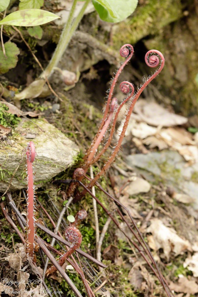
At f2.8 the diaphram is wide open, a maximum amount of light enters the camera and shutter speed is higher as well. Less of the image is in focus, a single subject is in sharp relief. Prior to cropping more than one stalk is in focus, competing for attention.

After cropping a single stalk is the image subject, reminding me of swirling galaxies. The drawback is reduction in image size: 30 reduced to 1.3 (6,744 to 1,371). I needed to reposition the tripod and camera for a closer shot of the circinate scene elements and a image with a higher resolution of this fascinating episode in the life of a plant. I am tempted to visit Malloryville where large ferns unfurl.

Click for my “Finger Lakes Memories” Fine Art Photography Gallery.

Copyright 2020 All Rights Reserved Michael Stephen Wills

Cushendun Published

Photography accepted this week by Getty

Click me to visit Getty, my recently accepted Cushendun photography.

Copyright 2020 All Rights Reserved Michael Stephen Wills

Cushendun Beach View North by Northwest

Nearest Ferry, today

Today, the nearest ferry is just over an hour south, on the M2, Belfast and there is no option for the Mull of Kintyre. You can go to Cairnyan, Scotland; Douglas, Isle of Mann; or Liverpool, England.

Torr Road lopes over the hill, upper right.

Click photograph for a larger view. To do this from WordPress Reader, you need to first click the title of this post to open a new page.

Copyright 2020 All Rights Reserved Michael Stephen Wills

Cushendun Beach View North, ferry destination

Across the Water

North is a glimpse of land across the water, a reason Cushendun was a ferry port since ancient times: the Mull of Kintyre across the North Channel. The ridge to the sea is townland Tornamoney (Irish Tor na monadh).

Click photograph for a larger view. To do this from WordPress Reader, you need to first click the title of this post to open a new page.

Copyright 2020 All Rights Reserved Michael Stephen Wills

Cushendun Beach View South

Tableland

Standing on the beach at Cushendun village, looking south to take in the broad sweep of the shallow bay.

Click photograph for a larger view. To do this from WordPress Reader, you need to first click the title of this post to open a new page.

Copyright 2020 All Rights Reserved Michael Stephen Wills

Cushendun View East

Tableland

Standing on the beach at Cushendun village, looking east towards the Scottish coast, just over the horizon. Cushendun is an ancient ferry port.

Click photograph for a larger view. To do this from WordPress Reader, you need to first click the title of this post to open a new page.

Copyright 2020 All Rights Reserved Michael Stephen Wills

Cushendun View West

Tableland

Standing on the beach at Cushendun village, looking west towards the glens. The Antrim coast is notable for the rising tablelands of broad, eroded valleys, or glens.

Click photograph for a larger view. To do this from WordPress Reader, you need to first click the title of this post to open a new page.

Copyright 2020 All Rights Reserved Michael Stephen Wills

Cushendun View North

Neat and tidy

Here is a view of our route to Torr Head standing on the beach at Cushendun, facing north. The village name in Irish is Cois Abhann Doinne, meaning at the foot of the river Dun, the land here and bay formed by the outflow of rivers from the glens.

Click photograph for a larger view. To do this from WordPress Reader, you need to first click the title of this post to open a new page.

Copyright 2020 All Rights Reserved Michael Stephen Wills

Climb to Torcorr Townland II and beyond

Gorse in flower

In 3.1 miles Torr Road passes nine townlands between Cushendun and Torcorr Townland, each with a namestone holding the Irish and Anglicized name. We can walk it in an hour at a steady pace, the terrane is sliced up so.

Click photograph for a larger view. To do this from WordPress Reader, you need to first click the title of this post to open a new page.

Tornamoney townland is “Cattle Field of the Bogland.” That is the car door, foreground.

Common to all was the slope down to the North Channel.

Rowan Tree directional growth from a constant east wind..

Sheep pasture above the Loughan Cottage ruins.

Here is the friendly owner who climbed off his tractor for a chat with Pam while I photographed.

Here is a slideshow of this post’s images. To visit from WordPress Reader, you need to first click the title of this post to open a new page.
Copyright 2020 All Rights Reserved Michael Stephen Wills

Climb to Torcorr Townland I

Rising from Cushendun Village

Torr Road passes nine townlands between Cushendun and Torcorr Townlands, each with a namestone holding the Irish and Anglicized name. Here are a few interesting names.

Click photograph for a larger view. To do this from WordPress Reader, you need to first click the title of this post to open a new page.

“Ballindam” is derived from the Irish “Baile an tdam”, the Anglicization is the sounding out of Irish. Baile is “town” and “an tdam” is on the dam.

Headed uphill, the next is “Ballycleagh”. Bally is the English pronunciation of Baile. I found “cleagh” on Google translate under “Scots Irish” for “Well.” So, this is the town of the well.

Here is a sheep lookout at the aptly named, Alt gabhair townland, Irish for “Goat Section.” Otherwise known as Altagore.

Here is a slideshow of this post’s images. To visit from WordPress Reader, you need to first click the title of this post to open a new page.
Copyright 2020 All Rights Reserved Michael Stephen Wills