Sun and Shade, Canyon Del Muerto

watch out for quicksand

In my post Canyon of Music, Wind, Light I shared a different photograph of this beetle crawling on sandstone, naming it as a “dung beetle”. I had assumed it was one from once having seen a beetle in an Arizona desert pushing a ball of dung around. This morning, to confirm my assumption, I searched for images of “Arizona Dung Beetle” and was dismayed to find this beetle shares no characteristics with the photographs. Absent smoking gun evidence, sadly lacking in this photograph, I have to admit my “dung beetle” attribution is in error.

Supporting the beetle, the luminous surface of the red sandstone named “de Chelly,” sunlight reflects from durable remnants of the ancestral Rocky Mountains wore to these bits of rock, piled to mountainous dunes by the winds of tens of thousands years, polished to smoothness each against the others.

Natural Markings
Mysterious abrasion and grooves in a de Chelly sandstone cliff, Canyon de Chelly.

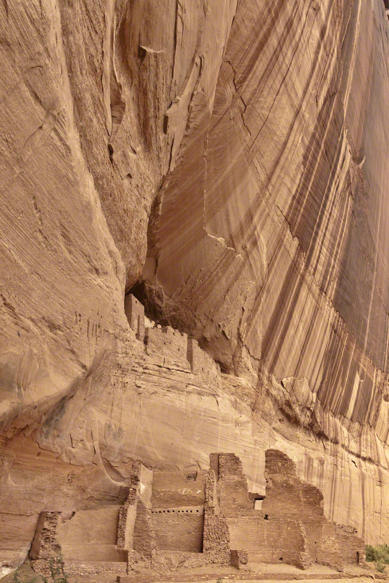
The above photograph is a detail from the brightly lit cliff of the following photograph. The desert varnish and underlying rock was weathered over thousands of years, the sand grains falling to the canyon floor.

Click to view my Arizona fine art gallery
Breadth, Light, Shadow
Canyon Del Muerto vista from a ledge.

The soil of the canyon is composed of these bits of the ancestral Rocky Mountains. What appears to be a white road in the above photograph is not man-made, it is the dried bed of a stream. When a waterway is dry like this, only flowing with rains, it is called a wash. When water fills the wash of the Canyon Del Muerto, the polished sand granules become a dangerous morass, sucking down horses, people, anything unlucky enough to step into it. Every movement, struggling for freedom, pulls the victim deeper down until the wet sand closes over the head and suffocation and death ensues.

Sandstone Stairs
Stairs cut into the sandstone cliff of Canyon de Chelly

The waters Canyon De Chelly National Monument naturally form a vast Y into the Defiance Plateau, naturally because two major streams merge into one canyon a few miles above Chinle. On both our guided trips, heading east from Chinle there is a branch. On the right De Chelly canyon continues. On the left is Canyon Del Muerto. The photos in this post are all from “The Canyon of the Dead”, what the name means translated into English.

Click to view my Arizona fine art gallery

No, it is not named this because of the quicksand. Conditions for quicksand are present throughout canyons of the southwest. It is history of human occupation for which this canyon was named. I will cover it in a future posting. For now, I will say the above views are from the spot featured in “Family Trek.”

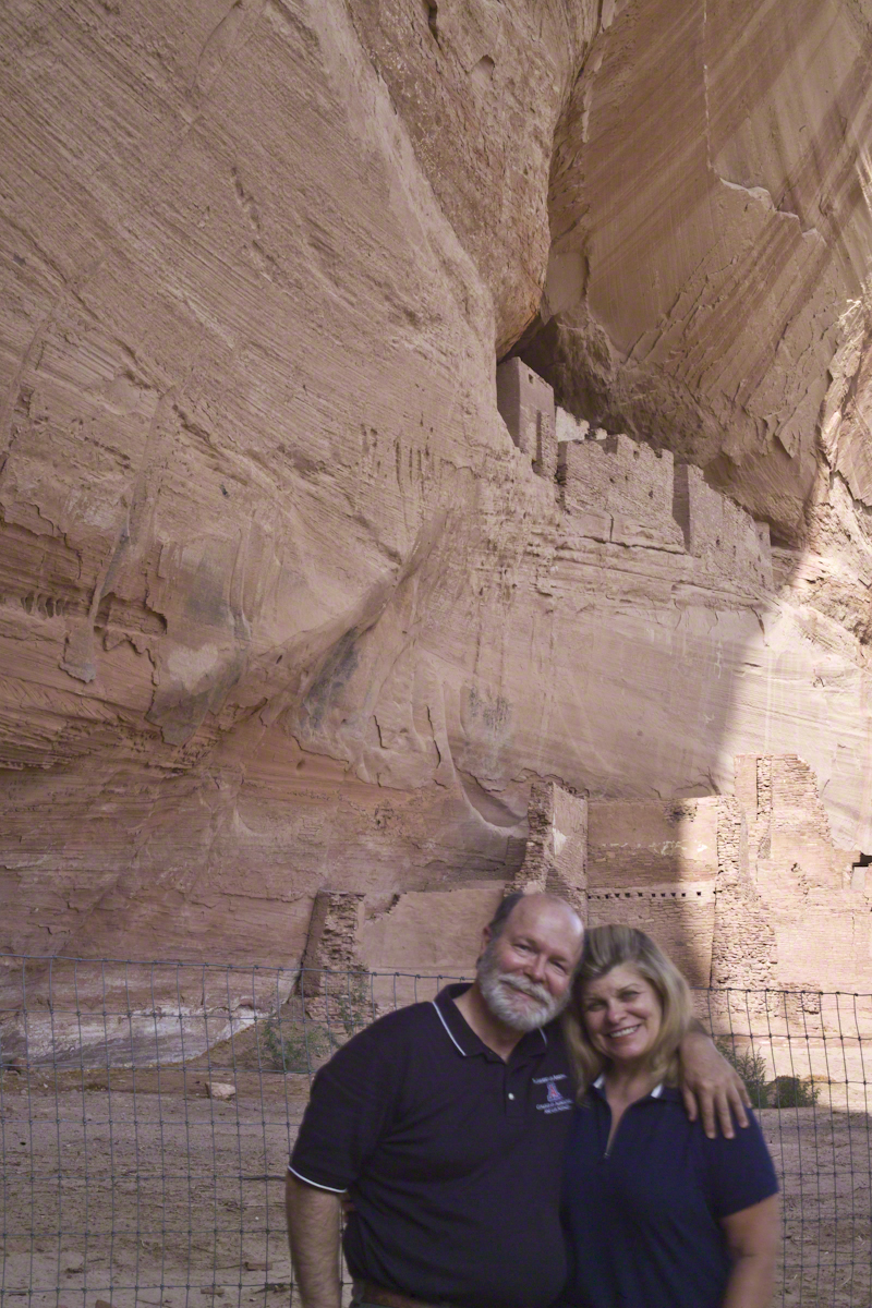
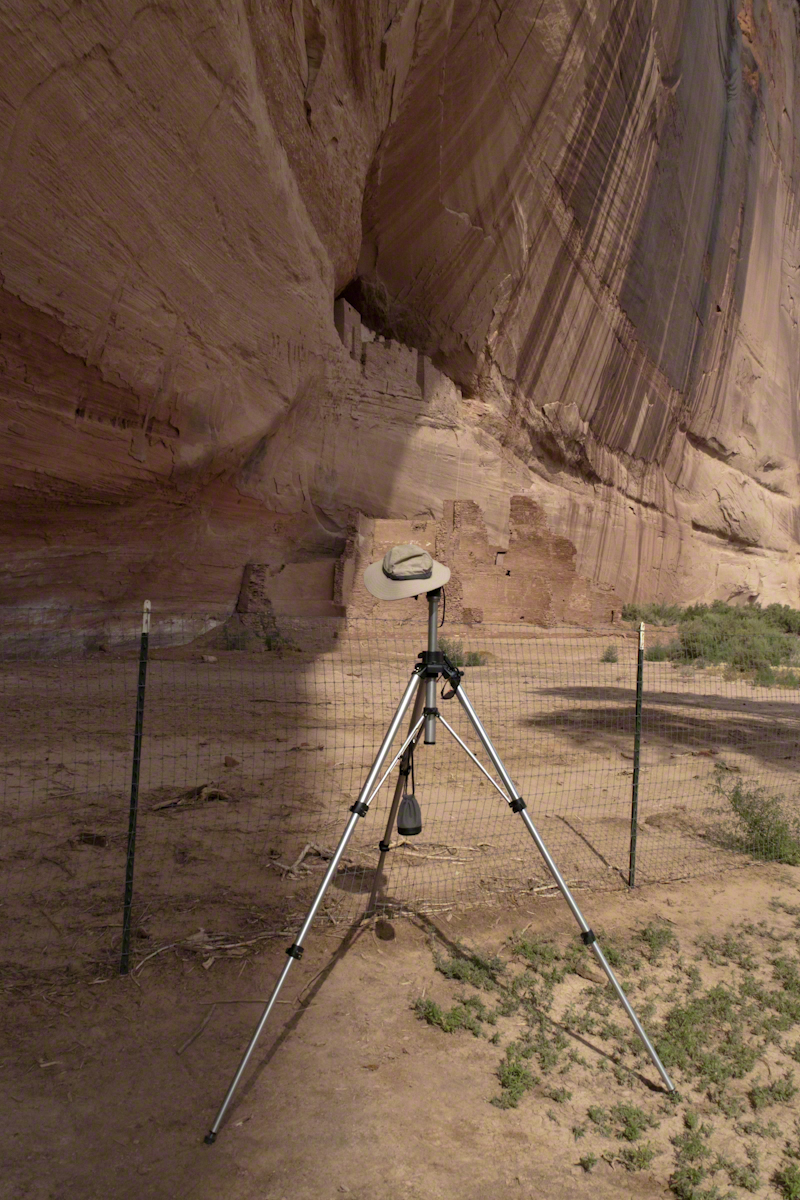
My first visit, in 2003, while my son Sean climbed the rocks with our guide, I was left to document the wondrous surroundings. The above shallow cave is reached by that stairway carved into the precipitous ledge. The access to the cave is via those naturally occurring ridges of the cross bedded sandstone. It is another example of De Chelly sandstone formed from the windblown edge of a monstrous ancient sand dune.

Monumental Cliff
A solid block of De Chelly sandstone formed from the central bulk of a sand dune.

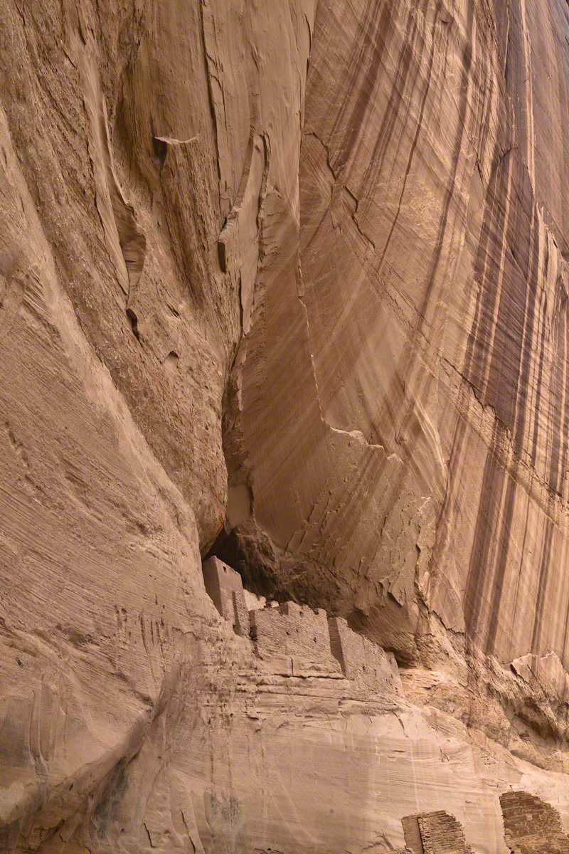
Here is another example of rock formed from the solid body of the sand dune, that unbroken and un-striated cliff. Below is the cross-bedded, windblown sand.

Cliff with Foliage
Autumn lights up the floor of Canyon De Chelly, the foliage rivals the cliffs for wonder at this time.

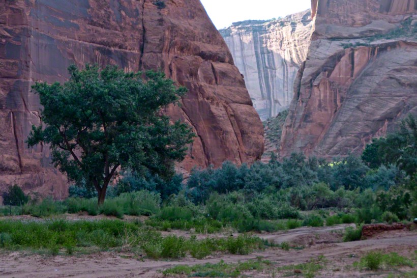
As we proceeded generally east from the climbing spot of “Family Trek”, driving by the golden cottonwood foliage I asked the guide to stop for these photographs.

Canyon de Chelly
Canyon walls

Soon the cliffs hid the sun.

Canyon de Chelly

Notice the modern water distribution system (pipe) at the foot of cliff on right. These vast tracks of shadow adjacent to bright sunlight are a fact of life for canyon dwellers, a source of joy and wonder.

Canyon de Chelly

The canyon here is rather like the Narrows of Zion, without the water.

Canyon de Chelly

Enjoy!!

Click for the another Arizona post, “Juniper Sunrise.”

Click for the first posting of this series, “Portrait of a Navajo Guide.”
 
Copyright 2021 Michael Stephen Wills Photography

Pinelands Connections VIII

Ancestral Byways

……click for “Pinelands Connections I”.

These photographs were taken the last days of August 2021, the 26th and 27th, while exploring Burlington County, New Jersey, with my sister. I will be writing about our Thursday and Friday for awhile, starting with today’s installment.

Quaker Bridge Road traverses the wilderness of Wharton State Forest with a beginning off Route 206, Atsion Mansion. Our planning included Jeep Wrangler rental, only high-clearance 4-wheel vehicles are appropriate, the road surface is humpy sand, water filled holes abound. Still, sitting there at the start, with Atsion Mansion house in view, I waited awhile until a high clearance tour bus packed with adventurers, kayaks passed into the pines and out of sight. We proceeded an uneventful ~4 miles to Quaker Bridge at a stately 5 miles per hour, invoking four-wheel drive low gear a mile or so in.

Here is Quaker Bridge over Mullica River today, facing East.

Quaker Bridge road was a well traveled main route through the Pines for almost a hundred years with an inconvenient crossing of The Mullica at this point. During the year 1774, some sa 1772, West Jersey Quakers travelling to the Little Egg Harbor Yearly Meeting, started “a day early”, built a bridge. From a c.1940 photograph it is clear in that “day” they felled large trees for pilings, smaller trees, pines and cedars, for the other bridge elements. Since then, the crossing has been called “Quaker Bridge.”

Over time, the east side became a resting place, with at least one Inn/Tavern. Here is the east side today.

Even without hospitality and bustling humanity, after 4 miles of dreary road from Atsion this spot carries a sense of lightness, the well spaced straight pines over several acres conveying peace and rest. Over 35 miles from the ocean, the white sand presents as beach. There is a reason for this feeling, a 15 million year reason.

Between 15 and 10 million years ago the earth climate turned colder, so much water evaporated from the oceans to fall as snow and ice in the polar regions ocean levels fell 150 to 250 feet. As the ocean fell away, over eaons, mountains to the west were ground down, pulverized by the elements to flow, gather on the exposed plain. The white “beach” sand we see today, at Quaker Bridge and other Pinelands places, are surfaces of this “Cohansey” sands and clay ranging in thickness from 25 feet in the west to more than 300 feet at the Atlantic Ocean.

Over millions of years the land raised to become the drainage patterns we see today. The renewable resources of “bog iron” and water spring from this history.

Standing there I imagined Great Great Grandmother Ann (Milley) McCambridge resting on the journey from the McCambridge home near Speedwell. I placed the pebble, collected from Long Island Sound, on Grandmother Ann’s headstone the evening of August 26th. Click this link for more about Ann McCambridge.

Click for the next chapter, “Pinelands Connections IX”

Reference
I found Quaker Bridge background in “Heart of the Pines, ghostly voices of the Pine Barrens” by John E. Pearce, pp 748 – 750, Batsto Citizens Committee, 4110 Nesco Road, Hammonton, N.J. 08037-3814.

“The Geologic History of New Jersey’s Landscape”, Scott Stanford, Unearthing New Jersey Newsletter, Vol. 1, No. 2, Summer 2005, New Jersey Geological Survey, Department of Environmental Protection e, Scott Stanford

“Hydrostratigraphy of the Kirkwood and Cohansey Formations of Miocene Age in Atlantic County and Vicinity, New Jersey,” Peter J. Sugarman, 2001, New Jersey Geological Survey Report GSR 40, New Jersey Department of Environmental Protection

“Background information on the Cohansey Formation aquifer.”

Copyright 2021 Michael Stephen Wills All Rights Reserved

White House Ruin

iconic image

November 2003 my son, Sean, and I drove up route 191 from the Petrified Forest National Part to arrived at Chinle on a November afternoon. In 2003 my photography kit included a Sony Point and Shoot 5 MP camera with filters, an over the shoulder (purse type) bag and an inexpensive “Kmart” tripod.

We found the White House trailhead, hiked down essentially alone as the sun set at 5:20 pm.  At that time, a thick stand of Russian Olive trees choked the wash.  We stopped at this point in the gathering dark.  I took this distant shot of the White House Ruin against the Russian Olive autumn foliage.  A stand of Cottonwoods growing near the canyon wall had yet to turn their brilliant yellow.  At that time, the White House Ruin was painted white.

WhiteHouseRuin20080718-3

When Pam and I visited July 2008, in the intervening 4 years, 9 months the Russian Olives were removed as an invasive species, the ruin was no longer white.

There is one highway headed south in the Four Corners region of Northern Arizona, the same route 191 Sean and I took.  In 2008 Pam and I came from Colorado south on 191, also arriving late afternoon.

That July day the sun set 8:33 pm as the Navajo Reservation observes daylight savings time. My goal was to photograph the White House Ruin I missed in 2003. We arrived at the trail head. My photography kit was expanded from 2003, now included a Kodak DSC Pro slr/C, the “C” meaning “Canon” lens mounting, a Sony 700 alpha slr (I only use a variable lens), Manfrotto tripod with hydrostatic ball head, and the backpack style Lowe camera case. With the tripod it is over 25 pounds.

With this on my back I was prepared to boogie down the trail. At the height of tourist season there were many more people at the trailhead. Pam, being a friendly person, started a conversation while I ploughed ahead along the flat canyon rim. It is solid red sandstone, beautiful, generally level with enough unevenness to require attention. When Pam saw how far ahead I was she tried to catch up, tripped, fell hard.

I backtracked to Pam and we pulled it together. She thought, maybe, the fall broke a rib. We descended, slowly, together. Here we are in front of the ruin. The sun, low in the sky, is moving below the south canyon wall. This is a perfect time and I used both cameras.

Mike and Pam at White House Ruin
Mike and Pam Wills with the White House Ruin, Canyon de Chelly, July 2008

The sweep of cliff and desert varnish was my intent to capture. Here it is through the Canon 50 mm lens.

WhiteHouseRuin200807-8
Click link for this White House photograph in my Online gallery.

I captured this version with the Sony Alpha 700 slr, the variable lens set to widest angle.

White House Ruin
Click link for this White House photograph from my online gallery.

Here the camera setup waits out the sun…..

Whte House Ruin Setup
Camera, protected by hat, mounted on Manfrotto Tripod at the White House Ruin, Canyon de Chelly. July 2008
Click for the first posting of this series, “Portrait of a Navajo Guide”.

Click for the next posting of this series, “Family Trek.”

Copyright 2021 Michael Stephen Wills Photography

Drombeg Stone Circle VIII

Seventeen Stones

The photograph shared the last Drombeg posting needed hours of reworking before it was ready for submission to Stock Photography services. Ireland photography is my “money maker”, so the effort is work this.

Today, I share the image as it existed in camera, to the final product. The most detailed work was removing the human figures in the upper right corner. The camera sensor was problematic, with an light accumulation of dust. Below are the two images, each alone and as slideshow for flipping back and forth.

What differences can you observe? (comments, please)

Click any pic for a larger view, in a new tab, or a slide show. When using WordPress Reader, you need to open the post first.

llllll

Click Me for the next post in this series

Copyright 2021 Michael Stephen Wills All Rights Reserved

Summer Garden

2021

Pam requested photographs of hosta flower stalks with blooms and developing buds. I setup the Manfrotto tripod, the Canon dslr mounted with an Canon EF 70-300mm f/4.5-5.6L lens at ISO 1600 and these are the results.

Native to northeastern Asia, In 1812 the genera Hosta was named for the European botanist Nicholas Thomas Host. Also called plantain lily for the habit of the herbaceous stalks to grow radially from a center.

The name “Hydrangea is derived from Greek and means ‘water vessel’ (hydria), in reference to the shape of its seed capsules. The earlier name, Hortensia, is a Latinised version of the French given name Hortense, honoring French astronomer and mathematician Nicole-Reine Hortense Lepaute.” _wikipedia


The common name “Marigold” refers to the Virgin Mary.

Begonias come in so many shapes and colors.

Garden Gnomes, Bird Bath and Sculpture

Copyright 2021 Michael Stephen Wills All Rights Reserved

Climb to Gorge Trail

Potential danger abounds

Capturing photographs and videos on the fly using an Iphone, we visited Fillmore Glen State Park, Moravia, New York with our granddaughter, Nia. This is the third post of this series. Click me for the first post in this series.

Emerging from the blind canyon of Cowsheds Waterfall, we are faced with this gorgeous pool fed by Dry Creek (yes, that is the name). Formed by a dam, the water is deep and very cold.

We were standing on this footbridge for the above photograph. The trail to Cowsheds is on the far side of Dry Creek and to the right.

We have yet to count these steps, don’t know why. The limestone blocks were quarried locally from the same stone of the creek bed. The gorge trail begins at the top.

Trillium Seed Capsule

This is a Purple Trillium, I believe, formal name Trillium erectum. It is a large specimen judging form the width of the bracts, leaf like structures at the based of the flower stalk. When fertilized, the ovaries form this seed capsule containing up to 16 seeds, each with lipid with a high content of oleic acid. During summer, the capsule opens, seeds disperse. Ants encounter the seed elaiosome, the oleic acid content triggers “corpse carrying behavior.” The ants carry the seeds into their nests, consume the lipids leaving the seeds. After a year dormancy the seeds sprout and the additional depth in the ant nest provides a good start.

Trillium are a favorite food of deer, unfortunately. Some seeds are spread this way, passing through the digestive tract and out in fecal waste. I use the color of the seed capsule to identify it was Purple Trillium. In my experience the white variety (Trillium grandiflorum, and others) has a light colored seed capsule.

Copyright 2021 Michael Stephen Wills All Rights Reserved

Drombeg Stone Circle VI

Seventeen Stones

Here is one of my finest photographs from that morning. The ocean view is a reason Drombeg is one of the most popular neolithic sites.

The Celtic Sea is close to this site, unoccupied since 800 BC, may be as old as 1100 BC according to radiocarbon dating from 1957 excavations. Thirteen of the original seventeen stones form a circle 31 feet across. Two portal stones face a recumbent stone, together forming a axis pointing to the sun position at sunrise on the winter solstice. One of the most visited Neolithic sites in Ireland, it required some patience to achieve an image without human figures.

Click any pic for a larger view, in a new tab, or a slide show. When using WordPress Reader, you need to open the post first.

The camera is set on a tripod positioned in front of the recumbent.

Click Me for the next post in this series

Copyright 2021 Michael Stephen Wills All Rights Reserved

Presidents Fillmore and F. D. Roosevelt

A U.S. President born in a log cabin, MiIllard Fillmore

Capturing photographs and videos on the fly, we visited
Fillmore Glen State Park, Moravia, New York with our granddaughter, Nia. This is Pam and my favorite park for the lack of crowds, variety of wildflowers and dramatic views.

A the bottom of Gorge Trail, near the creek fed swimming pool, is a cabin moved to the park from a few miles away to commemorate an American President’s birthplace. Milllard Fillmore was born on the peneplain above the gorge of Dry Creek in a place called Locke, five miles from the modern park entrance. His birth cabin was destroyed in 1852, the land is dedicated to his memory with a monument. This cabin of a type identical was disassembled and reconstructed on this spot in 1965 by the Millard Fillmore Memorial Association.

The 480 square foot (20 by 24 feet) original (the rebuild is a bit smaller) had a central fireplace and and will chinked logs, a ceiling of simple planks.

The cedar shingles were hand made, as were the nails.

More information on a display inside the cabin.
A few feet away is a memorial to Franklin D. Roosevelt’s Civilian Conservation Corps. We can thank them for building much of the park infrastructure we depend upon today.
Copyright 2021 Michael Stephen Wills All Rights Reserved.

Drombeg Stone Circle V

Seventeen Stones

The Celtic Sea is close to this site, unoccupied since 800 BC, may be as old as 1100 BC according to radiocarbon dating from 1957 excavations.

Click any pic for a larger view, in a new tab, or a slide show. When using WordPress Reader, you need to open the post first.

The Celtic Sea is close to this site, unoccupied since 800 BC, may be as old as 1100 BC according to radiocarbon dating from 1957 excavations. Thirteen of the original seventeen stones form a circle 31 feet across. Two portal stones face a recumbent stone, together forming a axis pointing to the sun position at sunrise on the winter solstice. One of the most visited Neolithic sites in Ireland, it required some patience to achieve an image without human figures.

Click Me for the next post in this series.

Copyright 2021 Michael Stephen Wills All Rights Reserved

The Space Station and the Waterfall

Potential danger abounds

Capturing photographs and videos on the fly, we visited
Fillmore Glen State Park, Moravia, New York with our granddaughter, Nia. This is Pam and my favorite park for the lack of crowds, variety of wildflowers and dramatic views.

Growing near Cowsheds Waterfall, at the foot of Gorge Trail, was this
strange fruiting wildflower so like a modular space station. It is Baneberry.  There are white and red forms. This is white Baneberry (Actaea pachypoda).  These terminal round nodes resolve into white balls with black dots, like dolls eyes. The cylindrical connectors (as in space station) turn bright red. Red Baneberry (Actaea rubra) has bright red berries. The flower is a fluffy white mass that gives no hint of the seed form.

All parts of both forms are highly poisonous, the bane of Baneberry. The berries are deadly. Ingestion of as few as two berries by children will cause death from cardiac arrest. Six for an adult.

Click any photograph for a larger view.

Cowsheds Waterfall is littered with enormous limestone blocks, remnants of a shelf. The rock under the limestone, a soft shale, is worn away first by running water forming a room (or Cowshed) under the limestone. Eventually, the limstone falls into the creek. The waterfall is at the end of a blind canyon with a sign at a trail end warning visitors to go no further. Careless visitors to Finger Lakes Gorges are killed, on occasion, by falling rock when they loiter beneath cliffs.

Overview of the site
Click me for my Fine Art Photography Gallery.
Copyright 2021 Michael Stephen Wills All Rights Reserved.