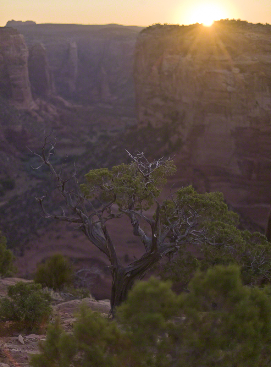
In this post we start the day of my posting “Family Trek“, July 19, 2008, when, well before the sun rose at 6:23 am Mountain Daylight Time (the Navajo Reservation observes daylight savings, the rest of Arizona does not), Pam and I were at the Spider Rock Overlook.
Most visitors to the canyon make use of a system of roads and parking lots next to strategic views. There is the White House Overlook we visited our first day, July 18, to hike from the trailhead into the canyon. There are also, on the south side of the canyon:
Tsegi Overlook, taken from a Navajo word that translates directly to “between the rocks” and usually refers to a deep canyon with steep cliffs.
Junction Overlook above the point where Canyon Del Muerto (see my posting “Sun and Shade, Canyon Del Muerto”, and Canyon De Chelly intersect. There is an Anasazi ruin in the south-facing cliff across the canyon.
Sliding House Overlook, another Anasazi run across the canyon.
Face Rock Overlook, to view the eponymous formation.
Spider Rock Overlook, the most stunning rock formation.
Click any photograph for my Online gallery.
Looking east from the Spider Rock overlook, Canyon De Chelly.
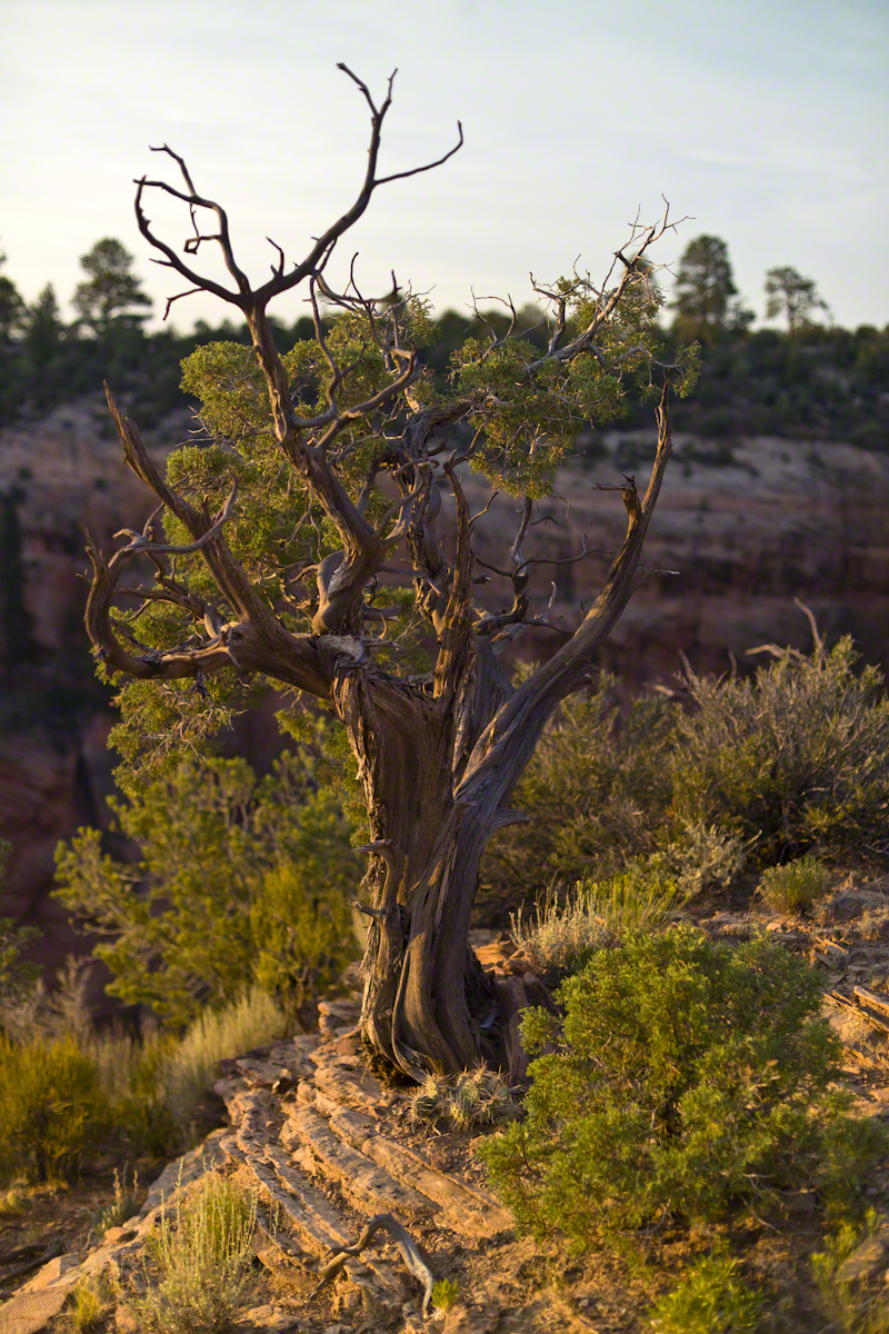
While getting ready I scoped out the location for interesting visual tropes. Utah Junipers are exceptionally hardy shrubs, stressed individual plants grow into compelling forms shaped by hardship. As the sun rose, this specimen emerged from the gloom and caught the first sun rays.
Click any photograph for my Online gallery.
A distressed Utah Juniper on the edge of Canyon De Chelly overlooking Needle Rock a few moments after sunrise.
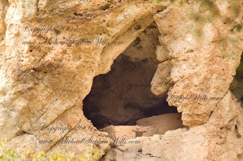
About 700 years ago, when the expansion of the Mongol empire was under way, on the other side of the planet people discovered a series of caves, formed in tuff, with a favorable location in a south facing cliff near water. Tuff, a rock formed from volcanic ash, is hard, brittle and soluble in water. From these properties this series of caves formed. The southern exposure provided excellent climate control for people, like those we now call the Salado, who understood how to exploit the location.
They constructed from local materials (mud, plants and rock) rooms in the upper cave just far enough inside to be warmed by the winter sun and protected during the summer when the sun’s sky-path was higher. Who knows how long the Salado lived in what must have been this paradise or why they left.
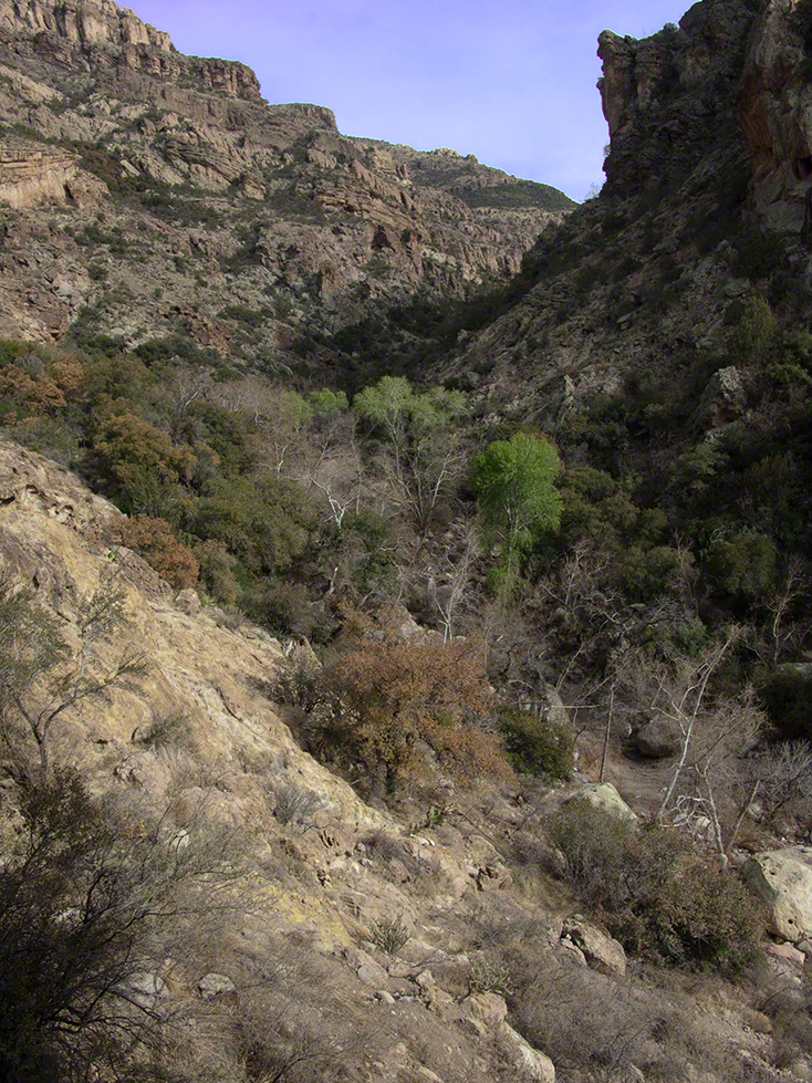
In March 2006, after returning from a nine-day backpack trip to the remote eastern Superstition Wilderness I used a four-wheel vehicle to reach the Roger’s Trough trailhead for a day trip to this site in Roger’s Canyon. The advantage of Roger’s Trough is the high elevation that leaves “just” about 1,100 feet of climbing (2,200 total) for the day. As it happens, it is downhill to the ruins though there is plenty of ups and downs plus scrambling over rocks.
I started late morning and a returning party met me on the way out and warned against leaving packs unattended. It seems they were victimized by pack rats. My timing was lucky and I had the site to myself.
First (refer to the “Roger Canyon” photograph, above) I climbed the cliff opposite from the ruins to set up a tripod an telephoto lens to shoot through the trees to capture the main building inside that very interesting looking tuff (see below). That central column (to the right) divides the cave opening and there are views from inside, up and across the canyon. In season, the cliffs are occupied by nesting birds and, higher up, there are fascinating caves in locations too high and steep to reach without the proper equipment.
As it is, climbing into the upper cave requires an exposed rock scramble. By “exposed” I mean the climber is exposed to falling. That is an intact wooden lintel of the visible structure opening and the larger structure, to the right, has curved walls.
Salado Cave Ruin
I then explored in and around the site. The location of a lower cave made it useful for storage, it was walled off and the sturdy structure still stands today. By the way, I inverted this view for artistic purposes.
Lower Storage Room
A lower cave is opened and accessible. Looking out, I felt the original inhabitants were with me and then a raven started calling over and over and over.
Lower Cave
I was so fascinated by the possibilities of the site that time got away from me until this incessant cawing of a raven made me notice the lengthening cliff shadows. Here is a view (see below) of my way home, back up Rogers Canyon. My last shot before packing up. It took just over two hours to get out, at a steady pace. It was twilight as I approached the Rogers Trough trail head.
By the way, my posting before this one (“Finding Circlestone”) includes a shot of White Mountain. In that view, these ruins are on the other side of White Mountain.
View up Rogers Canyon from the Ruins
Copyright 2023 Michael Stephen Wills All Rights Reserved
The Contreras fire threatening Kitt Peak last month brought to mind a spring visit of mine to the National Observatory.
From downtown Tucson get onto Interstate 10, heading “east” toward El Paso. East in quotations as the road only turns east after the fork for Interstate 19, headed south past San Xavier del Bac mission and Nogales at the Mexican border. A few miles down I19, well before the mission, a turnoff for Arizona route 86, a road you’ll follow the better part of 36 miles, passing the Tucson Mountains on the right. Most days, the Mayall Telescope of Kitt Peak shines bright white ahead, as it did the right after dawn on Wednesday, April 20, 2005.
At some point R86 enters the 4,453.307 square mile extent Tohono O’odham Nation Reservation, you pass the town Three Points where Arizona route 286 heads south to Sasabe and the Mexican border. The next turn south is the Kitt Peak access road, Arizona route 386. On that Wednesday I was so early the gate to the peak was locked, so I pulled off the road and waited. It is a lonely place on the route for migrants from Mexico. I wandered off the road, into a wash (dry, sandy stream bed), to relieve myself, where junk from migrants was scattered around. Back in the car a helicopter approached with a black SUV. A big guy got out, walking by into the wash: the border patrol.
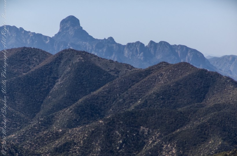
Here is a photograph from that day of Baboquivari Peak taken from Kitt Peak’
Baboquivari Peak is the most sacred place to the Tohono O’odham people. It is the center of the Tohono O’odham cosmology and the home of the creator, I’itoi. According to tribal legend, he resides in a cave below the base of the mountain. This mountain is regarded by the O’odham nation as the navel of the world – a place where the earth opened, and the people emerged after the great flood. Baboquivari Peak is also sometimes referred to as I’Itoi Mountain. In the native O’odham language, it is referred to as Waw Kiwulik, meaning “narrow about the middle”. The O’odham people believe that he watches over their people to this day. — Wikipedia
Baboquivari Peak was mentioned in the journals of Jesuit missionary Padre Kino, who made many expeditions into this region of the Sonoran Desert, beginning in 1699, establishing Spanish Missions in the area. — Wikipedia
Kitt Peak is in the sacred precinct of Baboquivari, the land just below the peak is the “Gardens of the Sacred Tohono O’odham Spirit I’itoi.” The month of my visit, the O’odham nation brought legal suit against Kitt Peak to halt construction of new telescopes in the garden. The issue was settled out of court.
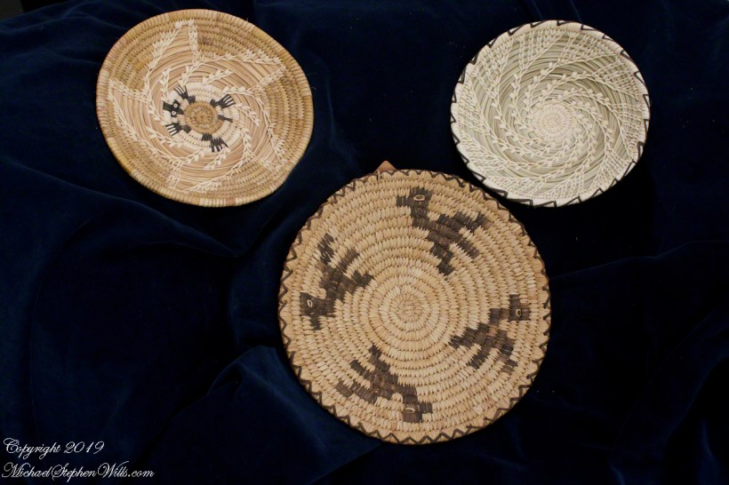
About the header photograph: From the bottom clockwise. Birds by Anmelia Juan of Geawuk (Kitt Peak 1972) – I purchased this from the Kitt Peak gift shop during my first visit; Turtle by Olvera and Simon Valenquela (Saguaro National Monument 2005); Stars by Simon Valenzuela for his daughter Pasquala Valenquela 16th Birthday (2018). Simon is of the Pascua Yaqui tribe who Learned basketmaking from his wife’s family.
Copyright 2022 Michael Stephen Wills All Rights Reserved