San Xavier del Bac, known as the “White Dove of the Desert,” embodies rich history and spirituality, blending Indigenous and Spanish influences, while remaining a vibrant community centerpiece today.
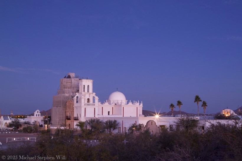
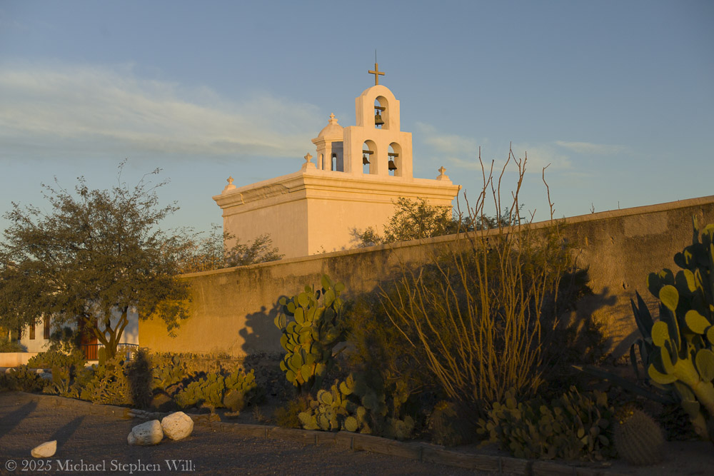
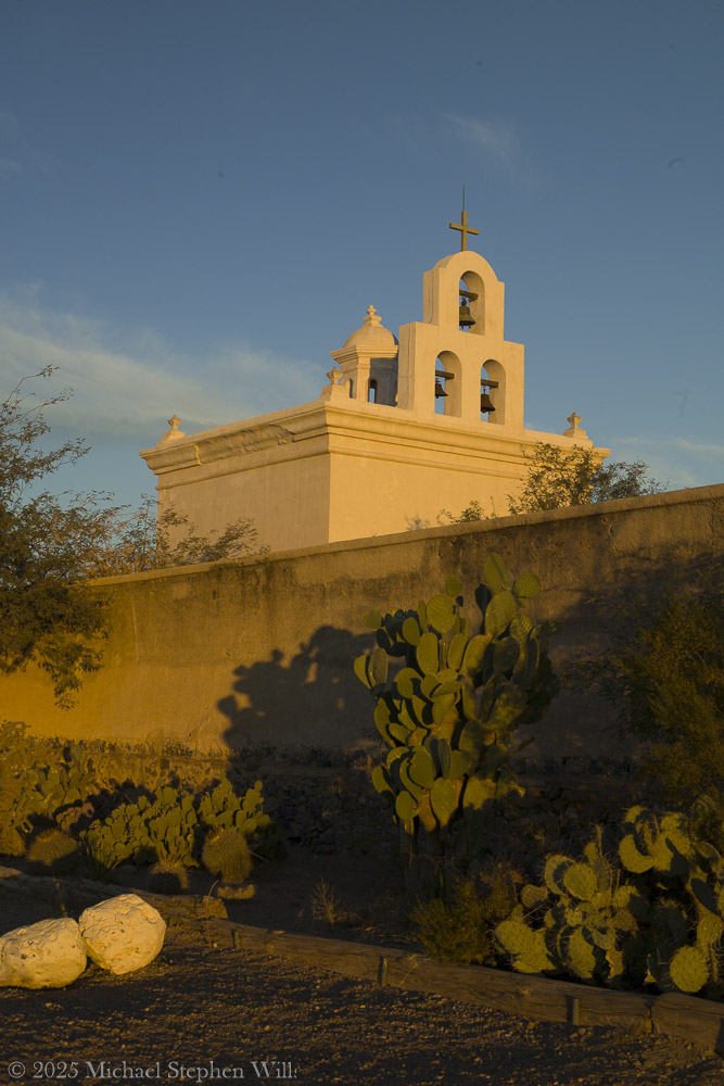
I remember how the rising sun washes the mission’s white adobe walls in soft gold. Mission San Xavier del Bac stands about 10 miles south of downtown Tucson, on the San Xavier Indian Reservation of the Tohono O’odham Nation.
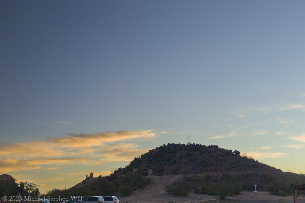
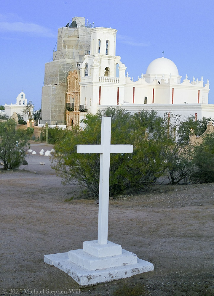
Before sunrise, I climb Grotto Hill, just east of the mission. A well-worn path and a few stone steps lead upward, passing stations of the cross and a humble grotto shrine nestled in the slope. As I ascend, the soft golden light gathers. Ocotillo stems and saguaros dot the hillside, their long shadows stretching over the desert floor. Reaching the top, I find a lone white cross planted firmly into the rocky soil. The cross is simple, yet it holds a quiet gravity – a silent witness to the prayers and hopes of those who have come here. I stand beside it to catch my breath. Below me spreads the mission complex, glowing white and rose in the gathering dawn. From this height, the scene is breathtaking: the desert expands in every direction, painted in brushstrokes of copper, violet, and gold. The distant Tucson mountains catch the first light. There is a profound peace up here. It’s easy to imagine Father Kino himself climbing a similar hill, surveying this “Water Place” and dreaming of a mission that would stand the test of time.
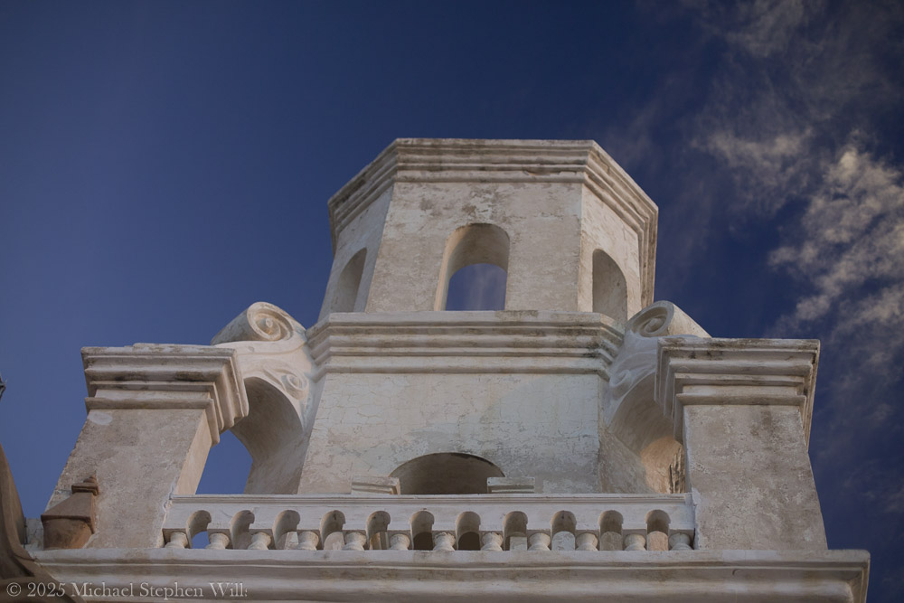
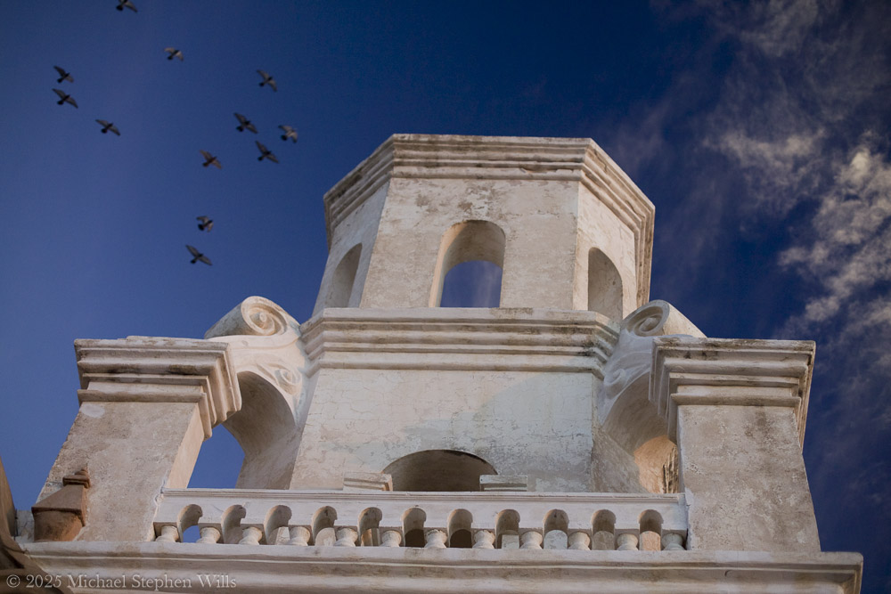
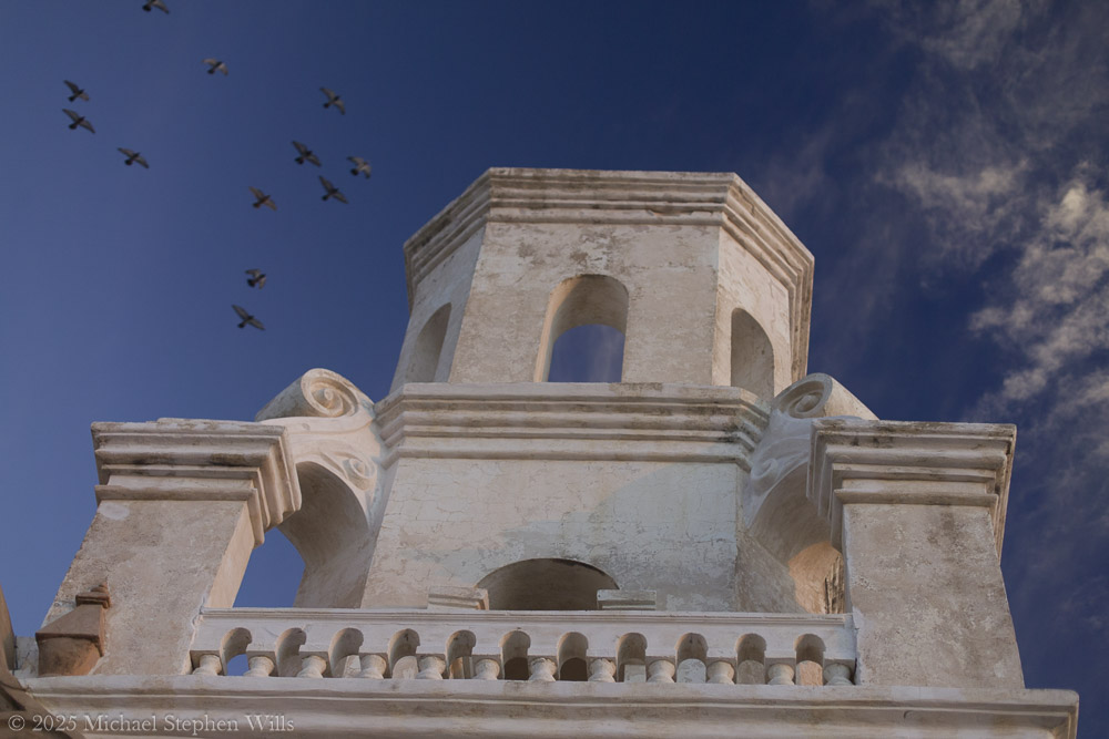
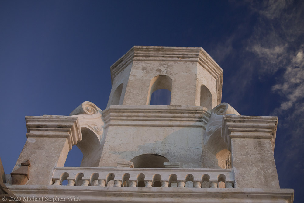
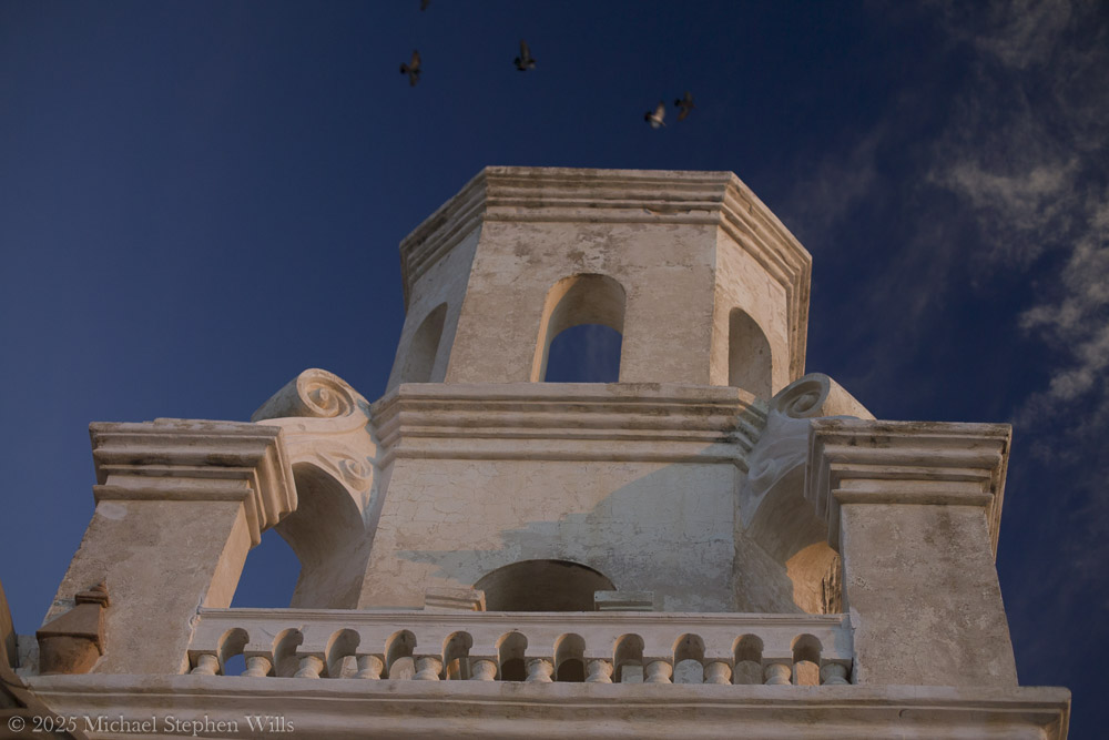
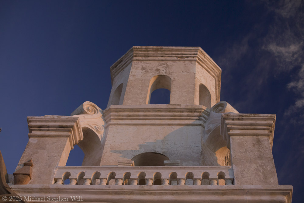
Often called the “White Dove of the Desert”the church gleams against the wide Sonoran sky, its twin bell towers and central dome radiant in the glow. In this moment, the 18th-century mission seems to hover between earth and heaven – a bright vision in the desert, tethered by history and faith.
I walk toward the old mission, feeling the crunch of desert sand beneath my feet and brushing past creosote bushes and prickly pear cacti. There is a hush here, broken only by a gentle breeze and the distant coo of a dove – as if nature itself respects the sanctity of this place. In my mind I rell that this mission was first founded in 1692 by the Jesuit missionary Father Eusebio Kino, who encountered the O’odham community living at this oasis they called Wa:k, meaning “Water Place”
The springs have long since gone dry, but the name lives on, a reminder that this now-arid land once nurtured life-giving water. The church before me isn’t the original Kino saw, but the one begun in 1783 under Spanish Franciscan friars who raised these walls with the help of O’odham artisans. I marvel that I am standing before a structure over two centuries old – the oldest European-built structure in Arizona– yet still alive with spirit.
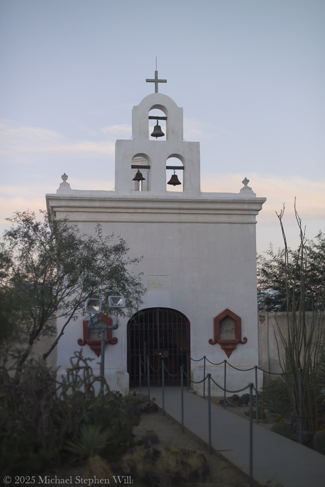
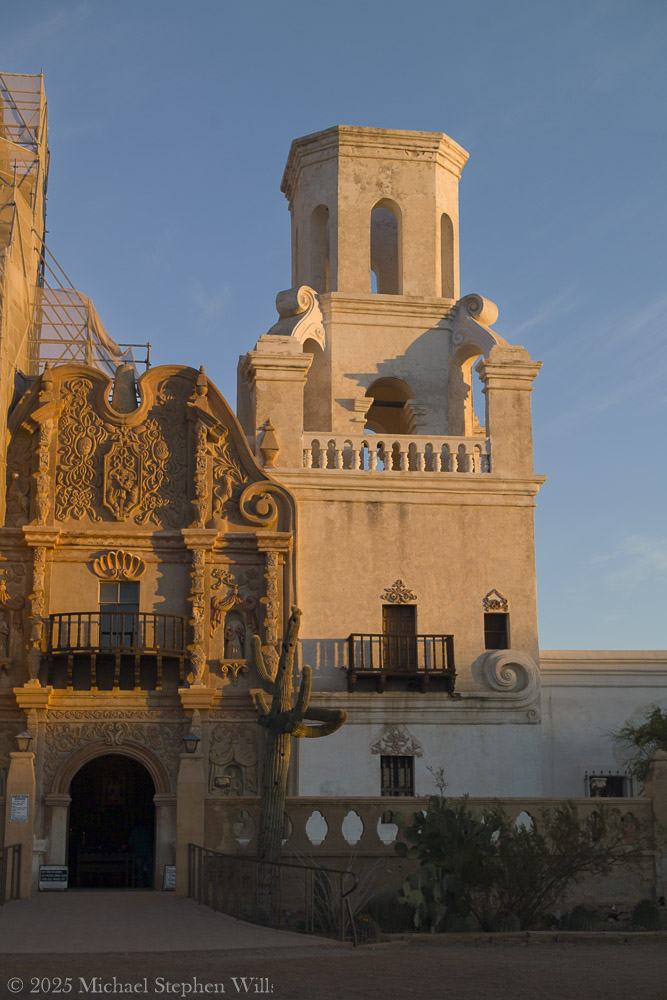
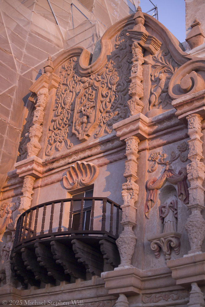
Stepping into the courtyard, I tilt my head back to absorb the facade’s details. The ornate Baroque façade is a symphony of carved plaster and painted relief, an exuberant blend of Moorish, Spanish, and Indigenous influences. Faded yet still vivid, saints and angels watch from their niches on the church front. Every arch and cornice is edged in shadow and dawn light, revealing craftsmanship considered one of the finest examples of Mexican Baroque architecture in the United States
The front entrance is flanked by intricate scrolls and whimsical carvings – floral motifs, seashell patterns, and statuary wearing serene expressions. I gently run my fingers along the weathered wooden doors, feeling the grain that generations of hands have touched. Through a crack in the door, I catch a glimpse of the dim interior: candles flicker on the altar and the air carries a hint of melted wax and sweet incense. Thesanctuary seems to exude centuries of devotion. Even outside, I sense a whisper of ancient prayers in the silence.
The Bell Tower in dawn light
As the day progresses, the world feels alive again. A pair of children laugh and chase each other across the dusty plaza, their voices echoing off the thick adobe walls. Nearby, the aroma of fresh frybread lingers – evidence of Tohono O’odham vendors who often set up stands by the church, selling frybread “popovers” and Indian tacos to visitors. This mingling of old and new, sacred and every day, makes the mission feel utterly genuine, the heart of a living community. I see an elderly O’odham woman in a shawl kneel at a side shrine, lips moving in quiet prayer, and I realize that for the Tohono O’odham, this mission is more than a historic landmark. It is a living spiritual home that continues to anchor their community. Indeed, the church is still an active parish that serves the local O’odham families, with regular Masses and gatherings held within its walls
The sense of continuity is palpable – the faith that built this place in the 18th century endures unwaveringly today.
Standing in front of San Xavier del Bac, I feel a personal connection that is hard to put into words. The centuries-old mission glows fresh in morning light. I close my eyes and sense the presence of all who have been here before – the O’odham villagers, the Spanish padres, the countless pilgrims and visitors. In the stillness, time blurs. Past and present mingle in the desert air. When I finally turn to leave, my heart is quiet, uplifted by the encounter. In this sacred and remote place, I have touched a living history and felt the embrace of a peace that transcends centuries. I carry that gentle peace with me into the day, grateful for the memories of light, silence, and the enduring soul of San Xavier del Bac.
Bibliography
Wikipedia. “Mission San Xavier del Bac.” (2025).
National Park Service. “San Xavier del Bac Mission.” (2021).
Patronato San Xavier. “History of the Mission – Timeline.” (2025).
Arcosanti, envisioned by Paolo Soleri, exemplifies sustainable urban living but faces challenges in realization, scalability, and contemporary relevance.
Arcosanti, the brainchild of architect Paolo Soleri, was conceived as an experimental laboratory for urban design and ecological principles—a built embodiment of his vision of Arcology (a fusion of “architecture” and “ecology”). Over fifty years since its groundbreaking in 1970, Arcosanti remains a significant cultural and architectural artifact. However, the meaning and relevance of both Arcosanti and Arcology in today’s context invite critical examination.
The accompanying photographs are a presentation of the history of Arcology from Arcosanti signage
Arcosanti 5000 — Soleri’s Ultimate Vision
Historical Context and the Vision of Arcology
Soleri’s concept of Arcology emerged during the mid-20th century, an era of increasing environmental awareness, urban sprawl, and population growth. His vision was radical: compact, self-sustaining urban environments that minimized ecological impact while fostering human interaction and creativity. Arcology sought to challenge the sprawling, resource-intensive models of urban development that dominate the modern world.
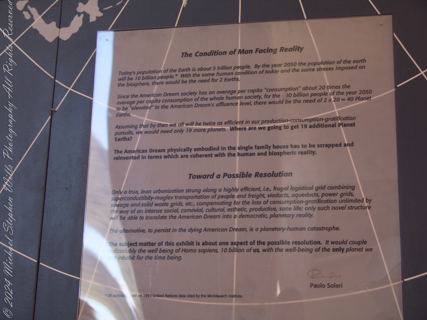
Today’s population of the Earth is about 5 billion people. By the year 2050 the population of the Earth will be 10 billion people.* With the same human condition of today and the same stresses imposed on the biosphere, there would be the need for 2 Earths.
Since the American Dream society has an average per capita “consumption” about 20 times the average per capita consumption of the whole human society, for the 10 billion people of the year 2050 to be “elevated” to the American Dream’s affluence level, there would be the need of 2 x 20 = 40 Planet Earths.
Assuming that by then we all will be twice as efficient in our production-consumption-gratification pursuits, we would need only 19 more planets. Where are we going to get 19 additional Planet Earths?
The American Dream physically embodied in the single-family house has to be scrapped and reinvented in terms which are coherent with the human and biospheric reality.
Toward a Possible Resolution
Only a true, lean urbanization strung along a highly efficient, i.e., frugal logistical grid combining superconductivity-maglev transportation of people and freight, viaducts, aqueducts, power grids, sewage and solid waste grids, etc., compensating for the loss of consumption-gratification unlimited by the way of an intense social, convivial, natural, esthetic, productive, sane life; only such novel structure will be able to translate the American Dream into a democratic, planetary reality.
The alternative, to persist in the dying American Dream, is a planetary-human catastrophe.
The subject matter of this exhibit is about one aspect of the possible resolution. It would couple indissolubly the well-being of Homo sapiens, 10 billion of us, with the well-being of the only planet we can inhabit for the time being.
All statistics based on 1993 United Nations data cited by the Worldwatch Institute.
(signed) Paolo Soleri
Arcosanti was intended to be a prototype—a proof of concept for dense urban living within a minimal environmental footprint. Its design embraced verticality, integration with natural surroundings, and multi-use spaces to reduce resource consumption. Soleri’s philosophy rejected wasteful consumerism and emphasized communal living, self-sufficiency, and harmony with nature.
Arcosanti as a Realization of Arcology
While Soleri’s ideas were visionary, Arcosanti itself never fully realized its original ambitions. Planned to house 5,000 people, it currently accommodates fewer than 100 residents. This gap between aspiration and reality reflects several challenges:
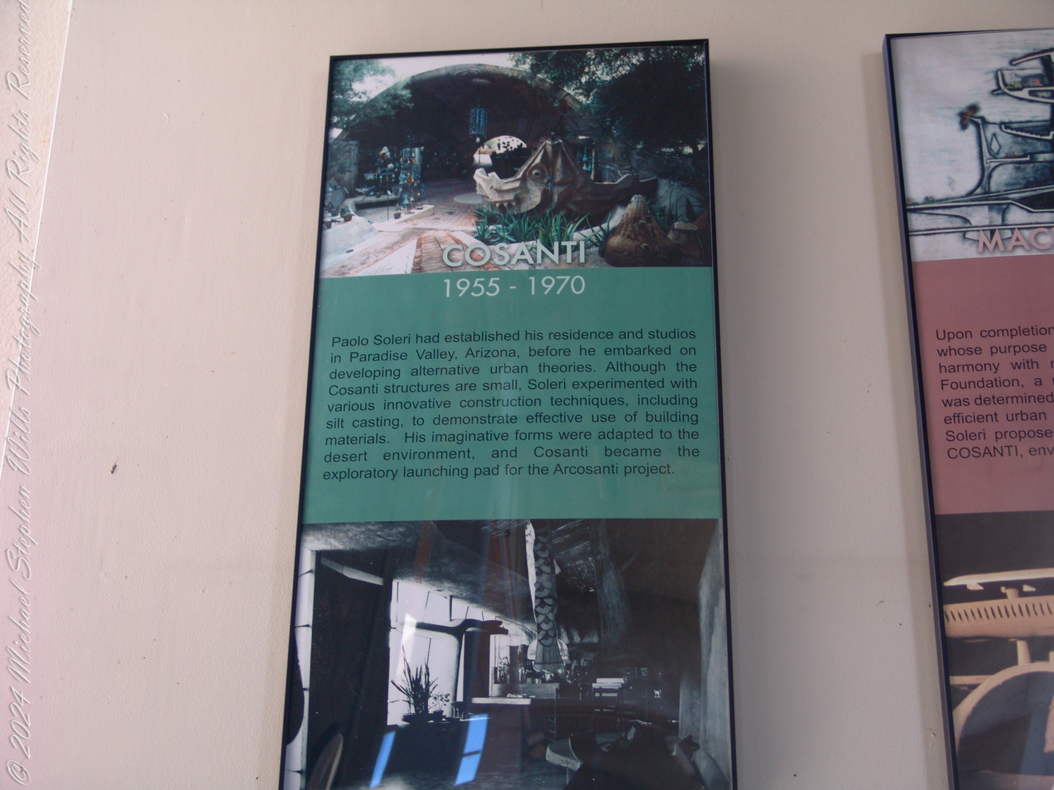
Paolo Soleri had established his residence and studios in Paradise Valley, Arizona, before he embarked on developing alternative urban theories. Although the Cosanti structures are small, Soleri experimented with various innovative construction techniques, including silt casting, to demonstrate effective use of building materials. His imaginative forms were adapted to the desert environment, and Cosanti became the exploratory launching pad for the Arcosanti project.
Scale and Funding: Building a sustainable community of this scale required vast financial and organizational resources. Arcosanti, largely constructed through volunteer labor and workshops, lacked the momentum to expand at the pace Soleri envisioned.
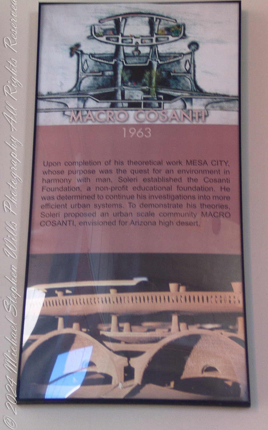
Upon completion of his theoretical work MESA CITY, whose purpose was the quest for an environment in harmony with man, Soleri established the Cosanti Foundation, a non-profit educational foundation. He was determined to continue his investigations into more efficient urban systems. To demonstrate his theories, Soleri proposed an urban-scale community MACRO COSANTI, envisioned for Arizona high desert.
Cultural Shifts: The communal living and austerity championed by Soleri contrast sharply with the consumer-driven values of contemporary society. The rise of globalized capitalism, suburban expansion, and digital individualism has made the communal ethos less appealing to many.
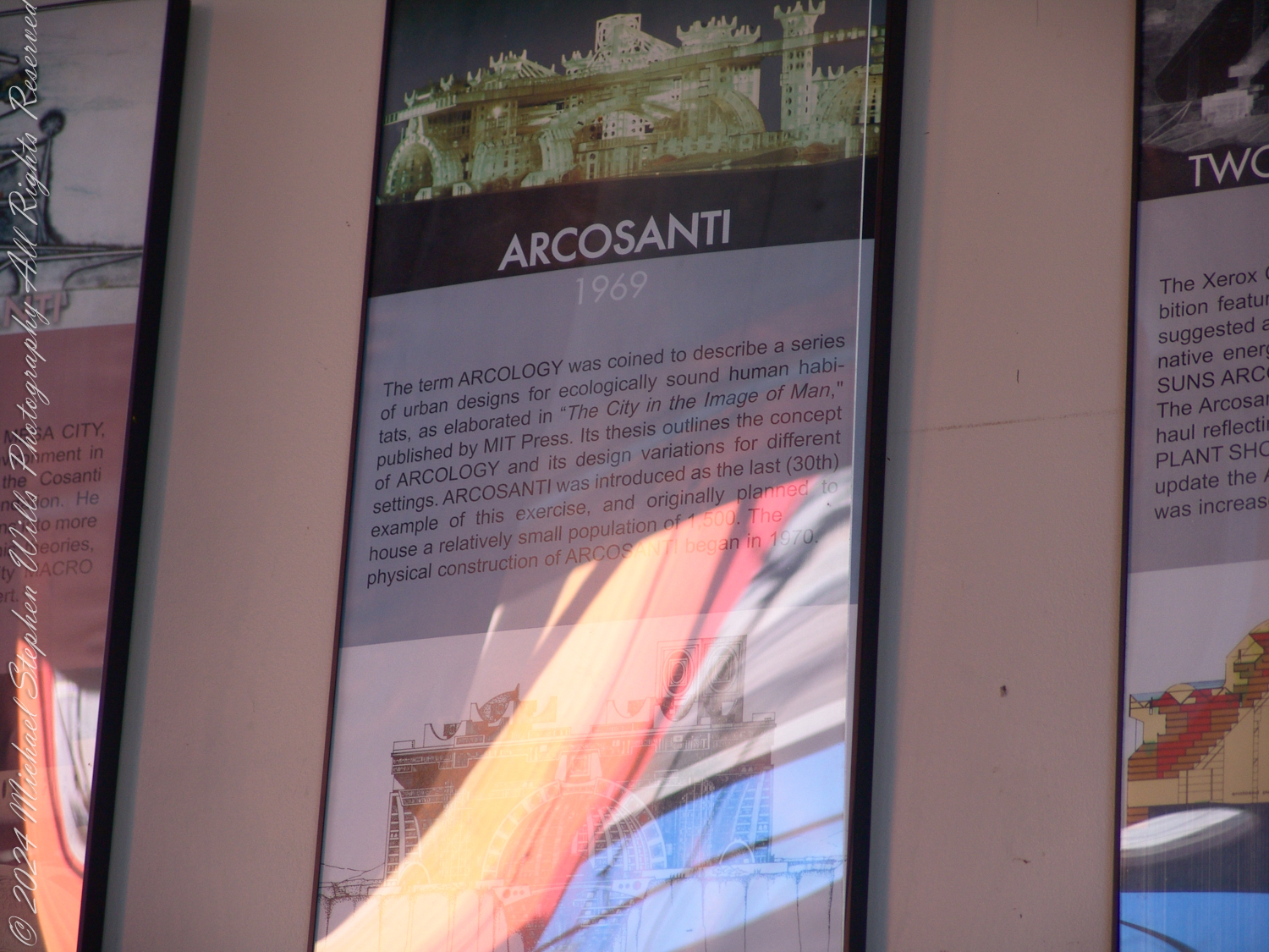
The term ARCOLOGY was coined to describe a series of urban designs for ecologically sound human habitats, as elaborated in “The City in the Image of Man,” published by MIT Press. This thesis outlines the concept of ARCOLOGY and its design variations for different settings. ARCOSANTI was introduced as the last (30th) example of this exercise, and originally planned to house a relatively small population of 500. The physical construction of ARCOSANTI began in 1970.
Technological Advances: Soleri’s designs were innovative for their time, but modern advancements in sustainable technology—such as solar power, green building materials, and decentralized energy systems—have surpassed some of his ideas. Today, sustainable urbanism focuses on retrofitting existing cities rather than building entirely new ones.
The Relevance of Arcology Today
Despite its limitations, Arcology remains profoundly relevant in the face of 21st-century challenges such as climate change, resource scarcity, and urban overpopulation. Soleri’s principles offer a framework to address these crises, particularly through:
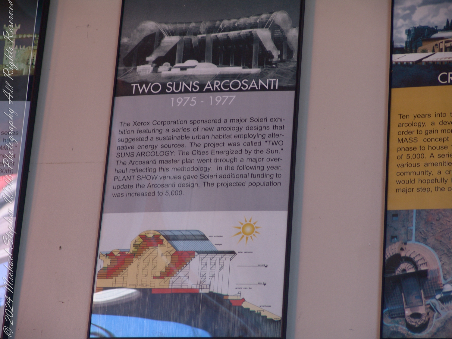
The Xerox Corporation sponsored a major Soleri exhibition featuring a series of new arcology designs that suggested a sustainable urban habitat employing alternative energy sources. The project was called “TWO SUNS ARCOLOGY: The Cities Energized by the Sun.” The Arcosanti master plan went through a major overhaul reflecting this methodology. In the following year, PLANT SHOW venues gave Soleri additional funding to update the Arcosanti design. The projected population was increased to 5,000.
Compact Urbanism: Cities worldwide are grappling with the environmental toll of urban sprawl. Arcology’s emphasis on vertical, compact cities with reduced land usage aligns with the modern push for urban densification.
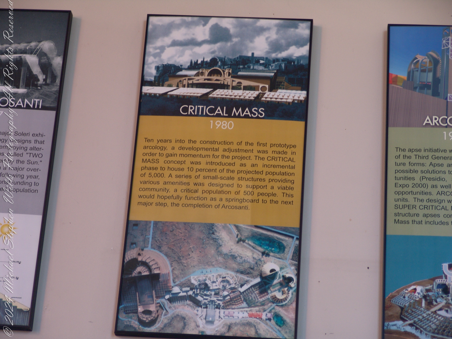
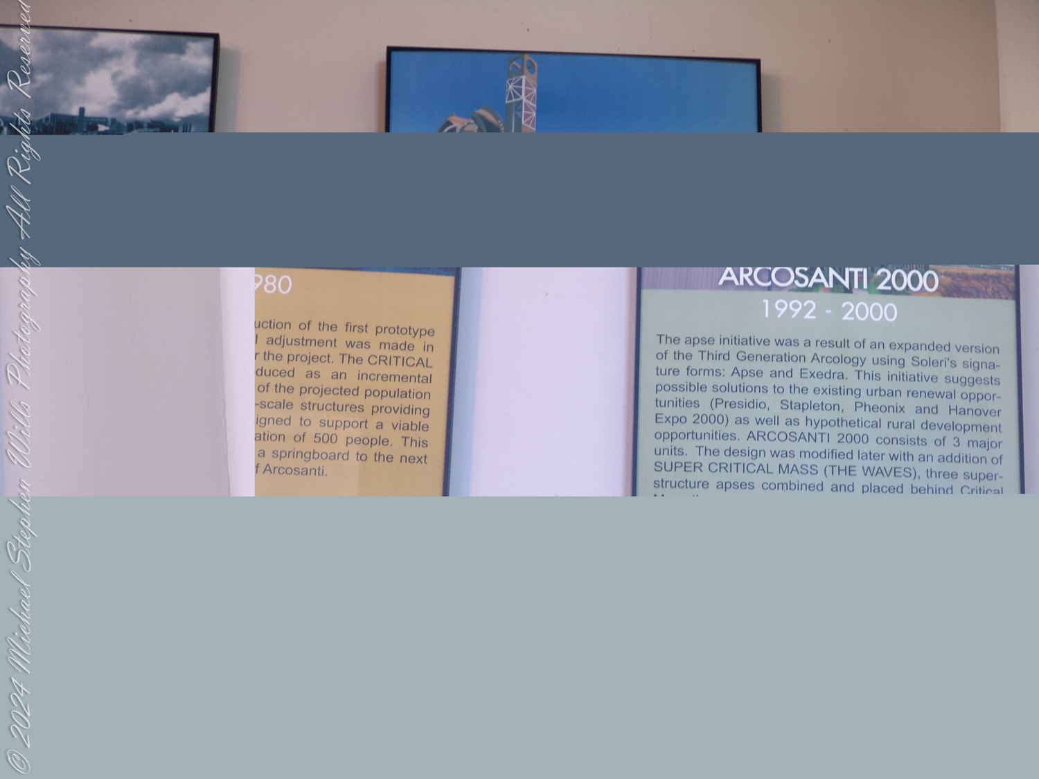
Ten years into the construction of the first prototype arcology, a developmental adjustment was made in order to gain momentum for the project. The CRITICAL MASS concept was introduced as an incremental phase to house 10 percent of the projected population of 5,000. A series of small-scale structures providing various amenities was designed to support a viable community, a critical population of 500 people. This would hopefully function as a springboard to the next major step, the completion of Arcosanti.
Mixed-Use and Communal Spaces: The COVID-19 pandemic underscored the importance of walkable, mixed-use neighborhoods and shared green spaces. Arcology’s model of integrated living and working spaces anticipates these needs.
Sustainability and Circular Systems: Soleri’s focus on minimizing waste and resource use aligns with today’s circular economy principles. Arcology’s ideas resonate with efforts to design cities as closed-loop systems that reuse resources.
The apse initiative was a result of an expanded version of the Third Generation Arcology using Soleri’s signature forms: Apse and Exedra. This initiative suggests possible solutions to the existing urban renewal opportunities (Presidio, Stapleton, Phoenix, and Hanover Expo 2000) as well as hypothetical rural development opportunities. ARCOSANTI 2000 consists of 3 major units. The design was modified later with an addition of SUPER CRITICAL MASS (THE WAVES), three superstructure apses combined and placed behind Critical …
A Philosophical Challenge: Beyond practical urban design, Arcology challenges us to rethink our relationship with the planet and with each other. It invites a fundamental shift from individualistic consumption to collective stewardship.
Critique of Arcosanti Today
Arcosanti, while iconic, serves more as a symbol than a fully functioning example of Arcology. Its limited population and incomplete development highlight key shortcomings:
Lack of Scalability: Arcosanti has not demonstrated how Arcology principles can scale to meet the needs of modern cities with millions of inhabitants.
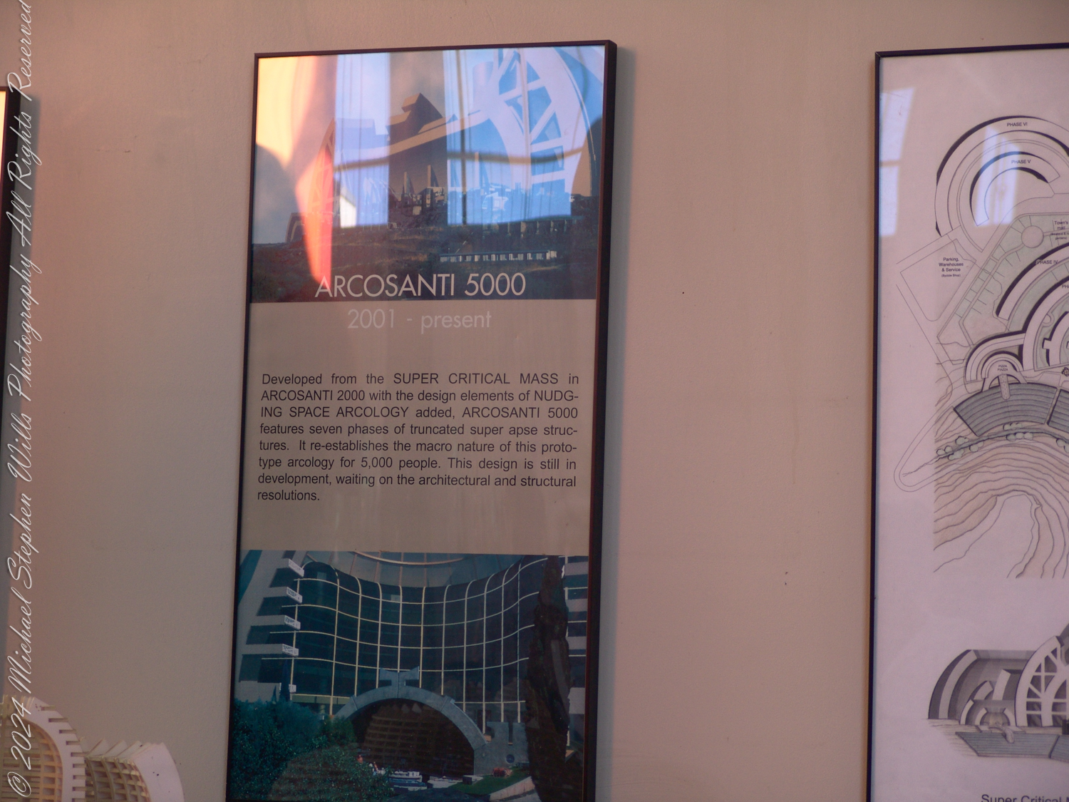
ARCOSANTI 5000
2001 – present
Developed from the SUPER CRITICAL MASS in ARCOSANTI 2000 with the design elements of NUDGING SPACE ARCOLOGY added, ARCOSANTI 5000 features seven phases of truncated superapse structures. It re-establishes the macro nature of this prototype arcology for 5,000 people. This design is still in development, waiting on the architectural and structural resolutions.
Dependence on External Systems: Despite its aspirations for self-sufficiency, Arcosanti relies on external power grids, supply chains, and tourism, which limits its autonomy.
Cultural Niche: Arcosanti appeals primarily to a niche audience of artists, architects, and environmentalists, making it less accessible or appealing to broader populations.
However, these critiques do not negate its value as a learning tool. Arcosanti’s enduring presence serves as a physical and philosophical case study for those seeking alternatives to conventional urbanism.
A Way Forward?
The future of Arcology lies not in building new Arcosanti-like prototypes but in applying its principles to existing cities and communities. Initiatives such as urban vertical farming, passive solar building design, and car-free city centers echo Soleri’s vision in modern contexts.
Additionally, Arcosanti itself could pivot toward becoming a research hub for sustainable practices, a cultural landmark, or a retreat for those seeking inspiration in Soleri’s ideas. By focusing on education and experimentation, it could remain relevant in contemporary discussions about urbanism and ecology.
Conclusion
Arcosanti and Arcology are more than relics of a bygone architectural movement—they are reminders of humanity’s potential to live in balance with nature. While the practical implementation of Arcology faces significant hurdles, its core philosophy continues to inspire efforts to create more sustainable and harmonious urban environments. In a world increasingly shaped by environmental urgency, Soleri’s vision holds lessons we cannot afford to ignore.
Enter your email to receive notification of future postings. I will not sell or share your email address.
Copyright 2024 All Rights Reserved Michael Stephen Wills
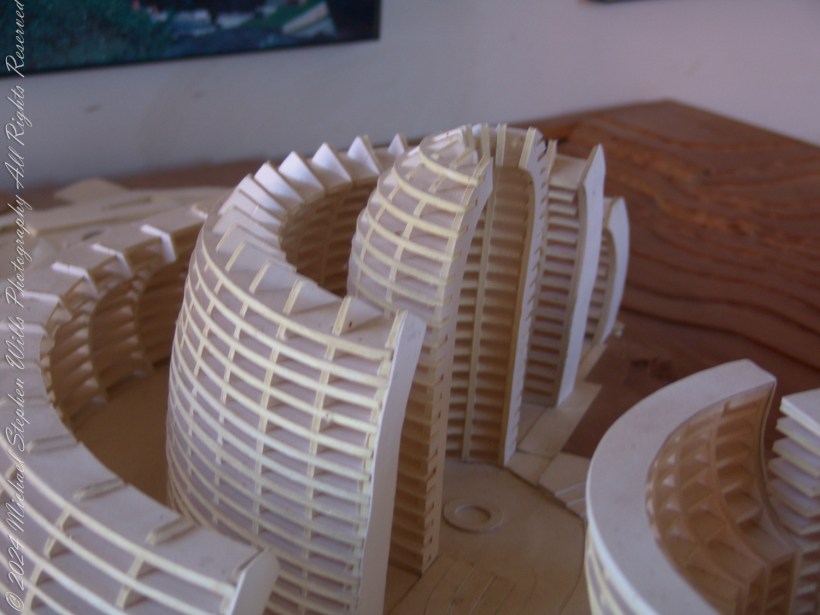
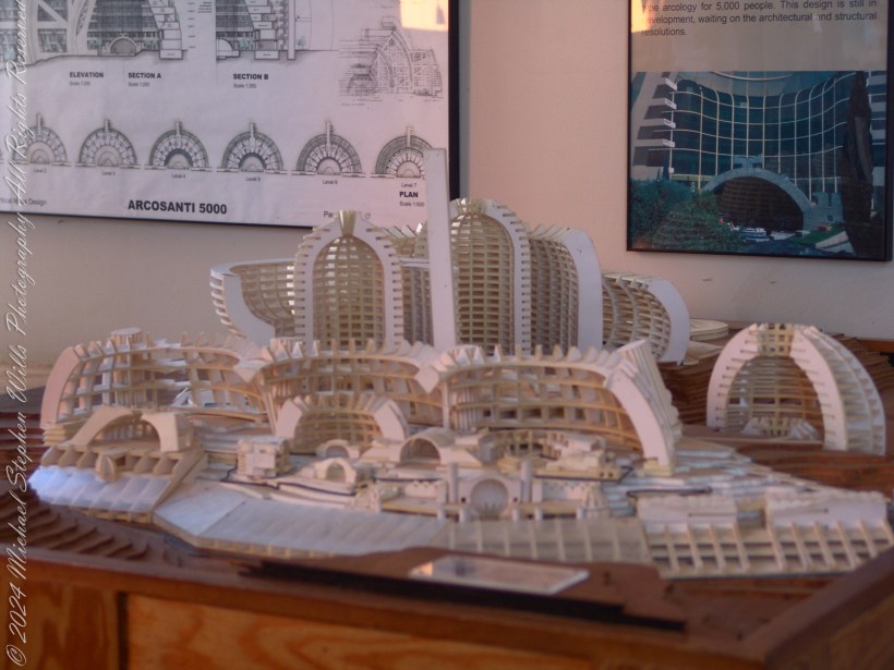
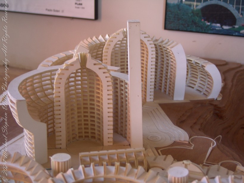
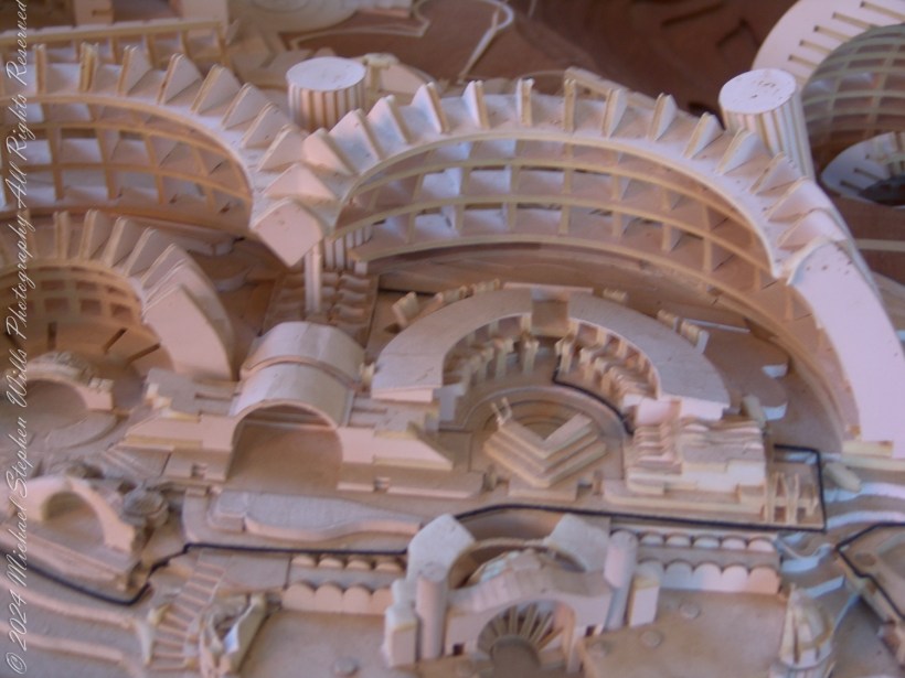
The desert air was sharp, dry, and oddly invigorating as I stepped into the gallery at Arcosanti, Arizona. The year was 2005, and I had long dreamed of visiting this experimental micro-city—a fusion of architecture and ecology conceived by Paolo Soleri. Amidst the array of sketches, photographs, and miniature prototypes stood the centerpiece of my curiosity: the sprawling, intricate scale model of “Arcosanti 5000.” It was as though the future had been condensed into a tangible artifact, whispering promises of an alternative way of living.
The model was perched on a wooden table, surrounded by blueprints and diagrams. Its sweeping curves and layered structures evoked the natural patterns of a canyon or the unfurling petals of a desert flower. I leaned in, drawn to its labyrinthine details: the arches that seemed to embrace the air itself, the layered grids suggesting terraces and communal spaces, and the towering central spire—a striking focal point that anchored the design. The model was an architectural plan, a vision made tactile, a conversation between the human spirit and the earth it inhabits.
As I circled the table, I tried to imagine life within these walls. Here was the apse architecture that Soleri had championed—a structural form both futuristic and deeply rooted in the land. Its curves seemed to reject the cold rigidity of modern urbanity, embracing instead a harmonious fluidity. What would it feel like to wake up in one of these units, to look out through those sweeping arches and see the desert alive with light and shadow?
The plaque nearby described this design as part of a “Super Critical Mass” initiative, envisioned for a population of 5,000. The model represented an evolution from earlier prototypes, incorporating what Soleri called “nudging spaces”—areas designed to encourage spontaneous human interaction. I thought of my own neighborhood back home, how it felt fractured and isolated by its grids of asphalt and fenced-off yards. Could this model offer a blueprint for healing that divide?
I moved closer, tracing the pathways with my eyes. The tiny staircases, the shaded atriums, the terraced gardens—they spoke of a life integrated with nature, of a city that tread lightly upon its environment. The thought was thrilling, but also sobering. The challenges of realizing such a vision in the sprawling chaos of modern development loomed large in my mind. Could humanity ever truly embrace such radical simplicity?
In that moment, the gallery was silent except for the soft click of my camera. I wanted to capture not just the model, but the feeling it evoked—the delicate balance of hope and humility. The metadata on the image files would later remind me of the precise day and hour I stood there, absorbing this vision of what might be. But no timestamp could fully capture the spark it ignited—a sense that, even in a world burdened by consumption and waste, there remained a path forward, winding like a desert trail through arches of light and shadow.
Enter your email to receive notification of future postings. I will not sell or share your email address.
Copyright 2024 All Rights Reserved Michael Stephen Wills
The Pulse Bridge model embodies Paolo Soleri’s vision, merging architecture and philosophy to inspire adaptability, connection, and beauty in urban landscapes.
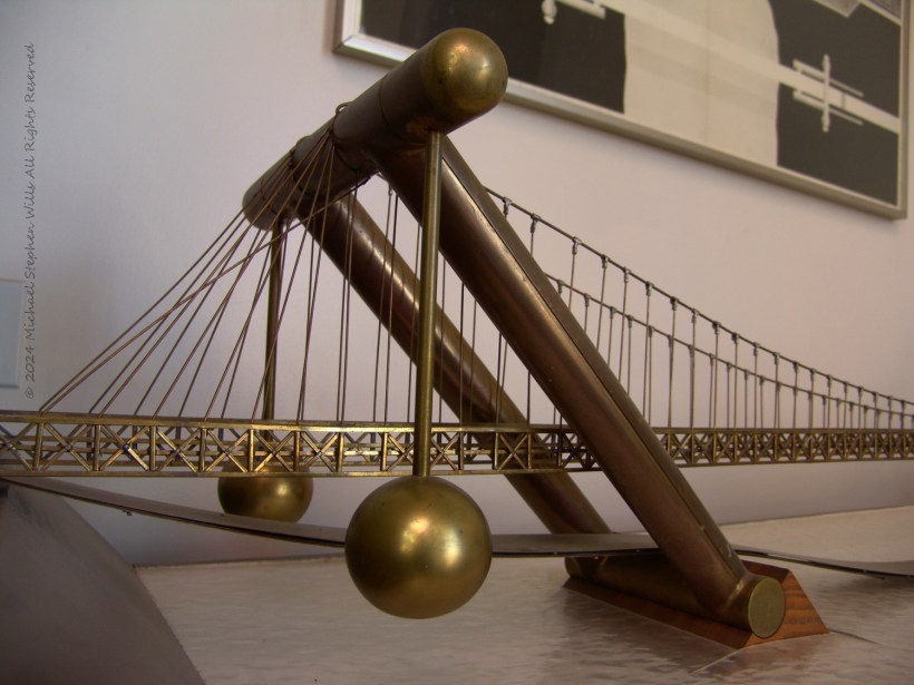
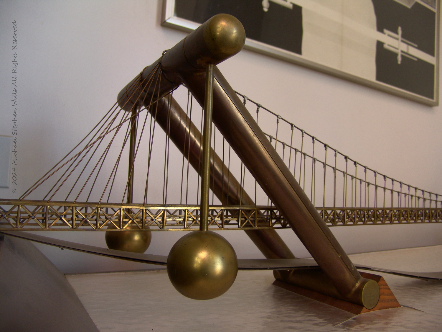
For me room was hushed, as if holding its breath in reverence for the dreams of a man who dared to reimagine not just buildings, but entire landscapes. I stood before the model of the Pulse Bridge, a work envisioned by the inimitable architect and philosopher Paolo Soleri. This was a living, breathing entity in miniature—a whisper of the city’s heartbeat rendered in metal and form.
PULSE BRIDGE is conceived for the New York cityscape and designed so as to alter its own stress configuration according to the traffic loads it carries and the temperature and wind variations. It does not so much react to such stresses as it dynamically adapts to them. This is achieved by suspending the whole structure on two sets of hinges and altering the weight distribution by way of four ballast spheres, constantly changing in weight because of the water volume they contain and is pouring in or spilling out of each. Temperature differential and wind loads will suggest asymmetrical ballast content.
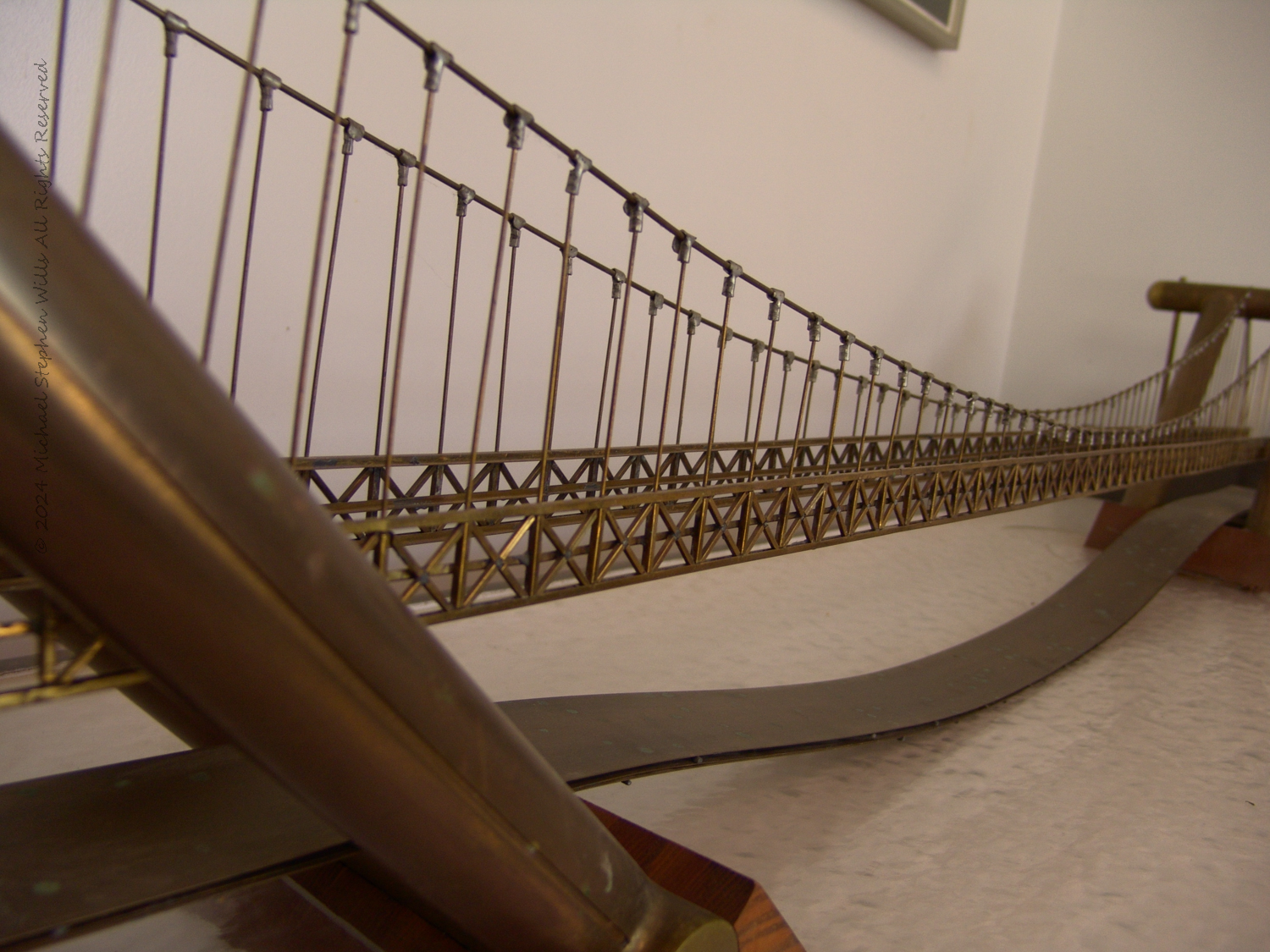
The bridge stretched across the table, a golden ribbon suspended in perpetual motion. Its delicate cables, taut and slender, mirrored the veins of a great urban organism. I leaned closer, catching the glint of light on the brass framework, which seemed to hum with possibility. The slanted pylons, bold and angled at 45 degrees, rose like colossal compass points charting a path into a future yet unbuilt. Their elegant incline gave the structure a sense of poise and power, as though it were both rooted in the earth and ready to leap skyward.
At either end of the model, spherical ballast weights gleamed like captive suns, their surfaces smooth and luminous. These orbs symbolized adaptability, a dynamic response to the unpredictable forces of wind, weight, and weather. Soleri’s genius was palpable in these spheres—each a small, controlled impulse that could tip, pour, or hold water to balance the bridge’s pulse, much like the human heart adjusts its rhythm to life’s demands.
As I circled the model, I noticed how the bridge’s levels—three distinct layers—seemed to invite a diversity of life. The uppermost level promised a vista for pedestrians and the rhythmic flow of cars. Beneath, a middle layer hinted at a mix of vehicles and trucks, and the lowest level seemed destined for the silent hum of trains, utilities, and unseen infrastructure. It was a symphony of movement, each level contributing its own notes to the city’s harmony.
And yet, the most captivating feature was not the mechanics or the engineering marvels, but the philosophy embedded within. Soleri’s vision was not just to build a bridge, but to craft an experience—a structure that could breathe, flex, and adapt to the ever-changing pulse of New York. He imagined the pylons as cultural hubs, housing optical museums, exhibitions on bridge history, and even gift shops. The bridge was as much about connecting people as it was about connecting places.
Standing there, I felt the weight of Soleri’s ambition. The Pulse Bridge was a manifesto, a declaration that utilitarian structures could inspire wonder and nurture life. I imagined walking across its span, the city stretching out on either side, the bridge subtly shifting beneath my feet as it responded to the flow of traffic and the gusts of wind. It would be a conversation between structure and environment, a dialogue that reminded me of the living world we so often take for granted.
The longer I stood before the model, the more I realized it was not just a reflection of Soleri’s imagination but a challenge to our own. Could we build a future where beauty and function danced together, where even a bridge could sing of resilience and grace? The Pulse Bridge dared us to try.
In that quiet room, with sunlight streaming through the windows and casting delicate shadows across the model, I felt the profound allure of what could be. Soleri’s bridge was an idea—a luminous thread connecting visionaries across time, urging us all to dream bigger, build better, and embrace the pulse of life in all its complexity.
Enter your email to receive notification of future postings. I will not sell or share your email address.
Copyright 2024 All Rights Reserved Michael Stephen Wills
Under a strong early spring desert sun I turned from Arcosanti Road, a ribbon of asphalt threading through the arid Arizona landscape. Ahead, the architectural vision of Paolo Soleri emerged like an oasis of ideas etched into the barren desert. My mind drifted back to the 1970s, to the University of Arizona lecture hall where Soleri, full of vigor, had introduced us to his concept of “Arcology.” That hour left an indelible mark—a vision of dense human habitation harmonizing with the environment, reducing our ecological footprint toward a sustainable whole.
Arcosanti detail
That memory had stayed with me, a beacon of idealism. Over the years, Soleri’s Arcosanti had grown, not with the speed of cities, but with the deliberate rhythm of an organic organism. Today, after decades of curiosity and connection, I found myself at its gates.
Click any photograph to visit my “Arizona” online gallery.
Pam checking her equipment before a Summer 2008 visit
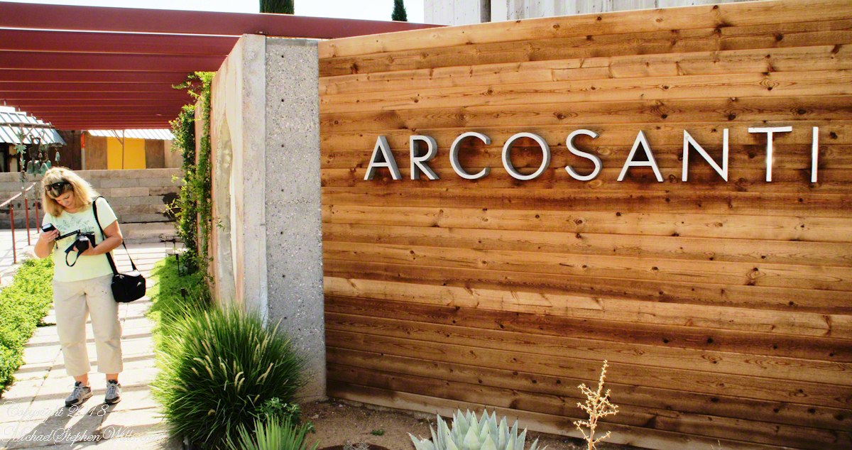
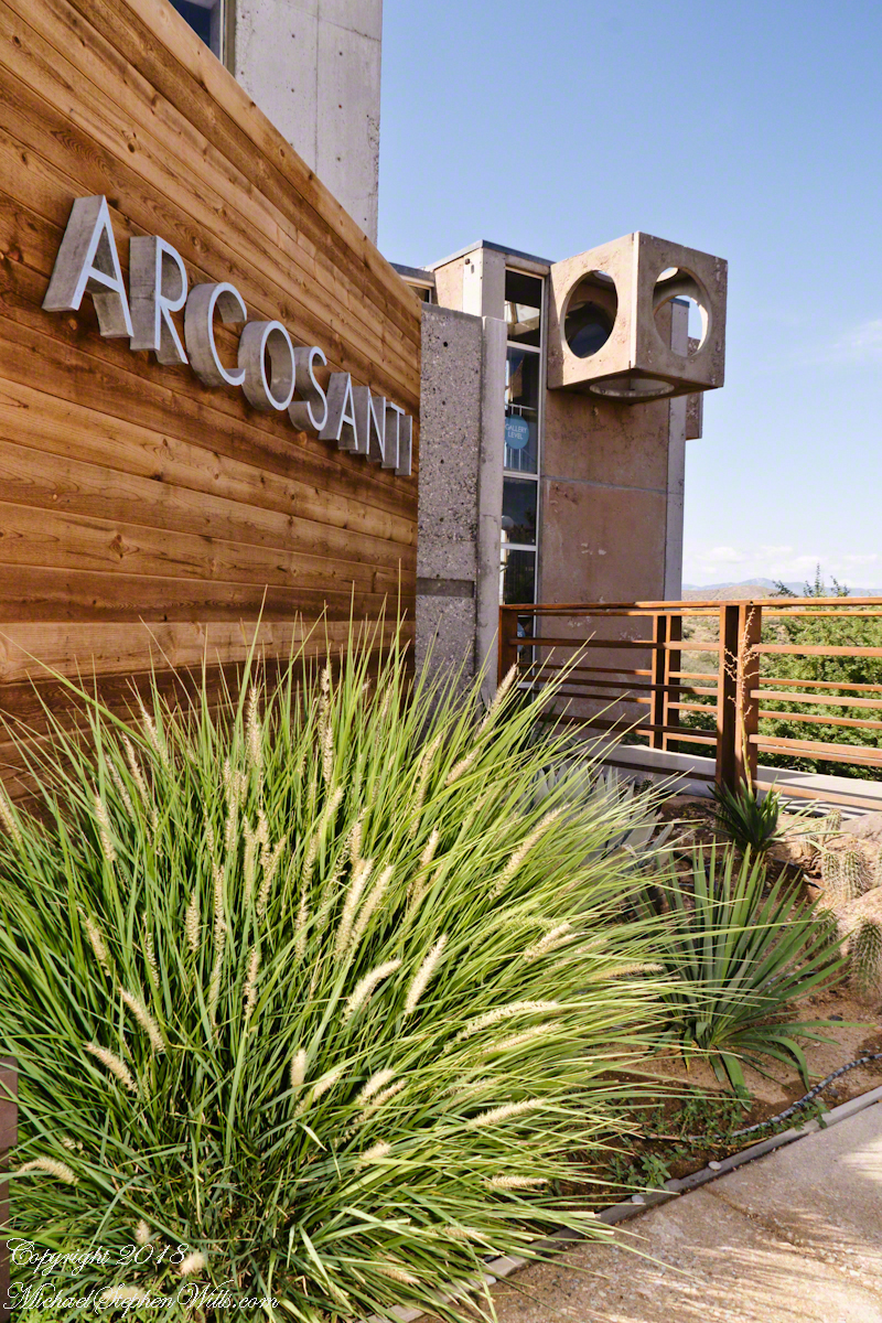
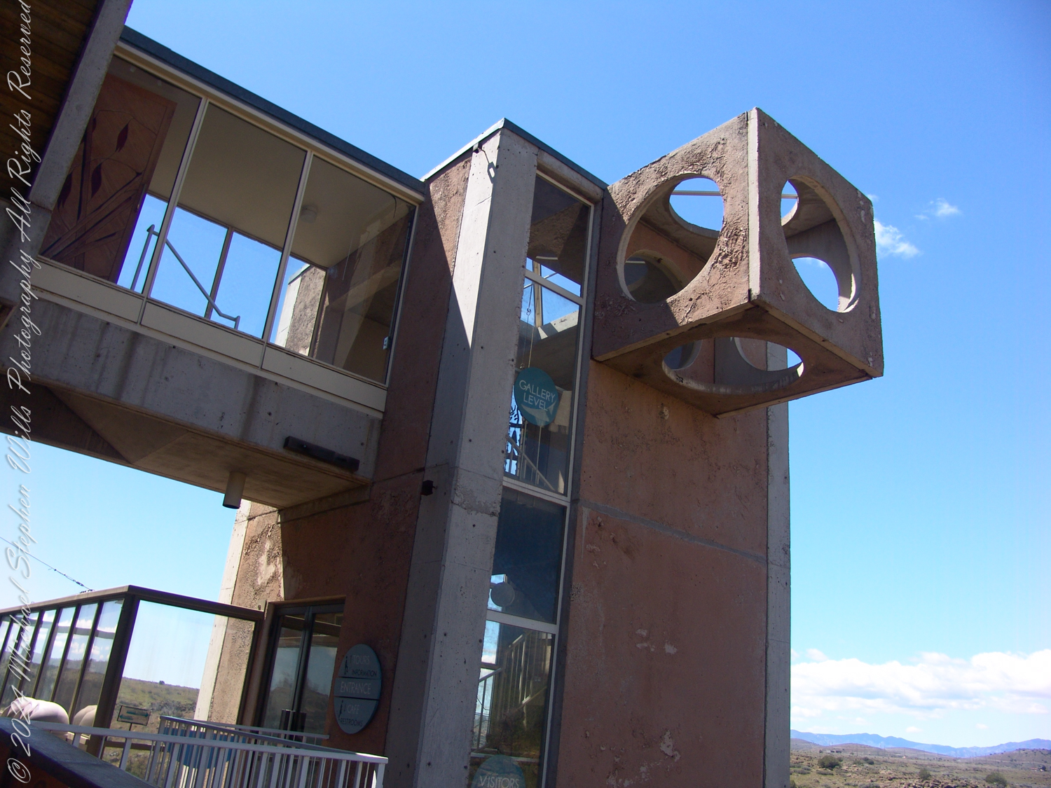
The first steps into Arcosanti struck me with a sense of balance. A sign, simple yet bold, announced the name: ARCOSANTI. It was embedded into a wooden facade, juxtaposed with the rugged modernity of concrete forms. Below, soft plumes of desert grass swayed, echoing the harmony Soleri envisioned—a human footprint gently integrated into the natural world. The sunlit entrance spoke of the potential for design to soothe rather than overpower.
Entrance and a Tower of the Crafts III building
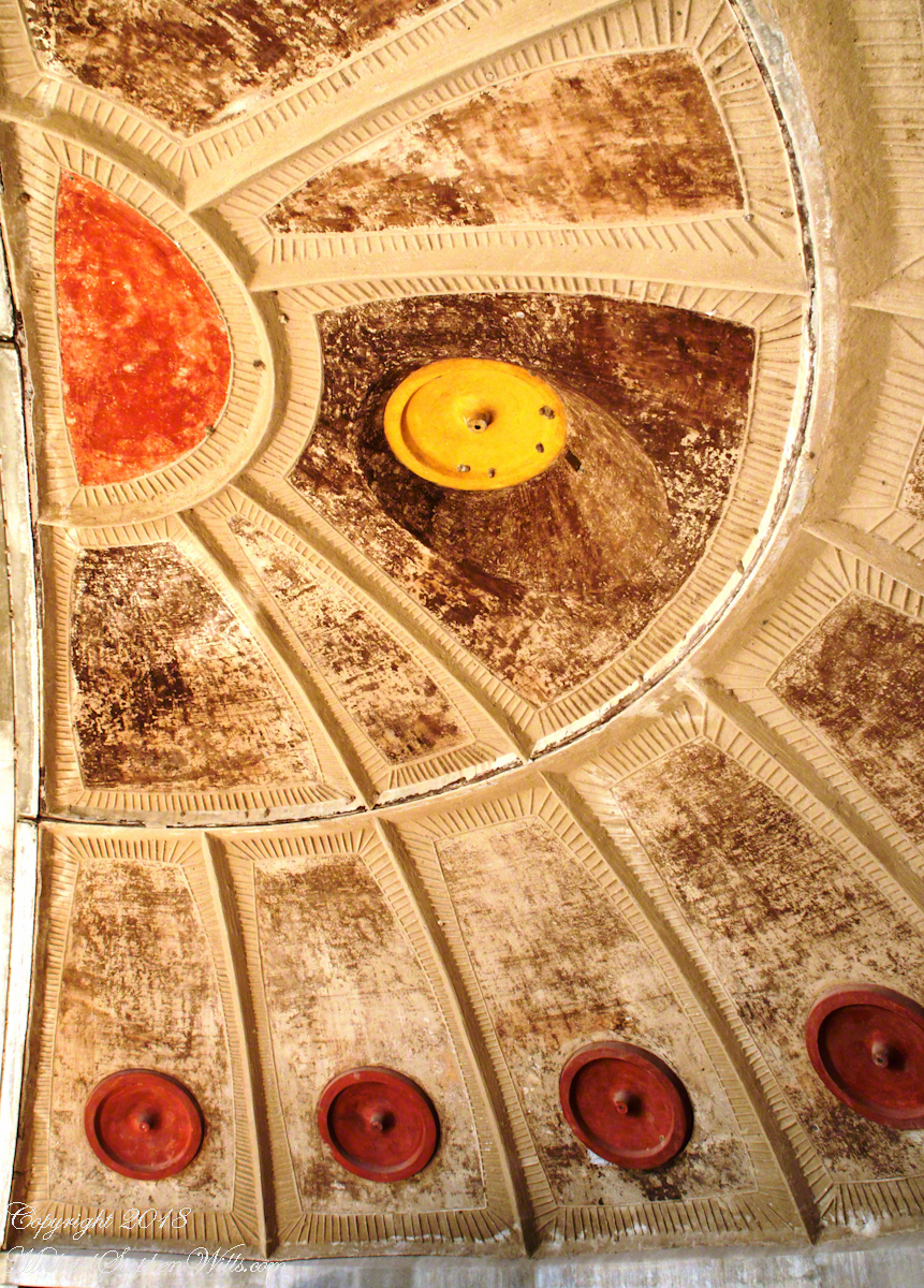
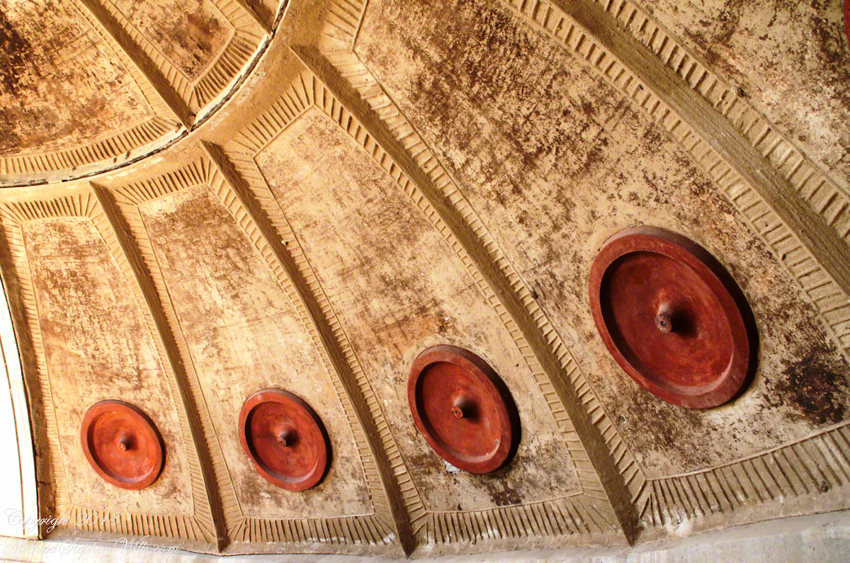
Inside, the bold lines and unique details captivated me. In one space, I craned my neck to admire a ceiling adorned with terracotta-colored circular forms, each embedded in angular panels radiating like the sun’s rays. These circular elements acted as focal points, their symmetry grounding the expansive, textured design. The play of light and shadow across the surface was mesmerizing, a reminder of Soleri’s mastery in turning the utilitarian into the poetic.
Ceramics Apse Sand Cast Panels I
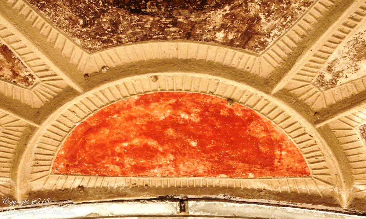
Each space in Arcosanti seemed crafted to evoke reflection. A splash of ochre-red pigment adorned another portion of the ceiling, forming a half-circle bordered by precise ridges. It was more than architectural detail—it was an abstract sun, warm and full of energy, radiating from its place above. The deliberate asymmetry, the interplay of form and texture, seemed to breathe with the desert itself.
Ceramics Apse Sand Cast Panels II
Ceramics Apse Sand Cast Panels III
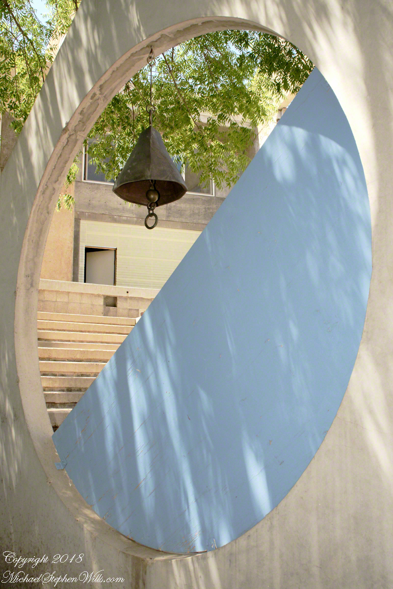
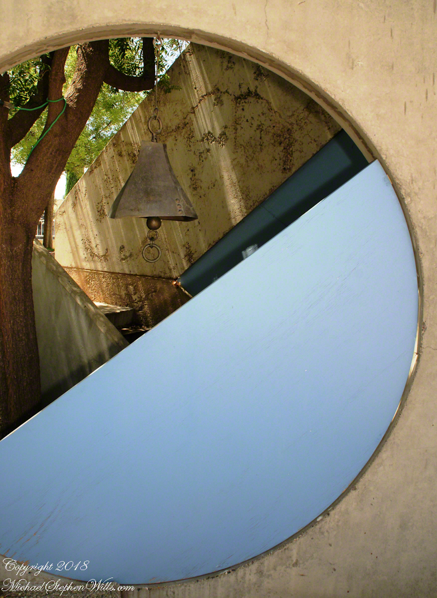
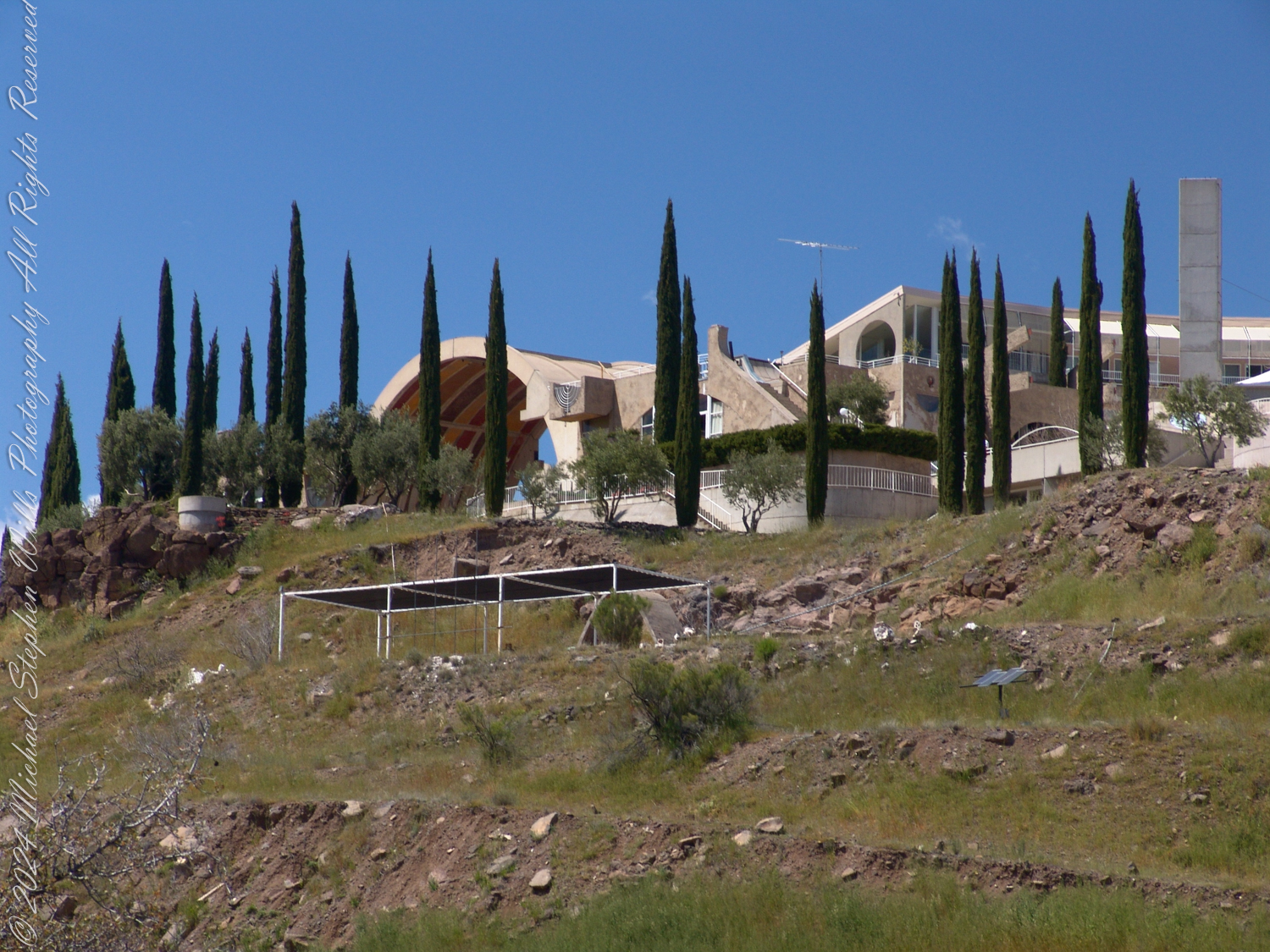
Walking further, I encountered an outdoor arch framing a bell, its heavy bronze form suspended against a panel of sky-blue. The simplicity was striking: a geometric dialogue between the natural and the constructed, a kind of meditative pause within the bustle of ideas. I lingered, allowing my thoughts to settle as the bell swayed gently in the wind.
Bell and Panel from the Colly Soleri Amphitheater
Bell Casting was and continues to be a major source of income.
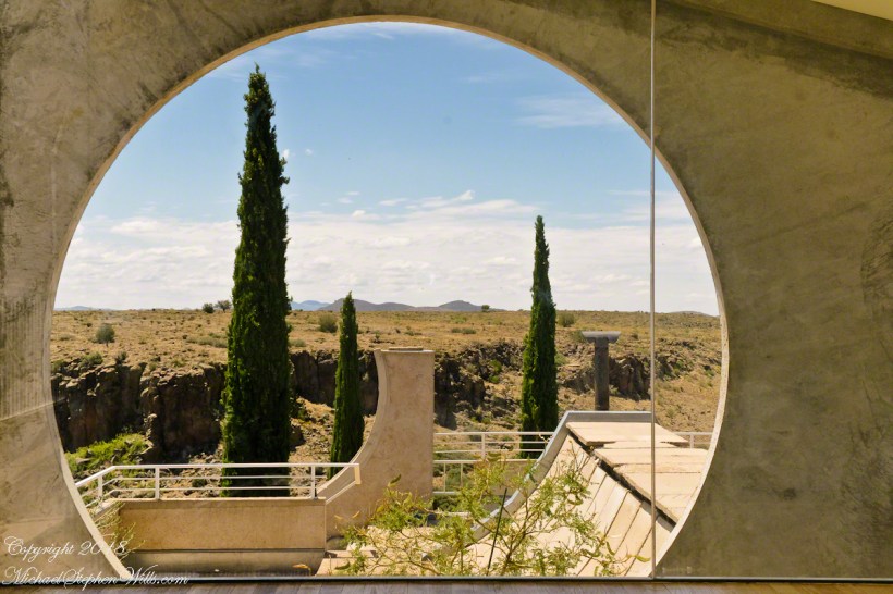
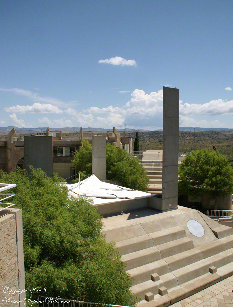
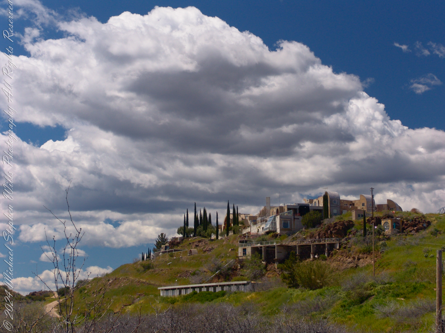
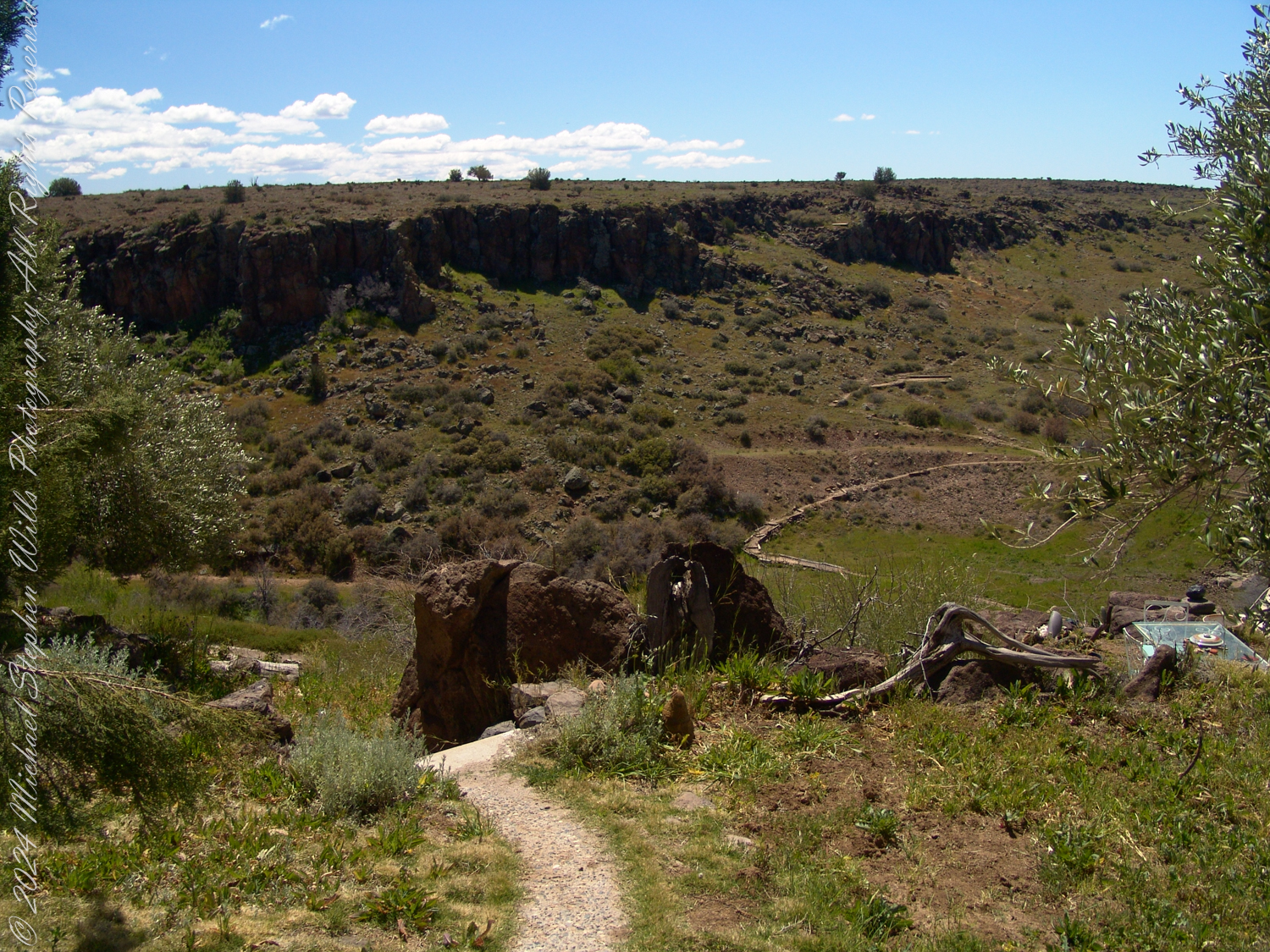
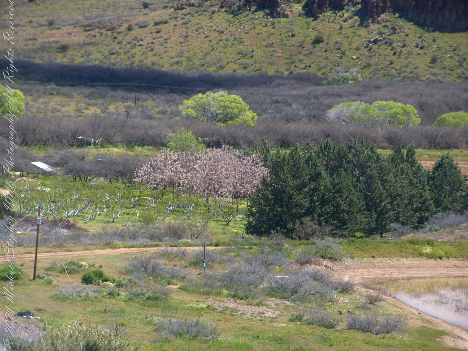
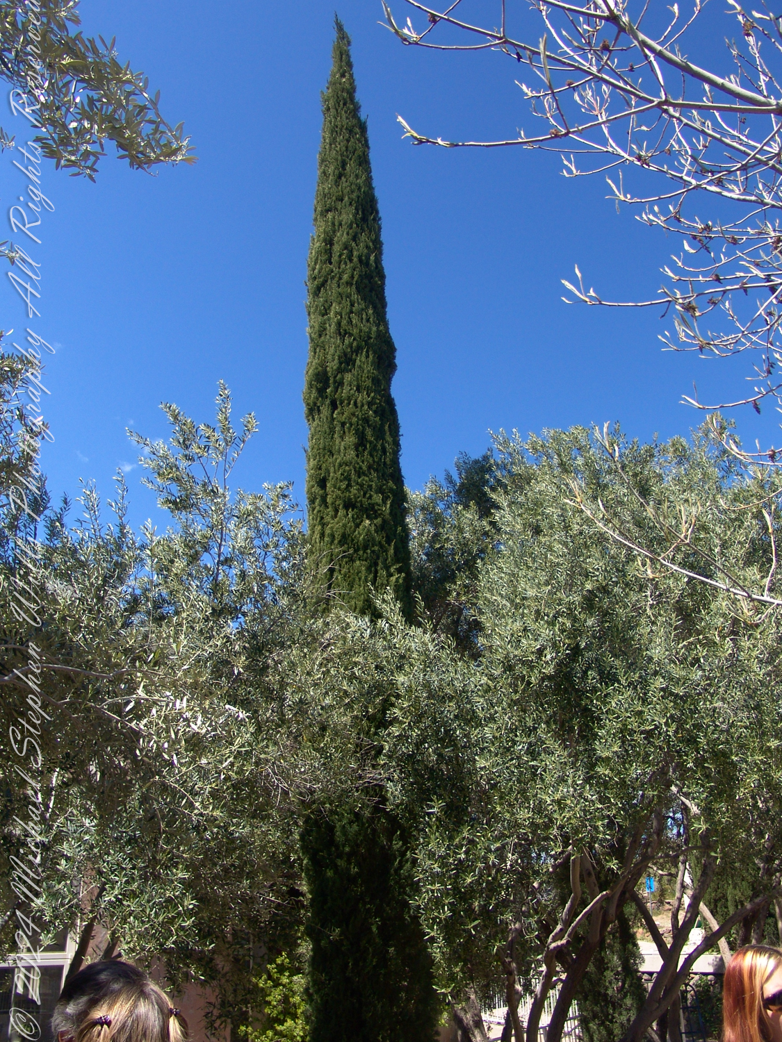
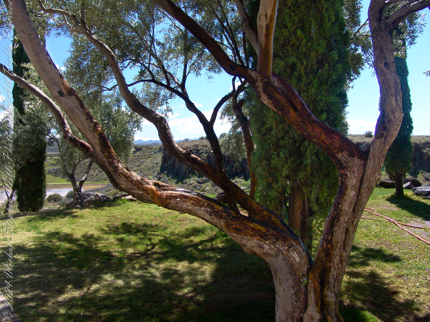
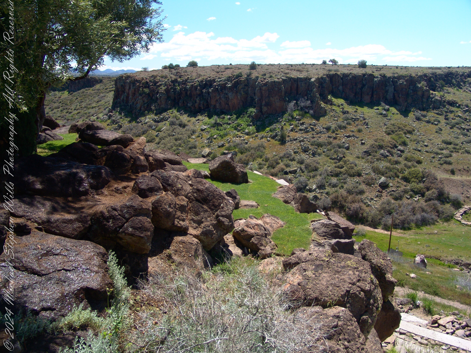
Each turn at Arcosanti revealed yet another viewpoint, another carefully composed alignment of architecture and nature. The sweeping views of the Arizona desert, framed by bold circular cutouts, were a reminder of our smallness in the grand scheme of things. The cypress trees standing tall against the rugged cliffs offered a contrast of textures—natural and man-made—that felt uniquely Solerian. His vision was alive in every corner: the terraces, the staircases, the unassuming balance between the earth’s rawness and humanity’s imagination.
View from the East Housing complex to the East Across Arcosanti
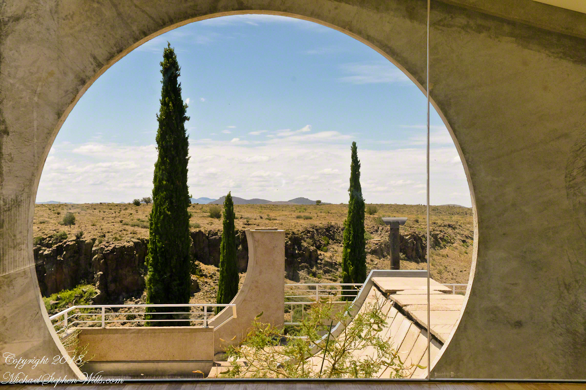
As I stood gazing through one of the monumental circular frames at the horizon, I reflected on how Soleri’s ideas, abstract in the present, are also tangible, concrete, and inspiring—literally and figuratively. Despite his passing, the project he began decades ago continues to evolve, a living experiment in how we might reimagine our relationship with the planet.
View to the South with Cypress Trees from a Portal of the Crafts III Building
The journey to Arcosanti is a physical one and a rediscovery of ideals. Soleri’s Arcology—a fusion of architecture and ecology—reminded me of our potential to create something not only functional but also deeply meaningful. Here, amidst the Arizona desert, was proof of a life’s work that still speaks to humanity’s potential for coexistence and creativity.
As I prepared to leave, the weight of Soleri’s vision stayed with me, much like that lecture hall memory from all those years ago. The sun was setting, casting long shadows across the concrete forms. Arcosanti stood resolute, a tribute to one man’s dream and a reminder to all of us: change is not instantaneous, but with patience, vision, and humanity, it is possible.
Enter your email to receive notification of future postings. I will not sell or share your email address.
Copyright 2024 All Rights Reserved Michael Stephen Wills
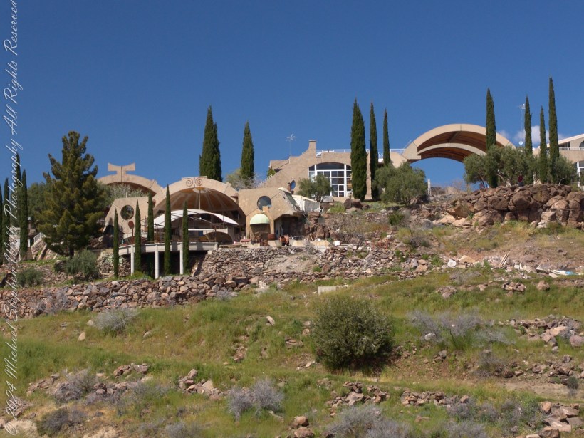
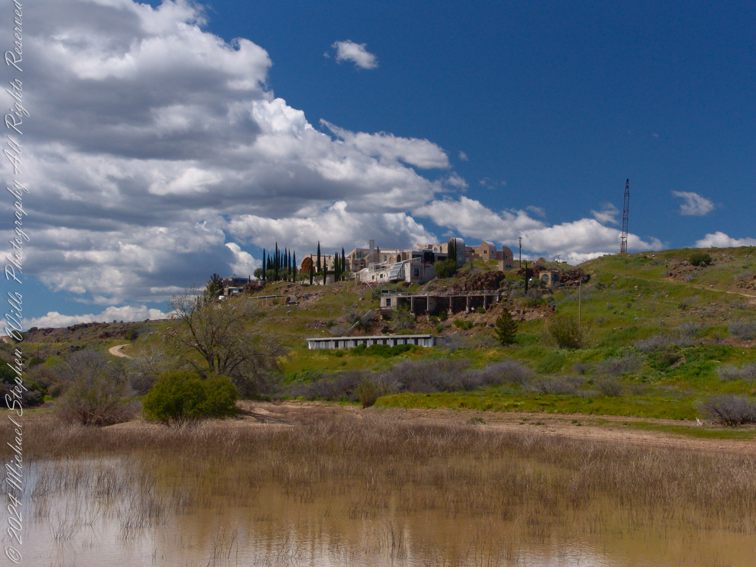
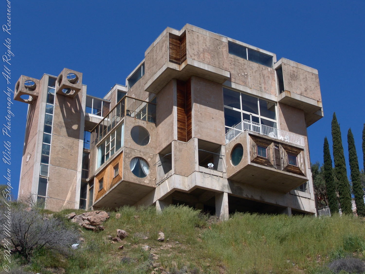
Approaching Arcosanti from afar, a cluster of forms rising from the Arizona desert like a mirage of human imagination. Against the cobalt sky, the buildings seemed to breathe with the land itself, their curves and edges echoing the undulations of the hillside. From this distance, the structures were both distant dream and solid reality, their symmetry a whispered promise of order amidst the chaos of the wild.
As I moved closer, the buildings revealed their intricate secrets. Circular windows stared like unblinking eyes, portals to a world shaped by creativity and purpose. Towers and cubes jutted confidently into space, their bold geometry softened by the earthen hues of concrete and weathered wood. These materials, neither foreign nor intrusive, seemed born of the very soil beneath my feet. There was an undeniable rhythm to the place—a harmony where art, function, and the timeless desert converged.
I walked among the structures, their forms towering above me like sentinels of some ancient philosophy reborn for a modern age. The elevated walkways beckoned with a quiet invitation, connecting one sanctuary of thought to another. Circular motifs repeated like a mantra, reminding me of the cycles of life, of the sun and the moon, of the unbroken circles that hold us together. Here, design was not merely a tool but a hymn, sung in concrete and glass.
Then, I turned my gaze outward, to the land that cradled this creation. The desert was alive, though its voice was quiet and deliberate. Rocks, worn smooth by the patient hand of time, rested among tufts of sage and grasses that swayed in the breeze. The light played its own game, casting shadows that danced across the ground, a choreography as old as the sun. Paths meandered through this terrain, their curves a gentle suggestion rather than a command, inviting me to wander but not to conquer.
Arcosanti
The trees stood tall and still, their presence both steadfast and serene. The cypress trees, their slender forms reaching toward heaven, seemed like exclamation points on the landscape, their verdant green cutting through the sky’s azure expanse. Beside them, olive trees spread their silvered arms, their gnarled trunks telling stories of endurance and quiet strength. One cypress, in particular, caught my attention—so perfectly straight, so impossibly regal, as if it had been planted by the hand of a god.
Beneath the olive trees, I paused, tracing my fingers along the bark’s intricate patterns. The sunlight filtered through the leaves in golden shards, dappling the earth beneath with shifting shapes. The air carried the scent of something ancient and vital—a blend of dry earth, sun-warmed bark, and the faintest hint of blooming life. It was a reminder that even in this place of human creation, nature reigned supreme.
I wandered to the edge of a canyon, its rugged walls carved by time’s relentless flow. The raw power of the landscape stretched out before me, a tapestry of stone and shadow that humbled and awed. Here, the boundaries between human vision and natural grandeur blurred. The olive and cypress trees, so carefully placed, seemed less an intrusion and more a part of the desert’s rhythm. They were a bridge, a whispered conversation between what is made and what simply is.
Finally, the paths called me back, their winding lines leading me deeper into reflection. Each step felt deliberate, as though I were tracing the lines of a poem etched into the earth. The trails curved gently, like the desert’s own breath, and I followed, not as an intruder but as a guest. The buildings now stood behind me, a testament to the balance we strive for—between the ephemeral dreams we build and the eternal landscape that cradles them.
This place is a meeting of stone and sky, a meditation: reminding us that, if we listen, the land will teach us how to live in harmony. Here, in the desert’s embrace, I found space to ask better questions, my heart as open and unbroken as the endless horizon before me.
Enter your email to receive notification of future postings. I will not sell or share your email address.
Copyright 2024 All Rights Reserved Michael Stephen Wills
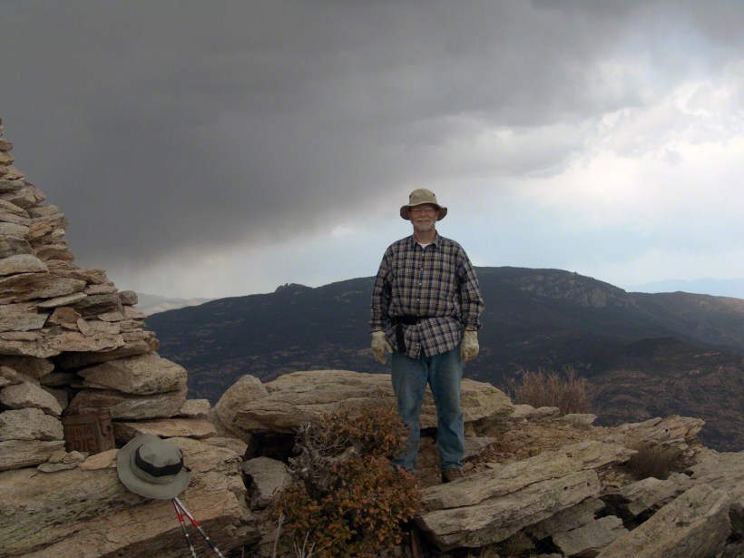
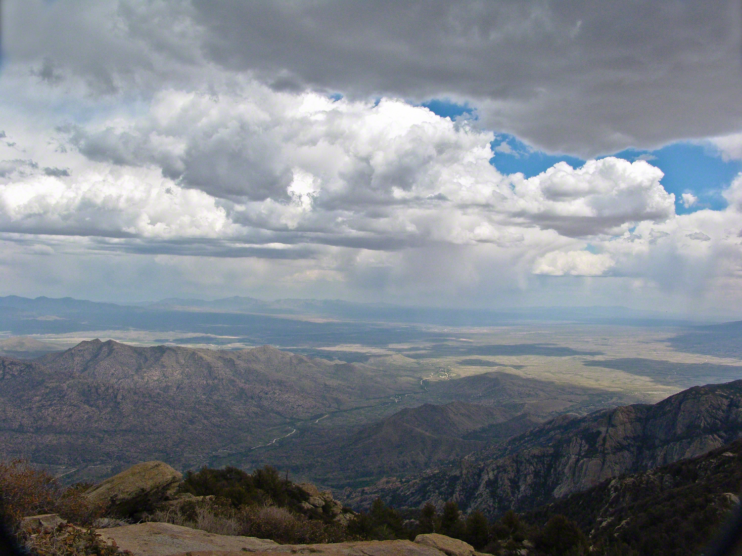
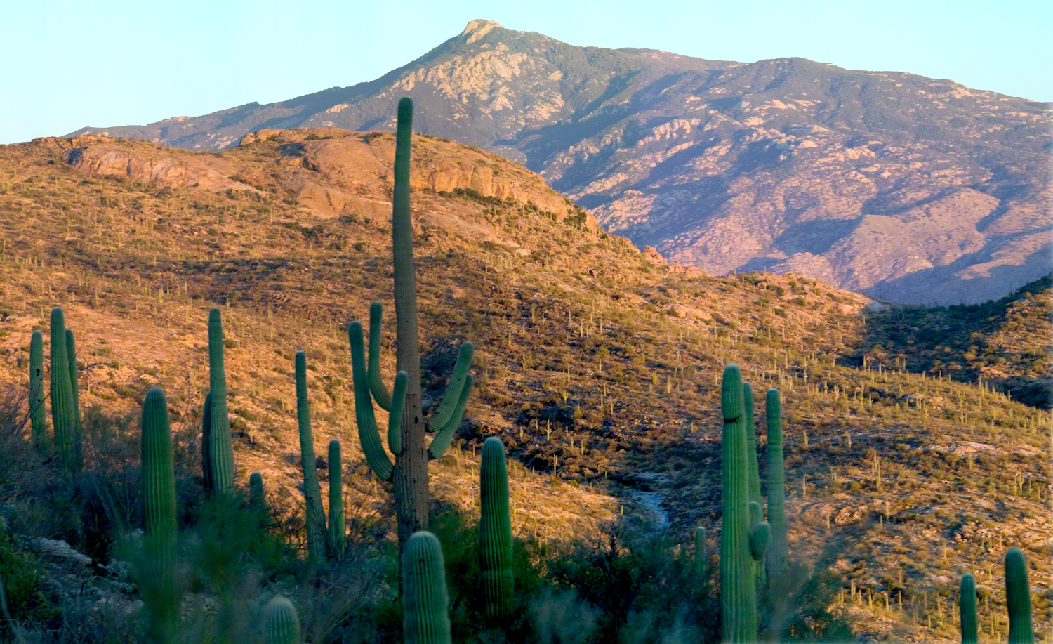
As we stood atop Rincon Peak, the sky darkened with the approach of a sudden thunderstorm. Below us, the San Pedro River valley sprawled, with the Mae West Peaks to the left and the legendary Dragoon Mountains straight ahead. This photograph captures that exhilarating moment—standing on the summit with the world at our feet and the wild Arizona sky closing in. Curious about how we got there and our race against nature’s fury? Join me on the blog to delve into the full adventure and explore more stunning images from the heart of the Rincon Wilderness.
The Rincons are one of 42 Sky Island mountains isolated from each other due to gradual warming and drying climate changes since the last ice age, 10,000 years ago. While this marvelous environment of oak and pine forests is accessible only on foot and with significant effort, it is visible from every point of the Tucson valley, home to a million inhabitants.
The name ‘Rincon,’ Spanish for ‘corner,’ reflects the mountains’ shape as they enclose a space on the west and northwest. This area, formerly used for ranching, is now being developed for tract housing. In contrast, the mountains themselves are preserved as wilderness, with parts designated within the Saguaro National Park and the Coronado National Forest.
In the past 51 years, I have been lucky enough to visit the Rincon Wilderness interior four times, shouldering different style backpacks onto the mountain and walking in different boots. My first trip was during college in the 1970s, when a party of six of us left from the end of Speedway, heading up the Douglas Springs trail. The climb was an exercise in desert survival that several friendships did not survive, replaced by new friends met on Mica Mountain. I have no photographs from that experience, only memories and the backpack.
Decades later, reconnecting with Arizona in 2004—thirty-one years after that first experience—I took no chances. This time, my attempt on Rincon Peak was a success. I reduced risk and effort, though not eliminating them, by hiring a guide for the four-day trip. We reached Rincon Peak via the Turkey Creek Trail out of Happy Valley, climbing a mountain buttress with views that widened and lengthened with every step.
Capturing these moments, I took several photographs during that experience. Two years later I added a landscape of the peak at sunset.
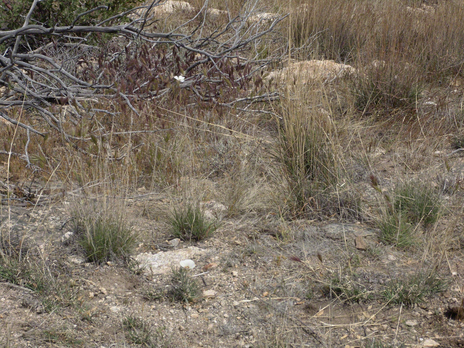
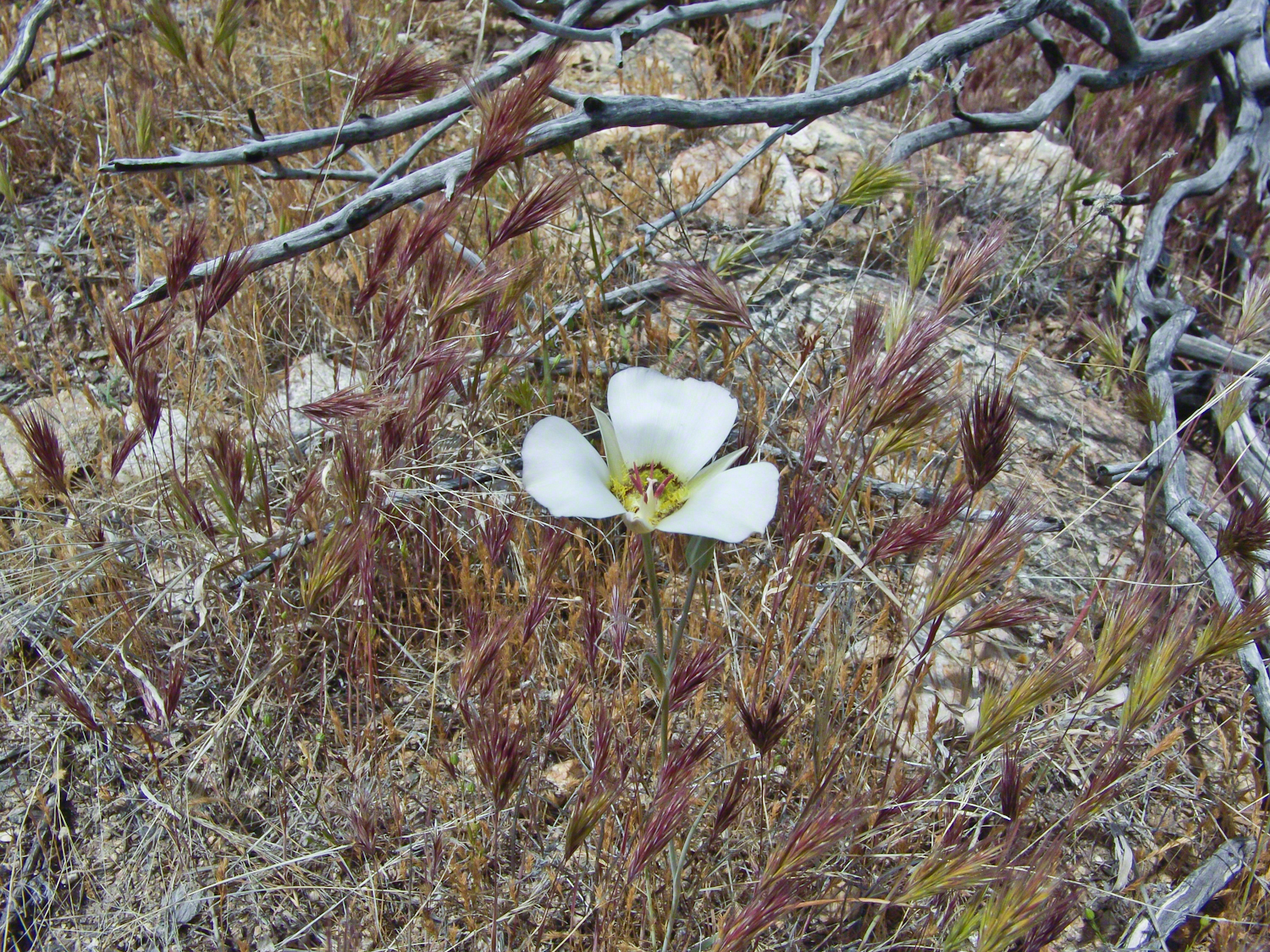
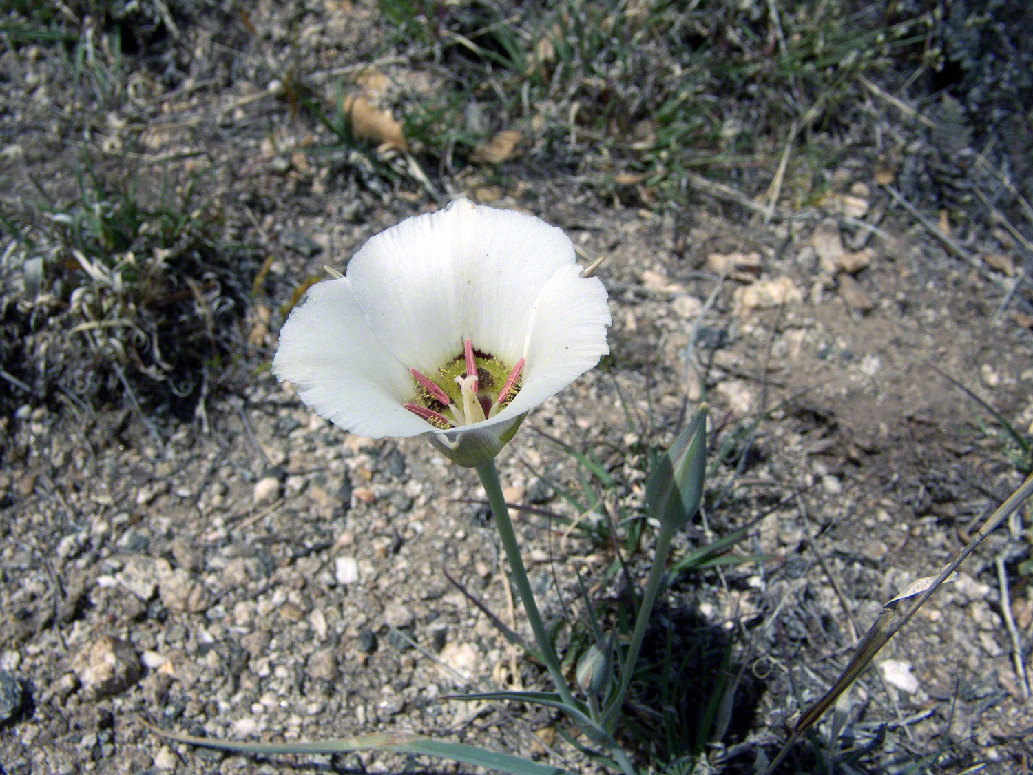
Along the Turkey Creek trail, Sego Lilies bloomed among a stricken oak and drying grasses, offering a vivid glimpse into the region’s delicate ecosystem. It is the winter rains that trigger such a bloom.
Enthralled by their beauty, we paused while I unpacked my gear to photograph the Sego Lilies growing along the trail.
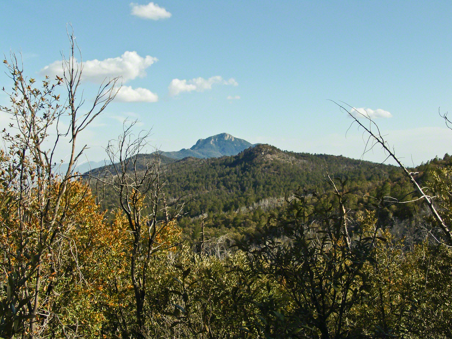
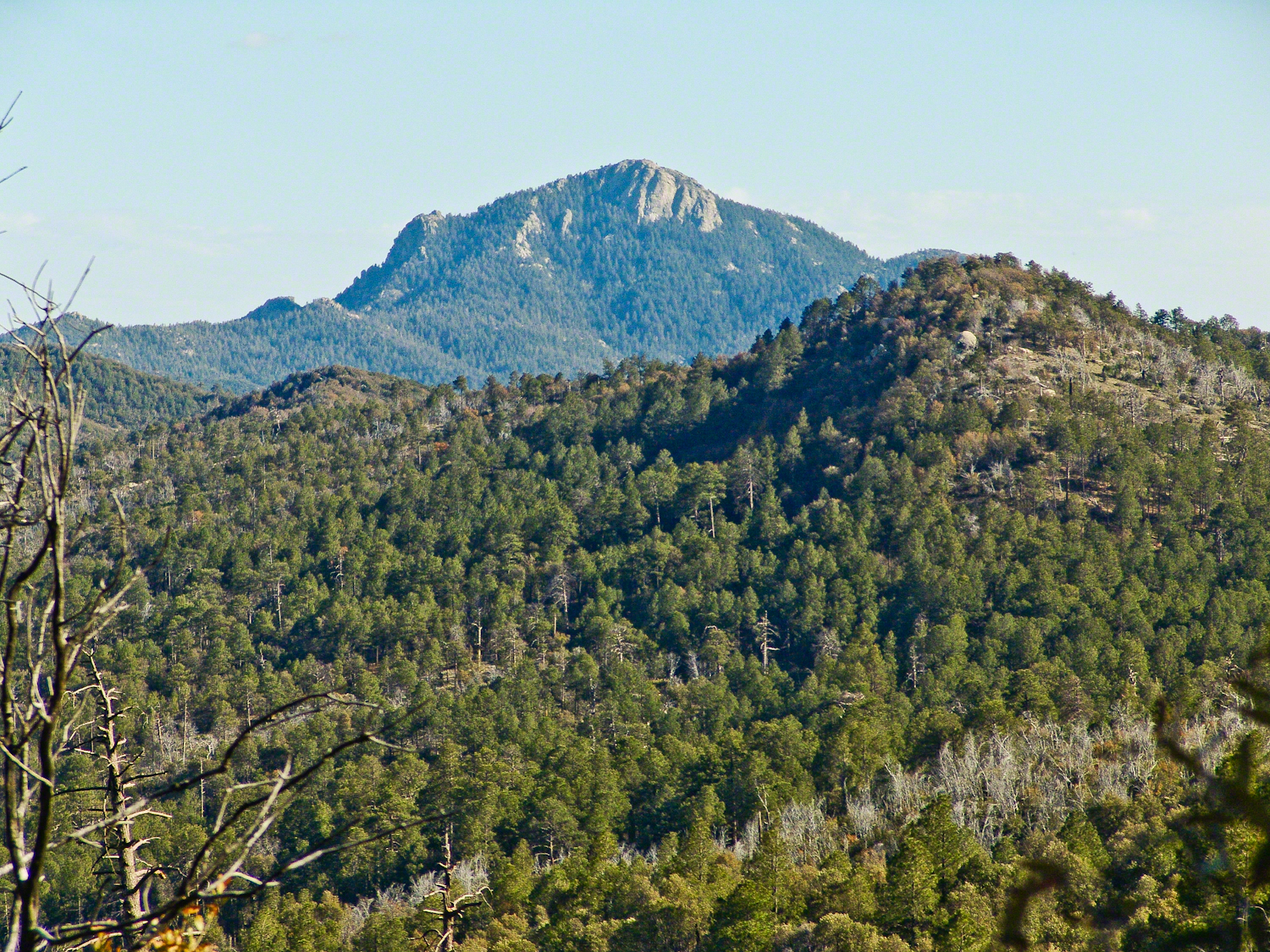
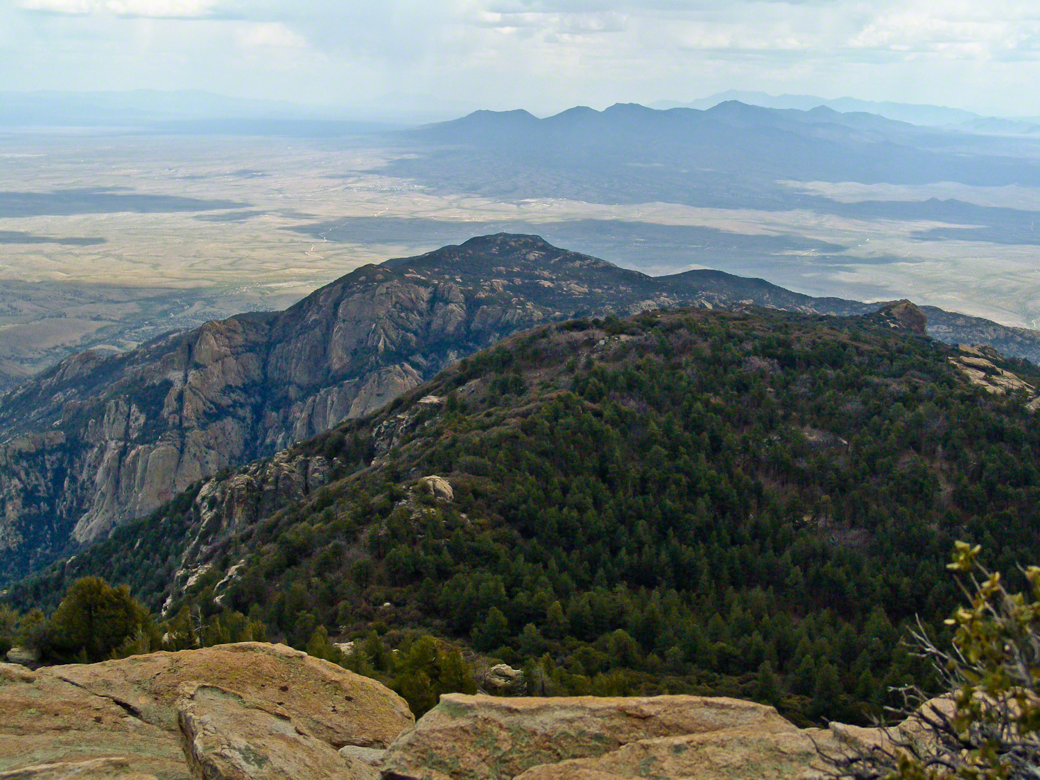
When we reached Deer Head Spring at the top of Turkey Creek Trail on April 27, 2004, it was a moist spot with no accessible water. With only about a gallon of water each remaining, we pressed ahead to Heartbreak Ridge and climbed into Happy Valley Saddle, where, thankfully, the creek—though low and full of algae—was usable. It was here that I caught my first glimpses of Rincon Peak, looking across the aptly named Heartbreak Ridge and Happy Valley Saddle.
From Rincon Peak, the view to the south was breathtaking. The white rocks at the lower right formed the Valley of the Moon wall. Below lay the San Pedro River valley, with the Mae West Peaks at the left margin and the Dragoon Mountains with Cochise Stronghold at the center. I took this photograph around 12:30 PM on April 28, 2004, just as a thunderstorm was approaching.
Rotating the camera to the south-southwest, the view stretched over the Valley of the Moon to the eastern Tucson Valley and the Sky Islands of the Whetstone Mountains (Apache Peak), with the Santa Ritas behind them. In this vast landscape, the works of man are overpowered by sky, rock, and distance.
We made a hasty departure ahead of the thunderstorm. Attempting the peak that day had been a touch-and-go decision, but we reached the summit with moments to spare.
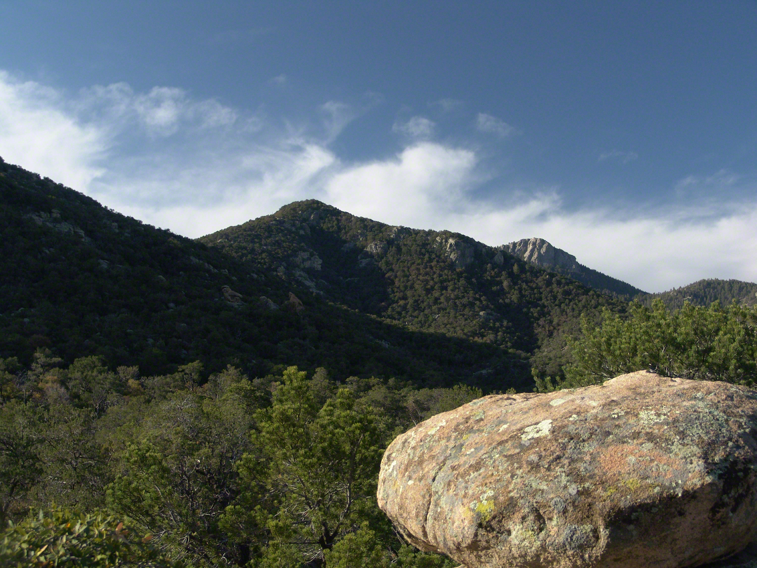
On the morning of April 29, 2004, the day after reaching Rincon Peak, I set up my tripod near our Happy Valley Saddle camp. In the serene early morning sunlight, I captured images of Rincon Peak, reflecting on the previous day’s ascent.
On the day we descended to the X9 Ranch via the Rincon Creek trail, we were granted a unique opportunity. My guide’s grandfather had a homestead at the X9, and his access to the trailhead through private lands opened this ro ute for us. That evening, I took a photograph of the sunset on Rincon Peak from the X9 Ranch, looking east from the ‘Rincon’—the corner formed by the massifs of Rincon Peak, Mica Mountain, and Tanque Verde Ridge.
The X9 ranch sits in the Rincon (spanish for corner) made by the massifs Rincon Peak, Mica Mountain and Tanque Verde ridge.
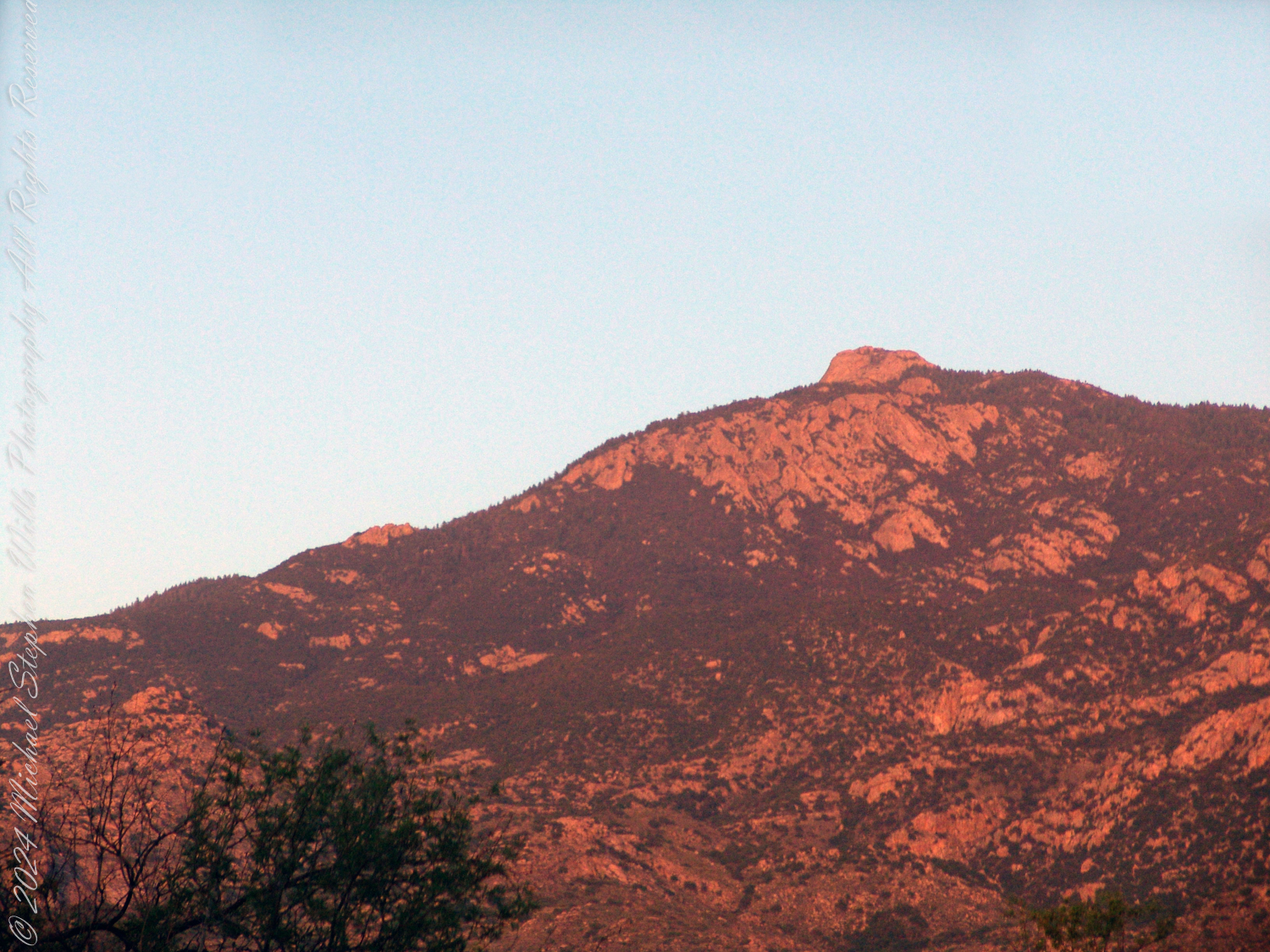
Two years later, on the evening of November 2, 2006, I climbed the Tanque Verde trail in Saguaro National Park East for about 30 minutes to reach a vantage point of Rincon Peak. Intending to capture the peak bathed in golden light, I waited until just before the sun set behind the Tucson Mountain. Afterwards, I raced the sun hiked back to the car. In my hurry, I tripped on a stepped turn and dove headfirst into a large prickly pear cactus. It was a very painful experience. Large spines pierced my face, while tiny, pesky spines covered my chest and back. The large spines, not being barbed, came out easily, but I needed to visit a physician to remove the rest.
Antelope Canyon, a sacred space in the Navajo Nation, reveals the dance of light and sand within its ancient walls. The interplay of erosion and transformation highlights beauty in impermanence, emphasizing patience and reverence for nature’s ever-changing essence.
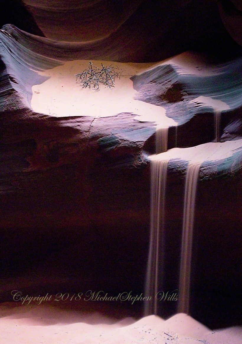
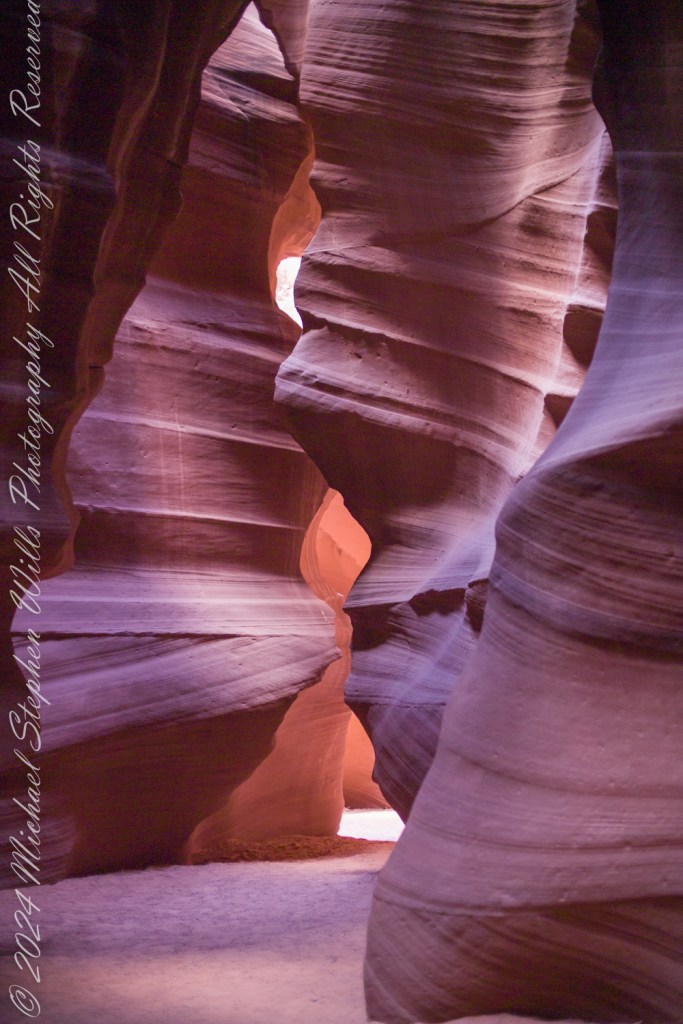
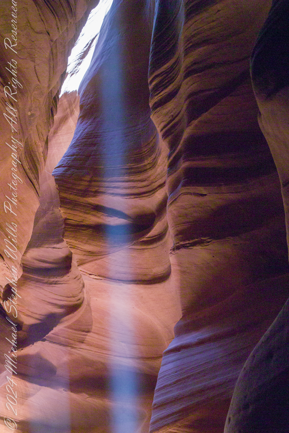
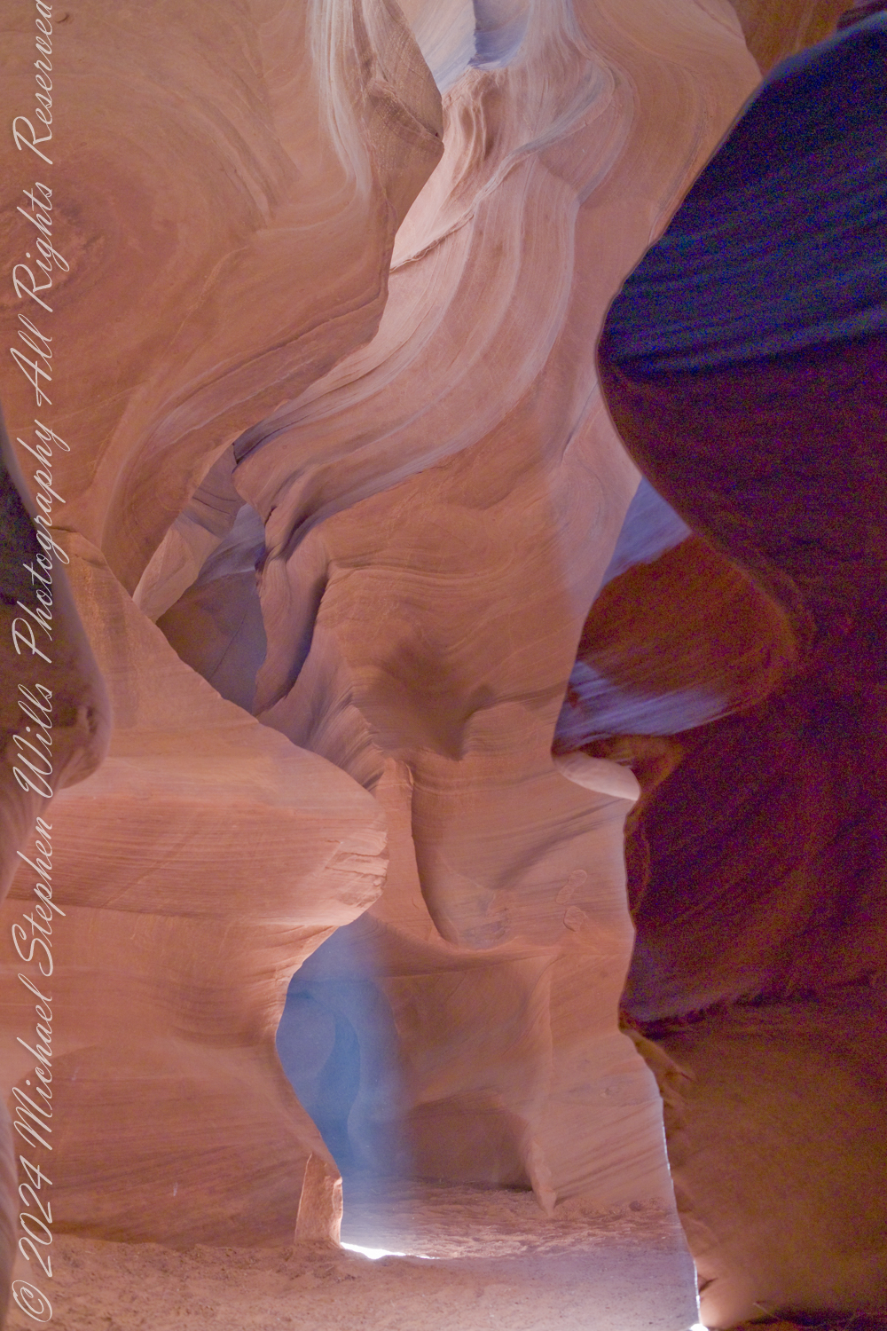
Enveloped by shadows and light in the stillness of Antelope Canyon the air carries silence—vast and ancient—interrupted only by the whispers of grains shifting under unseen currents. Here the red rock of the northwestern corner of the Navajo Nation was pulverized into sand by the action of wind, water, sun, and cold. The walls, carved by patient time, cradle the moment as if holding a sacred breath.
Antelope Canyon is in the Navajo Nation near Page, Coconino County, Arizona
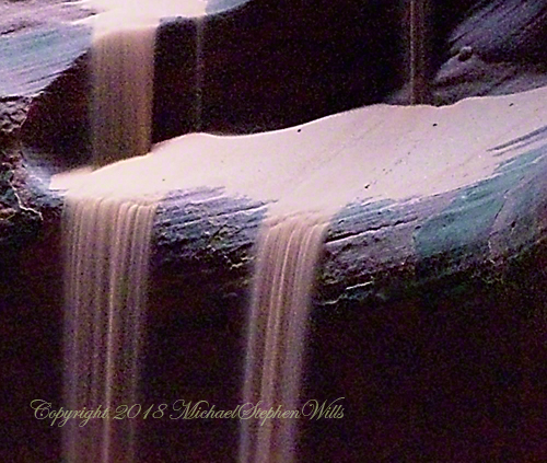
Antelope Canyon, timeless and transient, has summoned me to witness something unique—a dance between light and matter. The delicate, insistent sand flows like water from a carved bench, shaping the scene with quiet power. It tumbles as if alive, forming ephemeral cascades, revealing that erosion is not destruction but transformation. Each grain a story—a fragment of the ages, polished smooth by untold moments of pressure and release.
A Slot of Shadows and Light
I wait in the dry darkness of upper Antelope Canyon for the perfect moment to capture the spirit of the place. Light penetrates the narrow slot above, a thin beam spilling through the crevice, drawn by something deep below. In this confined space, sunlight becomes an entity. It touches the red sand and animates the space, revealing stone textures and the fleeting movement of sand in freefall.
Antelope Canyon is in the Navajo Nation near Page, Coconino County, Arizona
The play between dark and light reminds me that beauty often lies in contrast. The polished walls that surround me were once jagged, raw stone. They have become smooth under nature’s relentless touch—proof that endurance shapes elegance. The canyon’s walls, though fixed in place, seem to sigh as the sand slips over them, embodying a paradox of permanence and impermanence.
An Elemental Meditation
I am a visitor as well as part of a conversation held in languages older than words—spoken by rock, sand, shadow, and light. I sense the ancient stories etched into the stone and carried within each grain that spills like an hourglass. Here, nothing is wasted; everything contributes to a continuous process of becoming. The sand, which once formed the walls, now shapes the canyon floor, each element recycling into the next chapter of this landscape’s life.
Antelope Canyon is in the Navajo Nation near Page, Coconino County, Arizona
The act of waiting for a right moment teaches me that patience is both passive and an active engagement with time. I am reminded that what I witness will never be exactly the same again. Even though the canyon may stand for millennia, each second contains a uniqueness. The sand cascading before my eyes will settle, be disturbed, and flow again—but never in quite the same way.
Capturing the Spirit of Place
I set the camera on a rented tripod, knowing photography is an imperfect attempt to hold onto what cannot be possessed. This place does not belong to me—it belongs to itself, shaped by forces far greater than any human hand. My role is not to own the scene but to honor it, to acknowledge its fleeting magnificence by framing a moment within the lens.
The shutter clicks, the cascade of sand becomes immortalized held in that instant. Yet I know that the photograph, while capturing the image, will not fully encompass the spirit of what I have experienced. This place is a meditation, a reminder that life itself flows in ways we cannot control. Like the red sand, we are carried by forces—sometimes gentle, sometimes fierce—shaping and reshaping us through time.
As I gaze at the sand, a quiet sense of reverence flows through me. This moment, like the grains tumbling in front of me, is already slipping into the past. But in its passing, it leaves behind something intangible yet enduring—a memory of beauty found not in permanence but in change.
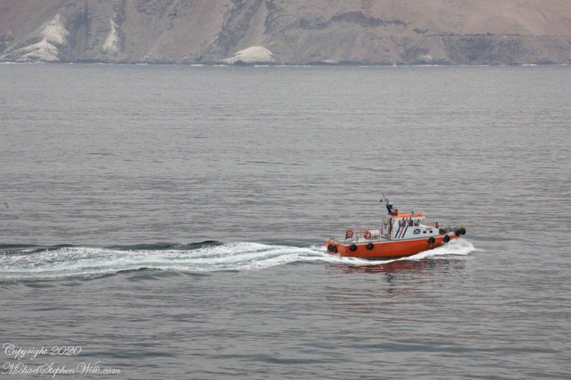
Discover the vibrant blend of history and modern maritime traditions in Iquique. From the dramatic escarpment backdrop to the bustling harbor, join us on a journey exploring the city’s past and present, anchored in seafaring tales.
Embark on a journey through the serene Rincon Mountain Wilderness with me. Witness the rugged beauty of the Hedgehog Cactus and the whispering Bear Grass through my lens. Let’s unravel the secrets of the desert together, and find solace in the still life of the Happy Valley Saddle. Join me, and let’s capture the enduring spirit of Arizona’s hidden treasures.