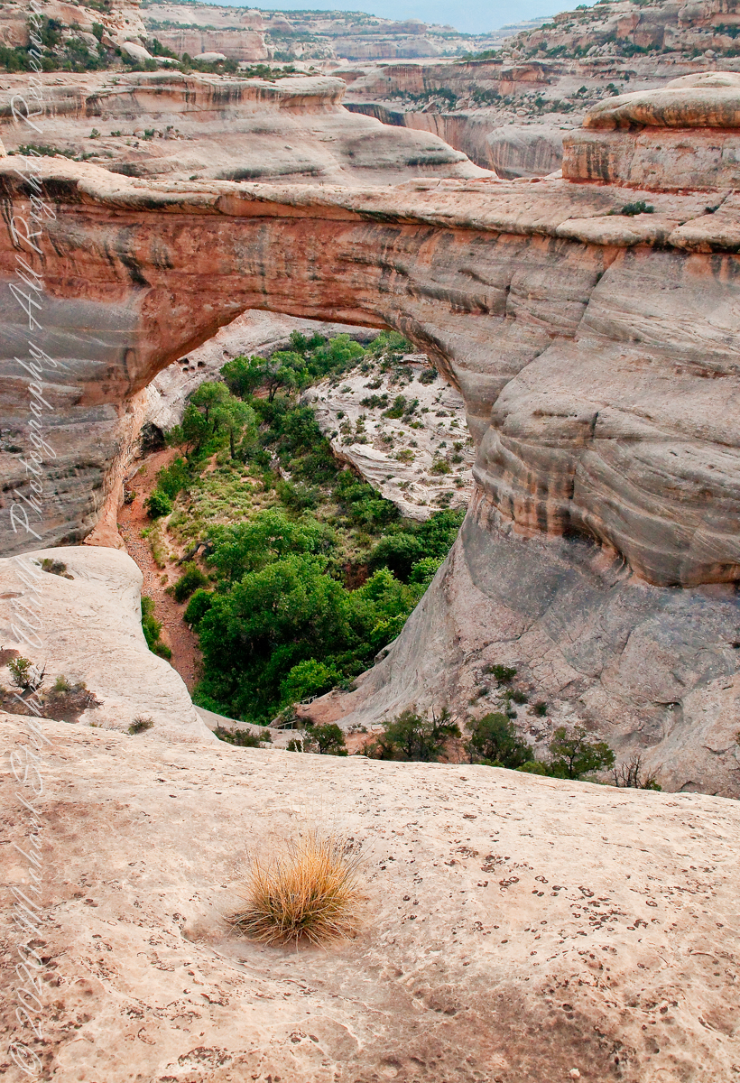
Sipapu is one of the largest natural bridges known.
Part of the Natural Bridges National Monument in Utah, a place inaccessible until the “uranium boom” of the 1950’s and the road was only paved in 1976.
We visited on a July day of thunderstorms, which you see building here. If you look closely at the base of the bridge, you can see the railings my wife and I used to climbed the steep sides of White Canyon.
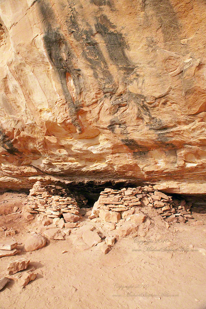
We hiked a few miles along an unmaintained trail. On the way we passed ancient cliff dwellings. The area is a maze of canyons throughout which these ruins are scattered.
Sipapu is a Hopi word for the small hole or indentation in the floor of kivas used by the Ancient Pueblo Peoples and modern-day Puebloans. It symbolizes the portal through which their ancient ancestors first emerged to enter the present world.
A natural bridge is formed through erosion by water flowing in the stream bed of the canyon.
Sipapu Bridge is 268 feet across and, standing in the stream bed, it is 220 feet above your head. That is white Permian sandstone, after which White Canyon is named.
Copyright 2023 Michael Stephen Wills All Rights Reserved
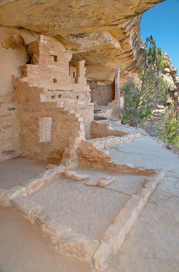
This group of buildings was crafted into a cliff face over 1,000 years ago.
Visitors must climb over the cliff and through narrow tunnels, security features created by the builders.
High Security and Adventure
Security barriers include a 32 foot, entrance ladder made from pine trunks and a narrow squeeze through a 12 foot tunnel.
My photograph of Balcony House features ruins to rooms on a plaza. Also shown are edges of two kivas (circular ceremonial chambers) built into the plaza floor. I am standing in a plaza, next to the cliff.
Behind me (not visible) is the narrow security tunnel used by the ancient builds to control access. Today, visitors crawl through the narrow tunnel to exit the site. There are 40 rooms in Balcony House.
Copyright 2023 Michael Stephen Wills All Rights Reserved
“From the fire tower on Bear Swamp Hill, in Washington Township, Burlington County, New Jersey, the view usually extends about twelve miles. To the north, forest land reaches to the horizon. The trees are mainly oaks and pines, and the pine predominate. Occasionally, there are long, dark, serrated stands of Atlantic white cedars, so tall and so closely set that they seem spread against the sky on the ridges of hills, when in fact they grow along streams that flow through the forest. To the east, the view is similar, and few people who are not native to the region can discern essential differences from the high cabin of the fire tower, even though one difference is that huge areas out in this direction are covered with dwarf forests, where a man can stand among the trees and see for miles over their uppermost branches. To the south, the view is twice broken slightly — by a lake and by a cranberry bog — both otherwise it, too, goes to the horizon in forest. To the west, pines, oaks, and cedars continue all the way, and the western horizon includes the summit of another hill — Apple Pie Hill — and the outline of another fire tower, from which the view three hundred and sixty degrees around is virtually the same as the view from Bear Swamp Hill, where, in a moment’s sweeping glance, a person can see hundreds of square miles of wilderness. The picture of New Jersey that most people hold in their minds is so different from this one that, considered beside it, the Pine Barrens, as they are called, become as incongruous as they are beautiful.” From The New Yorker magazine, November 26, 1967, “Profiles, The Pine Barrens I” creative non-fiction by the great John McPhee.
This quote captures the contours of a place, now known as “The Pinelands,” a corner of Burlington County, New Jersey my English, Irish, Scottish ancestors settled from 1677 until my grandfather, James Edward Wills, left for northern New Jersey, Asbury Park, in the first years of the twentieth century. This past decade, more so since retirement 2017, I’ve explored these two hundred and twenty (220) or so years beginning with amorphous asides over the years from my father and second hand through my sisters then through online research via Ancestry.com (Ancestry) and other searches.
From my father and sisters I knew to search southern New Jersey. The United States decennial census, “thank you Constitution,” listed a George and Margaret Wills with my grandfather among their children. Great Grandfather George Wills was listed as a 14 year old child of George and Mary Wills in the 1850 census. How could I be sure? DNA technology with internet based social interaction helped there. I was contacted by a Dellett descendant, identified by DNA as a fourth cousin, who claimed Mary Wills as a double great aunt, the daughter of James and Ann Dellett. Here is a screen capture of an Ancestry “ThruLines” analysis showing the six living ancestors of James and Ann in the database. I removed the names and photos of the other five to preserve privacy. The DNA fourth cousin relationship was an exact match to the family tree.
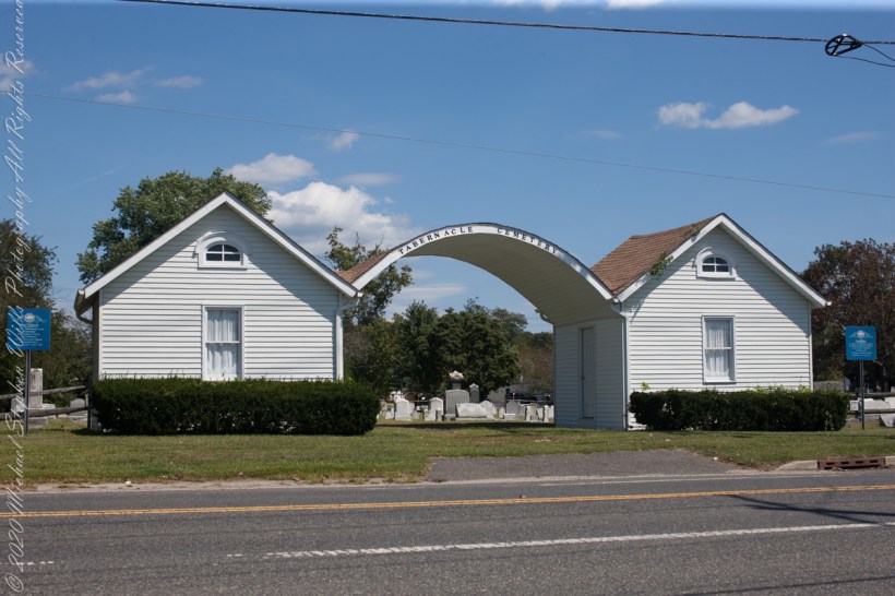
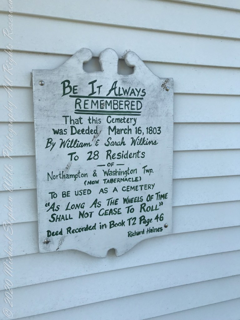
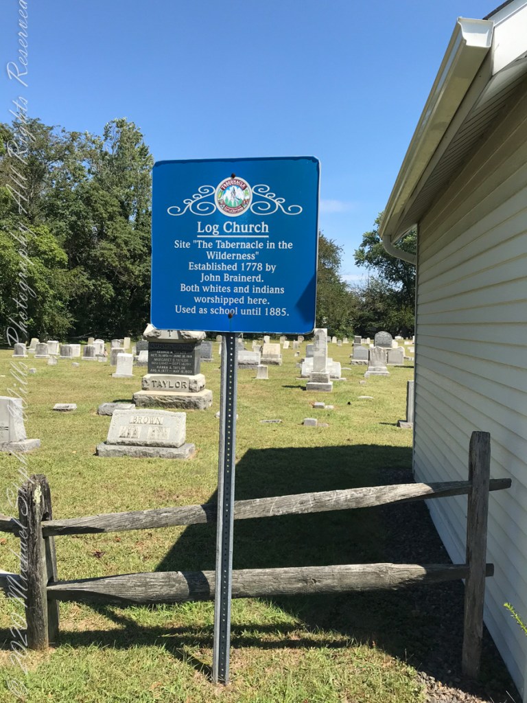
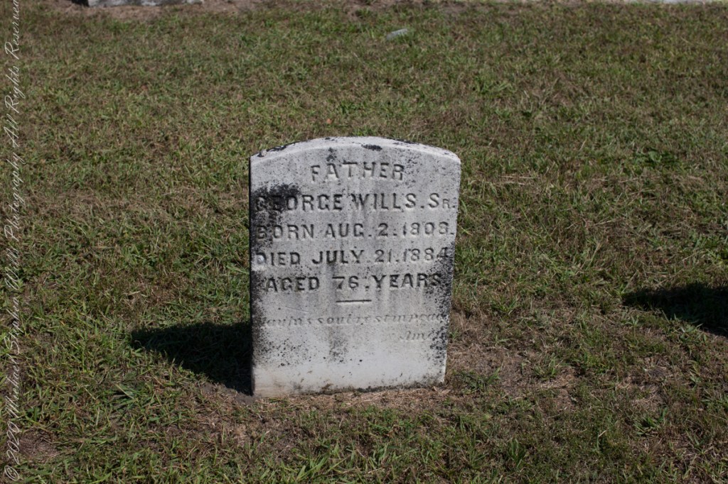
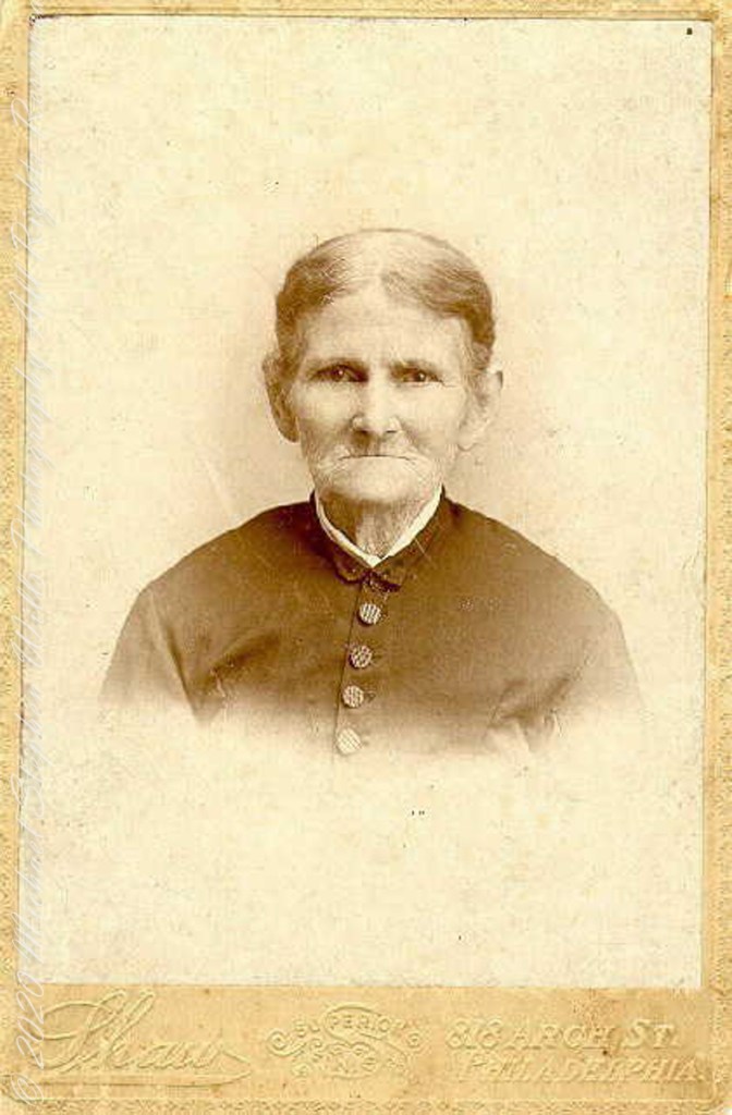
Cousin Delette provided antique photographs of George and Mary. I did a “FindAGrave” search, their final resting place is in a place named Tabernacle, Burlington County, New Jersey. September 2019 my wife Pam and I did a weekend tour with a bed and breakfast base in the city of Burlington, New Jersey. The rest of the photos in the following slideshow are from that weekend.
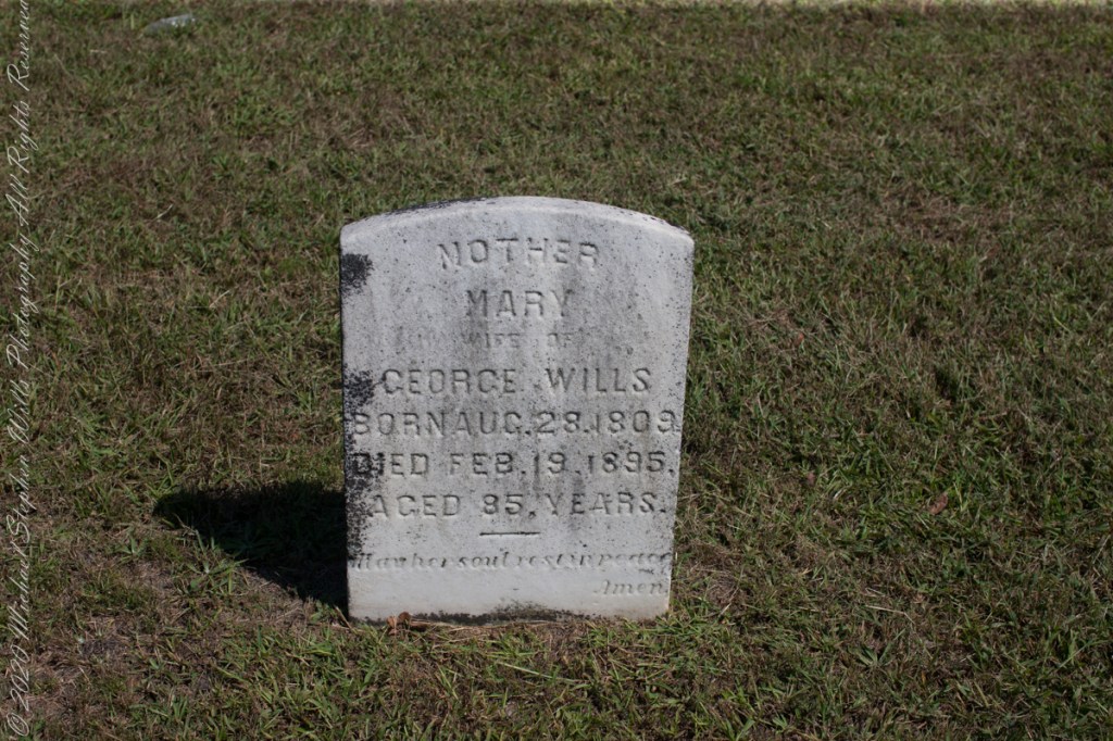
Resting place of double great Grandparents George and Mary WillsWooden Plaque on left sdie of entry pavilion. Sign to left of pavilionGeorge Wills, Hotel Keeper, around 1850Father, George Wills, Sr., Born August 2, 1809, Died July 21, 1884 Aged 76 years., May his soul rest in peace, AmenMary Dellett Wills, as widow after 1894Mother Mary wife of George Wills, Born August 28, 1809, Died February 18, 1895 Aged 85 years. May her soul rest in peace, Amen
Here is the same Ancestry “ThruLines” analysis with the immediate family links exploded. through my “first cousin 1 time removed” I was able to communicate with a “lost” niece of my father who shared reminiscences of him from the time he was just released from World War II Naval Service, before meeting Mom.
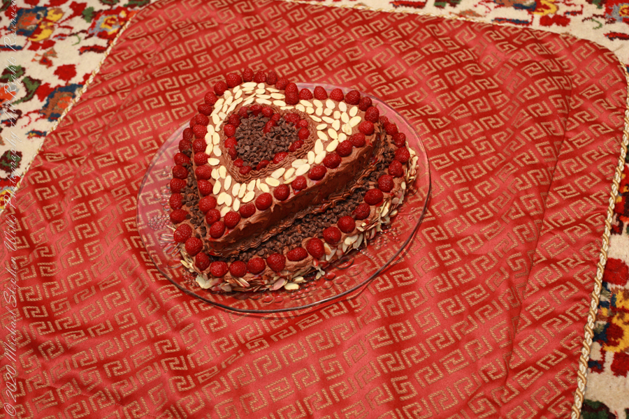
Theresa (2), Michael (5), Christine (4) in the livingroom of 107 Deepdale Parkway, Albertson, New York on Valentines Day 1959Chocolate Valentines Day cake by Pamela WillsPam and I aboard the Oceania Regatta sailing the Pacific Ocean off Chile. The following day we reached Puerto Montt.
Copyright 2025 Michael Stephen Wills All Rights Reserved
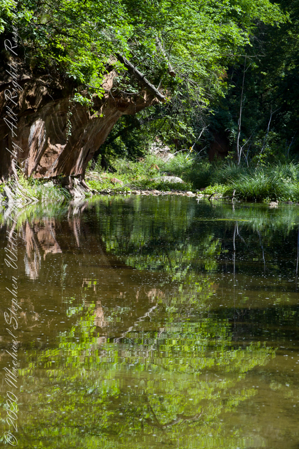
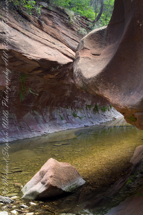
The fault of Oak Creek changes direction, here it forms a north/south gallery through Schnebly Hill Formation red sandstone for which Sedona is famous.
West Fork (108) Trail, Sedona, Yavapai County, Arizona
“Hello” from Oak Creek Canyon, “Photo by Pam Wills”
Gratitude for miracles witnessed is my emotion for this series, “Frozen Fall Creek.” Fifteen winters after Pam and I walked Fall Creek as a solid walking path, the stream flows without ice most years. My son, whose family now lives in the house, and his wife recalling walking the creek a few years ago, not in the past few years.
Weather records support our recollections and observations: here is an analysis of Ithaca January temperatures. The years 2009 through 2019 show a warming trend in daily temperatures for both minimum and maximum.
Analysis
Excel I used to plot minimum and maximum temperatures (Fahrenheit) for the 31 days of each January for eleven years 2009 – 2019. Click on the images of this post for a larger version.
Click any image for a larger view.
Forecast
Pam and I moved to Ithaca 2011 and missed our Fall Creek winter walks, miss them even more now our weekend excursions are only memories. Here are January minimum/maximum average daily temperature projections from 2020 through 2044 based on the trend established from the 2009 through 2019 series. The trend is the solid color, projection the faded color.
Reading from the chart, if the current trend continues by January 2044 the average maximum daily temperature will be 47 degrees compared to 29 for 2009. In other words, the temperature never rose above freezing in the year 2009. By 2044 temperatures will be above freezing every day, on average, with daily minimums averaging 21 degrees.
From what I read, we can expect these warming trends to accerate within our lifetimes. My son named small mid-creek hummocks “islands” with numbers. Here is a view of his Second Island in late summer. What will Second Island be in 2044 late summer?
Late Summer 2018, second island
Memories
Reader of posts I and II of this series have commented about snow shadows. Here are the shadows produced from snow fallen on the vegetation of the last photograph: soft mounds to contrast with tree trunk shadows.
Winter 2009, second island
I prefer the composition of the following photograph. What do you think?
Play of winter shadows
A combination of contrasting shadow forms.
Low Winter Sun
Copyright 2023 All Rights Reserved Michael Stephen Wills
My last post, “Frozen Fall Creek I”, ended with macros of Ice Crystals on a bed of frost over creek ice within sight of our former home, a restored water mill. I continued on the ice, following the creek to this spot were the stream bed turns 90 degrees, changing from a southerly to a western flow.
Here I encountered an open course where constant water motion resisted freezing. A few frigid days later, the course had an amazing transformation.
Last To Freeze, Fall Creek
The transparent ice of the now frozen space retained the impression of movement, the surface rippled by current. In the following photograph, motionless ice crystals reveal the truth.
Ice Crystals on Water Frozen while Supercooled
In the intervening days, the constant motion resisted freezing while the water temperature dropped well past freezing to achieve a supercooled state. As the water temperature continued to drop, a fast transition from fluid to solid happened so quickly the movement of the water surface was preserved.
Ice Crystals on Water Frozen while Supercooled
Here is the matching “after” photograph to the “before” that started this post.
Channel of Water Frozen while Supercooled
Copyright 2023 All Rights Reserved Michael Stephen Wills
In November 2004, a visit to Canyon de Chelly with guide Hadley Tsosie revealed ancient petroglyphs and ruins, highlighting Navajo culture and the canyon’s unique beauty.
On November 3, 2004 my son, Sean, and I made our way to Chinle, Arizona on the Navajo Reservation at the mouth of Canyon de Chelly.
The next day, driving a rented 4 wheel drive, we arrived at the visitor center, at dawn, and there met Hadley Tsosie who worked as a guide. This is how you do it, if learning about the Canyon is your goal. It is possible to walk, unaccompanied, into the canyon to view the “White House” and this I highly recommend. Tourists can also drive around the rim to various overlooks. This is what most people do.
The canyon is still farmed and the tribe only allows visitors when accompanied by a guide. Only Diné (Navajo) are certified as guides. They know the rights of way and the preferences of the landowners.
We negotiated with Hadley to take us for half a day for our interest in petroglyphs and ruins. It is important to start early when the sun is low in the sky, when directly overhead the details of ruins and petroglyphs are washed out by the light. Catching the late afternoon/evening sun is also an approach that requires detailed knowledge of the route, taking into account the time of year.
Hadley was an excellent choice, though he was our only option on that day. He was fluent in Navajo beliefs, the lore of the canyon and generous in sharing what he knew.
Here is Hadley, approximately 6.2 miles into the canyon with the “Ledge Ruin” behind. We arrived at the junction just in time, before the sun was high enough to wash out the ruin. It is slow going into the canyon what with the deep sand and water that must be negotiated. Hadley did the driving and was expert. We passed other parties bogged down in the wet sand. I do not believe it was luck that kept us moving . We stopped many times to talk and admire the petroglyphs and pictographs.
Petroglyphs are symbols incised, or cut, into the surface (the name means petro, “rock”, glyph, “symbol”). In the desert climate of the southwestern USA a thin, dark pigment forms on rock surfaces of overhanging cliffs. The pigment forms from infrequent precipitation, in the form of water, flowing downward over the surface or even dew. The high heat of the desert drives a chemical reaction between water, clays, iron and manganese oxide to form a coating on the rock surface. The dark coating, called “desert varnish”, contrasts with the underlying rock. When it is scraped away a line forms. Many of the petroglyphs were of this form. Others were carved into the rock itself, more time consuming and durable. No one knows when the petroglyphs were made, they were always there are respected. People have inhabited Canyon de Chelly for over a thousand years. The word pictograph has a different meaning when used to describe prehistoric art. The earliest writing were symbols incised in wet clay, then allowed to harden. The pictographs we viewed was prehistoric art, mostly white pigment on the red rock, outlines of hands. There were also kokopelli, the outline of a flute player and jagged lines, symbolizing, Peter told us, lightening.
In November the cottonwoods were in fall foliage, a brilliant yellow under a cloudless sky. The sun is lower in the south and rises later. The Navajo Reservation follows daylight savings time, unlike Arizona. This November morning the sun rose around 7:45 am, so if you are not an early riser this time of year is an excellent choice for a Canyon de Chelly tour.