Monument Valley’s Big Indian: Navajo Wisdom and the Geology of Time

Monument Valley, or Tsé Biiʼ Ndzisgaii, embodies a profound connection between the Diné people and the land, contrasting imposed names with cultural significance and sacred narratives.

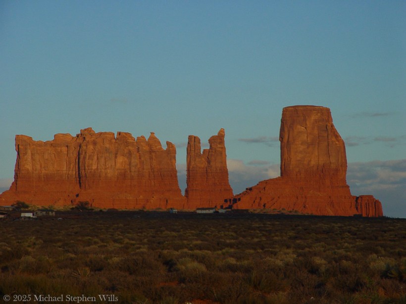
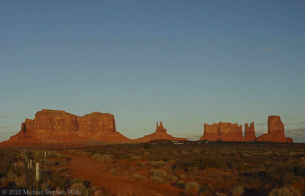
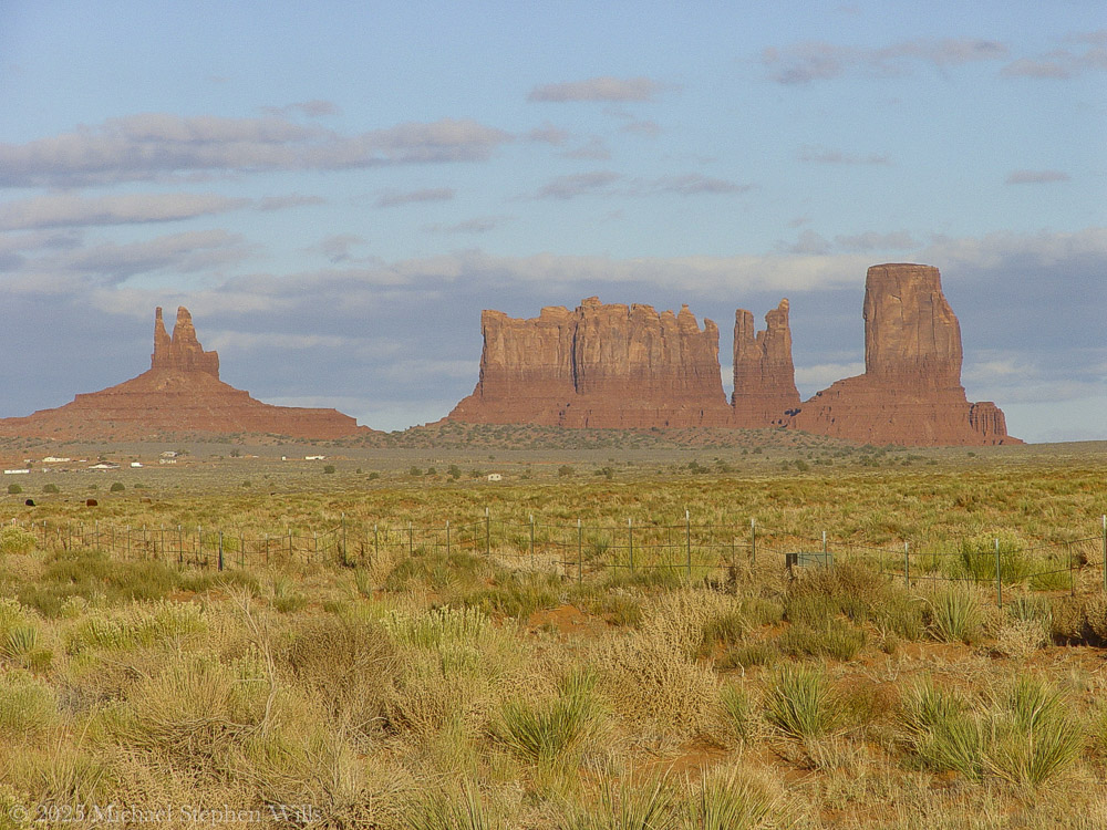
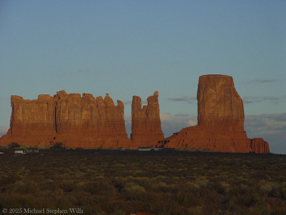
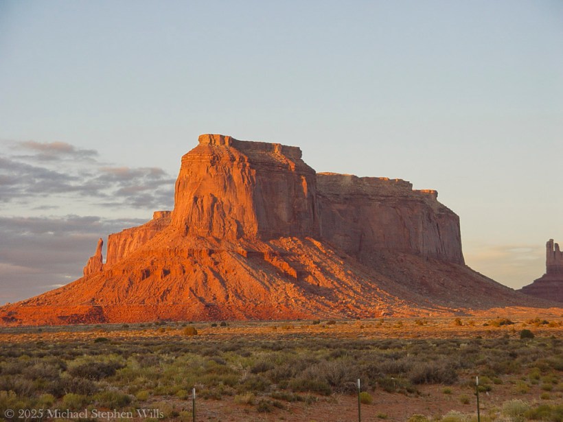
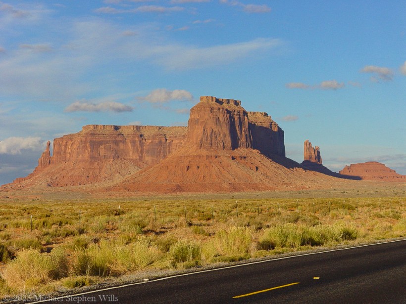
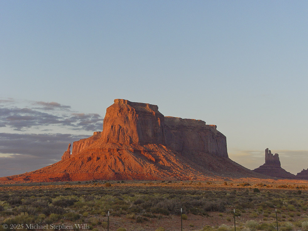
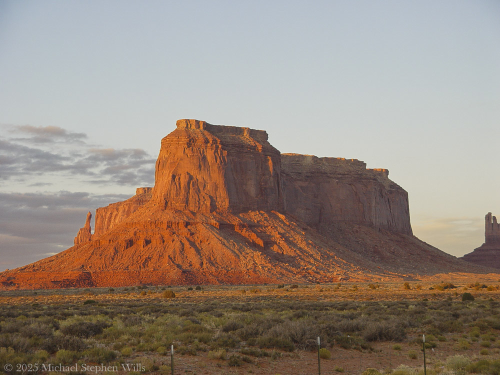
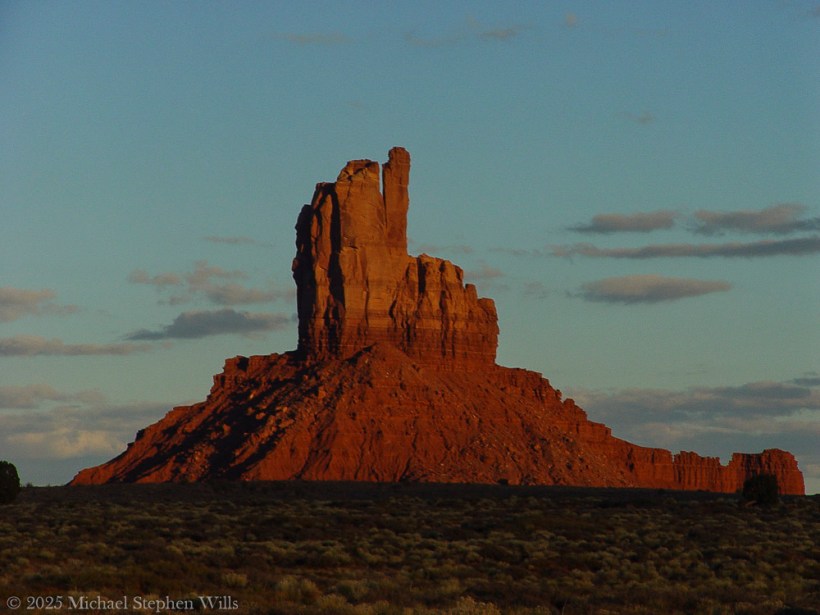
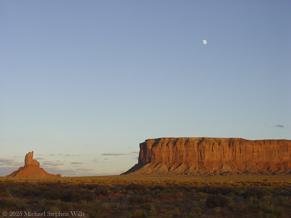
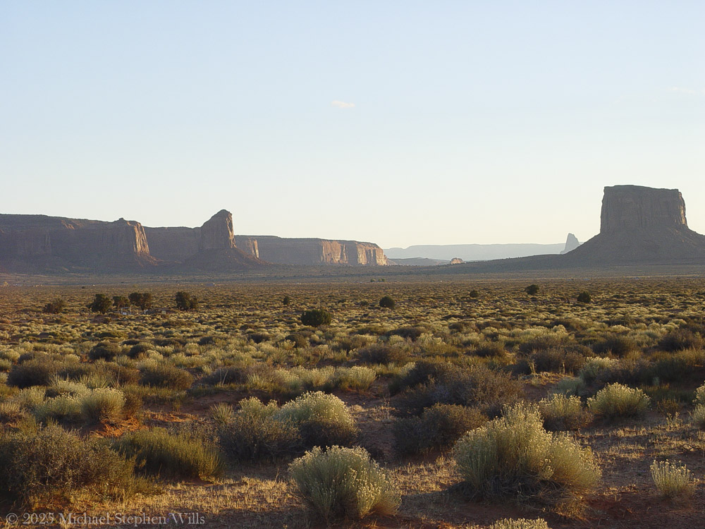
In the golden hush of this November sunset, Monument Valley stretches before us – an endless desert plain punctuated by towering red rock sentinels. The sky is vast and translucent blue, as a pale three-quarter moon rises silently above a solitary spire of sandstone. That spire is known on maps as Big Indian, a stone pillar glowing russet in the low sun. It stands apart from the mesas, its silhouette uncanny against the evening sky. In this serene moment, the land feels alive with presence. And the name “Big Indian” lingers in the air, raising quiet questions about what we call this place – and what it truly is.

From a distance, the spire does suggest a figure: tourists are told to squint, tilt their heads, and “see” the profile of a Native face gazing outward. One can imagine the first person to name it must’ve been a bored prospector, half-delirious from the heat after a lunch of canned beans, declaring: “I swear that rock looks like Uncle Joe in a feathered headdress.” And so the name stuck – a geological Rorschach test gone slightly colonial.

These whimsical titles – Totem Pole, Stagecoach, Big Indian – come not from the land, but from a long habit of outsiders labeling what they didn’t fully understand. “Big Indian” is particularly layered. The term “Indian” itself was born from Columbus’s navigational misfire, mistaking the Caribbean for Asia and its people for “Indios.” The Diné, the people who have lived here for centuries, never called themselves that. So this towering formation now bears the echo of a 15th-century directional blunder —like a name tag on the Sphinx that reads “Buckeye” because someone once thought Egypt was in Ohio. It’s a reminder: names given in haste can cling for centuries, even when they miss the mark entirely.

But beyond the names imposed by mapmakers, the spire simply is, in all its silent grandeur. In Diné lands, this valley has a different name: Tsé Biiʼ Ndzisgaii, often translated as Valley of the Rocks. In the Navajo tongue the name literally evokes “rock within white streaks around” – referring to the light bands of sediment that ring the red buttes​. Those pale streaks wrap the spire like faded paint, remnants of ancient layers of earth. Here the Diné language whispers a description born of the land itself, unlike the English names that often project an outsider’s story. Tsé Biiʼ Ndzisgaii speaks to the truth of the place: stone and light, strata and shadow. As the sun lowers, you can actually see those whitish bands catching the last glow, encircling the butte like old memory. The Diné name honors what the eye sees – the layered geology – rather than imposing an unrelated label. This spire and its neighbors were not built by human hands, though their sheer stature can feel like architecture of the gods. Millions of years of natural artistry shaped Monument Valley.

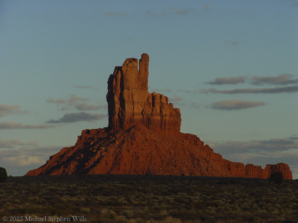
Long before any person walked here, this land was a low basin collecting sediments​. Layer upon layer of sand and silt hardened into rock, and a slow uplift in the earth heaved the basin into a plateau​. Wind and water became patient sculptors over the last 50 million years, carving the plateau and peeling away the softer material​. What remains today are the skeletal monuments of that erosion: buttes, mesas, and spires rising up to a thousand feet above the desert floor. Each is made of stratified stone – the broader bases of red shale and sandstone, and a cap of harder rock that resists the elements​. Big Indian’s sturdy pedestal and slender crest tell this story of layered resilience. In the red-orange rock, oxides of iron tint the cliffs a deep rust, while streaks of black manganese oxide – “desert varnish” – trace down their sides like natural paint​. Time and the elements have sculpted a masterpiece here.

Standing at its foot, one needs imagine the immeasurable ages of sun and storm that chiseled this lone tower from the earth. And yet, facts of geology alone fail to capture the spirit one feels in Tsé Biiʼ Ndzisgaii. The Diné know that spirit well – this valley is sacred to the Navajo Nation​. To them, these colossal rocks are alive with meaning. The people have lived and wandered among these mesas for centuries, blessing the land with their stories and prayers.

In Navajo cosmology, the landscape itself is imbued with life and purpose. The buttes are often seen as ancestors, guardians, or holy figures watching over the People. For example, the famous twin buttes called the Mittens are said to be a pair of spiritual beings – one male, one female – forever facing each other across the valley, protecting and balancing the land​. Another hulking mesa, Sentinel Mesa, is known as a “door post” of the valley, a guardian at the entrance​, paired with another butte as the opposite door post​. The valley, in the Diné way of seeing, resembles a great hogan, a home blessed by the gods: the mesas at its threshold are like the posts of a doorway, and a butte called The Hub is imagined as the central fire hearth of this immense home​.

In this way, the Diné landscape is a living, storied environment. Even the spindly formations carry sacred narrative. Seven miles southeast from Big Indian stand slender pinnacles known to the Navajo as Yei Bi Chei, named for the masked spiritual dancers who emerge on the last night of a winter healing ceremony​.

Each dawn, as the first light breaks over the mesas, it’s said the Navajo families come out of their hogans to greet the sun with prayers – their doorways always face the east to receive blessings of the day​. In the same way, the great stone hogan of Monument Valley opens eastward, with its door-post buttes and its eternal fireplace. In Diné worldview, earth and sky are intertwined with their lives; they speak of Mother Earth from whom they emerged and to whom they owe care​. Here in Monument Valley, it is possible to feel that harmony – the sense that every column of rock, every whispering juniper shrub, every beam of sunlight and moonrise is part of a whole living tapestry.

We watch as the moon climbs higher above the Big Indian spire, its silvery light softening the rock’s hard edges. This place has known many names and will outlast many more. The Paiute people who roamed here before called it “Valley Amid the Rocks” and wove myths of gods and giants into its features​. Later came the labels of explorers and filmmakers: Monument Valley, a monumental canvas for Western legends. And of course, the simplistic tag Big Indian for this lone rock – a name that says more about those who coined it than about the land itself.

Names, in the end, are stories we tell about the world. The colonial names imposed here are like brief echoes across the ages, while the Diné stories run deep as the red earth. The Diné prefer to call themselves Diné – meaning “the People”​– and they call this land by names that describe its true character. I imagine that to the People, this spire might be thought of not as an “Indian” at all, but perhaps as a sentinel or an old friend standing watch. Its Diné name, if it has one, would likely emerge from its form or its role in a story, spoken with reverence.

As dusk turns to twilight, an immense peace settles. The monolith before me is no longer just Big Indian on a map; it is an ancient entity shaped by time and honored by generations. In the silence, we can almost hear the land speaking in the old language – telling of how it was born from oceans and sand, how it saw the first people wander through, how it endures through centuries of memory. The rock shares with us a moment beyond names: just the whisper of wind, the glow of moon, and a feeling of connection and wonder. This is Monument Valley, Tsé Biiʼ Ndzisgaii, in all its truth. In this contemplative dusk, I bow to the tower of stone, misnamed yet never truly defined by that misnomer. It remains what it has always been – a creation of earth and spirit, a witness to history, a source of humble awe. Tuning to leave, I softly speak a word of thanks – Ahéheeʼ – grateful to have listened, if only briefly, to the sacred voice of the valley.


Bibliography

Encyclopædia Britannica – Tribal Nomenclature: American Indian, Native American, and First Nationbritannica.com (origin of the term “Indian” as a colonial misnomer)

Navajo Nation Parks & Recreation – Monument Valley (Tsé Bii’ Ndzisgaii)navajonationparks.orgnavajonationparks.org (official site detailing Monument Valley’s geology and formation)

Robert S. McPherson – Monument Valley. Utah History Encyclopediauen.orguen.org (history, geology, and indigenous lore of Monument Valley)

Aztec Navajo County – Monument Valley PDF Guideaztecnm.comaztecnm.com (descriptions of formations, including Navajo perspectives on their meanings and names)

Navajo Word of the Day – Tsé Biiʼ Ndzisgaiinavajowotd.com (explanation of the Navajo name for Monument Valley, meaning “white streaks in the rocks”)

Enter your email to receive notification of future postings. I will not sell or share your email address.

Guardians of the Plateau: Brigham’s Tomb, the Stagecoach, and the King on His Throne

Here is a journey to Brigham’s Tomb in Monument Valley, reflecting on the land’s timelessness, silent presence, and the profound connection between the observer and natural formations.

He did not come seeking answers, nor was he lost. The road had summoned him—as it had summoned others before him—and he followed its arc with the steadiness of one who does not hurry time. The sun was descending behind him, slow and inevitable, casting long golden blades across the plateau. That was how it wanted to be seen, and he did not interfere.

He had come this way before in dreams, further south where the great stone mittens reached into the sky. There, the land had risen in clarity, each formation distinct in its declaration. But now the evening had deepened, and the land changed its tongue. It spoke more slowly. With greater weight. And he listened.

The air was thin with silence. Even the wind moved differently here—more cautious, more reverent. And then the shapes came into view. Not suddenly, but as if they had always been there and were only now permitting themselves to be noticed.

Here stood Brigham’s Tomb.

On the way to Monument Valley Tribal Park as the sunset for this view on Sullivan Road (Route 163). Navajo County, Arizona. Brigham’s Tomb. On the way to Monument Valley Tribal Park as the sunset for this view on Sullivan Road (Route 163). Navajo County, Arizona. Brighams Tomb is situated six miles (9.7 km) northeast of Oljato–Monument Valley, Utah, on Navajo Nation land. It is an iconic landform of Monument Valley and can be seen from Highway 163. Precipitation runoff from this landform’s slopes drains into the San Juan River drainage basin. Topographic relief is significant as the summit rises 1,000 feet (305 meters) above the surrounding terrain in 0.25 mile (0.4 km). The mountain’s name refers to Brigham Young, the first governor of the Utah Territory. This landform’s toponym was officially adopted/revised in 1988 by the United States Board on Geographic Names after having been officially named “Saddleback” from 1964 through 1987. Some older maps will still show the Saddleback name. Geology Brighams Tomb is composed of three principal strata. The bottom layer is slope-forming Organ Rock Shale, the next stratum is cliff-forming De Chelly Sandstone, and the upper layer is Moenkopi Formation capped by Shinarump Conglomerate. The rock ranges in age from Permian at the bottom to Late Triassic at the top. The buttes and mesas of Monument Valley are the result of the Organ Rock Shale being more easily eroded than the overlaying sandstone..

It rose alone, square and solemn, its flanks pressed by the last warmth of the day. The light traced every fracture, every line of sediment like the spine of something ancient and vast. It had no vanity. Its strength was in endurance, in the simplicity of mass. The world had spun uncounted times around this throne of stone, and still it stood—unmoved, unwitnessed except by sky and the slow-growing desert at its feet.

He paused there—not because he was uncertain, but because the monument required it. Some things must be received in silence.

Their topographic relief is significant: Stagecoach rises 900 feet (274 meters) above the surrounding terrain in 0.35 mile (0.56 km), while King-on-his-Throne rises 565 feet (172 meters) in 0.2 mile (0.32 km). Each butte’s toponym has been officially adopted by the United States Board on Geographic Names—Stagecoach is named for its resemblance to a stagecoach, and King-on-his-Throne is said to resemble a monarch surveying his domain. Stagecoach’s first summit ascent was made in 1995 by John Middendorf, Carl Tobin, and Dan Langmade; King-on-his-Throne’s first was in 1967 by Fred Beckey, Marlene Dalluge, Joe Brown, and Don Liska.

To the southeast, past a stretch of ochre earth and sagebrush, rose two more forms. The King on His Throne, upright and proud, shaped as if he had emerged from the stone itself to bear witness. An artifact of erosion, also a sovereign presence—crowned in shadow and wind. There was no question of who he was. His seat was eternal, and no rider passed without first meeting his gaze.

Beside him stood The Stagecoach. Its resemblance to the name was almost too perfect, as if the form had stepped from the myth fully formed. But he knew better. It had not become a stagecoach. The coach had become it. The names were backwards, as names often are. The land had come first. All else was echo.

The giants stood together across the basin, their red-gold skin kindled in the last light. Their arrangement was no accident. One rose alone. Two more aside, bound by rhythm but not repetition. Together they formed a sequence—pause, proclamation, passage.

He walked the trail slowly, camera at his side but silent for a long while. There were things beyond framing. This was not a scene to be taken. It was a truth to be approached.

At the edge of the frame—a photograph not yet taken, but inevitable—the fence stretched taut across the scrub. Old wood. Rusted wire. Man’s line scratched against the land’s permanence. It held nothing. It said nothing. But it was there, and so he acknowledged it, as one acknowledges a child’s drawing pinned beside a mural.

Overhead, the sky was deepening into steel. But the earth still burned, even gently. The buttes and mesas were not dimmed by dusk. They only leaned inward, as if the heat of the day had carried them toward some great remembering.

He had seen many monuments in his life, but these were not monuments in the human sense. These were not built. They were born. They had no need for marble or inscription. Their gospel was in their silence, their liturgy the erosion of time itself.

He stood long, unmoving.

Not lost. Not searching. Just witnessing.

As the light slipped and the forms began to release their edges to shadow, he turned once—not away, but forward. The road still called. And the giants behind him did not diminish. They merely remained, as they always had, and always would.

Waiting.

Enter your email to receive notification of future postings. I will not sell or share your email address.

The Mesa Light Captured Them

A father and son journey to Eagle Mesa, experiencing its beauty and silence, reflecting on its history and significance within Navajo culture as the day fades.

They came north out of Chinle with the day already leaning west and the sun fallen low into the drag of horizon dust and the road ran flat and empty past rust hills and mesquite country until, turning into the sun at Mexican Water, after a long hour, at last they pulled into Kayenta where the streets lay quiet under the heavy sun and the windows of the store fronts cast their amber light out across the sand drifting across sidewalks and the wind stirred only faintly and then was still.

They left their bags in the room and turned north again without speaking. The son drove. A man, his father, sat quiet beside him and the sun slid low through the windshield and the sky was pale and cloudless and wide beyond reckoning.

The land began to rise and the road bent and climbed and fell again and then it came into view. Not slowly. Not like a curtain rising. It was simply there.

A shape in the far desert.

Like a ship that had grounded in a sea long vanished. A sheer mesa the color of blood and ochre and fire where the last of the day spilled westward and caught the rock face and made it burn.

He told the son to pull off. They stopped the car and got out and the sound of the engine fell away, the desert made no sound at all.

The man stood in the road and turned slowly. Eagle Mesa lay before him and the land stretched off in every direction and the fenceposts ran on into silence and the sky seemed to rest upon the buttes as if tired.

There were names for these places. Old names. Navajo names that spoke of eagles roosting and trees once there and water that came and went and did not come again. The mesa they called Wide Rock. The place where spirits go. He did not know the words but he knew the feeling.

On the way to Monument Valley Tribal Park as the sunset for this view on Sullivan Road (Route 163). Navajo County, Arizona. Eagle Mesa is situated 4.5 miles (7.2 km) northeast of Oljato–Monument Valley, Utah, on Navajo Nation land. It is an iconic landform of Monument Valley and can be seen from Highway 163.Precipitation runoff from this mesa’s slopes drains to Mitchell Butte Wash and Train Rock Wash which are both part of the San Juan River drainage basin. Topographic relief is significant as the summit rises 1,100 feet (335 meters) above surrounding terrain in 0.6 mile (1 km). The nearest higher neighbor is Brighams Tomb, 2.05 miles (3.30 km) to the east. This landform’s toponym has been officially adopted by the United States Board on Geographic Names. Navajo names for the mesa are “Wide Rock”, “Where the Eagles Roost”, “Water Basket Sits”, and “Trees Hanging from Surrounding Belt” because there were once numerous trees here. In Navajo mythology, Eagle Mesa is a place where spirits of the deceased may go. Eagle Rock Spire is a 300-ft tower on the northern tip of the mesa which requires class 5.9 climbing skill to reach the summit.Navajo names for this spire which resembles a perched eagle include “Eagle Alongside Mesa”, “Big Finger is Pointed”, and Tsé Łichii Dahazkani (Elevated Red Rock Sitting Up). The first ascent of the spire was made on April 23, 1970, by Fred Beckey and Eric Bjornstad. Geology Eagle Mesa is a mesa composed of three principal strata. The bottom layer is Organ Rock Shale, the next stratum is cliff-forming De Chelly Sandstone, and the upper layer is Moenkopi Formation capped by Shinarump Conglomerate. The rock ranges in age from Permian at the bottom to Late Triassic at the top. The buttes and mesas of Monument Valley are the result of the Organ Rock Shale being more easily eroded than the overlaying sandstone.

The son came and stood beside him and did not speak. The man lifted the camera and took a photograph and then another. The road behind them shimmered with the last heat of day. He took another picture his son, dressed in black, his arms at rest and the red mesa rising behind him and the shadows of their bodies cast long across the gravel and the shoulder of the road.

On the way to Monument Valley Tribal Park as the sunset for this view on Sullivan Road (Route 163). Behind Sean are the landforms Eagle Mesa and behind it Setting Hen, Bringham’s Tomb, to the right. Navajo County, Arizona

They took turns with the camera. The son caught him midstride and smiling lit by sunlight, the land stretching out all around. A man small in a world not made for men.

There was no sound but the click of the shutter and the dry whisper of wind among the sage.

On the way to Monument Valley Tribal Park as the sunset for this view on Sullivan Road (Route 163). Behind Mike are the landforms Eagle Mesa and behind it Setting Hen, Bringham’s Tomb to the right. Navajo County, Arizona

Later he would read that the rock was born of Organ Shale and De Chelly Sandstone and Moenkopi topped with Shinarump. He would know the spire they saw was first climbed by men named Beckey and Bjornstad and that it was called Tsé Łichii Dahazkani by those who’d named it before it ever had another name. He would know the mesa rose eleven hundred feet in less than a mile and that its runoff fed washes that fed rivers that fed nothing now.

But then he only stood and watched and knew it for what it was.

Not a monument to anything but time.

A stillness like prayer. A place that waits.

They lingered until the sun went and the sky turned iron blue and the shadows of the rock reached out across the valley floor and touched them where they stood. Then they climbed back in the car and drove south again and the road unwound behind them black and a single star above and the silence of the place held on inside them long after the valley was gone.

Enter your email to receive notification of future postings. I will not sell or share your email address.

Aerial Wonder: Capturing the Essence of Flight

Engines roar as planes await departure, soaring into vibrant sunsets. The sky transforms with colors, revealing a reflective world as night gradually takes over.


Bright was the sky as the engines awoke with a rumble of thunder,
Rolling the tarmac in echoes of journeys yet destined for wonder.
Cloudbanks assembled in towering billows of silver and shadow,
Lifting their faces to heaven, where sunlight had painted them golden.

Far on the edge of the runway, the steel-winged vessels lay waiting,
Southwest and Delta, their banners aloft in the warm evening fading.
Emerald-liveried Aer Lingus, a voyager bound to the island,
Glided in grace on the threshold of travel through luminous currents.

Wheels left the earth with a whisper, a moment of weightless suspension,
Gravity yielding to flight as the city unrolled far beneath us.
Golden horizons drew rivers of fire through infinite heavens,
Burning the clouds into embers that drifted in luminous torrents.

Upward we soared, where the world lay in pools of cerulean mirror,
Lakes interwoven like jewels, reflections of sunfire descending.
Billows of vapor, like castles of foam on the rim of creation,
Tumbled and rolled into canyons of mist in the twilight’s dominion.

Flame on the wings, where the heavens ignited in hues of vermilion,
Rays from the sun, like a god’s final whisper, embracing the skyline.
Shadows arose in their silence, dissolving the last glow of daytime,
Stars in their vigil awakened as night claimed the realm of the heavens.

Enter your email to receive notification of future postings. I will not sell or share your email address.

Exploring Rincon Peak: Hiking Adventures in Arizona

As we stood atop Rincon Peak, the sky darkened with the approach of a sudden thunderstorm. Below us, the San Pedro River valley sprawled, with the Mae West Peaks to the left and the legendary Dragoon Mountains straight ahead. This photograph captures that exhilarating moment—standing on the summit with the world at our feet and the wild Arizona sky closing in. Curious about how we got there and our race against nature’s fury? Join me on the blog to delve into the full adventure and explore more stunning images from the heart of the Rincon Wilderness.

The Rincons are one of 42 Sky Island mountains isolated from each other due to gradual warming and drying climate changes since the last ice age, 10,000 years ago. While this marvelous environment of oak and pine forests is accessible only on foot and with significant effort, it is visible from every point of the Tucson valley, home to a million inhabitants.

The name ‘Rincon,’ Spanish for ‘corner,’ reflects the mountains’ shape as they enclose a space on the west and northwest. This area, formerly used for ranching, is now being developed for tract housing. In contrast, the mountains themselves are preserved as wilderness, with parts designated within the Saguaro National Park and the Coronado National Forest.

In the past 51 years, I have been lucky enough to visit the Rincon Wilderness interior four times, shouldering different style backpacks onto the mountain and walking in different boots. My first trip was during college in the 1970s, when a party of six of us left from the end of Speedway, heading up the Douglas Springs trail. The climb was an exercise in desert survival that several friendships did not survive, replaced by new friends met on Mica Mountain. I have no photographs from that experience, only memories and the backpack.

Decades later, reconnecting with Arizona in 2004—thirty-one years after that first experience—I took no chances. This time, my attempt on Rincon Peak was a success. I reduced risk and effort, though not eliminating them, by hiring a guide for the four-day trip. We reached Rincon Peak via the Turkey Creek Trail out of Happy Valley, climbing a mountain buttress with views that widened and lengthened with every step.

Capturing these moments, I took several photographs during that experience. Two years later I added a landscape of the peak at sunset.

Along the Turkey Creek trail, Sego Lilies bloomed among a stricken oak and drying grasses, offering a vivid glimpse into the region’s delicate ecosystem. It is the winter rains that trigger such a bloom.

Sego Lilies -- CLICK ME!!!!

Enthralled by their beauty, we paused while I unpacked my gear to photograph the Sego Lilies growing along the trail.

Sego Lilies -- CLICK ME!!!!

When we reached Deer Head Spring at the top of Turkey Creek Trail on April 27, 2004, it was a moist spot with no accessible water. With only about a gallon of water each remaining, we pressed ahead to Heartbreak Ridge and climbed into Happy Valley Saddle, where, thankfully, the creek—though low and full of algae—was usable. It was here that I caught my first glimpses of Rincon Peak, looking across the aptly named Heartbreak Ridge and Happy Valley Saddle.

Distant View of Rincon Peak-- CLICK ME!!!!
Telephoto view of Rincon Peak -- CLICK ME!!!!

From Rincon Peak, the view to the south was breathtaking. The white rocks at the lower right formed the Valley of the Moon wall. Below lay the San Pedro River valley, with the Mae West Peaks at the left margin and the Dragoon Mountains with Cochise Stronghold at the center. I took this photograph around 12:30 PM on April 28, 2004, just as a thunderstorm was approaching.

View from Rincon Peak -- CLICK ME!!!!

Rotating the camera to the south-southwest, the view stretched over the Valley of the Moon to the eastern Tucson Valley and the Sky Islands of the Whetstone Mountains (Apache Peak), with the Santa Ritas behind them. In this vast landscape, the works of man are overpowered by sky, rock, and distance.

View from Rincon Peak -- CLICK ME!!!!

We made a hasty departure ahead of the thunderstorm. Attempting the peak that day had been a touch-and-go decision, but we reached the summit with moments to spare.

On the morning of April 29, 2004, the day after reaching Rincon Peak, I set up my tripod near our Happy Valley Saddle camp. In the serene early morning sunlight, I captured images of Rincon Peak, reflecting on the previous day’s ascent.

Rincon Peak from Happy Valley Saddle, dawn -- CLICK ME!!!!

On the day we descended to the X9 Ranch via the Rincon Creek trail, we were granted a unique opportunity. My guide’s grandfather had a homestead at the X9, and his access to the trailhead through private lands opened this ro ute for us. That evening, I took a photograph of the sunset on Rincon Peak from the X9 Ranch, looking east from the ‘Rincon’—the corner formed by the massifs of Rincon Peak, Mica Mountain, and Tanque Verde Ridge.

The X9 ranch sits in the Rincon (spanish for corner) made by the massifs Rincon Peak, Mica Mountain and Tanque Verde ridge.

Two years later, on the evening of November 2, 2006, I climbed the Tanque Verde trail in Saguaro National Park East for about 30 minutes to reach a vantage point of Rincon Peak. Intending to capture the peak bathed in golden light, I waited until just before the sun set behind the Tucson Mountain. Afterwards, I raced the sun hiked back to the car. In my hurry, I tripped on a stepped turn and dove headfirst into a large prickly pear cactus. It was a very painful experience. Large spines pierced my face, while tiny, pesky spines covered my chest and back. The large spines, not being barbed, came out easily, but I needed to visit a physician to remove the rest.

Click me for a framed version of this photograph
Rincon Peak from the X9 Ranch-- CLICK ME!!!!

Enter your email to receive notification of future postings. I will not sell or share your email address.

Passing…..

…remembering our time on the cusp of the pandemic

After 2 pm check in we interrupted unpacking for a sundown beach walk, IPhones and Sony Alpha 700 camera in hand on the last evening of 2019. There is a business on A1A, the main road through town, advertising “beach weddings” and “elopements.” Here, using the 18 – 200 mm f3.5-6.2 lens, I spied this grouping of a mature couple holding hands, minister in attendance, for a wedding ceremony witnessed by young adult children on the right, parents (?) left. The groom’s shorts contrast with the bride’s white gown.

Sunlight, low in the western sky, was perfect for mirror-like reflections in the retreating surf.

A given of the Atlantic beach is the late afternoon light, best for capturing figures against the ocean.

Written below the high tide mark, a message inscribed, impermanent in spite of the deep cuts.

I have practice framing sunsets against beach development. Cannot complain as we enjoy our beach side condo.

A slide show of these images.

Copyright 2024 All Rights Reserved Michael Stephen Wills

“Some Enchanted Evening” Riff

Discover the charm of Cocoa Beach’s enchanted sunset where Olaf, the endearing snowman from “Frozen,” joins athletes in a celebration of imagination and sport on Florida’s magical Space Coast.

Olaf, with his carrot nose and coal-button smile, is the epitome of the whimsy and innocence that fills the hearts of those who dare to dream. He’s the spark of childlike wonder that persists even as the day gives way to night. As the sun dips below the horizon at Cocoa Beach, the playful contrast of a snowman who loves warm hugs stands out against the backdrop of Florida’s Space Coast—a place known for its rocket launches as much as its sun-soaked shores. It’s here, on this stretch of sand, that imagination and reality dance in the twilight, blurring the lines between a tale from the silver screen and the tangible joy of a beach evening.

The presence of Olaf in this coastal setting is an unexpected delight, akin to the wonder of snowflakes in summer. He is more than a snowman; he is the manifestation of Elsa’s magic, a symbol of enduring friendship and the embodiment of the happiness that comes from simply being alive. His creation, a whimsical result of Elsa’s ice powers, speaks to the capacity we all have for creation and transformation. The Olaf suit, worn by a young athlete, represents not just a beloved character, but a beacon of joy and the power of sportsmanship that enlivens the USSSA National All State Championship.

Don DeDonatis, CEO of USSSA, speaks of the excitement of hosting a tournament that is a “celebration of talented softball players from around the country.” Indeed, it’s a parallel to the celebration of life that Olaf represents—where each athlete, like each snow crystal, is unique and contributes to the beauty of the whole. The tournament at the Space Coast Complex in Viera, Florida, is a tribute to the hard work and dreams of young athletes, much like the dream that brought Olaf to life.

The sunset photograph of Cocoa Beach, snapped in December 2023, is not just a capture of a moment in time, but a timeless reminder of the enchantments that life offers. The beach becomes a stage where each footprint tells a story, and each wave sings a song. It’s a place where memories are made, where the spirit of characters like Olaf can leap out of their fictional realms and into our world, if only for an evening.

Brevard County’s Space Coast is a junction where the vastness of space meets the intimacy of earth, where shuttles launch into the cosmos while children build sandcastles, and where a snowman can stand on a beach without melting, embraced by the warmth of the setting sun rather than the chill of winter. It’s a testament to the human spirit’s boundless creativity and our ability to find joy in the juxtaposition of opposites.

This enchanted evening is a tapestry woven from the threads of fantasy and reality, sport and art, the cosmos and the coastline. It’s where the horizon kisses the sea, where the sky becomes a canvas for the sun’s parting masterpiece, and where Olaf, our friend from “Frozen,” reminds us that magic is not just in the realm of fairytales but all around us, in every grain of sand, in every sunset, and in every heart that believes in the wonder of one enchanted evening.

Copyright 2024 Michael Stephen Wills All Rights Reserved

Tides of Discovery: A Hawser’s Journey to Cocoa Beach

Discover the mysterious journey of an ocean-worn hawser on Cocoa Beach. Join me in unraveling its sea-tossed tales and the profound messages the tides bring to our shores.

A Serendipitous Morning


As I strolled along the familiar expanse of Cocoa Beach, a silver mist hung over the horizon, blurring the line where the Atlantic whispered to the skies. My footsteps, a quiet percussion against the hush of dawn, were the only sound until the waves added their chorus. I was here to greet the sunrise, a ritual that never failed to ground me, but today, the ocean had laid out a surprise – a hawser, heavy and worn, beached like a leviathan of the deep.

Cocoa Beach, Brevard County, Florida on the Space Coast

The Relic of the Sea


There it lay, a colossal rope, its many fibers frayed and clinging to sand, a testament to its battle with the ocean’s might. This hawser, a lifeline once to vessels that dared to navigate treacherous waters, was now at the mercy of the tides that once heeded its command. I approached, curious, reverence growing within me for this unexpected relic of human endeavor.

The High Tide’s Offering


The hawser’s journey to my path was a story written in the ebb and flow of the tides. The high tide, under the pull of the moon’s invisible hands, had surged with purpose, pushing this massive rope to the shore as its offering. High tides are nature’s way of reaching out, touching the land, and sometimes, they bring gifts from the depths, each with a tale to tell.

A Tapestry of Experiences


Touching the hawser, I felt connected to the lives it must have touched, the storms it weathered, and the unspoken histories it held. Each thread was a narrative, a voyage, a storm survived. The macro images of the hawser’s frayed ends resembled the intricate work of a natural tapestry – artful, chaotic, yet purposeful. It was a mosaic of experience, and now, it was a part of Cocoa Beach’s landscape.

The Dance of Man and Nature


The hawser at the foot of the lifeguard station stood as a symbol of humanity’s interaction with the mighty sea. We build structures, craft vessels, and forge hawsers, asserting our presence. Yet, the tides remind us of our place within the grand tapestry of nature. Tides dance around our creations, sometimes reclaiming them, other times presenting them back to us, reshaped, redefined.

Reflecting on the Tides


As I sat by the hawser, the sun broke free from the horizon, casting golden hues over the beach. The tide was retreating, pulling back into the ocean’s embrace, leaving behind patterns on the sand, and the hawser – a silent sentinel of the shore. It was a moment of reflection on the power of the tides, the constant cycle of giving and taking, and the marks they leave upon both the earth and our lives.

Conclusion: The Tides of Life


The tides had brought the hawser to Cocoa Beach, and with it, a moment of connection to the vastness of the sea and the shared journeys of all who traverse it. As I walked away, the hawser remained – a fixture until the tide would rise again, perhaps to claim it back or offer another token of the ocean’s depths. The power of the tides is a powerful metaphor for life’s ebb and flow, each wave a new beginning, each retreat a chance to reflect on the imprints left behind.

Copyright 2024 Michael Stephen Wills All Rights Reserved

Above the Finger Lakes: A Winter’s Eve Flight

Joint me to gaze out upon a mesmerizing view of winter’s embrace over the Finger Lakes, where the setting sun paints an ephemeral masterpiece of ice, water, and twiligh

As I soared into the heavens, bound for Syracuse on the 9th of February in the year 2024, I found myself cradled in the gentle embrace of the port side of our metal chariot. The world unfolded beneath me; a tapestry of natural splendor painted in the golden hues of the setting sun. The view to the west, a grand panorama, beckoned my gaze, luring my senses into the wild embrace of Upstate New York’s finest landscapes.

Flying into Syracuse, February 9, 2024 we sat on the left (port) side of plane, this view to the west took in Canandaigua Lake, Bristol Mountain Ski Area, Honeoye Lake, Hemlock Lake (Canadice Lake is not visible).

Below, Canandaigua Lake lay stretched out like a slumbering giant, its waters glistening with the last kisses of daylight, a mirror to the sky’s fiery canvas. How wondrous it was to perceive the world from such heights, to witness the lake’s serenity from the abode of the gods. It seemed as if Canandaigua herself was remembering whispered tales of ice fishermen and quiet boathouses locked in the winter’s frosty grasp.

Off to the south, the proud shoulders of Bristol Mountain Ski Area rose in defiance against the winter’s chill. The mountain’s snow-laden slopes, carved with the meticulous precision of skiers and snowboarders, reflected the sun’s dying light, a beacon of winter’s joy amidst the sprawling lands. I could almost hear the muffled laughter of families and the swish of skis carving their ephemeral signature upon the mountain’s white canvas.

Nestled in the mountain’s shadow, Honeoye Lake revealed itself, a slender and unassuming sliver of tranquility. Its presence was like that of a quiet companion amidst the grandeur, a reminder of the simpler pleasures—frozen waters awaiting the spring thaw, the promise of lush greenery peering from beneath the white shroud of winter.

Beyond, where the earth kissed the sky, Hemlock Lake offered its secluded beauty, a hidden gem amongst its more renowned siblings. Though Canadice Lake remained shyly concealed from view, I knew it too slumbered there, a silent sentinel guarding the land’s secrets. Together, these lakes stood as custodians of a silent world, the guardians of a tranquility that seemed untouched by the passage of time.

As the plane banked gently, the clouds above me caught fire, ablaze with the colors of the dying day. Wisps of vapor painted streaks of orange, purple, and pink across the expansive canvas, a celestial masterpiece unfolding before my very eyes. The clouds seemed to dance with the joy of existence, a choreographed performance to the symphony of the setting sun.

I found myself lost in the moment, a solitary figure suspended between heaven and earth, caught in the embrace of an ephemeral beauty. The world below whispered of untold stories, of winters past and springs to come, of the endless cycle of life that pulsed beneath the frost. It was a moment of profound connection, a fleeting communion with the heartbeat of the planet.

Reflections on the Inlet: The Convergence of Realities

In the shadow of McGraw Tower, Natan grapples with surreal encounters and mystical occurrences, questioning the nature of reality itself. Open my blog to uncover the mysteries of McGraw Tower and Natan’s journey into the heart of the extraordinary.

Continue reading “Reflections on the Inlet: The Convergence of Realities”