Late Autumn Ithaca 2

A family story and artistic expression

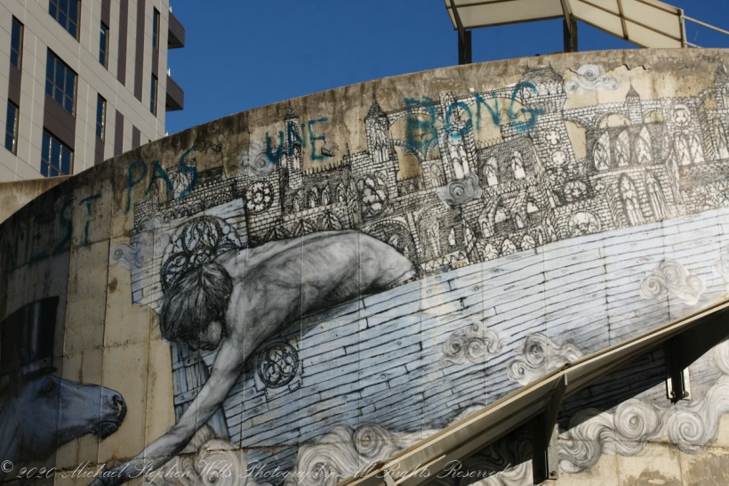
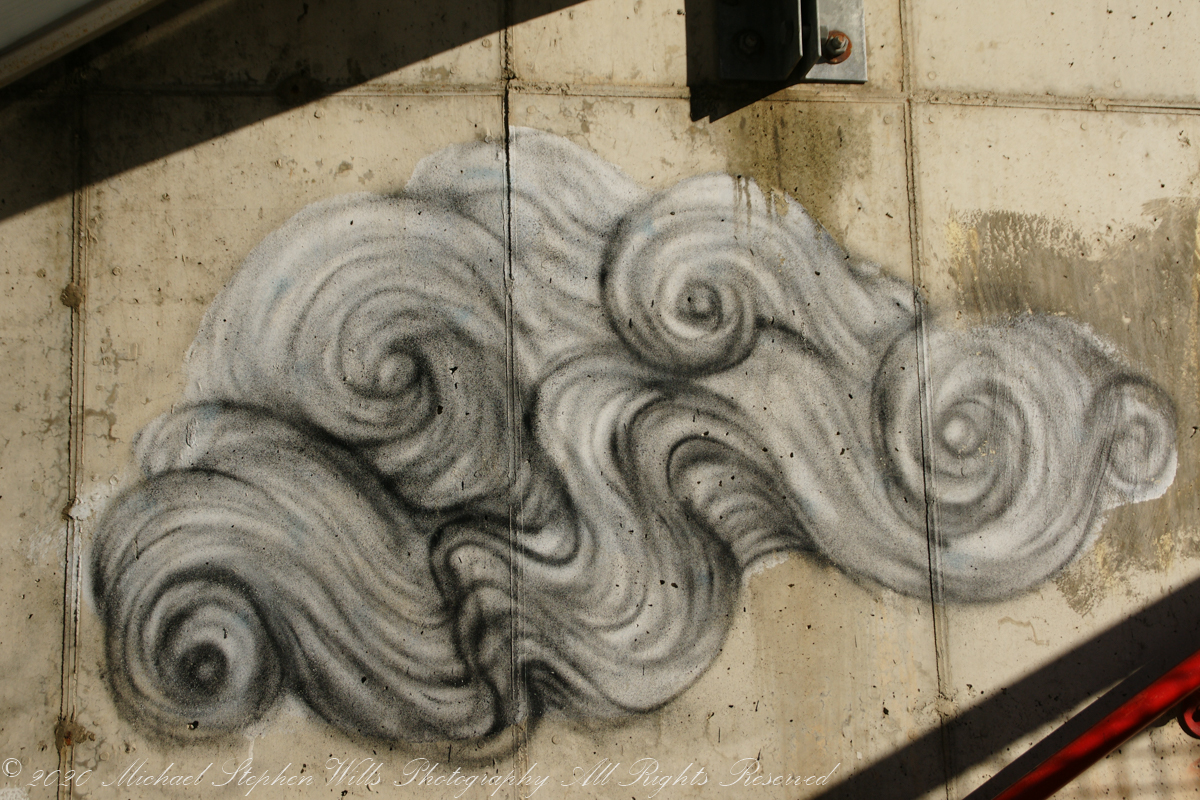
Across the street from Tompkins County Public Library, next to City Hall, is the Green Street Garage decorated with artistic graffiti by the French artist Amir Roti.

Completed during Fall 2012. This artist’s style is seen around town, black and white with touches of blue of inscrutable, dream inspired (?) scenes. The winters winds do whip through these streets.

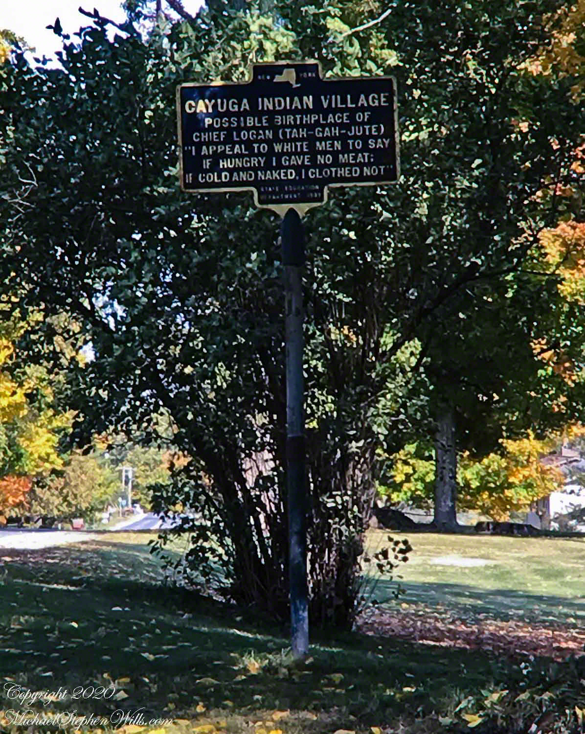
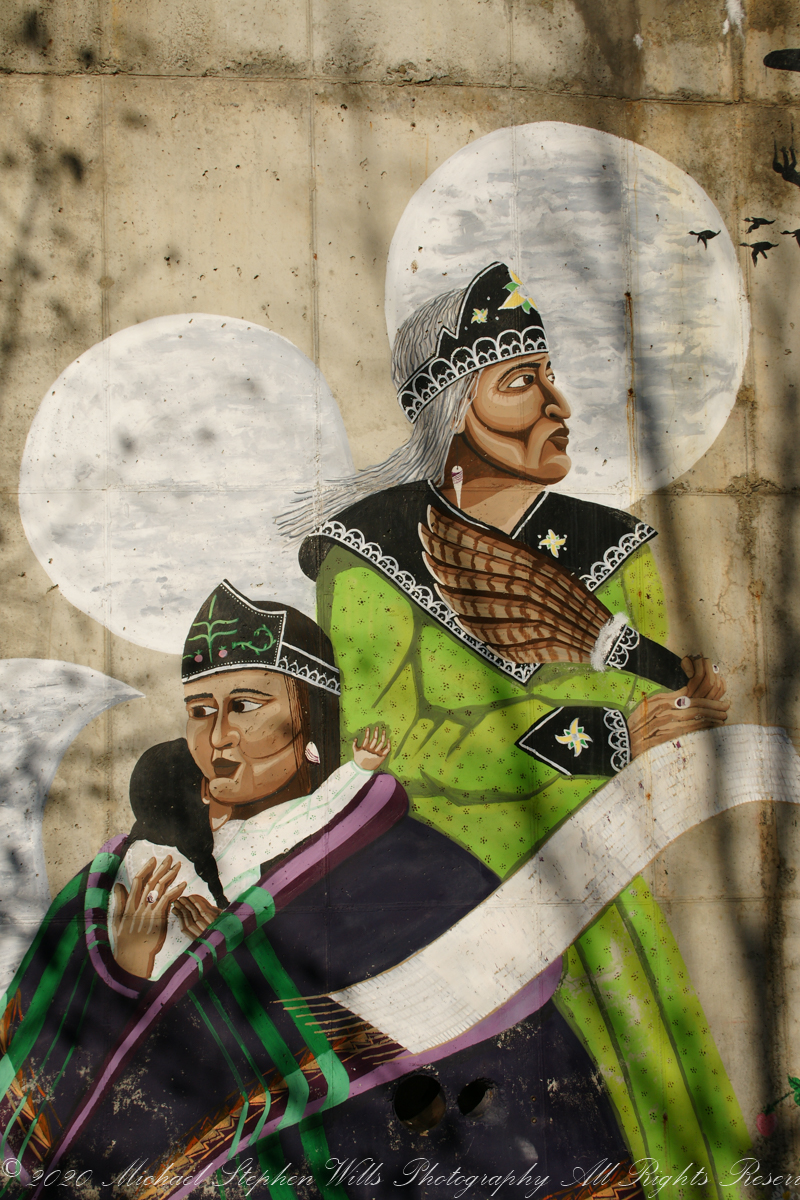
A few steps away, some propaganda. I recognize the characters as Native Americans from the feather object. Doing some research I found it was completed in 2014 by Brandon Lazore here is some text from the artist, “”Women’s Nomination” is dedicated to all Haudenosaunee women. A silhouette of “Sky Woman” falls from Sky World. In moments, she will be caught by flying geese & put on turtle’s back – “Turtle Island.” In her hands she holds roots of the 3 sisters – corn, beans, & squash. The woman in green represents Clan Mother, grandmother, elder. The woman in purple is her daughter & the baby is her daughter’s daughter. The wampum belt is the Women’s Nomination Belt which represents, among other things, the right that Haudenosaunee woman have to give their child a clan, to chose names of children, & to choose chiefs. Strawberries represent medicine like mother’s love is medicine to a child. The moon represents fertility & how it’s cycle plays a huge role in every woman’s life. The Sky Domes are inspired by traditional art decorating our clothing for centuries. It represents the sky world & the plants that were given to us – corn, beans, squash, & tobacco.” Haudenosaunee are also known as Iroquois.

To counterbalance the sentimentality of the mural here is historical context, a family anecdote from George Washington Schuyler of Ithaca, New York from the life of his paternal ancestor, Peter Schuyler, known to the Mohawks as “Quidor,” as told to the author, John Fisk, in 1881. “After a severe tramp in the wilderness, half starved with hunger and cold, Quidor came on evening upon an encampment of Mohawks, where he was cordially welcomed. In a few moment he was seated before a bright blaze, with a calabash of hot soup, the most delicious he had ever tasted. Presently, when he dipped his rude ladle once more into the kettle and brought up a couple of parboiled human fingers, it gave him a queer turn, but he repressed all show of feeling and quietly asked a feathered chieftain, ‘What is this soup made of?’ The chief as calmly replied, ‘Of a Frenchman we killed this morning; isn’t it good?'” Words even more significant because I would soon walk past the grave of George Washington Schuyler, laid to rest 132 years ago.

References:

The Dutch and Quaker Colonies, Volume II, by John Fisk, The Riverside Press, Cambridge, 1899, p214 “Peter Schuyler and his influence over the Mohawks”.

The 2019 Ithaca Mural Map

Copyright 2020 Michael Stephen Wills All Rights Reserved

Late Autumn Ithaca 1

Dredging the past

This Sunday past I parked the car downtown (free parking Sundays) and walked the walk, carrying the Sony Alpha 700 with the variable 18-200 lens. Today is a contemplation of beginnings. Here is a mural dedicated to the founding of the Cornell Library Association, titled “Ezra Cornell”, completed 2016 by Nestor Madalengoita.

It was the 1779 Sullivan – Clinton Revolutionary War expedition against British Loyalists and allies, the Iroquois confederation, that opened up Central New York to settlement, making possible the 1,400 Dewitt acres that is now the City of Ithaca, named, strangely, after an Aegean island with Hector Street, our road to downtown, recalling the foremost defender of Troy.

Click Me for the complete post with photographs.

Copyright 2020 Michael Stephen Wills All Rights Reserved

Thayer Preserve, Lick Brook

Former farm land

Sandbank Road climbs from the valley of Ithaca city to the rural peneplain on the way to Buttermilk Falls, we passed the sign for this preserve many times, today we explored this place, new to us. The trail descends to Lick Creek canyon.

Click photograph for larger view. Use combination keys to enlarge/reduce: Ctrl+ (Control / Plus) and Ctrl- (Control / Minus)

We stopped to enjoy the open space of a powerline clear cut where the trail intersects the creek bed. Here we turned, following the water.

Off trail to the creek bed.

Click to view my Finger Lakes photographs on Getty.
Copyright 2019 All Rights Reserved Michael Stephen Will

The path beckons

just around the corner

What is there, just beyond?

Click image for a larger version.

Click Me for another Malloryville post, “Formed By Water.”

Copyright 2020 Michael Stephen Wills All Rights Reserved

Chief Logan

Spring Fed Pond

Reputedly, the life of a famous Native American orator, had its beginning on a spring fed pond we know today as Jennings Pond.

We briefly visited Jennings Pond in yesterday’s post, that day I also captured the 1932 New York State Department of Education historical sign with attribution of Chief Logan’s birth to this place and some of his most famous and notable words, “I appeal to white men to say, ‘If hungry Chief Logan gave no meat. If cold and naked, he clothed me not.”

Heading photograph: Purple Asters found along Jennings Pond by Michael Stephen Wills

Copyright 2020 Michael Stephen Wills All Rights Reserved

Jennings Pond

Buttermilk Falls Source

Tom Knight, “has been delighting children and their grown-ups with his original, interactive, musical puppet show since 1988,” in 2018 Pam, myself and the grandchildren were lucky enough to catch his act at Cornell University Johnson Museum. His CD, “Purple Pumpkin Pie” is in the car and, pre-Covid, I’d play it in the car while riding with the grandchildren.

“Jennings Pond,” a song on that CD, mentions a local town, Danby. Until last week I did not think twice about it. Driving into Ithaca, heading north on Route 13, there’s a compelling view down a valley. I’ve taken exploratory drives down there on the West Danby-Spencer road, seeing what there is to see. A week ago last Sunday, turning left at West Danby, up the hill forming the east valley wall, on Station Road, then Bald Hill Road, passing by the Finger Lakes Trail through Danby State Forest, on the right I spied a compelling open area, a pond, and this sign….

I proceeded onto a footbridge over the pond outlet, the source for Buttermilk Creek,…….

…and continued to a footpath, southeast and away from the pond. Toward the Finger Lakes Trail? I left this adventure for another day.

Copyright 2020 Michael Stephen Wills All Rights Reserved

A Day at Iron Kettle Farm

We miss you, Mom.

One Saturday of October 2012 we enjoyed this last outing with my mother Catherine Ann Wills.  She passed away June 2013 at the age of 90 years.  We miss you, Mom.

A display of large pumpkins near the entrance to the Iron Kettle Farm.

Grand Entrance Display

Enter…if you dare….Corn Mazes are popular tourist attractions and are not simply corn fields. The plantings must be made later, planted thinner and fertilized less than those used for crops.

IronKettleFarm_121006--12

These small, inedible squash, once dried and hollowed out, become gourds. The plant is in the Cucurbitaceae family of the genus Lagenaria. The squash on this table are too small for anything but displays and decorations, such as centerpieces. Great fun and make and enjoy.

Ornamental Squash / Gourds

These ornamental squash, also know as cucurbita are not are large enough for use as food. When dried, will last a long time.

Ornamental Squash / Gourds

Take your pick of pumpkins….

Take your pick

…the pumpkins are sorted by size and price.

If you enjoy my work….click this link for my OnLine gallery. Your support is appreciated. Thank You.

The pumpkins are sorted....
We chose small to medium sized pumpkins.

Our choice.....
Thankfully, the trees kept to their usual habits and did not talk to us today.

Thankfully, the trees....
My dear wife, Pam, was in her element.  She loves gardening.

Pam, in her element
We left the wheelchair at home and Mom enjoyed exploring the exhibits, watching people and the exercise.

Mom was up and about this day...

Copyright 2023 Michael Stephen Wills All Rights Reserved

A Perfect Afternoon On Beebee Lake repost

Anticipating Our Tenth Wedding Anniversary

After work on a 2008 Friday afternoon in October we sped over to Beebee Lake on the Cornell University Campus to catch the late afternoon glow……

Click Me for the complete post with photographs.

Copyright 2020 Michael Stephen Wills All Rights Reserved

Kame = Pile

Kettle and Kame Topography

Hard on the defunct gravel pit of the northwest side of the preserve is the deposit of glacial rocks washed to some extent by melting ice the former owners of the pit were turning over for profit with the averted result of destroying the water sources for the ecosystems of the future preserve.

The deposit is called a kame. Kames are the obverse of kettles, formed with an enormous remnant of glacial ice melts in place leaving a substantial depression. A kame is formed when earth gathers in a depression formed by meltwater running over a glacial surface. When the glacier melts (in this area the ice wash a mile high), the washed earth is left as a steeply sided pile we experience as a hill.

Water flowing beneath glaciers forms the long, ridged hills, eskers, we explored in yesterday’s post.

The forested land of this video the kame, upper left, shown in the header, an IPhone7 photograph of GoogleEarth. Also marked is a path for the primary esker, the bog formed by a kettle and another kettle that is now a pond. Click me to view a pdf file saved from GoogleEarth. It provides a clearer view of the header image.

Click me for better experience viewing the following video. To do this from WordPress Reader, you need to first click the title of this post to open a new page. Note the replay icon (an arrow circling counter-clockwise.

Click Me for the first post of this series.

Thank You for visiting. Here is a recapitulation of Malloryville Preserve.

Copyright 2020 Michael Stephen Wills All Rights Reserved

Long, Ridged Hill

A Look at an Esker

Well formed, sinuous, graded on both sides, eskers can be mistaken for man-made earthen structures, such as railroad embankments. Here is an example, nine-tenths (0.9) of a mile long substantial enough to direct the flow of Fall Creek. On entering the Malloryville esker bed the stream makes a right angle turn.

Here we are at the foot of the primary esker of Malloryville Preserve (it is marked as such on the information placard of this series first post). The slope to the right is the esker. A swamp lies to the right.

This video provides a better feeling for this esker.

Click me for better experience viewing the following video. To do this from WordPress Reader, you need to first click the title of this post to open a new page. Note the replay icon (an arrow circling counter-clockwise.

Click Me for the first post of this series.

Copyright 2020 Michael Stephen Wills All Rights Reserved