Irish Countryside: the Old Aghameen School

A schoolhouse ruin on the Cooley Peninsula near the Tain trail

Click any photograph to visit my online gallery

On Monday, June 9, 2014 John Mills, the first cousin of my mother, Catherine Wills nee McArdle, showed us the ruin of the schoolhouse used in the 1930 / 1940’s and which he attended as would Catherine if her parents hadn’t emigrated to Canada in the 1920’s.  Free public schooling was mandated in Ireland from 1831 and by the 1850s most Irish parishes had a schoolhouse, such as this in Ballymascanlon civil parish, as part of the National Schools.  When this piece was first published, Malachy Mills (a cousin), left a comment and clue…the name is Aghameen School.  The following information spooled out from that.

There is an Irish language site, Duchas.ie, with listings for Aghameen, a Louth township, the very one of the school and, very rightly, it is the name of the school.  There is even information from a teacher, Bean Ui Riada, who taught there 1937 – 1938, and posted information about local place names and legends.  Here is the link to his postings.  I learned from him that Aghameen is An tÁth Mín in Irish and means “field of the mountain meadow.”  You can see from the photographs the site is on the side of a mountain, pine forests all around.

Throughout her life my Mother had correspondence with her cousins who learned how to write in this very school.

The school existed at least since 1842. In private communication arising from this blog posting I learned a friend’s great, great grandfather, Denis Joseph Doherty, came from Donegal in that year to teach in the school and married a fellow teacher, Margaret Kane who was the girl’s school teacher. They raised a family while living at the school until moving to Jenkinstown. Margaret was from Jenkinstown, not far away and also on the Cooley Peninsula. They are Malachy Mills’ great, great, great grandparents through his mother.

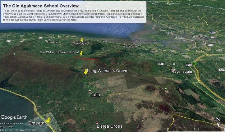
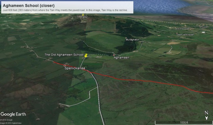
Aghameen School is located on the Cooley Peninsula, County Louth, shown in the following Google Earth Image

Schoolhouse Ruin Overview from Omeath– CLICK ME!!!!

This is the exact location:
Latitude 54° 2’17.83″N
Longitude 6°16’3.08″W

To get there go to the cross-roads in Omeath and drive uphill for a few miles to a T-junction. Turn left and go through the Windy Gap past the Long Woman’s Grave (shown on the following Google Earth image). Take the right fork at the next Y intersection. Continue for 1.4 mile (2.26 kilometers) to a Y intersection, take the right fork. Continue .18 mile (.28 kilometer) to find the ruin is on your right.

Aghameen Schoolhouse Location– CLICK ME!!!!

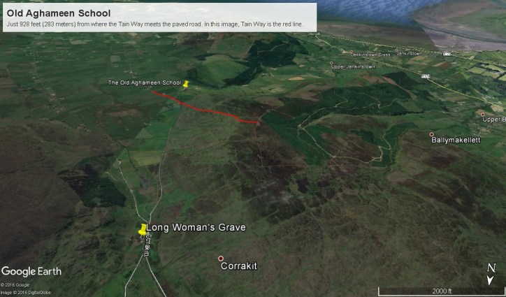
I marked the a portion of the Tain Way with a red line where it passes near the Old Schoolhouse.

Aghameen Schoolhouse Location closer– CLICK ME!!!!

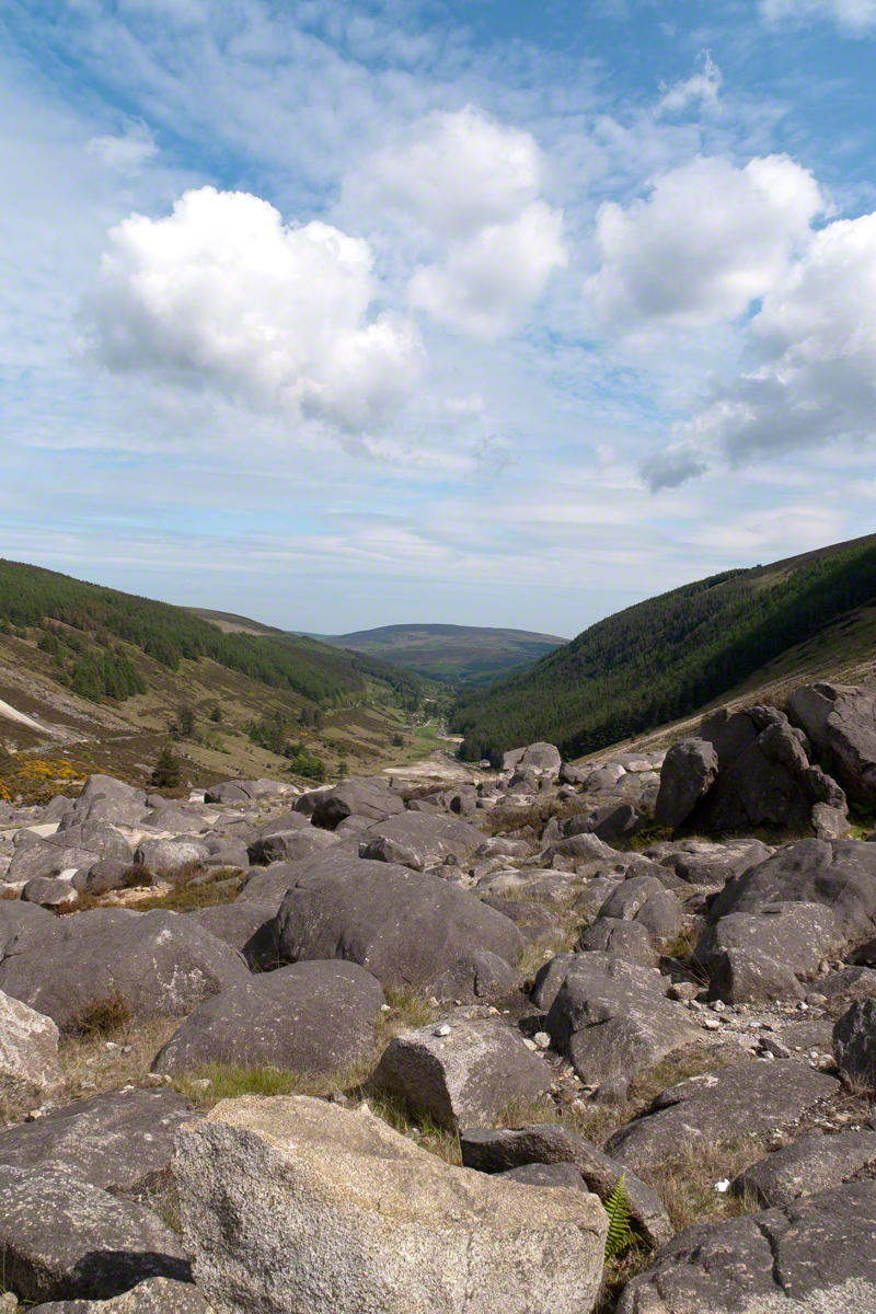
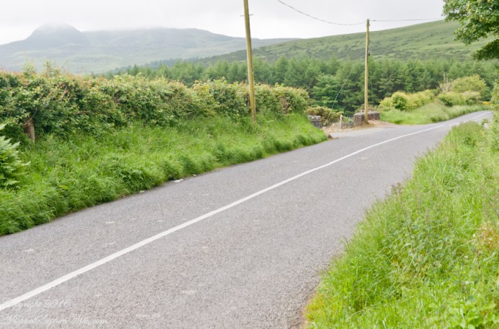
This is the road as viewed from the ruin looking south…..

Schoolhouse Ruin stone fence– CLICK ME!!!!

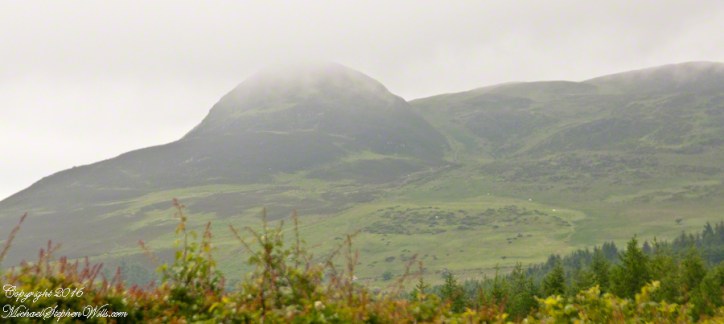
….and the distant view of the uniquely shaped peak Slievenaglogh to the southeast. Slievenaglogh in Irish is Sliabh na gCloch and means mountain of rocks. There is an identically named peak in the Mourne Mountains, to the north across Carlingford Loch. Slievenaglogh of Cooley Peninsula is an interesting element of south view from this valley.
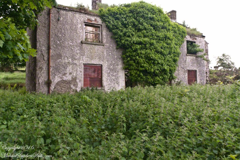
Schoolhouse Ruin stone fence– CLICK ME!!!!

The ruin itself. Schoolhouse Ruin stone fence– CLICK ME!!!!

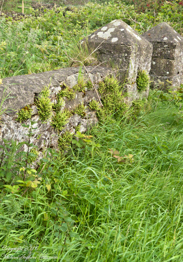
…behind a stone fence and gate posts.

Schoolhouse Ruin stone fence– CLICK ME!!!!

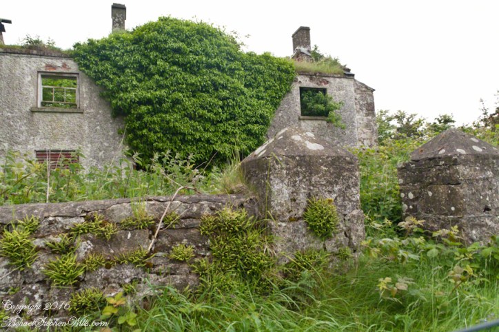
Overgrown with ferns, moss, grass…..

Schoolhouse Ruin stone fence– CLICK ME!!!!

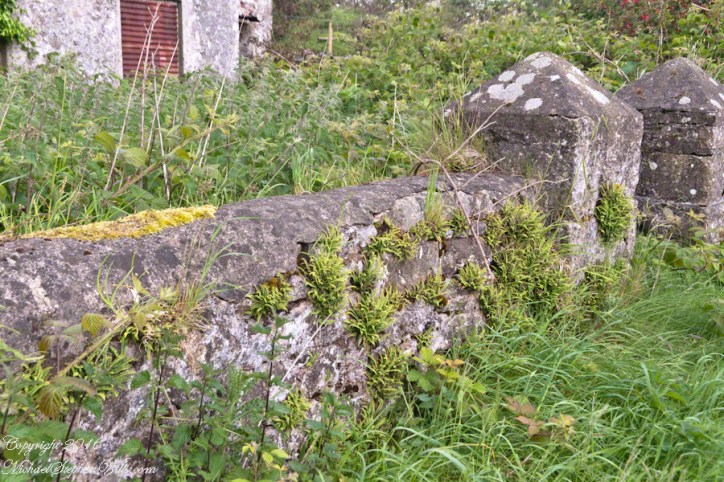
…the ever present lichen.

Schoolhouse Ruin stone fence– CLICK ME!!!!

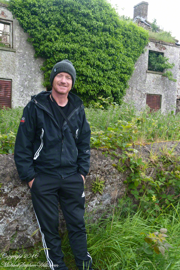
John’s son, Sean Mills, was with us.  That day, Sean lead us on Tain Way over the Golyin Pass over Slieve Foy with Carlingford as the destination.  Indeed, the Tain Way passes a few feet from this spot, being a loop of the Cooley peninsula. The Way is a two day walk, our starting point was a few miles from the schoolhouse.

Click for the previous posting in this series, “Happy Saint Patrick’s Day 2017”.

Click for the next posting in this series, “Annie Moore and her brothers”.Click for the next posting in this series, “Annie Moore and her brothers”.

Schoolhouse Ruin stone fence– CLICK ME!!!!

Glendalough View near Turlough Hill

An exceptional vista on a May afternoon

Head west from the Monastic City at the foot of the valley, climb pass the waterfalls to reach this east facing viewpoint.

I am standing near the path pilgrims from the west of Ireland travelled to the Glendalough holy sites.

Also, at my feet are “sun stones” a white quartz used by the builders of the Newgrange monument of the Boyne River Valley.

Click the link for my online gallery of Irish theme.
Click link for another Ireland Story “On the Tain Way.”

Copyright 2021 Michael Stephen Wills

Ice Bells

Noticing small miracles, taking the time and effort to capture them…..

These icicles were formed along Fall Creek during the coldest months of February in the Finger Lakes Region of New York State.

The transient nature of these forms is suggested by the thinness of the pedicle joining each bell to the ice lobe of the ledge. Note the golden crystals in the ice lobe.

A visualization of the symbolic power of the numeral three, reflected on itself.  Question: what do “threes” mean to you?

Captured with the Sony DSLR-A700, DT 16-105mm F3.5-5.6 lens, hoya circular polarizing filter, mounted on the Manfrotto tripod with ball head.

Click the photograph for my online gallery Ice Bells listing.

Inisheer Welcomes the 2014 Gaeltacht Irish Football champions

Inisheer Welcomes Their Champions

After we passed the Killeany bouy on our ferry trip, on the Queen of Aran, (click the link to see this posting) from the harbor of Inis Mor to Doolin, the ship made four, yes four, dockings before arriving at Doolin: three on Inis Meáin and one on Inisheer.

A few days prior the Gaeltacht held the annual Irish football championship the weekend of May 21 through June 1 in Moycullen, County Galway. It was the Three Aran Islands (Oileaín Árann) team who won the 2014 championship. Sunday, June 1, the weekend of their victory, the cup was presented to Inis Mór, the largest Aran island and the one furthest into Galway Bay.

Click the link for my Getty IStock photography of the Aran Islands

The team on Monday, June 2, the day of our trip, was on Inis Meáin, in celebration mode.  Some of them were waiting for the ferry when we pulled into the dock of Inis Meáin, the second largest Aran island between the other two.

The first of the previous three photographs is of the waiting team members who boarded and we left for Inisheer Island, the smallest of the three and the closest to Galway City.  The Queen of Aran was well out of the harbor when I imagine the radio in the pilot house said, “Come back, there are more team members on the dock.”  So we turned around, docked and several more came on board.

In way once again, well away from the harbor, the ferry turned around for a second time for a third landing at the  Inis Meáin dock.  With the full compliment of champions on board the ferry turned out of the harbor a third and final time for the last leg of with Silver Cup’s tour of the islands.

The population of Inisheer is about 250 souls.  It seemed all were waiting to greet the team.

Click the link for my Getty IStock photography of the Aran Islands

A large bon fire blazed as the Queen of Aran approached.

People lined the dock from beginning to end.

Calling out, waving their arms.

Click the link for my Getty IStock photography of the Aran Islands

Standing and smiling.  Here is a flock of fans, from Galway apparently, very pleased at the sight.

The team was on the upper ferry deck.  I turned around and was lucky enough to capture the team captain (Not sure, but who else would it be?) holding the silver cup for all to admire.  Theirs for a year.

The crowd welcomed their own back home.

Click the link for my Getty IStock photography of the Aran Islands

Surrounded the team and walked them grandly to town.

Enter your email to receive notification of future postings. I will not sell or share your email address.

Late Autumn Ithaca 8

A Dangerous Game

Hard on the Ithaca City Cemetery is our version of the crookedest street. Cascadilla Park road ascends East Hill as a series of switchbacks, charming homes cut into the hillside. A foot path overlooks the gorge, seen here.

Today, two young teens used the hill bottom for skateboarding. Taking turns on watch, each sped onto intersecting University Avenue. A dangerous game.

A brass plaque commemorates Daniel D Tompkins on eponymous Tompkins County courthouse. When the county was formed, 1817, Daniel Tompkins was a former governor of New York and Vice President to James Monroe. Tompkins never visited “his” county, there is no other connection between him. His family and life was rooted in eastern part of New York, around “The City.”

“Maternidad”, Seneca Street Garage, a mural by Nick Gilbert was the 2014 winner of 2014 @culturaithaca Latinx Mural Design Contest.

Mosaic Mural “Feels Like Ithaca” by Annamarie Zwack, Seneca Street Garage Also known as “Spirit of Ithaca”

I am not finding the attribution for this undersea idyll, also on the Seneca Street garage adjoining “Feels Like Ithaca.”

This completes my Sunday afternoon walk around Ithaca.

Copyright 2021 Michael Stephen Wills All Rights Reserved

Late Autumn Ithaca 7

Hillside Rest

We pick up this walk through Ithaca from the December 23rd post, next to a waterfall and the “Theory Center,” starting with the spiffed up rear façade of the Cornell Health Building, renamed from Gannett Health after a right wing newspaper publishing magnate. The building fronts “Ho Plaza” thus carries an address with unfortunate allusions, named for a distinguished Cornell alumna who’s family name is Ho. I included this building in appreciation to Cornell University and students for being good neighbors during this COVID-19 pandemic, controlling the virus.

Today, I avoided the views of the popular Lib Hill to minimize personal contact. Instead, descending the hill on footpaths, found myself on Stewart Avenue and the eastern side of City Cemetery.

Enjoying the solitude and long shadows of our northern afteroon.

Traversed a gate of hemlock branches….

Admired random monuments. By the way, George Washington Schuyler, whose family anecdote I shared in a previous post, rests here under an impressive stone. Not this one.

More afternoon light, fallen leaves, hemlocks.

Copyright 2021 Michael Stephen Wills All Rights Reserved

Late Autumn Ithaca 5

Golden Hour and “Happy New Year”

Walking the Lower Cascadilla Gorge Trail from the end of Court Street, downtown Ithaca, named for the Tompkins County Court is a favorite way for students to walk from the Cornell Campus.

I avoided the route today, the trail is narrow, much less than the 6 foot minimum distance. The footpath from Eddy Gate to College Avenue passes where the trail climbs up from the gorge. I did opt to catch the Upper Cascadilla Gorge trail, much wider. The trail passes two footbridges accessing the Engineering Quadrangle and the main Cornell Campus. Photographed here is the approach to the second, smaller, footbridge.

Late fall/winter afternoons the “Golden Hour” is hours long for this view of the footbridge and waterfall.

Waterfall views from the bridge. I left the tripod at home, so these exposures “freeze” water motion.

Look up from the other side for this view. Baptized 1985 as “The Theory Center,” 2007 saw the name changed to the more evocative, “Center for Advanced Computing.” It always filled with supercomputers. Socially, the culture of the place was retrograde from the beginning with “faculty only” lounges that kept out the lowly staff members. As if on cue, I came upon a group of the privileged, unmasked, strutting down the hill toward me, like vacuous moles.

Copyright 2021 Michael Stephen Wills All Rights Reserved

Late Autumn Ithaca 4

Past Eddy Gate

At this point most of the climb from downtown Ithaca is behind me and the Cornell Campus is underfoot. I pass the Eddy Gate, the former main entrance to Cornell University, where Eddy Street vaporizes to become a footpath along the rim of Cascadilla Gorge. This ramshackle hexagonal structure rest on the friable shale gorge rim. It does NOT look inviting and, over the years, I’ve not spotted a single person hanging out there.

Fluffy gone-to-seed goldenrod on the gorge rim.

As I duck into the Upper Cascadilla Gorge Trail above College Avenue a poster visualizes an effective defense against crowd control munitions, the umbrella. Below the call to “Stand with Hong Kong” is another newsflash/movie review from outside the mainstream media, “Donnie Darko Makes No Sense.”

Copyright 2020 Michael Stephen Wills All Rights Reserved

Late Autumn Ithaca 3

Up East Hill

Today a large fox devoured a squirrel on our front lawn while I wrote this post. Further up Green Street is this mural, I do not find an attribution and assume it is from 2020.

Continuing past all the new development in downtown Ithaca, I head up the steep sidewalk up east hill on Seneca Street, named for the Iroquois Confederacy tribe of the westernmost lands. Here is a flowering tree with attractive red haws growing on the corner of Seneca Street and Schuyler Place.

From the doorway of the former Henry W. Sage mansion at 603 E. Seneca St designed by William Henry Miller in1876. Today, it is broken into six apartments. This is the Sage of Cornell University Sage Chapel. Henry Sage was a supporter of admitting women to Cornell to the extent of donating $250,000 around the year 1870.

206 North Quarry Street, the northwest corner of Seneca and Quarry. It, too, once a single family home now broken into apartments.

Copyright 2020 Michael Stephen Wills All Rights Reserved

Late Autumn Ithaca 2

A family story and artistic expression

Across the street from Tompkins County Public Library, next to City Hall, is the Green Street Garage decorated with artistic graffiti by the French artist Amir Roti.

Completed during Fall 2012. This artist’s style is seen around town, black and white with touches of blue of inscrutable, dream inspired (?) scenes. The winters winds do whip through these streets.

A few steps away, some propaganda. I recognize the characters as Native Americans from the feather object. Doing some research I found it was completed in 2014 by Brandon Lazore here is some text from the artist, “”Women’s Nomination” is dedicated to all Haudenosaunee women. A silhouette of “Sky Woman” falls from Sky World. In moments, she will be caught by flying geese & put on turtle’s back – “Turtle Island.” In her hands she holds roots of the 3 sisters – corn, beans, & squash. The woman in green represents Clan Mother, grandmother, elder. The woman in purple is her daughter & the baby is her daughter’s daughter. The wampum belt is the Women’s Nomination Belt which represents, among other things, the right that Haudenosaunee woman have to give their child a clan, to chose names of children, & to choose chiefs. Strawberries represent medicine like mother’s love is medicine to a child. The moon represents fertility & how it’s cycle plays a huge role in every woman’s life. The Sky Domes are inspired by traditional art decorating our clothing for centuries. It represents the sky world & the plants that were given to us – corn, beans, squash, & tobacco.” Haudenosaunee are also known as Iroquois.

To counterbalance the sentimentality of the mural here is historical context, a family anecdote from George Washington Schuyler of Ithaca, New York from the life of his paternal ancestor, Peter Schuyler, known to the Mohawks as “Quidor,” as told to the author, John Fisk, in 1881. “After a severe tramp in the wilderness, half starved with hunger and cold, Quidor came on evening upon an encampment of Mohawks, where he was cordially welcomed. In a few moment he was seated before a bright blaze, with a calabash of hot soup, the most delicious he had ever tasted. Presently, when he dipped his rude ladle once more into the kettle and brought up a couple of parboiled human fingers, it gave him a queer turn, but he repressed all show of feeling and quietly asked a feathered chieftain, ‘What is this soup made of?’ The chief as calmly replied, ‘Of a Frenchman we killed this morning; isn’t it good?'” Words even more significant because I would soon walk past the grave of George Washington Schuyler, laid to rest 132 years ago.

References:

The Dutch and Quaker Colonies, Volume II, by John Fisk, The Riverside Press, Cambridge, 1899, p214 “Peter Schuyler and his influence over the Mohawks”.

The 2019 Ithaca Mural Map

Copyright 2020 Michael Stephen Wills All Rights Reserved