Very Old, Very New

Lima is home to 10 million Peruvians and over 1000 historical sites.

View of Clinica Delgado (hospital) from Lima Peru’s Elias Aguirre (street), Huaca Pucllana filling the foreground. Huacas are commonly located in nearly all regions of Peru outside the deepest parts of the Amazon basin in correlation with the regions populated by the pre-Inca and Inca early civilizations. They can be found in downtown Lima today in almost every district, the city having been built around them. Huaca Pucllana, located in Miraflores district, is an adobe and clay pyramid built from seven staggered platforms. It served as an important ceremonial and administrative center for the advancement of the Lima Culture, a society which developed in the Peruvian Central Coast between the years of 200 AD and 700 AD. 

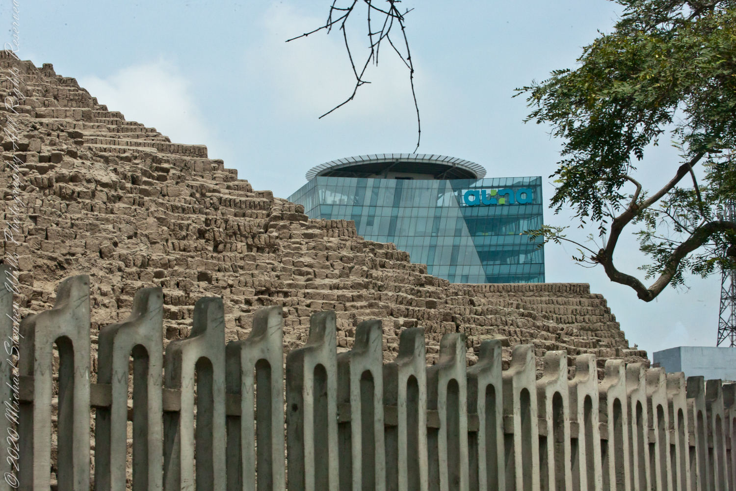
This is the New York Times article that inspired me to remember visiting Huaca Pucllana during our February 2016 tour of Lima, Peru. “3,000 Years of History Are Literally Just Beneath Our Feet.”

Copyright 2022 Michael Stephen Wills All Rights Reserved

Torr Head Stories II

Ancient Castles and Raithlin Island

Knights of the Red Branch appear towards the end of “Deirdre and the sons of Uisneach”, a tale from 1st century AD Ireland, as protectors of the lovers Dierdre and one of the sons of Uisneach, named Naoise. The two fled to Rathlin Island, seen in the distance in the following photograph.

From Rathlin Island they passed over the Irish Sea to Scotland where they lived happily for a term of years.

Click me for an earlier Torr Head post “A Bit About Torr Head.”

Barrach’s fort no longer exists, a Coast Guard Station was built over the site. There are other intact ruins on this picturesque coast. Here is one close to the Giant’s Causeway, Dunseverick Castle.

Copyright 2022 All Rights Reserved Michael Stephen Wills

World at our Feet

On Peter’s Mesa

View North / Northwest from Peter’s Mesa. At our feet is a mature Saguaro Cactus towering over Charlebois Canyon, to the right Black Mountain. Bluff Spring Mountain, middle distance, then Black Top Mesa. Flatiron Peak, of the famed Superstition Mountain, is in distance. Photographed from Peter’s Trail on a March afternoon 2008. Superstition Wilderness, Tonto National Forest, Arizona

Bluff Spring Mountain, middle distance, then Black Top Mesa. Flatiron Peak, of the famed Superstition Mountain, is in distance. Photographed from Peter’s Trail on a March afternoon 2008. Superstition Wilderness, Tonto National Forest, Arizona

Click Me for the first post of this series, “Bluff Spring Mountain.

Copyright 2022 Michael Stephen Wills All Rights Reserved

Torr Head Stories I

Mysterious Barrach, Knight of the Red Branch

Torr in Irish is a steep rocky height. Likewise, Corr means odd, uneven, rounder, convex, curved, peaked, projecting, smooth. Combined Torcorr is the townland where we stopped on the Torr Road, halted by our wonder at this sight.

In the distance, Torr Head projects into North Channel, the closest land to Scotland. Following the coast, the cliffs in front of Torr Head are home to numerous sea birds such as Fulmars (family Procellariidae) nad Oystercatchers (family Haematopodiadae). Along the rock beaches next Eider Ducks (genus Somateria). You might see the Common Buzzard (species Buto buteo).

Click photograph for a larger view. To do this from WordPress Reader, you need to first click the title of this post to open a new page.

Click me for an earlier Torr Head post “A Bit About Torr Head.”

In the following photograph Torr Head seen from immediately above. I stand on the ancient site of Barrach’s fort, a knight of the Red Branch. After some internet research I cannot find another reference to this knight, other than the information placard on Torr Head.

Morning / Evening

Can you see the Needle’s Eye?

The eye of Miner’s Needle is clear in both these South / Southeast views from Peter’s Mesa looking across the Music Canyon.

Many wildflowers, sprinkled like stars through the foreground of the morning photograph with Prickly Pear, Cholla and Saguaro cactus. Beware of “Jumping Cholla”, named for its seeming ability to attack passers-by. Another name, “Hanging Chain Cholla”, is more appropriate. Each chain with many hooked barbs is lightly attached to the branch, ready to snag a ride from unwary hikers.

Light rakes across the landscape in the evening photograph, taken from another vantage point on Peter’s Mesa. Miner’s Needle is four (4) miles away “as the crow flies,” i.e., line of sight distance.

Click Me for the first post of this series, “Black Mountain.

Copyright 2022 Michael Stephen Wills All Rights Reserved

A Bit About Coolranny Townland

Neat and tidy

2014, the count of townlands on and around the island of Ireland was 61,098 with most of Irish Gaelic origin predating the Norman invasion, first recorded in 12 century church records. The names have a pride of place reflected in the beauty of the namestones along Torr Road.

Click photograph for a larger view. To do this from WordPress Reader, you need to first click the title of this post to open a new page.

The 82 acres of Coolranny forms a slice of land running from a ridge to Loughan Bay off the North Channel of the Irish Sea across from Scotland.

See this post for a description of wildflowers flowering here in the month of June.

A spic and span cottage on Torr Road, maybe the rectory for the Saint Mary’s Star of the Sea church.

An informative placard.

Here is a slideshow of this post’s images. To visit from WordPress Reader, you need to first click the title of this post to open a new page.
Copyright 2022 All Rights Reserved Michael Stephen Wills

Panoramic

Superstition Glory

View North / Northwest from Peter’s Trail looking back the way we came. Black Mountain on right, Bluff Spring Mountain left with LaBarge Canyon running to the Red Hills center. On a March afternoon 2008.

Click Me for the first post of this series, “Black Mountain.

Copyright 2022 Michael Stephen Wills All Rights Reserved

Hear the Music

Roasted Yucca

Here we are climbing Peters Trail to the eponymous mesa and facing East to Music Mountain. Scattered in the brush are desiccated and live Prickly Pear cactus. Poles of young saguaro cactus like randomly placed telephone poles poke up around the lower slopes.

The first published record of Music Mountain is by Ray C. Howland of Mesa Arizona who sent a letter to “Everybody’s Magazine” that appeared in a feature called “Everybody’s Meeting Place: Where writers, readers and the editor gather for informal discussion,” May 1928, Volume 58, Issue 5, page 173. I reproduce Howland’s letter here with minor editing:

“I am in the deserts and mountains of Arizona most of the time. I go into town once each month for mail and provisions. I meet many things as I ramble around, many strange things, things that are beyond my ability to comprehend. One particular was in my mind as I read your printed thought in the back of Everybody’s. Far in the Superstition Mountains of Arizona, in the deepest, most rugged canyon, there are three caves halfway up a great yellow bluff. In these caves are mud dwellings. There are not the cliff-dwelling as found in other parts of Arizona.

The mud walls of these dwellings were made by people with very small hands. The handprints of these ancient masons remain as though they were made yesterday. Just below these caves a beautiful pool of crystal-clear water lies between grassy banks. Tall ghostlike sycamores grow there in great numbers.
I have camped many times beneath those sycamores. It is a beautiful spot. Such a difference between there and the hot desert that lies fifteen miles to the south.! As one lies there, just at twilight, begins the most wonderful music one could imagine. I have never heard music that could compare to it, vague, elusive at times, then again of greater volume. It is my opinion that no living being could record it.

The music is, I believe, beyond description. It seems to take you out of your moral self and transport you back ages and ages, almost to the beginning of things. For the time being one feels as though he were in another world.
I have often tried to solve this little private mystery. I can’t explain it. I can’t even describe it intelligently.

You will probably say as you read this that is is the wind among the pinnacles, caves, trees, etc. that make this wonder phenomenon. It cannot be, for usually there is no breeze in the mountains at twilight. It is still as a tomb except for that music. Besides when the breeze is blowing at any other hours of the day there is no sound.”

Here is a copy of that issue for you to see for yourselves.

In my photographs the bluffs described by Howland are seen clearly in the distance. During our expedition we were never able to visit the caves, though Dave described the location, caves, and dwellings. On Peter’s Mesa are remains of pits where Apaches and Yavapais gathered hearts of agave to roast. We visited a small cave in the side of Peter’s Mesa showing signs of high heat and possibly used for roasting agave.

Click Me for the first post of this series, “Black Mountain.

Copyright 2022 Michael Stephen Wills All Rights Reserved

From Music Canyon

Down South

Dutchman Trail follows the outflow of two springs along the canyon floor: Music Canyon and LaBarge springs. Here we are climbing Peters Trail to the eponymous mesa and facing south / Southeast, looking down on Dutchman Trail.

This is rough country below Bluff Spring Mountain. Stag Horn Cholla cactus is lower right with Prickly Pear cactus scattered in the brush. Poles of young saguaro cactus are scattered around the lower slopes.

Click Me for the first post of this series, “Bluff Spring Mountain.

Copyright 2022 Michael Stephen Wills All Rights Reserved

Torr Head Wildflower Meadow

can you see any other flowers/plans in this photograph? Please leave a comment if you do.

We parked below the Coast Guard station, headed toward the height of Torr Head. I was stopped in my tracks by the hillside meadow wildflower profusion. 

Here are a few I identified, listed by common name: Bluebell, Daisy, Meadow Buttercup, Sea Campion, Yarrow.  We love daisies and buttercups around home.  We spotted Sea Campion on the Dingle Peninsula, as well.  Yarrow is common through Ireland.  I don’t recall seeing bluebells anywhere else. 

It was the bluebells in this photograph that clued me into why I took a photograph of the hillside.  The view north takes in coastal sheep pasture looking on a portion of North Channel and the Irish island Rathelin.

The web page I used for identification was wildflowersofireland.net . Great information and links to the Botanical Society of Britain and Ireland with a distribution map.

Copyright 2022 All Rights Reserved Michael Stephen Wills