Carved by Time: Exploring the Virgin River and Cross-Bedded Sandstone in Zion’s Narrows

A quiet moment along the Virgin River reveals the artistry of nature—where water, stone, and time shape Zion’s majestic Narrows in subtle, surprising ways.

In Zion National Park, where towering sandstone cliffs rise from the desert floor, the Virgin River weaves a persistent and graceful thread through deep canyons carved over millennia. The river is the creative force behind Zion’s signature landscape, sculpting stone with a patient hand. Among its greatest achievements is the Narrows—a sinuous gorge where water and light perform a timeless duet. The two photographs shown here draw us into an intimate corner of that realm, where water flows past a rock face marked by both subtlety and drama.

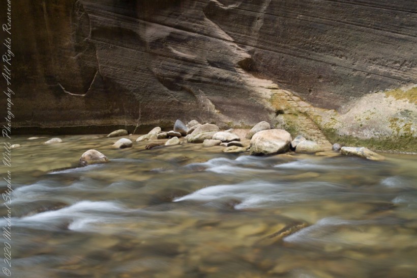
At first glance, what stands out is the unusual structure on the wall behind the river—a feature that at a distance could easily be mistaken for a man-made stairway. But closer observation reveals this to be a natural element, the result of erosion acting upon cross-bedded Navajo Sandstone. The texture and linearity of these formations are remnants of ancient sand dunes hardened into rock nearly 190 million years ago, during the Jurassic period. What looks like precision carving is, in fact, the legacy of sedimentation, lithification, and the scouring action of water over time.

In the first photograph, the scene is bathed in soft, diffused light, lending a quiet tone to the flowing water and the weathered rock face. The surface of the Virgin River becomes a silky sheet, its motion captured with long exposure so that it seems to glide effortlessly past the cluster of smooth stones in the foreground. Here is a deep calm—the kind that can be heard in the hush of water over stone and felt in the breathless silence of a canyon morning.

Click each photo for a larger view

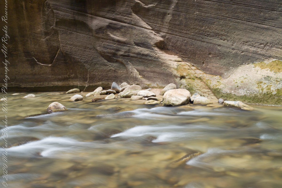
The second photograph, taken under brighter conditions, reveals the same scene with different character. The increase in light clarifies the water’s transparency, the greens of moss and lichen on the wall, and the golden tones of the sandstone. What you see is a pattern formed by layers of wind-blown sand, once part of vast dunes, now standing as a stone ledger of time. The river, its bed visible beneath the shallow flow, seems to read this text as it passes—century by century, pebble by pebble.

The Virgin River begins high in Southwestern Utah, at the Navajo Reservoir in the Dixie National Forest north of Zion National Park and travels over 160 miles to join the Colorado River, carving through layers of sedimentary rock as it descends. In the Narrows, the canyon walls rise up to a thousand feet while the corridor narrows to just 20–30 feet across in places. The intimacy of the Narrows contrasts with the vast openness elsewhere in Zion, enclosing the traveler in a world of water and stone, shadow and echo.

Walking the Narrows means walking in the river itself—an experience that engages body and spirit alike. The water is rarely still, and neither is the trail. Slippery rocks and ever-shifting current demand attention and balance. Yet, this very immersion invites a deeper kind of awareness. You are observing nature from within it, shaped by nature, and held by nature.

What the photos capture so eloquently is that Zion is a place where the work of nature can appear deliberate, even architectural. The illusion of stairways in the sandstone, carved not by hands but by wind, gravity, and time, is a reminder of how little separates the human sense of design from the forms nature produces. We recognize rhythm and repetition, elevation and flow, and are drawn to interpret meaning from these patterns.

But perhaps the meaning lies not in what we impose, but in what we receive. The Virgin River’s passage through this sculpted corridor teaches patience, resilience, and the beauty of gradual transformation. Its waters do not fight the rock; they yield, swirl, and persist—until the rock, by degrees, gives way. What results is a landscape both eternal and ever-changing.

Zion’s grandeur is easy to admire its many amazing overlooks, but its soul is found in quiet places like this—where sandstone walls, smoothed by water and time, speak not in shouts but in whispers. Here, beside a seeming stairway that leads nowhere and everywhere, we come face to face with the artistry of the Earth.

Enter your email to receive notification of future postings. I will not sell or share your email address.

White House Ruin

In 2003 and 2008, the author visited and photographed White House Ruin in Canyon de Chelly, observing changes in landscape.

In November 2003, my son Sean and I journeyed up Route 191 from Petrified Forest National Park, arriving in Chinle on a crisp autumn afternoon. My photography equipment at the time was modest: a Sony Point and Shoot 5 MP camera with filters, a purse-like over-the-shoulder bag, and a basic tripod from Kmart.

We reached the White House trailhead in Canyon de Chelly and began our hike. The trail was quiet, and as the sun set at 5:20 pm, we found ourselves virtually alone. A dense growth of Russian Olive trees dominated the wash at that time. In the dimming light, I captured a distant shot of the White House Ruin, whitewashed, set against the backdrop of autumn-hued Russian Olive foliage. Nearby, a grove of Cottonwoods, still green, stood near the canyon wall.

By the time Pam and I returned in July 2008, four years and nine months later, the landscape had changed. The invasive Russian Olives had been removed, and the White House Ruin was no longer painted white.

The same Route 191 that Sean and I had taken in 2003 led us through the Four Corners region of Northern Arizona. Pam and I had traveled from Colorado, arriving in the late afternoon. This time, the Navajo Reservation’s adherence to daylight savings time meant the sun wouldn’t set until 8:33 pm. My aim was to photograph the White House Ruin that I had missed years earlier.

That July day the sun set 8:33 pm as the Navajo Reservation observes daylight savings time. My goal was to photograph the White House Ruin I missed in 2003. We arrived at the trail head. My photography kit was expanded from 2003, now included a Kodak DSC Pro slr/C, the “C” meaning “Canon” lens mounting, a Sony 700 alpha slr (I only use a variable lens), Manfrotto tripod with hydrostatic ball head, and the backpack style Lowe camera case. With the tripod it is over 25 pounds.

With this on my back I was prepared to boogie down the trail. At the height of tourist season there were many more people at the trailhead. Pam, being a friendly person, started a conversation while I ploughed ahead along the flat canyon rim. It is solid red sandstone, beautiful, generally level with enough unevenness to require attention. When Pam saw how far ahead I was she tried to catch up, tripped, fell hard.

I backtracked to Pam and we decided what to do. She thought, maybe, the fall broke a rib. We decided to proceed and descended, slowly, together. Here we are in front of the ruin. The sun, low in the sky, is moving below the south canyon wall. This is a perfect time, and I used both cameras.

The sweep of cliff and desert varnish was my intent to capture. Here it is through the Canon 50 mm lens.

Click link for this White House photograph in my Online gallery.

I captured this version with the Sony Alpha 700 slr, the variable lens set to widest angle.

Click link for this White House photograph from my online gallery.

Here the camera setup waits out the sun…..

Click Me to view my photographs on Getty.

Copyright 2023 Michael Stephen Wills All Rights Reserved http://www.MichaelStephenWills.com

One Early Spring Morning

High Water

Here is the third waterfall in the Fillmore Glen Gallery of Waterfalls, shaded by hemlocks, below bridge eight (8) on an early spring morning of high-water volume.

A high dynamic range rendering from several exposures from a Kodak DSC Pro SLR/c with a Canon EF 50 mm f/1.4 USM all mounted on a very stable Manfrotto 468MG tripod with Hydrostatic Ball Head.

Fillmore Glen State Park Moravia, Cayuga County, New York.

Click for my “Finger Lakes Memories” Fine Art Photography Gallery.

Copyright 2023 All Rights Reserved Michael Stephen Wills

A Change of Orientation

Portrait orientation expands the view

Portrait orientation of the waterfall beneath the dam reveals the length the water takes across a cliff face. A shattered Hemlock destroyed over previous winter is in foreground.

A high dynamic range rendering from several exposures from a Kodak DSC Pro SLR/c with a Canon EF 50 mm f/1.4 USM all mounted on a very stable Manfrotto 468MG tripod with Hydrostatic Ball Head.

Fillmore Glen State Park Moravia, Cayuga County, New York.

The high waterfall flowing from the outlet from the dam of Dry Creek on a spring morning just after the solstice. A shattered Hemlock destroyed over previous winter is in foregound. Fillmore Glen State Park, Moravia, Cayuga County, New York

Click for my “Finger Lakes Memories” Fine Art Photography Gallery.

Copyright 2023 All Rights Reserved Michael Stephen Wills

Beneath the Dam

A very wet “Dry Creek”

The upper portion of a high waterfall flowing from the outlet from the dam of Dry Creek on a spring morning just after the solstice.

A high dynamic range rendering from several exposures from a Kodak DSC Pro SLR/c with a Canon EF 50 mm f/1.4 USM all mounted on a very stable Manfrotto 468MG tripod with Hydrostatic Ball Head.

Fillmore Glen State Park Moravia, Cayuga County, New York.

Click for my “Finger Lakes Memories” Fine Art Photography Gallery.

Copyright 2023 All Rights Reserved Michael Stephen Wills

A Turkey Tail?

Bracket Fungus

Trametes versicolor – also known as Coriolus versicolor and Polyporus versicolor – is a common polypore mushroom found throughout the world.

Meaning ‘of several colors’, versicolor reliably describes this fungus that displays a variety of colors. For example, because its shape and multiple colors are similar to those of a wild turkey, T. versicolor is commonly called turkey tail.

Found on a rotting Hemlock stump, Fillmore Glen State Park Moravia, Cayuga County, New York.

Kodak DSC Pro SLR/c with a Canon EF 100 mm f/2.8 Macro USM lens stabilized on a Manfrotto 468MG tripod with Hydrostatic Ball Head

Polypores are a group of fungi that form large fruiting bodies with pores or tubes on the underside (see Delimitation for exceptions). They are a morphological group of basidiomycetes-like gilled mushrooms and hydnoid fungi, and not all polypores are closely related to each other.

Kodak DSC Pro SLR/c with a Canon EF 100 mm f/2.8 Macro USM lens stabilized on a Manfrotto 468MG tripod with Hydrostatic Ball Head

Polypores are also called bracket fungi or shelf fungi, and they characteristically produce woody, shelf- or bracket-shaped or occasionally circular fruiting bodies that are called conks.

Sony alpha 700, Sony Lens DT 18-200mm F3.5-6.3 stabilized on a Manfrotto 468MG tripod with Hydrostatic Ball Head

Most polypores inhabit tree trunks or branches consuming the wood, but some soil-inhabiting species form mycorrhiza with trees. Polypores and the related corticioid fungi are the most important agents of wood decay, playing a very significant role in nutrient cycling and aiding carbon dioxide absorption by forest ecosystems.

Sony DSC F828 stabilized on a Manfrotto 468MG tripod with Hydrostatic Ball Head

Sony DSC F828 stabilized on a Manfrotto 468MG tripod with Hydrostatic Ball Head

Sony DSC F828 stabilized on a Manfrotto 468MG tripod with Hydrostatic Ball Head
Reference: “Trametes versicolor” on Wikipedia

Click for my “Finger Lakes Memories” Fine Art Photography Gallery.

Copyright 2023 All Rights Reserved Michael Stephen Wills

Ice Abstracts

Light Plays

Surface of ice formed over a flowing creek. One is a HDR of three exposures, the other is a single exposure. Yes, that is dirt you see under the ice. How did that happen?

Readers: Can you tell which is the HDR? Please answer with a comment. Thank You

All are macros from a Kodak DSC Pro SLR/c with a Canon EF 100 mm f/2.8 Macro USM lens stabilized on a Manfrotto 468MG tripod with Hydrostatic Ball Head

Fillmore Glen State Park, Moravia, Cayuga County, New York.

Click for my “Finger Lakes Memories” Fine Art Photography Gallery.

Copyright 2023 All Rights Reserved Michael Stephen Wills

Revealed Form IV

Hoary Elm in HDR

Late Winter, on the cusp of Spring, I arrived at the Cornell Experimental farm before sunrise.  

There I set up a Kodak DSC Pro SLR/c with a Canon EF 50 mm f/1.4 USM lens all mounted on a very stable Manfrotto Studio Aluminum Tripod Model 475 and Hydrostatic Ball Head. From this 15 exposures were obtained. Photoshop CS6 HDR combined the 15 into this perfected image. Cornell Thompson Experimental Farm, Town of Dryden, Tompkins County, New York

Revealed Form III

On a late winter morning on the cusp of Spring 2007 I ventured from my home on Fall Creek on a photo expedition.  

Form here is revealed through the fine snowfall dusting the evergreen boughs of this stand of pines, not enough to stop the wind for which is tract of the Cornell Thompson Research Farm is known.

Gold Dust Found

Desert Riches

A few minutes after photographing this Stressed Mesquite I looked across the creek to the slope of volcanic rock fallen from the cliff of Black Top Mesa where clumps of dark yellow, in the following photograph of that cliff, mark clusters of flowering Mexican Poppies.

Mesquite, of the genus Prosopis, is a widespread, successful desert shrub that sometimes grows into a tree forms, as you see here. A mesquite tap root can extend 190 feet down to draw on the water table. East Boulder Creek was flowing, in this season, a few feet away. Still, this mesquite is stressed, with a loss of over half of its bark. Dutchman Trail between Black Top Mesa and Palamino Mountain, Superstition Wilderness, Tonto National Forest, Arizona

Click Me for my Online Gallery

Plentiful winter rains of 2008 trigged a profusion of Mexican Poppies throughout the Superstition Wilderness. Here is a photograph captured after our expedition.

Look carefully for a scattering of color, like gold dust, at the foot of the volcanic cliffs. That is spring blooms of Mexican Poppy (Eschscholtzia californica). This gold wonder is plentiful from the month of late February through April, varying with the rains.

Copyright 2022 Michael Stephen Wills All Rights Reserved