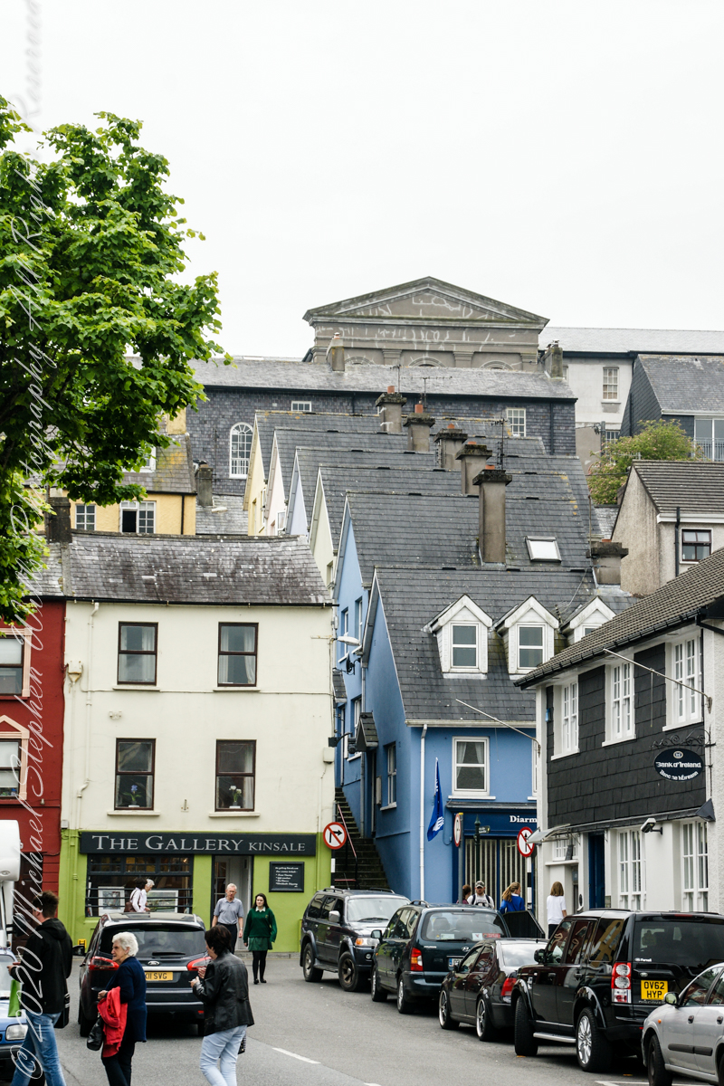
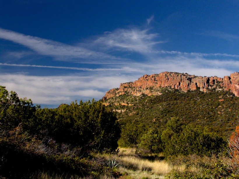
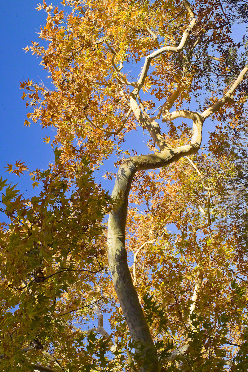
Kinsale, a historic seaport in County Cork, showcases unique architecture and geography, with its streets and houses built on steep inclines near the river Bandon.
The first of a series of idiosyncratic posts from a 2014 walking tour of Kinsale.
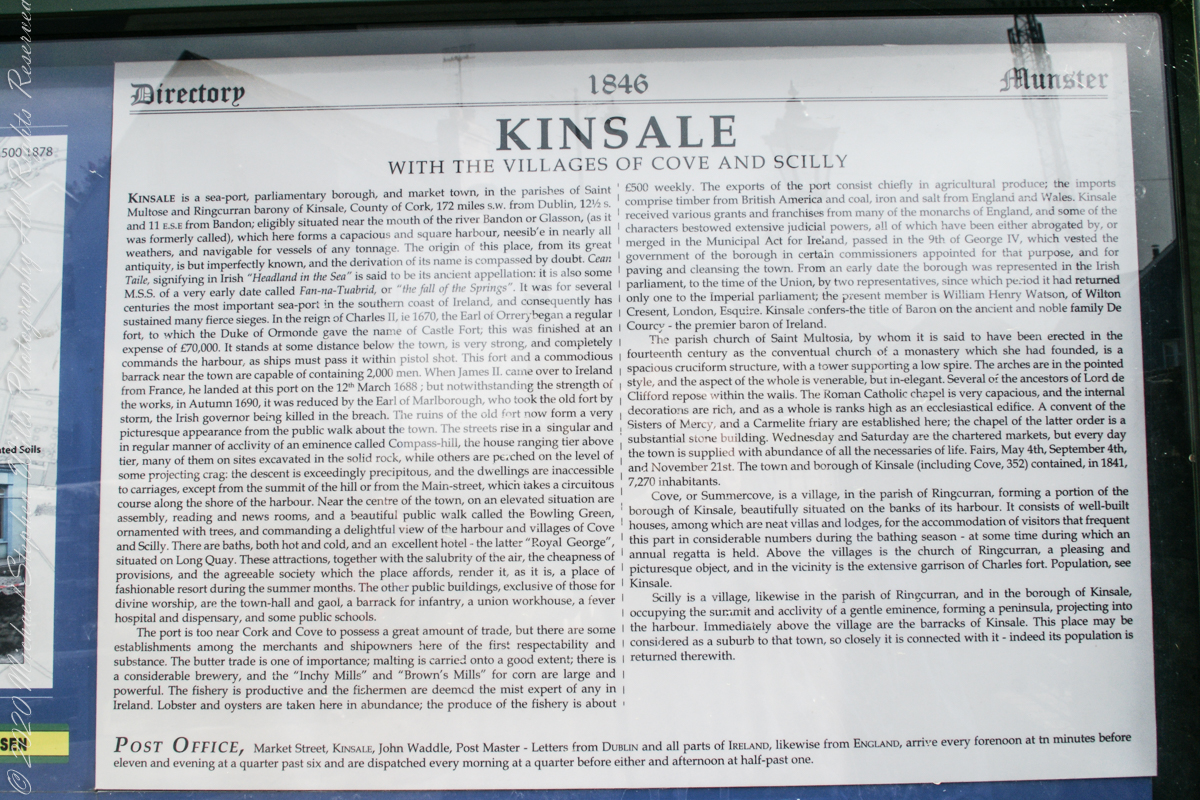
Text from an poster behind glass accessible to all and sundry. Directory 1846 Munster, Kinsale with the villages of Cove and Scilly. Kinsale is a seaport, parliamentary borough and market town in the parishes of Saint Multose and Ringcurran barony of Kinsale, County of Cork, 172 miles s.w. from Dublin, 121/2 s and 11 e.s.e. from Bandon; eligibly situated near the mouth of the river Bandon or Glasson, (as it was formerly called), which here forms a capacious and square harbor, accessible in nearly all weathers, and navigable for vessels of any tonnage. the origin of this place, from its great antiquity, is but imperfectly known, and the derivation of its name is compassed by doubt. Cean Taile (Cionn tSáile), signifying in Irish “Headland in the Sea” is said to be its ancient appellation. (see more in the photograph).
An informative poster behind glass accessible to all and sundry. Text: Directory 1846 Munster, Kinsale with the villiages of Cove and Scilly. Kindale is a sea-0ort, parlimentary borough and market town i the parishes of Saint Multose and Ringcurran barony of Kinsale, County of Cork, 172 miles s.w. from Dublin, 121/2 s and 11 e.s.e. from Bandon; elibibly situated near the mouth of the river Bandon or Glasson, (as it was formerly called), which here forms a capacious and square harbour, accessible in nearly all weathers, and navigable for vessels of any tonnage. the originn of this place, from its great antiquity, is but imperfectly known, and the derivaltion of its name is compassed by doubt. Cean Taile, signifying in Irish “Headland in the Sea” is said to be its anceient appellation. (see more in the photograph)./
Here we are on Emmet Place. There is a row of houses built along a steep alley named “The Stoney Steps.” At top is the aptly named Higher O’Connell Street.
The Gallery Kinsale
13 Main Street
Kinsale
West Cork
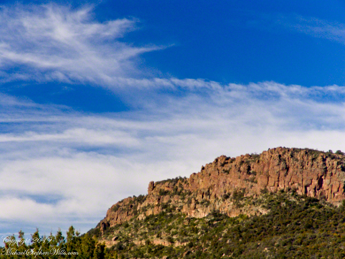
Ireland. From an informative poster…The streets rise in a singular and in regular manner of acclivity of an eminence called Compass Hill, the house ranging tier above tier, many of them on sites excavated in the solid rock, while other are perched on the level of some projecting crag: the descent is exceedingly precipitous, and the dwelling are inaccessible to carriages, except from the summit of the hill or from Main street, which takes a circuitous course along the shore of the harbor.
From the informative poster…The streets rise in a singular and in regular manner of acclivity of an eminence called Compass Hill, the house ranging tier above tier, many of them on sites excavated in the solid rock, while other are perched on the level of some projecting crag: the descent is exceedingly precipitous, and the dwelling are inaccessible to carriages, except from the summit of the hill or from Main street, which takes a circuitous course along the shore of the harbor.
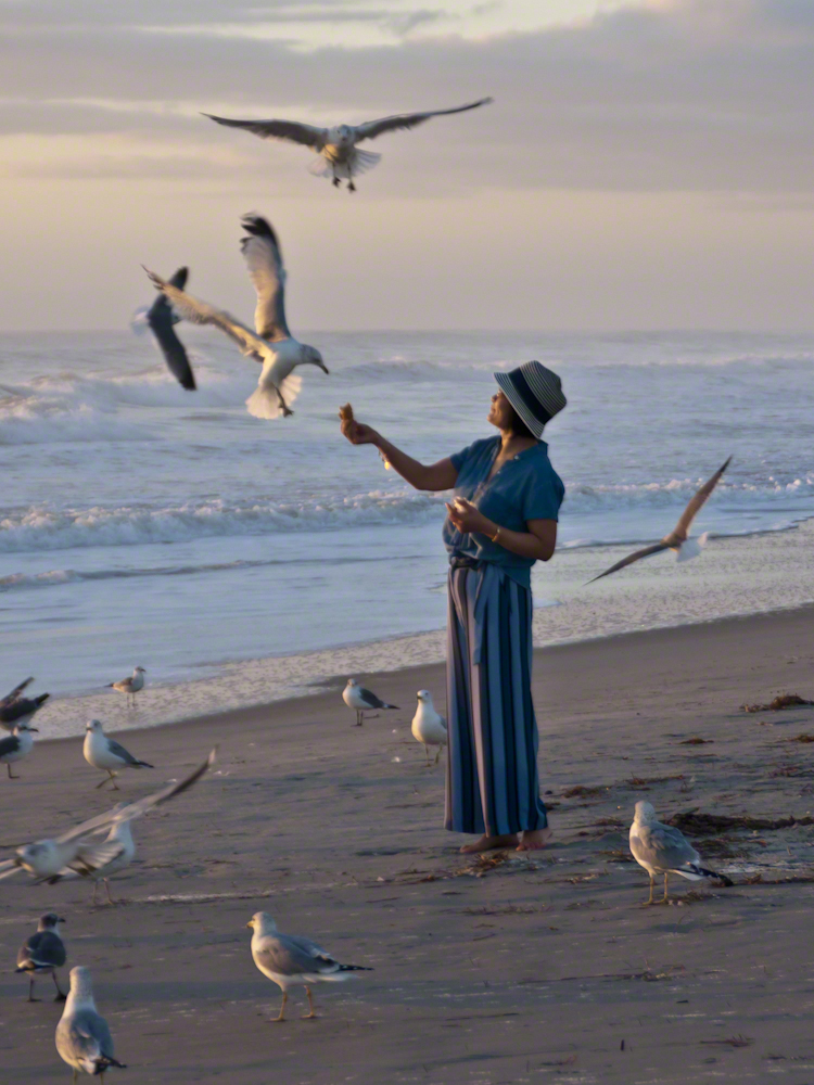
Gulls, an omnipresent element of any beach stroll. Pestiferous, abounding and incessant the gull is simple to deal with. Keep any and all foodstuffs under wraps.
Conversely, for those who adore a crowd of raucous opportunists simply pull out the food and offer it to the air. There is more about this photograph at this post, “Lady Feeding Gulls, Cocoa Beach Dawn.”
Click any photograph for a larger view.
Beach Walking
Pam and I developed a habit of hanging out in Florida during Finger Lakes Winters when the gorges are closed for safety and even walking the streets is perilous, stray black ice encounters abound. We trade icy falls for beach walks.
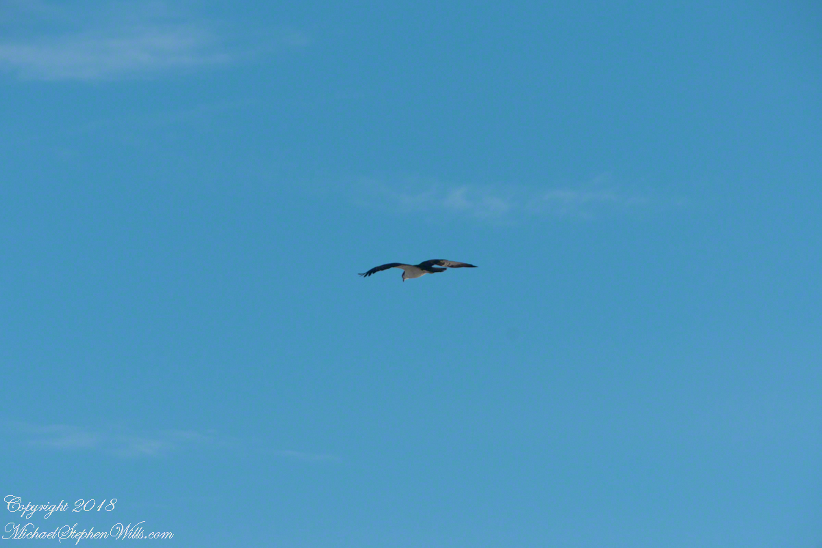
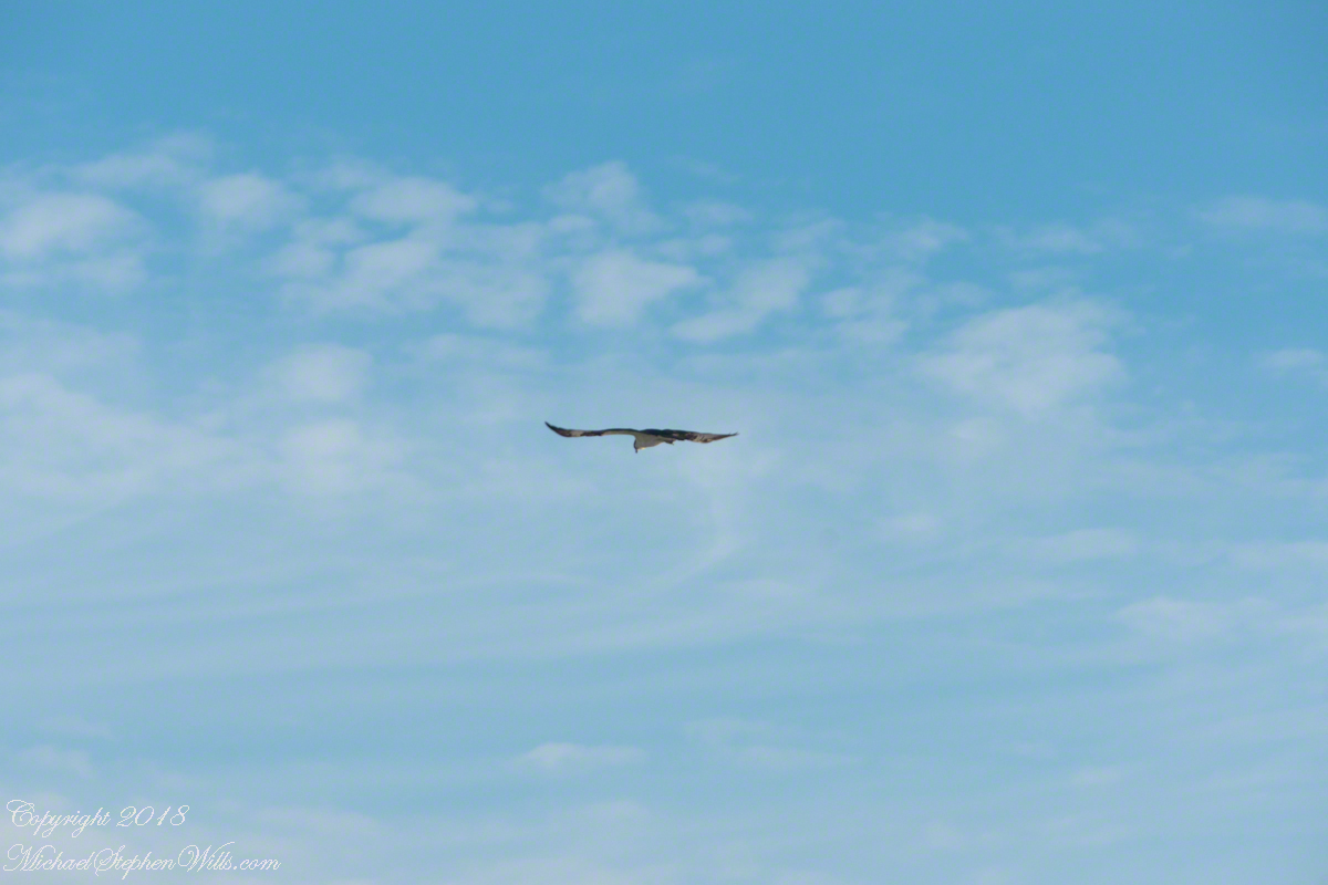
It is natural to become inured to the flight of gulls along the shore. For all my carting along the Sony Alpha 700 with a variable lens ( 18 – 200 mm) there is not a single photograph of a gull in flight. Yet, I have my eye on them until my blindness was lifted by a peculiar individual. It seemed to be a white gull, yet it had a watchful eye.
Gliding shoreline parallel with head down, how could I have mistaken it for a gull?
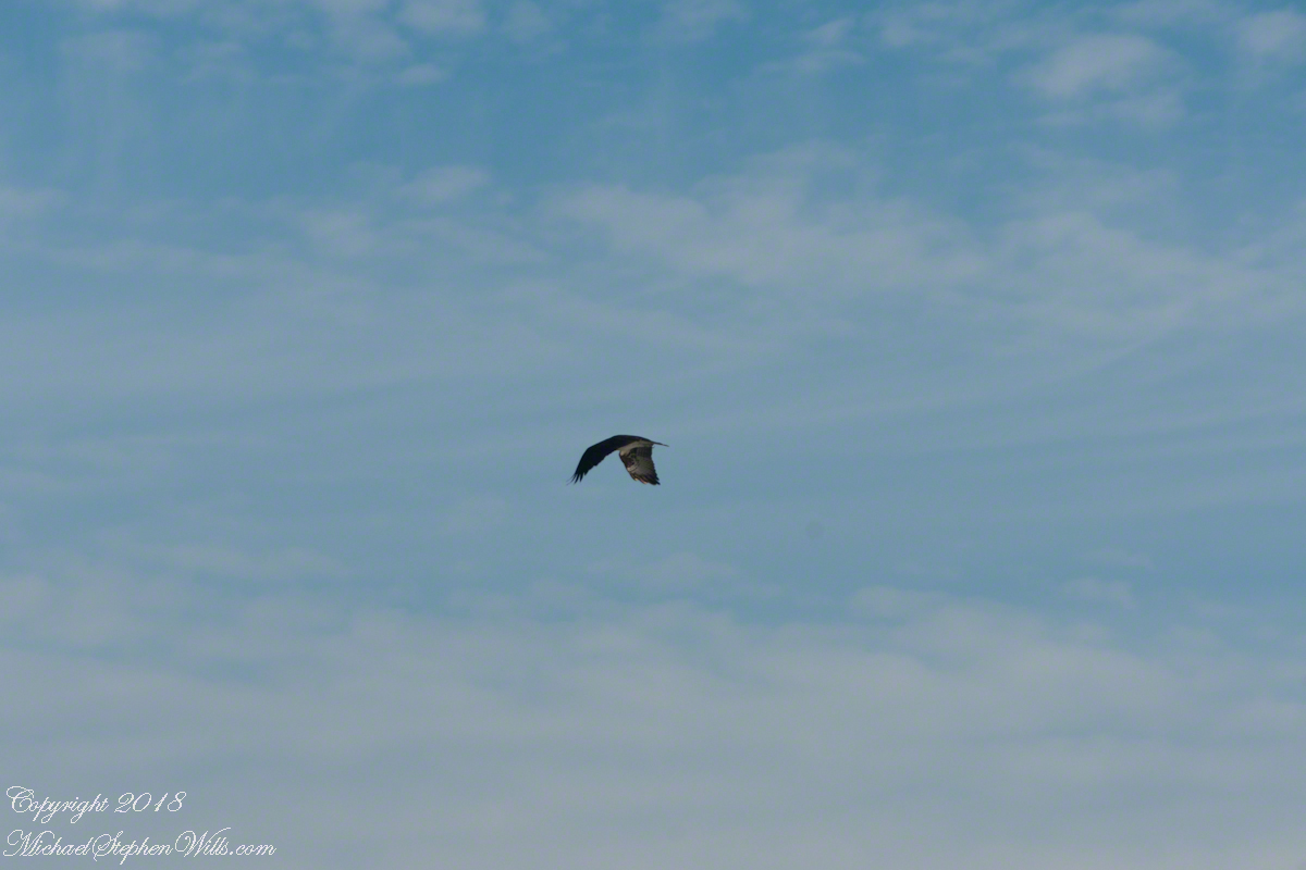
Osprey occupy an environmental niche along 700,000+ shoreline miles worldwide as a single species Pandion haliaetus. A unique bird with its own family, Pandionidae, and genus, Pandion, some experts recognize sub-species in geographic regions. Ours is the Western Osprey.
The following photograph is of a wing shape very different from the gull.
Osprey Stalking Behavior
IPhone 8 always in my pocket, I captured this clip of an Osprey stalking fish in the Atlantic Ocean surf. You will have a better viewing experience by clicking on the title of the embedded YouTube, then click on the Full Screen icon at the lower right.
Enter your email to receive notification of future postings. I will not sell or share your email address.
Copyright 2025 All Rights Reserved Michael Stephen Wills
Hitching the saddled buckskin and lightly packed pinto onto trees on the trail, The Searcher came up to my camp for a visit. I started water for tea and soon we were chatting. Right from the start The Searcher asked for privacy. Devoted to searching the Superstitions for the gold of the “Lost Dutchman Mine”, he assembles his expeditions from a staging point near Phoenix and spends about 60 days a year in the wilderness. Part of his preparation was a desert survival course provided by the Reavis Mountain School, conducted by Peter Bigfoot.
An Invitation from The Searcher
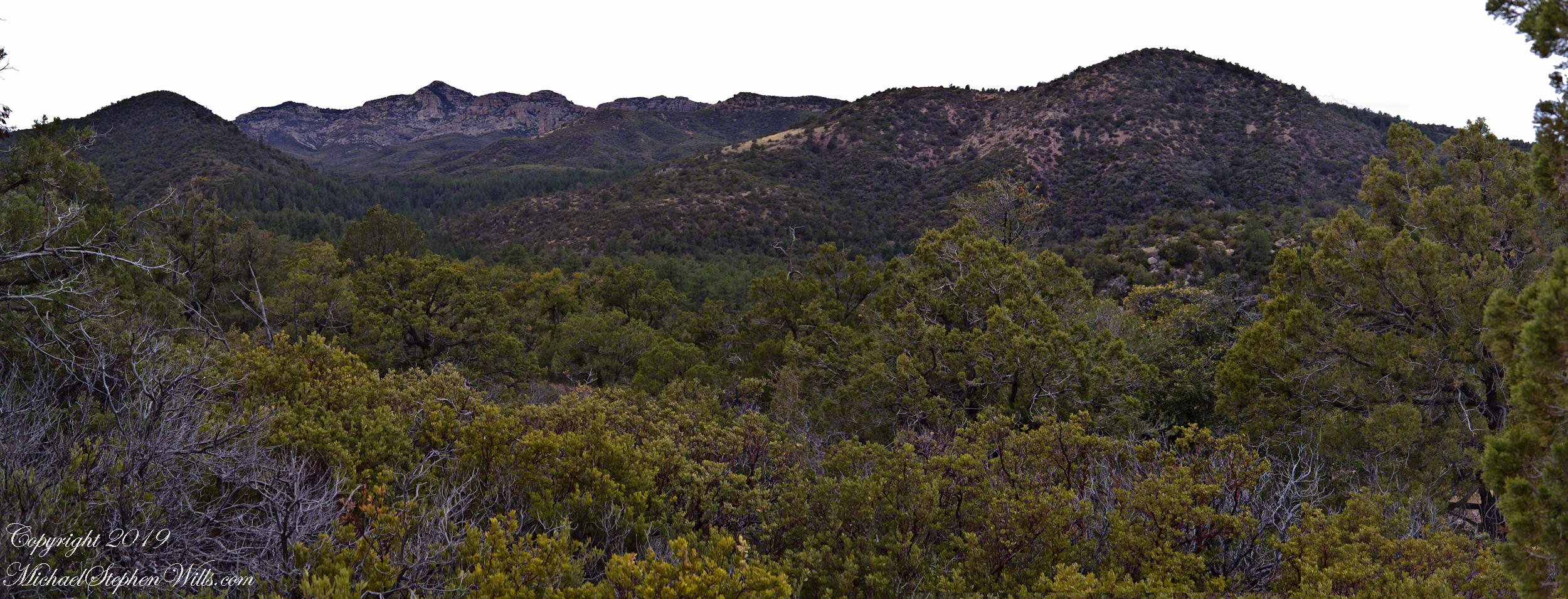
The Search described a place near Pine Creek, he called it “Circlestone,” a large almost perfect circle, of precisely constructed stone wall, on the slopes of Mound Mountain above the headwaters of Pine Creek. My sister, Diane, and I found Circlestone on backpack expeditions March and November 2006.
Here is a panorama from March 2006, southwest from the forests of juniper and pinion on the slopes of Mound Mountain.. The southern tip of Reavis Valley is to the right, from there Arizona Trail lead to White Mountain in the distance. It was taken on a later trip, in November of 2006 when my sister, Diane, and I visited Circlestone.
Click any photograph for a larger image.
The Searcher also told of Elisha Marcus Reavis, who settled the Valley west of Pine Creek in 1874. At one point, a band of Apaches planned to kill Reavis, but were respectful of his reputation as a rifle shot. They were waiting him out across from the his dugout, when Reavis stripped naked and with wild hair and a flaming red beard charge their camp, knives in both hands. The Apaches rode off, wary of his insane behavior, and never bothered him again.
We talked about my prospects and plans when The Searcher offered to take me to the Reavis Valley the next day, on horseback. There is a large apple orchard there and, this being April, we’d be treated to masses of apple blossoms. The day after Reavis Ranch, I could pack out with him down the Arizona Trail, past the Reavis Mountain School, over Campaign Creek and drive back to the Lost Dutchman Park. I readily agreed.
To Reavis Ranch on Horseback
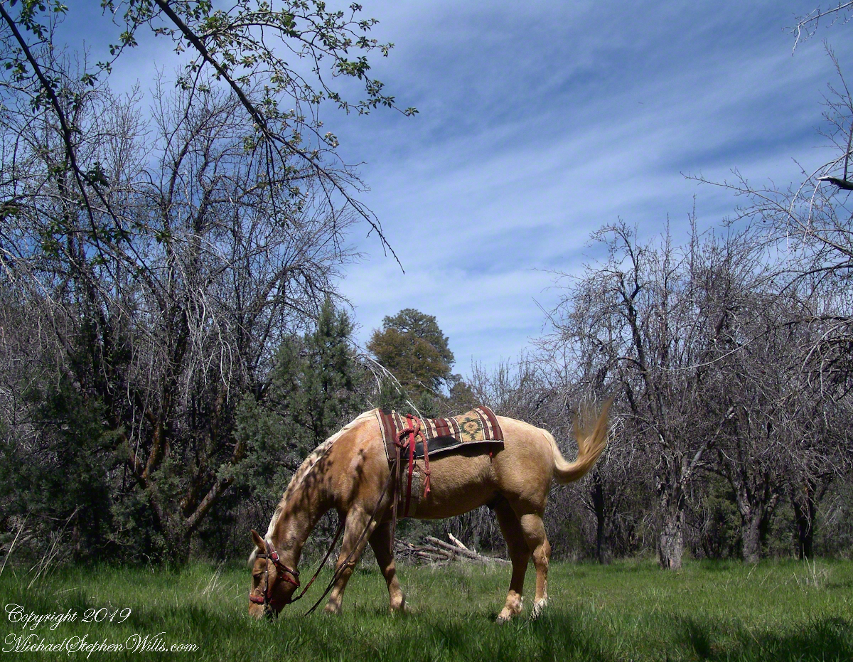
The following morning dawn rose from colorless darkness, thin birdsong and brightening high clouds. When the Searcher arrived around 8 am he was leading the pinto, introduced as Colorado, equipped with a western saddle instead of a pack. As an absolute novice trail rider, the Search would hold Colorado’s lead. The reins were wrapped around the saddle horn, leaving me to hang on and “enjoy the view” and swishing tail of the buckskin, named Nugget.
The 2.5 mile trail to Reavis from Pine Creek is typical of the eastern Superstitions, minimally improved, dramatically uneven with large and small boulders to navigate. From Pine Creek there’s a climb of a 631 feet to 5,278 foot elevation, where it meanders beneath a dramatic red cliff with a view of the pinyon/juniper forests on the slopes of Mound Mountain. As he picked our way, The Searcher pointed out the sights. “Circlestone is somewhere over there, a ring of stones overgrown with Alligator Juniper.” I was able to do little more than observe, photography was out of the question.
A cliff along the trail to Reavis Ranch offered cover and the flat perches preferred by cougars. It was not an issue for us in daytime and attacks against horses are very rare. The most either of us ever saw of the cat in all our time in Arizona was the tip of a tail slipping behind brush. This was a lush April after a “wet” winter, so small game was plentiful. Only a sick cat would be hungry. The worst case scenario is for a cougar to meet and become infected from a rabid animal at a water source and we did not linger on this thought.
Eventually, the cliff descended with the path, steeply, to Reavis Creek, the valley floor and the intersection with the Reavis Ranch trail. Heading south the Reavis Ranch trail passes the site of a long abandoned ranch. What’s left of the adobe and stone ranch house is on a level valley elevation overlooking what used to be the corral and a large open expanse.
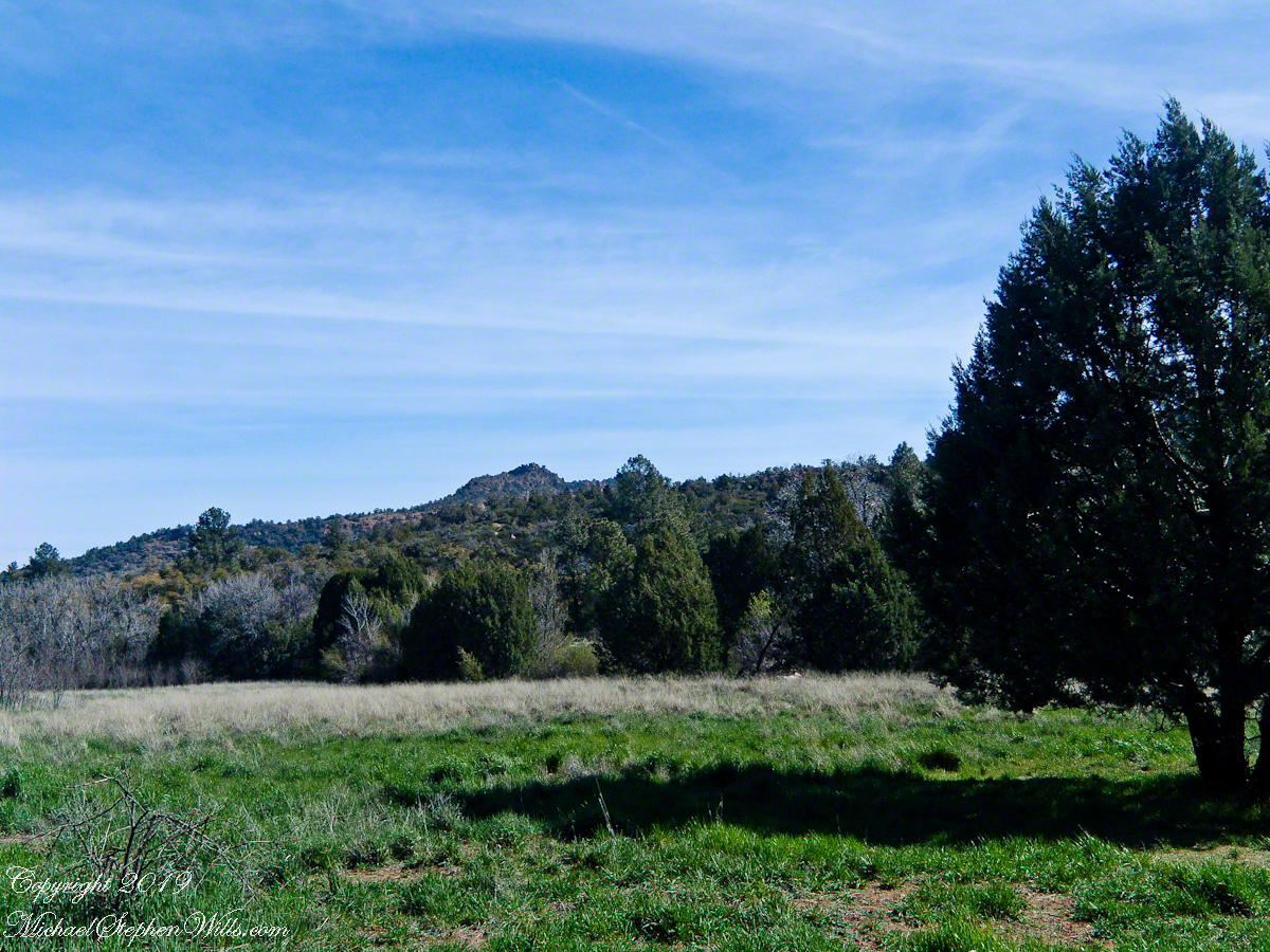
Open field at near the juncture of the trail from Pine Creek with the Reavis Ranch trail.
Apple trees in bloom from the former site of the ranch house. There used to be a pond near this spot. With a little imagination, the trail from Pine Creek can be seen on the far ridge.
Reavis Ranch Trail, foreground, traverses the valley length north to south. The Arizona Trail from Pine Creek following below the red rock cliffs in the distance.
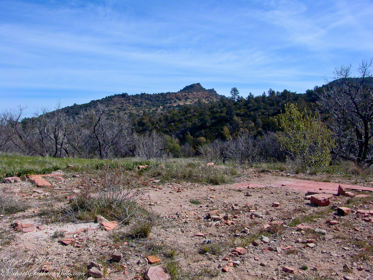
The US Forest Service razed the building after it “burned to the ground” around Thanksgiving 1991. I would not call what is left “a foundation,” it is a platform where the house stood. You can see for yourself in this photograph what was once was a homey tile floor. I’ve seen old photographs of the structure with a large pond to the left of this view, a door and simple porch face east and the pond used to hold irrigation water.
Turn around from this ruin and a platform comes into view. Built on the west valley slope, overlooking the ruined house is a hexagonal foundation of adobe bricks. We are looking here across the Reavis Ranch trail. My opinion about this structure rests on an examination of the land to the south, there is excavation of a shallow canal and this was the way water was captured from the upper Reavis Creek or tributary and directed to this catchment basin where it was then directed for storage or irrigation. The spot enjoys clear views of the central valley, an excellent place to enjoy the fall of evening.
The Searcher led me to a place a few hundred yards south, in a narrowing of the valley, where he let Colorado and Nugget roam free. The horses appreciated the level, open spaces and I enjoyed the Ponderosa pines on the west valley slope. We sat on the smooth trunks of fallen trees, 4 feet in diameter, near Reavis Creek.
Colorado took this opportunity to bolt, headed south. We took off after him into and through a thicket of locust trees where The Searcher cornered Colorado to regain control. “He was abused by his previous owner and is difficult at times,” was how The Searcher put it.
We were close to the end of Reavis Valley where Reavis Creek originates from the drainage of White Mountain, to the west.
We headed north here, back to the ranch house site, to the lush new grass of the apple orchard.
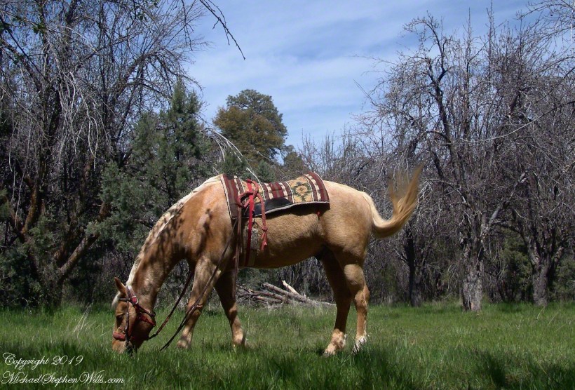
Nugget in Horse Heaven
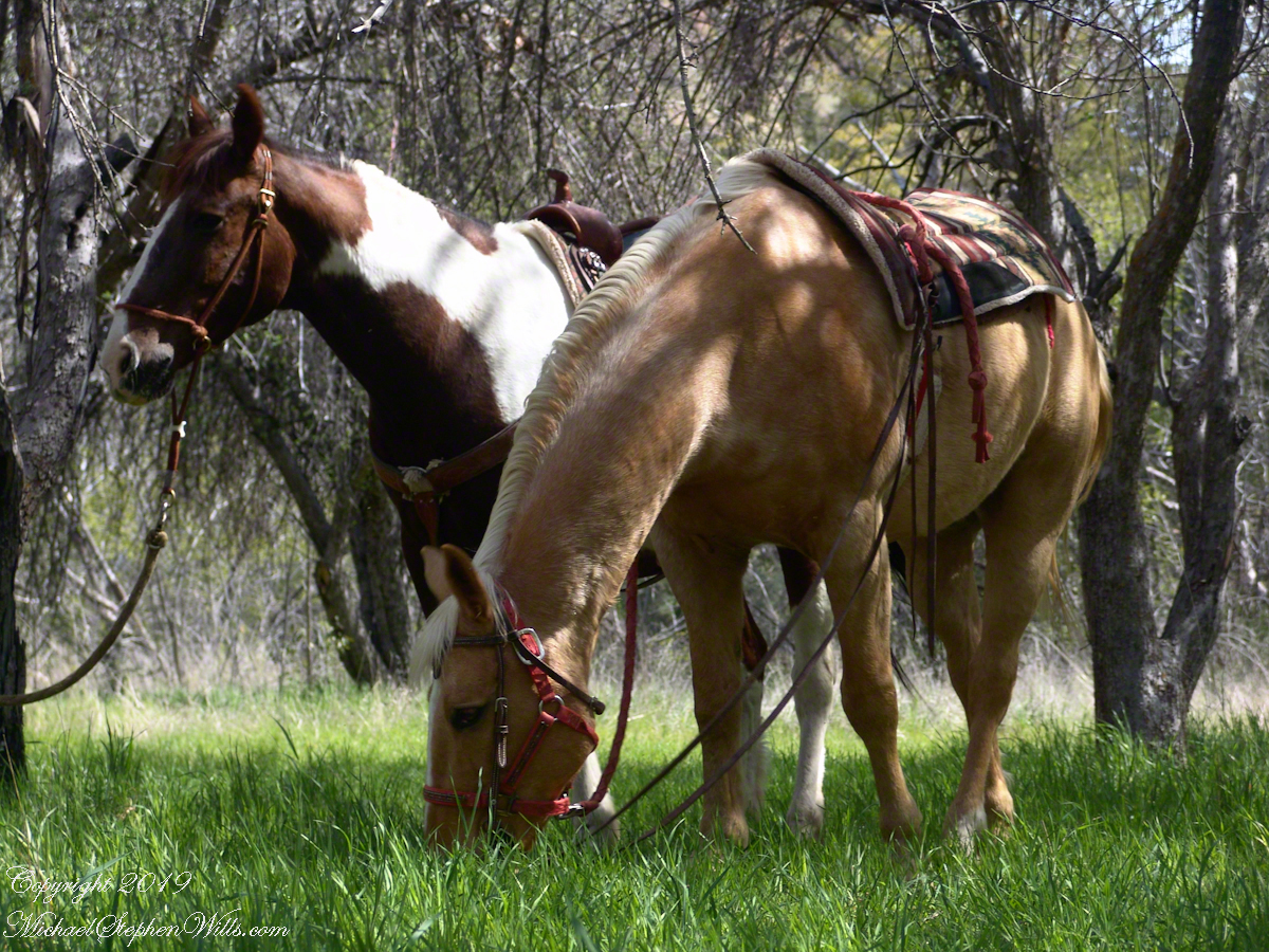
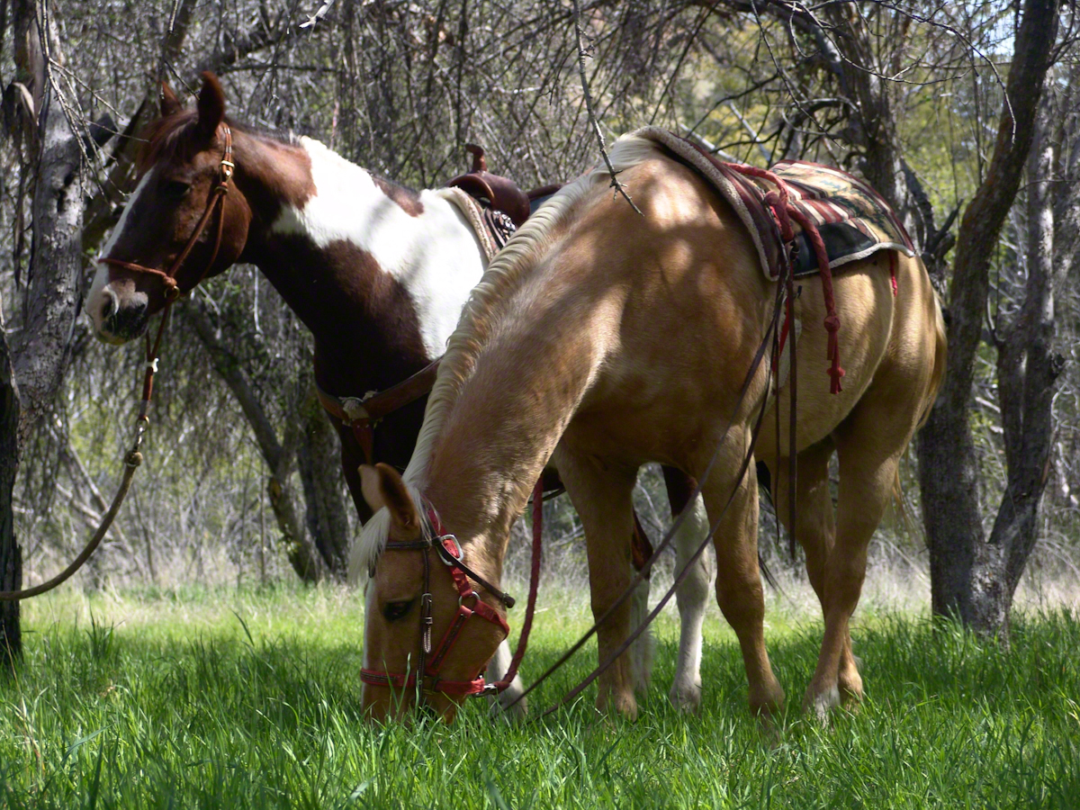
Nugget grazed unfettered. Colorado was tethered with plenty of slack for grazing. This photograph of the pair shows their personalities, Colorado edgy, Nugget content to feast while the grass is available.
Colorado on the alert while Nugget grazes, typical of their personalities.
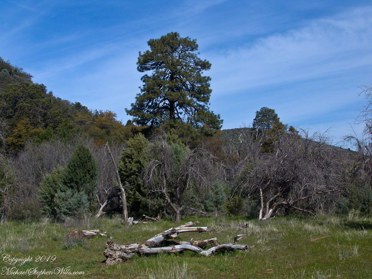
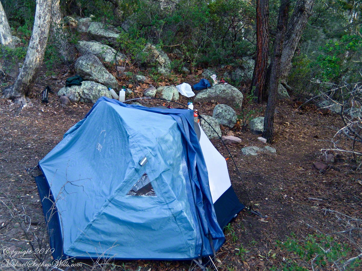
My third wilderness evening was unlike the others. I rested with an unhurried exploration of the camp area. Underfoot was a scatter of dry oak leaves, acorns on hardened desert soil not much softer than the numerous lichen encrusted boulders, all of which formed a bench above Pine Creek.
Pine Creek Camp Overview from a large lichen encrusted boulder
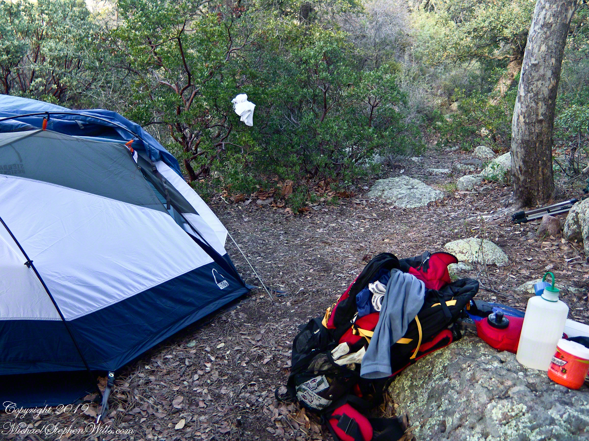
Pumping a gallon of drinking water though the ceramic filter takes more time than meal preparation. The four gallons I packed up were almost used and I enjoyed the luxury of pumping two days supply, 3 gallons in all and planned to down a quart or two of “gator aid” before dinner with the luxurious enjoyment of a flowing Pine Creek for company.
Pine Creek is the most common type for Arizona, recurring. To recur means to happen periodically or repeatedly and, for streams, this means for part of the year no water flows. For these days the flow was low, the water clear, what was left from the plentiful winter rains of 2004/2005.
Looking east toward Manzanita thickets with the unpacked backpack foreground
The wind gently rustled the manzanita and the sun just above the western cliffs as I settled on a boulder to enjoy a quart of fluid. I mulled over my next steps.
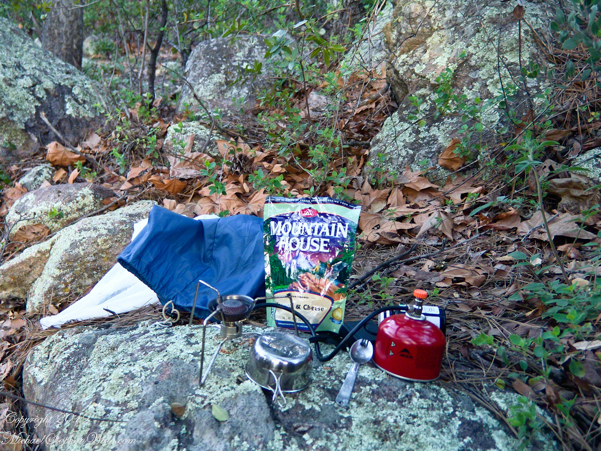
The kitchen: a very light gas burner, spork, dehydrated food with cup for beverages
Initially, the plan was to walk across the Superstition Wilderness, starting on the remote eastern end and emerging on the populated west side, in the Lost Dutchman State Park. My sister expected me there on day 10, but today was the end of day three. I didn’t know at that time the climb on my second day was the steepest of the wilderness and the way forward was much, much easier.
Looking west toward pine creek, manzanita branch foreground and thickets all round, young Ponderosa Pine, Arizona Oak behind tent.
Before a decision could be reach, my thoughts were broken by a different sound from the manzanita: several horses approaching on the trail.
Here is a photographic recap of the previous Superstition Wilderness postings as a gallery. You can page through the photographs.
View to the southwest on the Arizona Trail above Pine Creek.
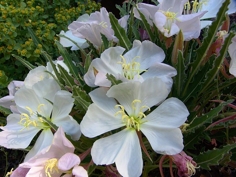
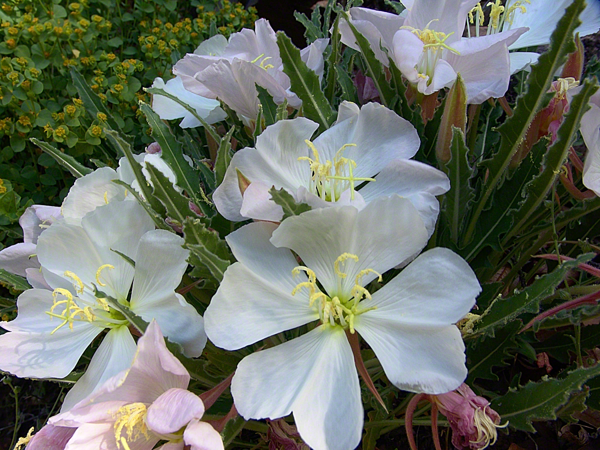
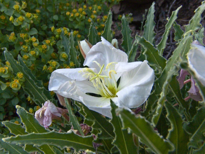
Pine Creek of the remote eastern Superstition Wilderness hosts this wild Tufted Evening Primrose.
The Arizona Trail passes this spot in the remote eastern Superstition Wilderness. This is the view of my path up from Nameless Canyon. In the distance is the Four Peaks Wilderness Area.
Yesterday, I simultaneously published nine photographs on my ImageKind Ireland Gallery and Getty IStock (click the links to visit): nine views taken from the slopes of Slieve Gullion.
Sunday, May 25, 2014 was a happy day for Pam and I. It was the first full day of an eighteen (18) we filled with Ireland, travelling in a loop of the island following the coast from, naming the counties where we spent time on the ground, Louth, Armagh, Dublin, Meath, Wicklow, Cork, Kerry, Claire, Mayo, Antrim, Down and back to Louth. The counties of Northern Ireland are in italics. Indeed, at this time the politics allowed us to travel freely between the Republic and the North. That day, our morning was spent in Louth attending mass, enjoying our first meeting with the family over a substantial mid-day meal (click the link for my Facebook album of the meeting). We split off that afternoon to visit the home of my cousin, Mary and her husband Joseph in County Armagh, just over the border. When Joseph offered to drive us over to Slieve Gullion it was totally new to us, we had no conception of the place or what to expect.
It was such a gift, we are grateful to Joseph for this experience. Only in 2018 when, at 64 years of age and retired”, was I able to research the place and spend time developing the photographs for publication. Two of the photographs illustrate this posting, to view the others in my online gallery, click either photograph.
Slieve is the Irish language word for “mountain.” Slieve Gullion is a lone eminence, one remnant of volcanic eruptions about 60 million years ago during the rifting of continents that produced the Atlantic Ocean. Around the mountain is the Ring of Gullion, a string of hills, 26 miles by 11 miles, surrounding the mountain and formed from the ancient collapse of a volcanic caldera. The technical name for it is a Ring Dyke and it was the first of its kind to be recognized and mapped, well before the nature of the formation was understood of be volcanic. The name Gullion is derived, in one formulation, from the name of the metalsmith, Culann. In Irish Myth, Culann’s home and workshop was on the slope of Slieve Gullion. A wealthy and respected personage, Culann invited Conchobhar mac_Neasa, king of Ulster to feast. During his approach to the mountain, passing through the surrounding plain, the king stopped to watch boys play hurling. Among them was the future hero of Ulster, the young Sétanta. Impressed with Sétanta athletic abilities, the king invited him to join in the feasting at Culann and the boy promised to follow after the game. Later, while climbing the mountain to fulfill his promise Sétanta was attacked by the guard dog of Culann. The myth says the dog was killed by Sétanta in self-defense. Never the less, in compensation to Culann, Sétanta committed to rearing a replacement and to act as guard dog in the meantime. In this way he became known as Cu Culann, “the dog of Culann.” Click for more about Cu Culann.
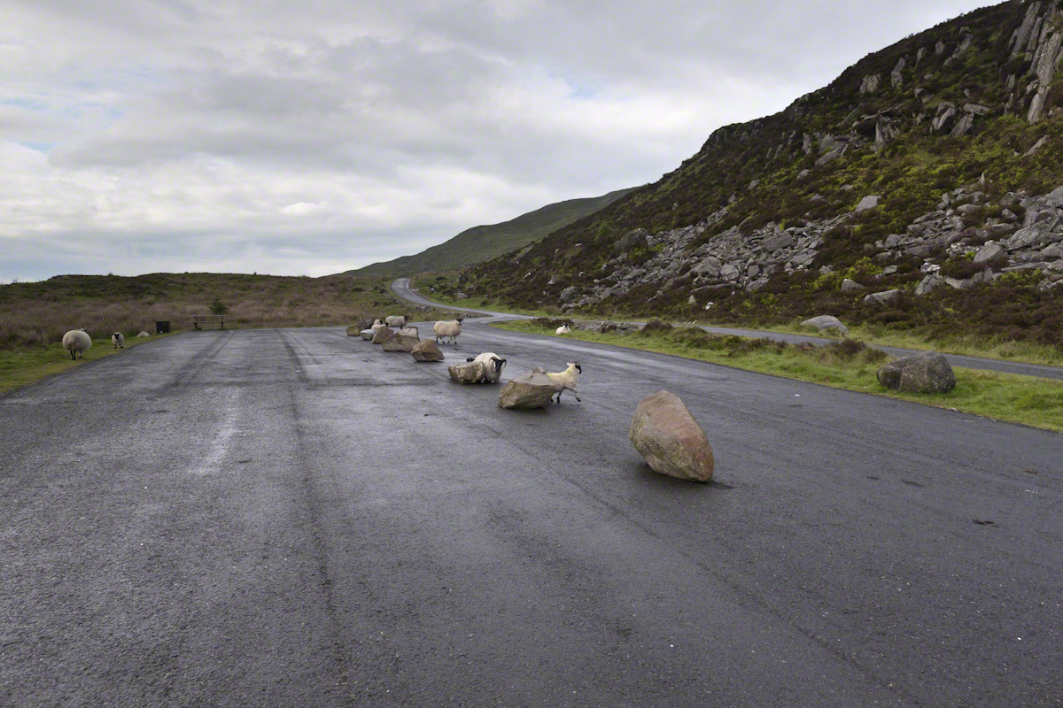
On the summit two cairns north and south of a small lake, tangible proofs of ancient peoples and beliefs. The north cairn is a more ancient passage grave, 90 feet wide, 16 feet high, the opening aligned with the setting sun on the winter solstice. The cairn north of the lake is less ancient containing two cist burials. For our visit Joseph drove us along the 8 mile drive. The following is an image of a viewing platform and the road. Just beyond, on the right, where the ridge meets the road, is the trail to the 1,880 foot summit of Slieve Gullion. Our arrival disturbed sheep resting on the asphalt. I’d have loved to spent a day climbing the summit, but it was not to be this trip.
The way is part of the Slieve Gullion Forest Park. Throughout are turnoffs to admire the view. It was during our frequent stops I pulled out the photography gear to grab the views. Here is one, looking southwest. For the other views, click either photograph to visit my Online Gallery of Ireland.
Copyright 2021 Michael Stephen Wills All Rights Reserved
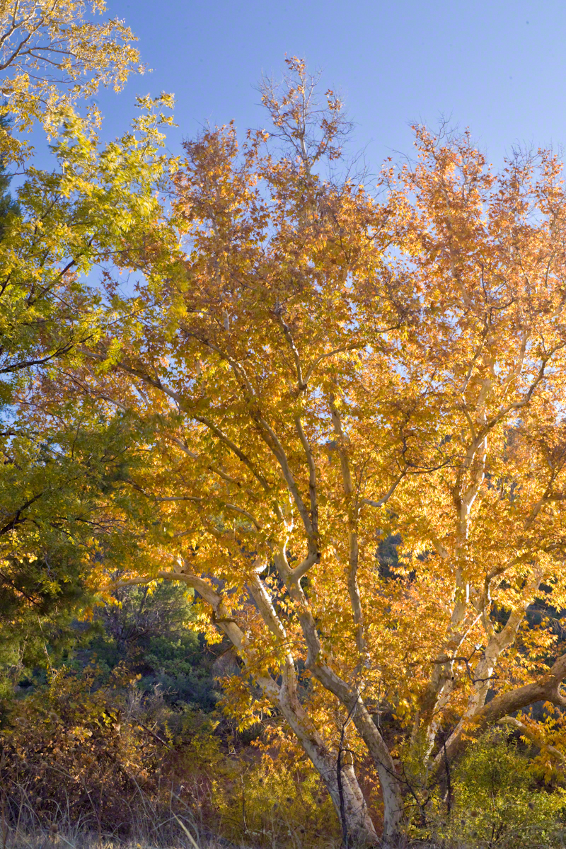
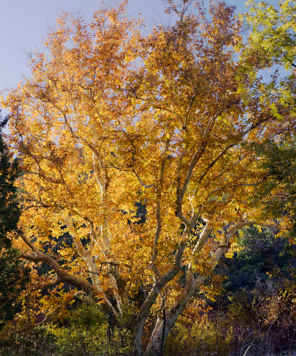
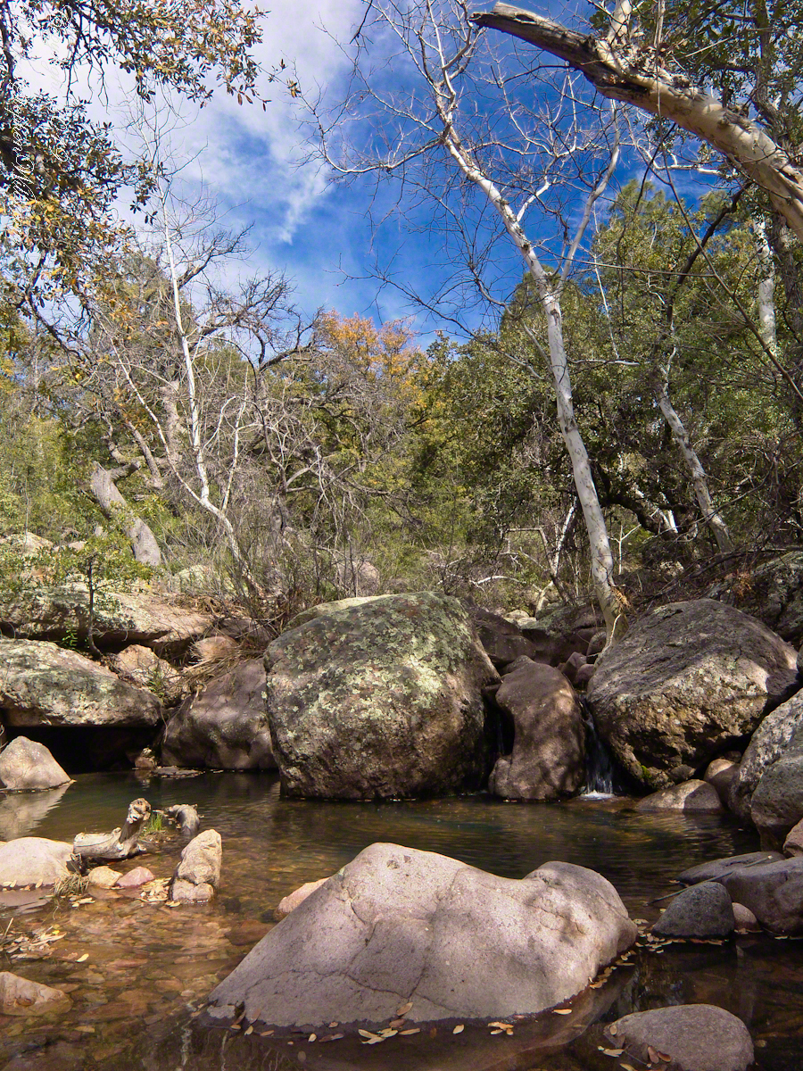
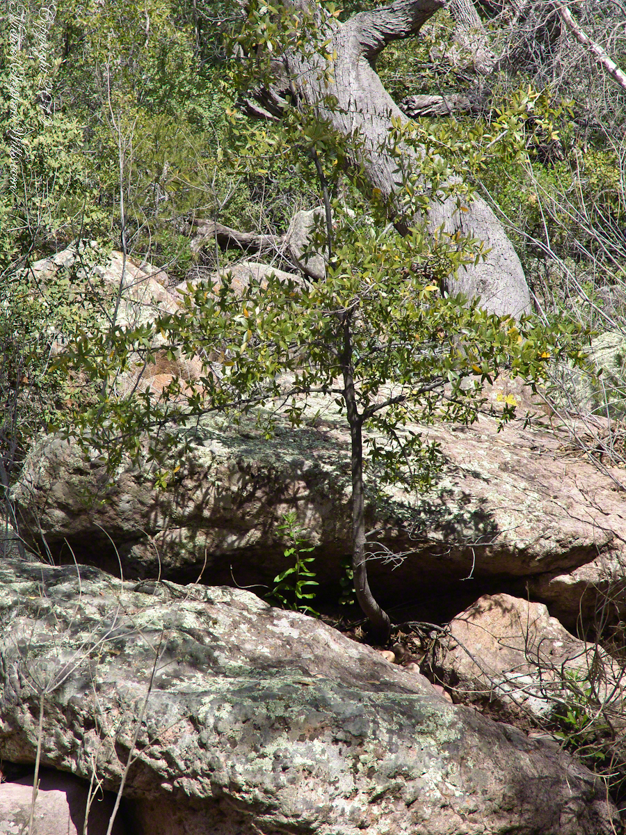
Compare these Arizona Sycamores with the struggling specimen from the last chapter, “A Peaceful Day at Pine Creek.” Many Sycamores such as this one flourish along Reavis Creek, a perennial stream of the eastern Superstition Wilderness. The drainage that feeds Pine Creek is far less acreage than that of Reavis Creek and, when the Pine Creek flow fades in the driest seasons, plants go into survival mode and halt growth and may even slough off limbs to conserve water.
These Sycamores grace a stream that seldom stops flowing, even in the driest of seasons. I had the good fortune to visit the Reavis valley of the Superstition Wilderness in November 2007, when these trees were at peak autumn foliage.
The tree requires a supply of water to thrive. This specimen demonstrates the species growth habit growing multiple trunks with a shape driven by water availability and the environmental context. The multiple trunks may be a desert survival mechanism. In dry periods a trunk or trunks are sloughed off to reduce moisture loss. This is why the Sycamore of “A Peaceful Day at Pine Creek” has a single trunk.”
To encounter a riparian space of the Arizona desert is a revelation, to progress from Sonoran desert spaces assailed by the breath of dry wind, to see the first signs of water in the distance as a welcome fluttering of leaves, to feel a welcome odor of water.
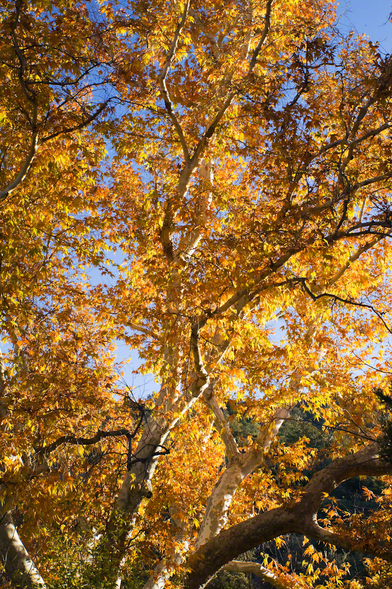
Yes, the first effect of a riparian space on the senses is the smell of water. Let’s finish this post with limbs of the Reavis Creek Arizona Sycamore reaching for the sky.
The spring gales persisted through my late afternoon arrival in Pine Creek, into the night and next morning. Protected from the west wind by the rising land, the tent was not buffeted like I described in the chapter “A Dry Piece of Paradise.” The song of soughing pines was my last impression of the evening and the first of the next morning.
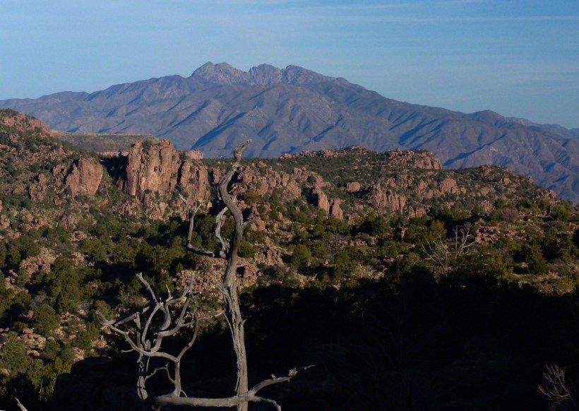
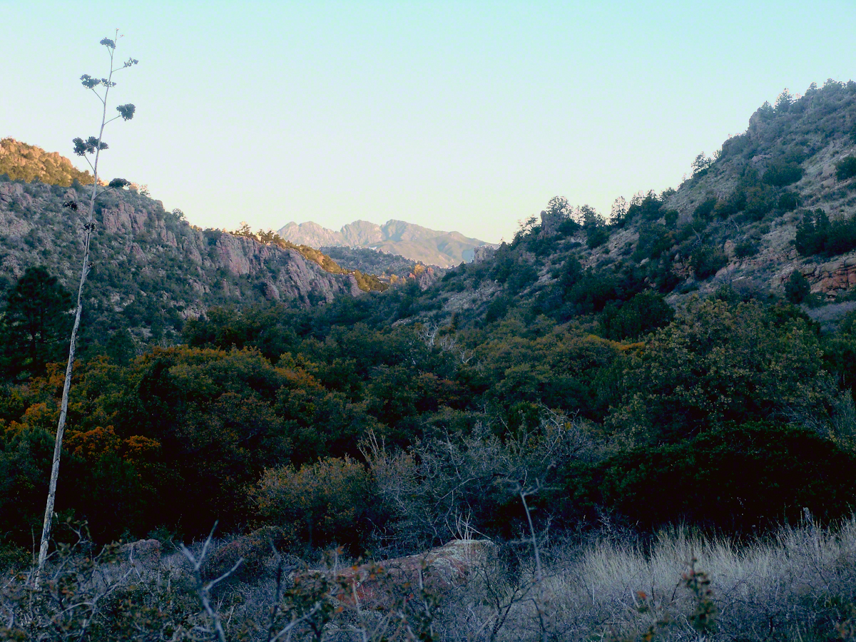
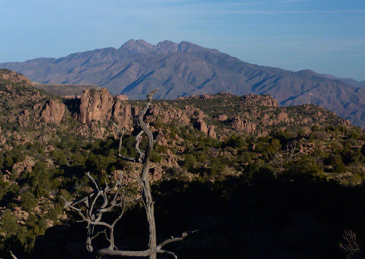
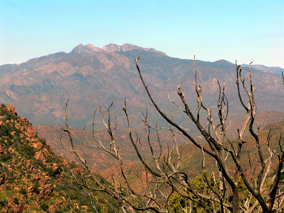
Where the Arizona trail crosses, Pine Creek flows at 4,600 foot elevation through a canyon of broadly sloping sides. The flow originates at the foot of Mound Mountain to the southwest, at 6,253 feet the highest elevation in the Superstitions. There are 5,500 foot peaks to the east and west. The land falls away to the north giving great views of the Four Peaks Wilderness.
I chose a flat site to camp above the creek among Arizona White Oak, Arizona Sycamore, Ponderosa Pine and Manzanita. Of these, it’s Manzanita fruit for which the bears come in the summer. Manzanita thickets made approach to the camp site difficult from all directions but the path. Bear sign was thick among this growth. Go to my chapter, “Racing the Sun,” to see the red barked Manzanita and pink blossoms from which grow tiny green fruits that ripen summertime into a bright red, like tiny apples. Indians used this bland tasting fruit containing five hard seeds for food and a cider beverage.
Well before dawn I grabbed warm clothes, hat, camera to head out for a full day of leisure.
On a shallow rise above Pine Creek I took the two shots of agave (Century Plant) stalks in dawn light. These start the chapter, “A Dry Piece of Paradise.” One dry agave flower is to the left in this North view, looking down the creek not far from the creek crossing.
Click any photograph for a larger view
North View from Pine Creek, early morning
In the photograph notice how the canyon narrows as the creek flows north, the walls rising above it for hundreds of feet.
When I climbed about 200 feet above the creek to a ledge that provided great views, the protective canyon walls fell away and wind gusts threatened to up end the light tripod. It was necessary to anchor it with the daypack and I tied down my hat as well.
Shadows of night lie below, dominated by Four Peaks Wilderness. A unique long flat ridge is behind the near dramatic ridge above Pine Creek. This view leads me to daydreams. The long ridge is clearly visible in two photographs titled “Nameless Canyon in the Dawn” and “Nameless Canyon Morning” of my post “A Dry Piece of Paradise.” A view from the west is available in my post “Racing the Sun.” Look at the photograph captioned, “Overview of my path to the Nameless Canyon behind Two Bar Mountain,” the flat ridge is just above the shadow of Castle Dome. The view from that spot must be incredible across the lower Reavis Creek valley. From here it is a day trip 4+ mile roundtrip bushwhack over the cliffs above Pine Creek.
North View from Pine Creek
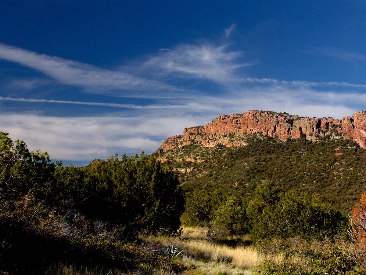
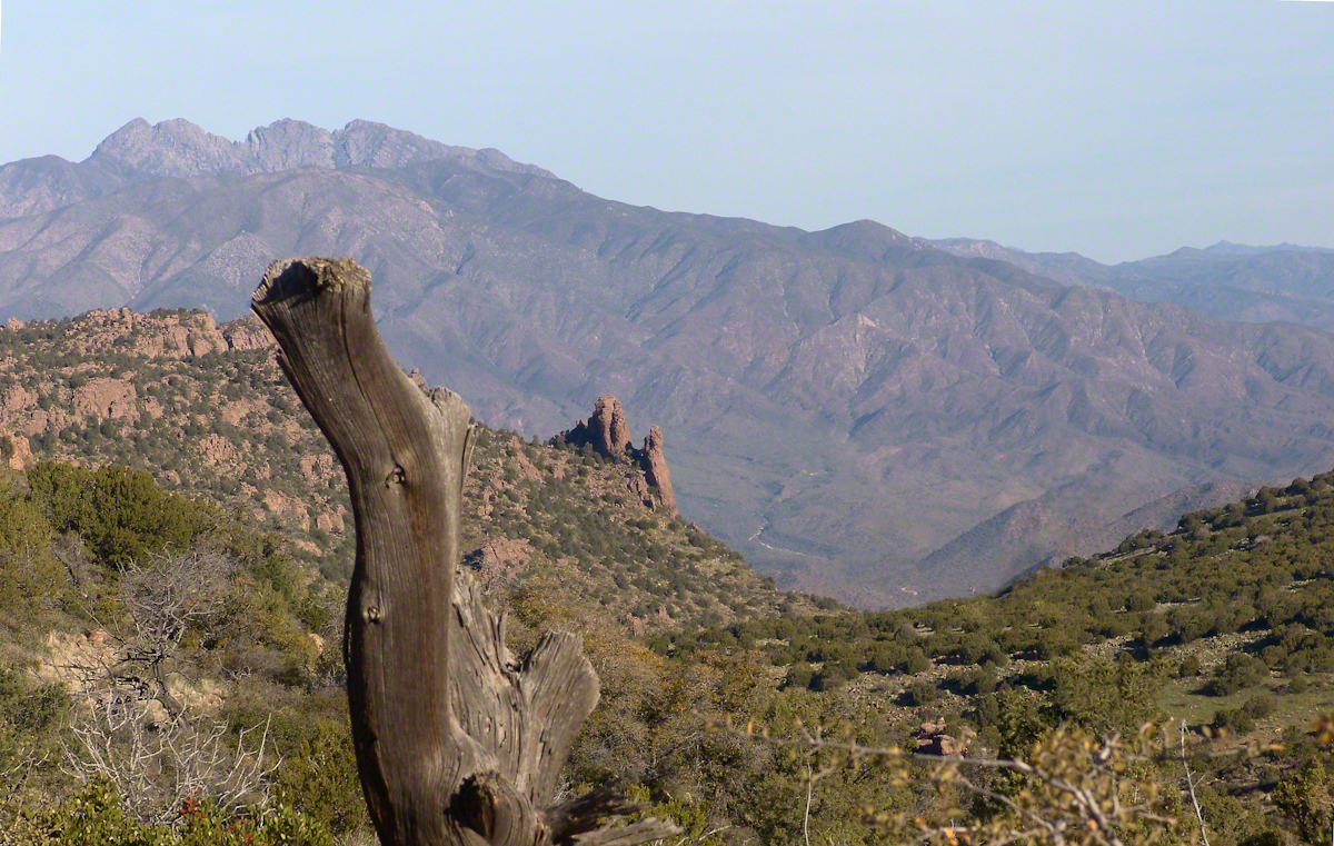
Those evergreens in the following photograph are Oneseed Juniper (“Shagbark Juniper”) of the three species common to the Superstitions, this has this spherical, bushy appearance. Here the elevation is just high enough for junipers because there are none down below. The trail crosses Pine Creek to ascend the lower slopes of these red cliffs, following it around to the west and over to the next valley, Reavis Ranch, a distance of 3.5 miles. In my “Two Meetings” blog is a sweeping view of Pine Creek Canyon, from the southern approach.
For most people a 400+ foot climb over these steep cliffs is impossible. Fortunately, a saddle to the right of this photograph is a possible route.
Southwest View from the Arizona Trail above Pine Creek
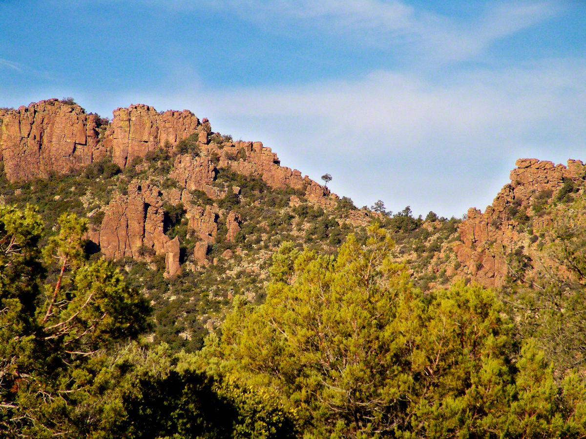
The saddle is 100 feet lower without cliffs. Still, this entrance to remote, fascinating locations is a steep 300+ climb.
A Saddle breaks a line of cliffs
“The Searcher” arrived around this time riding the buckskin gelding and leading a pinto. He saw me and my camera equipment and stopped for a chat. His plan was to follow the trail I came up yesterday to find a rumored camp with good water. The howling wind made conversation difficult. I wondered where his camp of last night was located, since there was no sign of him. Before I could ask, his cowboy hat flew away with a wind gust. He hopped off the gelding, “That’s my best beaver hat.” After a quick brush and tie-down they were off.
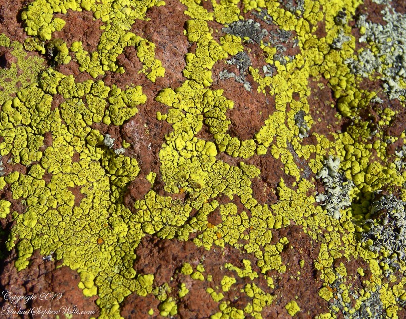
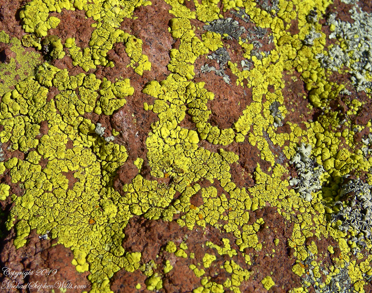
Heading back down to the creek, here is a macro of lichen that covered the crumbling surfaces of boulders that littered the slope.
Nature’s Abstract
During the previous night fresh primrose blossoms opened, this one flourishing in the earth of a south facing slope. There is a reddish spent blossom at lower left. The soil here formed over eons by the action of the creek water, atmosphere and plant life. I have more about the Primrose and these yellow flowers in the background in my “Two Meetings” blog.
Pine Creek of the remote eastern Superstition Wilderness hosts this wild Tufted Evening Primrose.
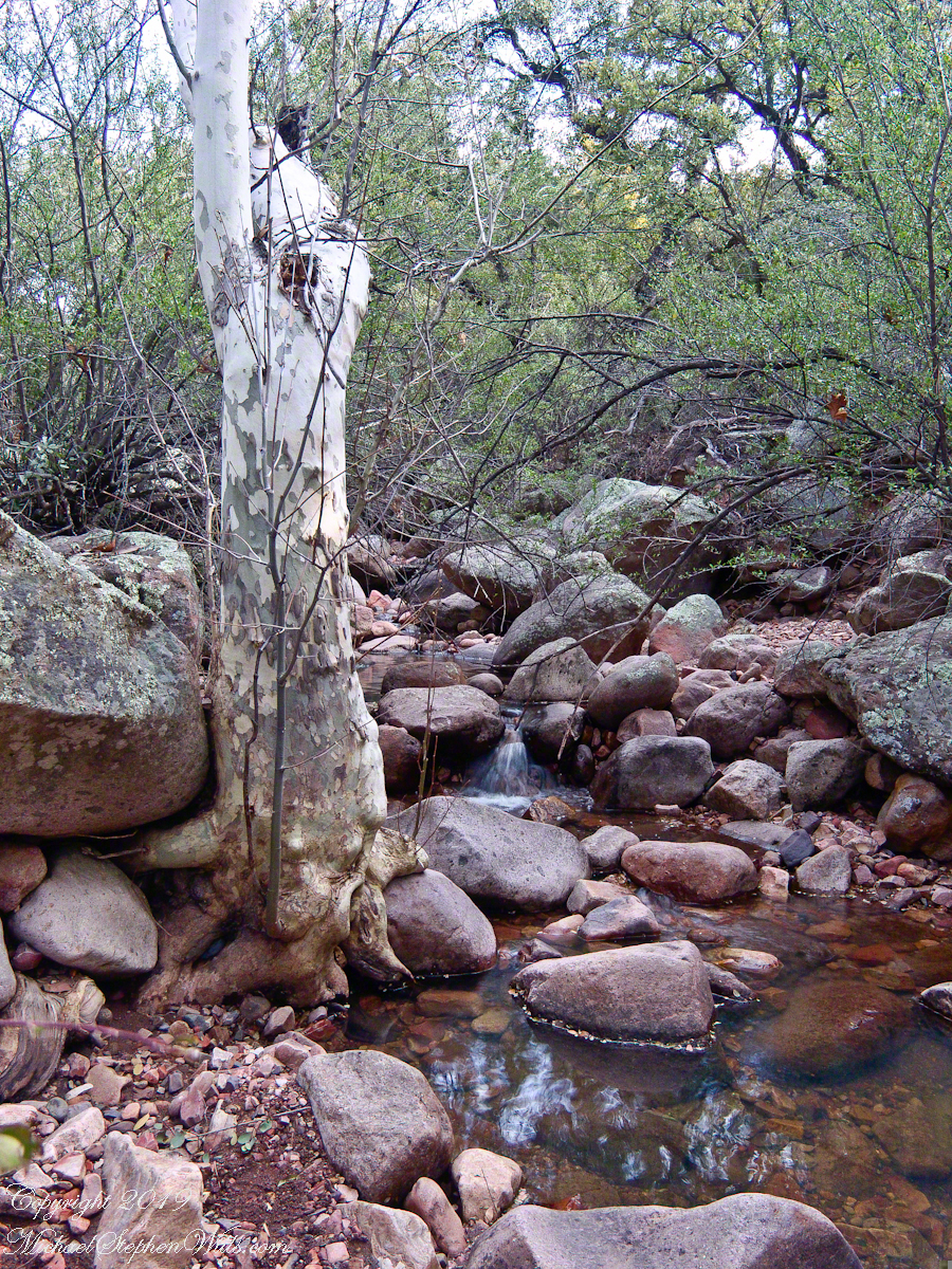
Turn left (up stream) where the Arizona Trail crosses Pine Creek and jump boulder to boulder for a hundred feet or so and you come to this view. The creek bank, covered by vegetation, rises on both sides and makes it difficult to leave the creek. Those are Arizona White Oak leaves floating along the large foreground boulder.
Pine Creek Pool with Young Arizona Sycamores
This is a very young Arizona White Oak, common species growing along the creek. The leaves are not what you’d expect from an oak, being 2 – 3 inches long in the shape of a lance blade and without obvious lobes Mature Arizona White Oak has a rough bark and, at most, 24 inch trunks.
Arizona White Oak
There are better examples of grand Arizona Sycamores along the perennial Reavis Creek. Pine Creek does not flow in the driest seasons, this tree sloughed its branches in order to survive. You can see from the many young Sycamores in the Pine Creek Pool photograph the previous photo the sycamores are successful in this environment.
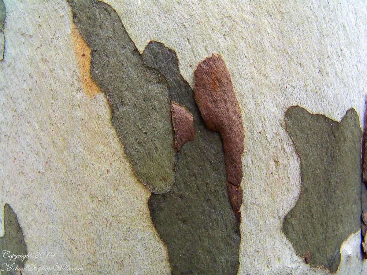
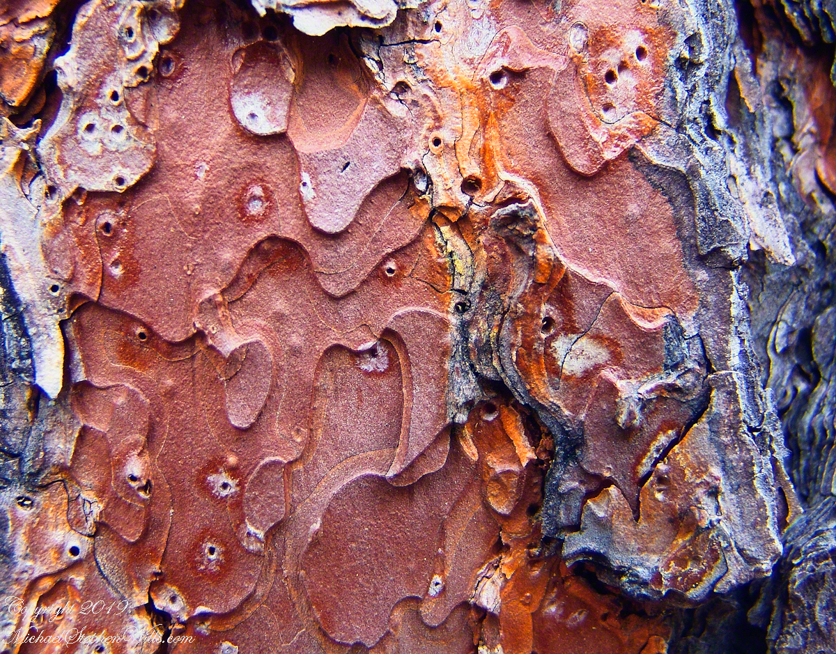
I spent some time with this Sycamore, capturing abstract patters of the bark.
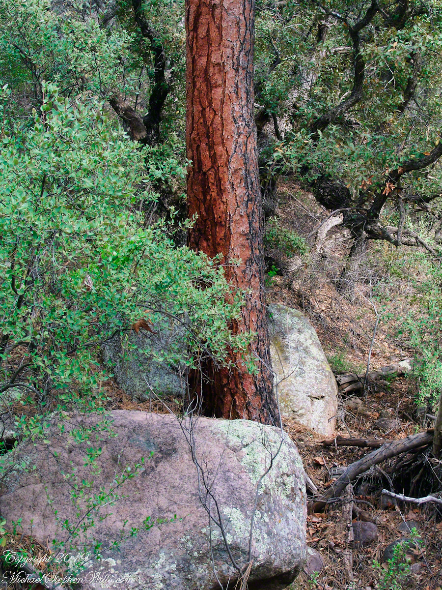
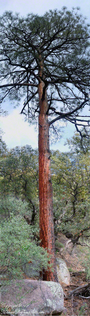
The abundance of Ponderosa Pines here demonstrate the species thrives at this altitude and dry environment. This specimen grows on the creek bank. Those are shrubby Arizona Oaks around the trunk.
Abstract patterns in the bark of this Ponderosa. The popular and scientific name (Pinus ponderosa) for this species is from the dense weight of the wood.
The tree is over 100 feet tall. I patched together four shots for this view.
In the afternoon I explored the Arizona Trail to Reavis Ranch. It crosses the creek to ascend the cliff in broad switchbacks. Eventually it follows a contour below a cliff with fine views of Pine Creek Canyon. I turned back to leave the hike to Reavis Ranch for another day.
Imagine a bowl with steep sides, rough and sharp in places.
Look along the bottom and see a silver stream, sparkling and singing through rocks.
A figure is clinging to the upper side, almost to the rim.
The figure is me in the setting of my blog, “A Dry Piece of Paradise”. Here is my view from that spot.
View from the rim of Nameless Canyon
Hiking along this bowl rim I came to a clearing in the juniper and Manzanita bushes, with a fire ring and pile of roughly broken wood with outstanding views on all sides. This tradition of leaving wood is a welcome intrusion of human kindness and sympathy in this wilderness. We gather wood for total strangers, people we will never meet, to potentially save them in a rainy, cold darkness.
At noon Pine Creek was two miles ahead as I looked into a steep descent, a wide canyon and open range of low oaks, almost shrubs, and small juniper trees. Later, well along the trail, I stepped over Walnut Spring, a silent thread of water through a thin blaze of trees, yellow flowers and continued toward Reavis Gap and Pine Creek on Oregon Ed’s recommendation.
“Even a blind man could find water there this year,” Ed claimed.
Ed’s van was parked at the Superstition Wilderness Tule trailhead when my sister dropped me off the morning before. She noted the van thickly coated with dust over grey primer with an Oregon license plate and changed her plan to accompany me the first mile or so for fear the van’s owner was lurking inside.
It was just as well Diane stayed behind because I met Ed two miles up the trail that first day. From the start, Ed was too outgoing and his pack more empty than light. He chatted me up on how “blue my shirt was”, seen from above, about his trips from Oregon to Arizona a few times a year, about his claim to be returning from a five day round trip to Tortilla Flats.
Ed’s good news about how the usual springs were flowing was welcome. Then, Ed expected me to give him some water for this information. This expectation of his was irrational, given his reports of good water sources. Plus, Ed was only a few miles from his van showed no physical signs of needing water.
I was to discover, a few hours in the direction he claimed to have walked, a flowing stream.
Ed’s attitude changed upon his spotting my .45 in a tactical holster strapped to my leg. Thirty seconds later he was heading down the trail. I had no water to spare and was relieved I didn’t need to escort Diane back to her car. Maybe Ed was an anti-gun advocate, but my conclusion was he had some lurking to do, back at the van.
While planning this trip I imagined “Reavis Gap” to be a narrow trail between towering peaks. While walking under the water heavy pack I elaborated on this expectation, but coming on the gap I walked through and into the reality of this photograph, taken from a point looking over the gap and down into Two Bar trail. This was the site of my first meeting with “The Searcher.”
North from Reavis Gap
“The Gap” itself is a high, narrow ridge over a 7,000 foot high valley with peaks, ridges and the occasional hoodoo. That rock formation in the mid-distance includes a hoodoo. It was this hoodoo that introduced me to the gap, being what I saw first high above in the distance from Walnut Spring, a silent thread of water through a thin blaze of cottonwood trees and yellow flowers.
Here’s a link to a video I did of a vast field of Wild Oats which covered Reavis Gap that season.
I first saw the “The Searcher” on that high, narrow ridge above Two Bar trail. I guessed he was a mounted park ranger; from the wide brimmed hat he was holding and the loose fitting shirt. From a half mile away his golden brown mount was standing steady, apparently at rest. Walking up that long, moderate grade my feet hurt and the 70+ pound pack, heavy with water, was chafing. Eager to climb the steep ridge ahead, between me and Pine Creek, I passed the signpost marking the juncture of Two Bar and Reavis Ranch trails and headed up that rocky ridge.
The clatter of horse hooves came up behind much sooner than expected. Turning, I came upon the unexpected site of two horses. The mounted stranger was not a park ranger, but a well dressed cowboy on a western saddle, riding a buckskin gelding.
Behind them, on a lead, was a brown and white pinto loaded with panniers.
I was polite and climbed up on the rocks, off the path, to let them by.
Here’s a photograph of these horses, taken a few days later.
“Colorado and Nugget, grazing at Reavis Ranch”
Enjoying the lush grass of the Reavis Ranch apple orchard, Colorado and Nugget graze.
Our chat was brief, but practical and meaningful: where we came from and conditions along the way. The stranger, who I came to call “The Searcher”, inquired about conditions in the very steep bowl behind Two Bar Mountain. He planned to camp overnight and do a Two Bar Mountain daytrip the next day, but would not if the trail was washed out by that spring’s heavy rains.
I replied the trail was obliterated in spots and even though I could pass his horses might not get by. His reply, “If you got up, so can they.” And with that he gave the buckskin a nudge and they were soon out of sight, over the ridge.
Fifteen minutes later this was my view of Pine Creek, a valley of steep sides sloping to a stream of cool water with mountains and sheer cliffs on all sides. Part of The Arizona Trail.
From a vantage point overlooking Reavis Gap tot he north. This is the view of Pine Creek, to the south.
Just before reaching Pine Creek I passed a southeast facing bank sheltering a garden of tufted evening primrose and a member of the crassulaceae family both in flower. The white flower is the primrose and the yellow the crassulaceae. I was so moved by the beauty of this patch, after trekking for seven hours through endless rocks, cactus, juniper and oak, I unloaded my pack and captured this shot. As the name suggests, the flower is an evening bloom that wilts in the day’s heat. That’s why the flower is a bit floppy in this late afternoon photograph.
Note flower b
The crassulaceae is a succulent, similar to a kalanchoe, with tiny flowers composed of tiny yellow balls.
In future chapters you’ll see more of Pine Creek, visit the wilderness apple orchard at Reavis Ranch, learn more about The Searcher and an ancient, circular, rock wall on a peak overlooking Reavis Gap.
Here is a gallery of photographs from this post for you to flip through. Enjoy!!
Superstition Wilderness, Arizona
The Arizona Trail passes this spot in the remote eastern Superstition Wilderness. This is the view of my path up from Nameless Canyon. In the distance is the Four Peaks Wilderness Area.
Enjoying the lush grass of the Reavis Ranch apple orchard, Colorado and Nugget graze.
From a vantage point overlooking Reavis Gap tot he north. This is the view of Pine Creek, to the south.
Pine Creek of the remote eastern Superstition Wilderness hosts this wild Tufted Evening Primrose.
This primrose growing in the remote eastern Superstition Wildreness is drooping at day’s end. These flowers rely on the hawk moth for pollination.
Rocks such as this are a favorite perch for leprechauns to rest and contemplate the works of man who have invaded their world. Inhabitants of Carlingford who wander Slieve Foye have come upon them often enough, their stories and certitude in the existence of the Little People are resistant to manifold doubters with their reasons and arguments.
Kevin Woods, aka McCoillte, was a doubter until worked on a stone wall on property he owned on Ghan Road, Carlingford. His belief did not arise on the discovery of the leather purse, covered with ages of dust and lime, nor with the gold coins inside. McCoillte pocketed the coins for luck. As luck would have it, McCoillte loved to walk on Slieve Foye. It was on one such walk he and his dog encountered Little People who paralyzed them to escape. His unexplained absence led to troubles with the wife.
This experience brought McCoillte around to enough of a belief that he, with lots of help, succeeded in petitioning the E.U. European Habitats directive to recognize leprechauns a protected species. According to a page on the Celtic Times web site, “The E.U. sent Madame Isobel Jeanne from Fecamp in Brittany France to Carlingford with the official letter declaring Carlingford Mountain (Note: otherwise known as Slieve Foye) protected, on the grounds that they could not prove or disprove their existence.” The page is titled “The Carlingford Leprechaun.” Google “Last Leprechauns” learn more about McCoillte’s stories.
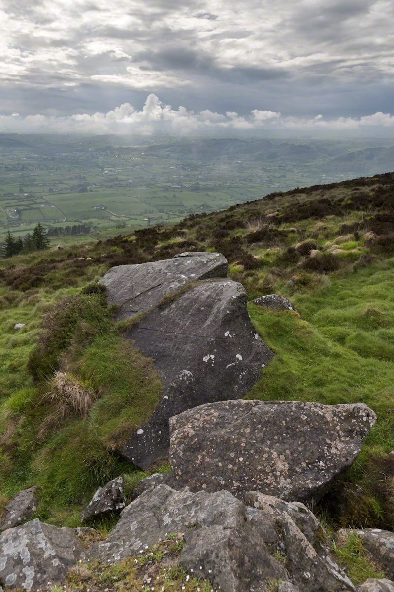
I came upon this rock on June 9, 2014 on a day my cousin Sean Mills invited us to walk the Tain Way over Slieve Foye. It was such a finely shaped piece of what I suppose to be granite, the view of Carlingford, the lough and farmland so compelling, I spent time composing this landscape.
You can make out “King John’s Castle” just over the ridge and its yellow flowering gorse, on the margin of the blue lough. It is the boxy, grey structure; crenellations are visible on high resolution versions of the image. Carlingford is known for the castle, the popular name is for the English monarch who spent time there, although it was built by another.
A hellish shriek assaulted the cold 3 am darkness.
The scream was instantly recognizable. Anything but terrified, after a confused scramble I reinserted the pin into a personal security device hung from my backpack. Wrapped in a silly waffle weave blanket, tossing restless in the cold, the pin lanyard hung up then pulled free. Several minutes had passed with that sound flowing out over the canyon, calling all carnivores to breakfast.
I had drifted off with the wind shaking my tent like a drunken prankster and now all was totally and absolutely quiet. In spite of the cold, the inadequate blanket and the imaginary creatures looking for the source of that scream, the next two hours sped by in a fitful doze.
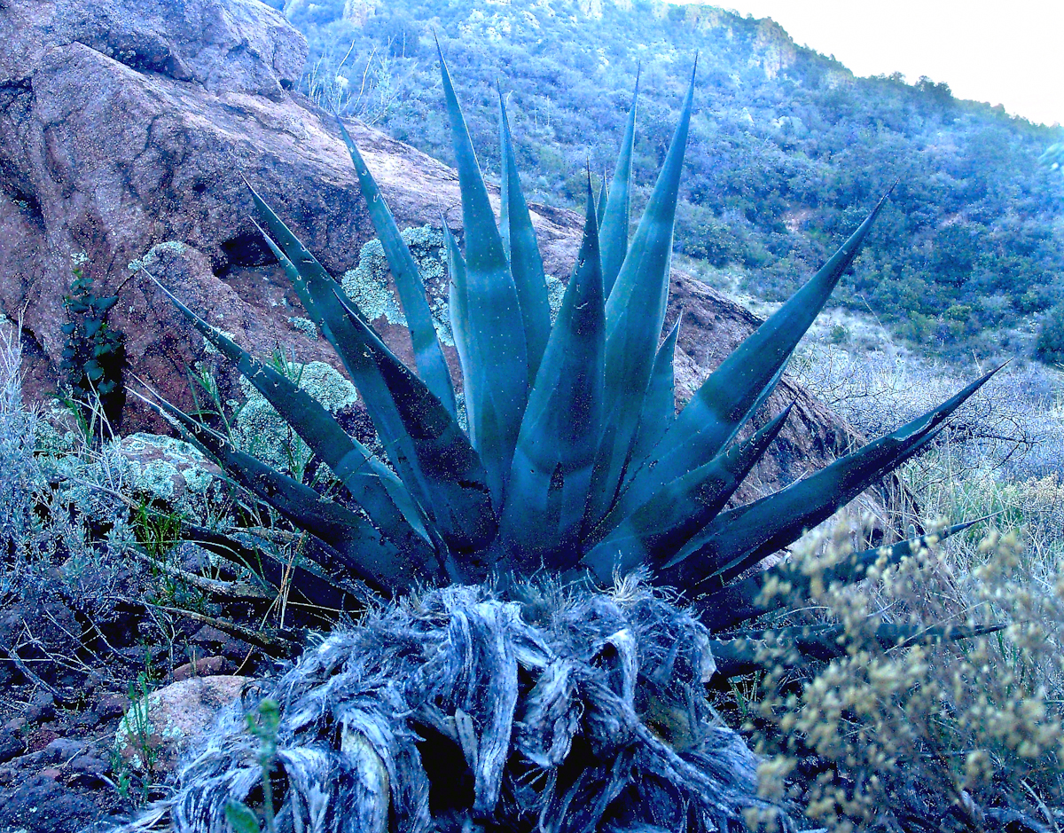
Agave Heart
At 5 am I crawled out to find the thinnest crescent moon imaginable gracing the eastern sky, kept company by a century plant silhouetted against the early dawn light.
Click any photograph for a higher resolution image.
These stalks raise the golden flowers of this agave 10 to 15 feet above the green prickly rosette. Century plant stalks can be seen throughout the Superstitions, even at the high elevations among towering Ponderosa Pine.
Here is an agave in predawn light I caught on the next day, in Pine Creek canyon.
Agave in PreDawn Light
The leaves are used as needle and thread with the very sharp tip as the needle and the long leaf fibers, when properly dried and shredded, as thread. These leaves guard the agave heart from the harvest. A poke from an agave spike can be deep and painful.
The young shoots of the stalks are a succulent delicious treat raw. Roasted, the agave heart is a fresh, somewhat sweet delight. The earliest residents of this desert left numerous roasting pits on the mountain slopes, located where the agave still grows.
Dawn and the Pretty Hedgehogs
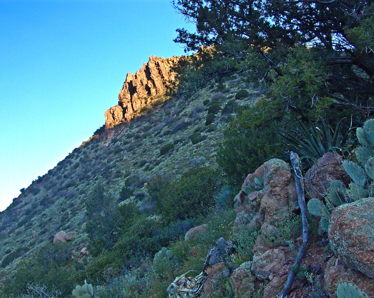
Although cold, the still dry air felt marvelous and even distant objects appeared absolutely clear. In this environment the spread of sun with its rising is a ritual. Here’s a photograph of the canyon walls a few minutes before the sun reached them.
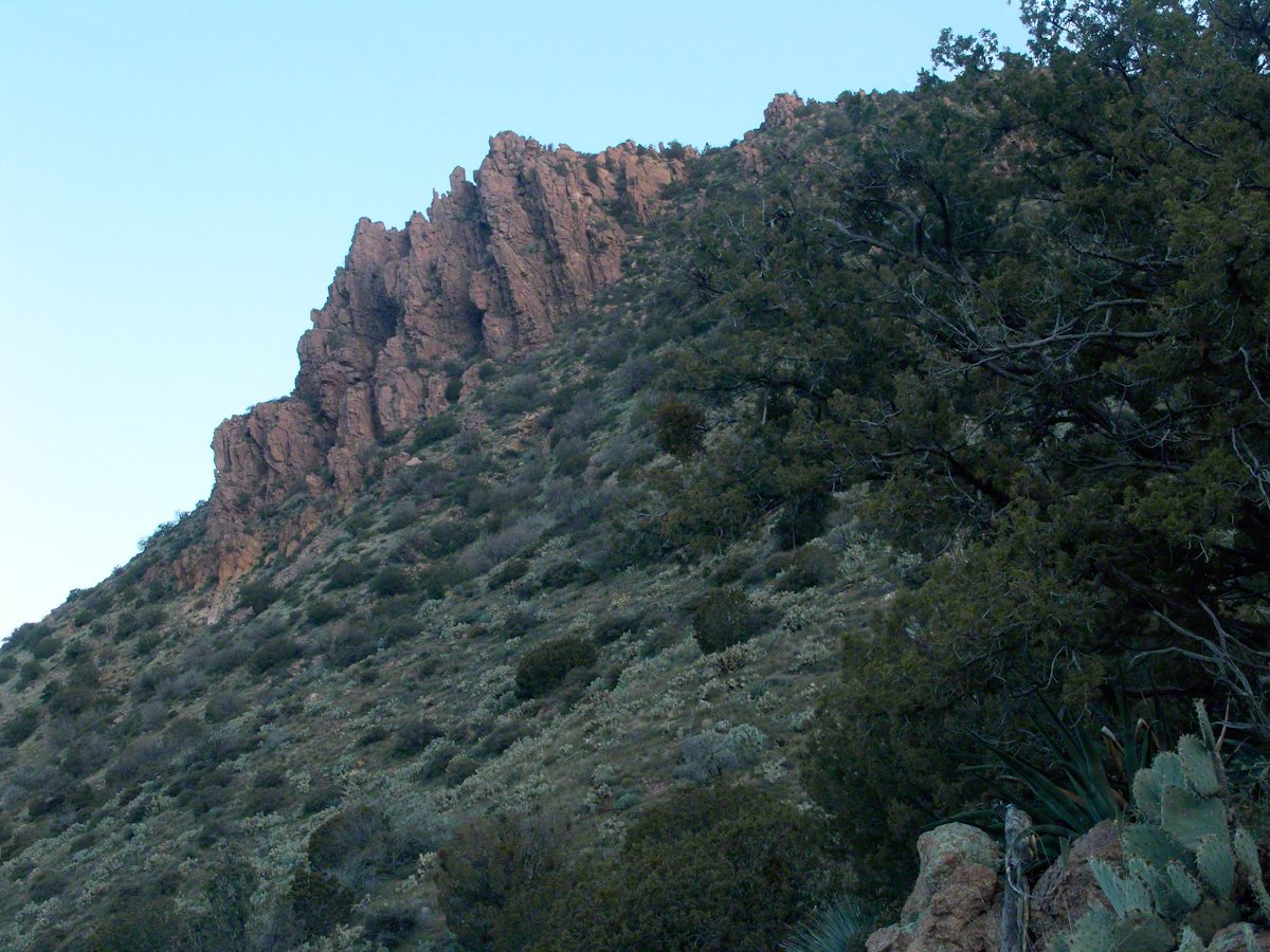
Slopes of Two Bar Mountain in PreDawn Light
And, a few minutes later, as the sun passed the ridges of Two Bar Mountain.…
Dawn on the Slopes of Two Bar Mountain
By the way, that’s a desiccated agave stalk to the lower right, on the rocks.
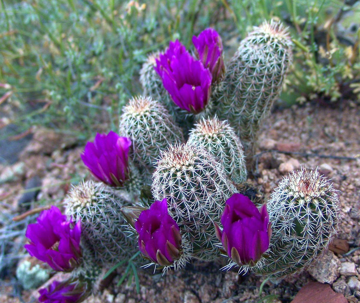
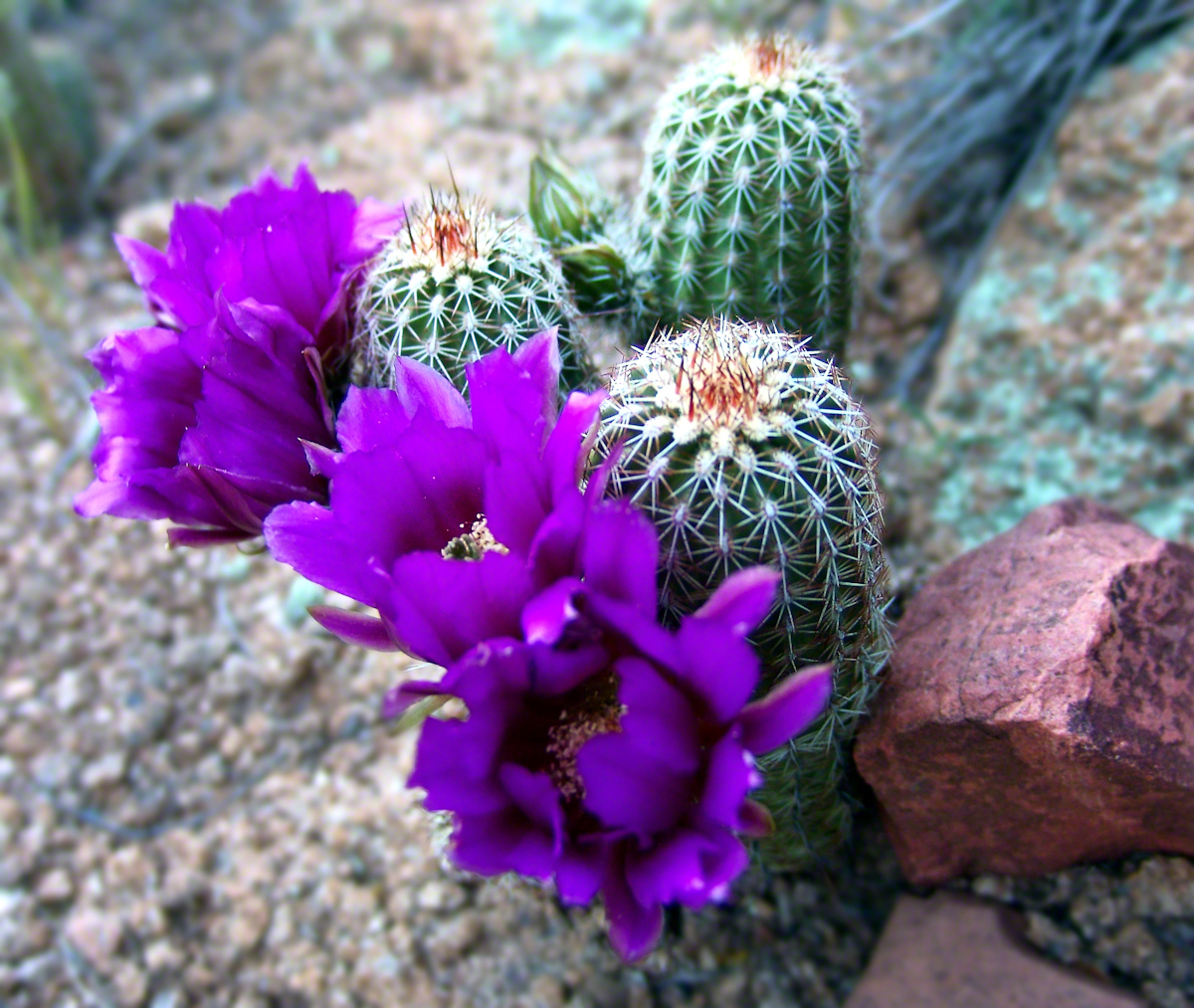
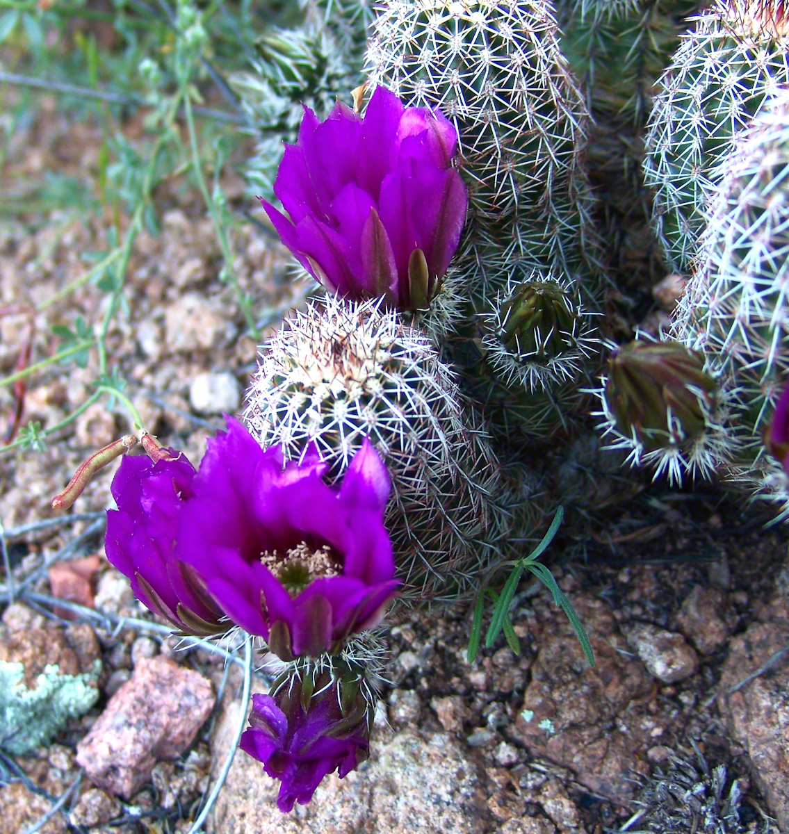
At my feet, spread at intervals on the brown red broken rock, small Hedgehog cacti bloomed lavender.
Lavender Hedgehog BlossomsLavender Hedgehog BlossomsLavender Hedgehog Blossoms with Buds
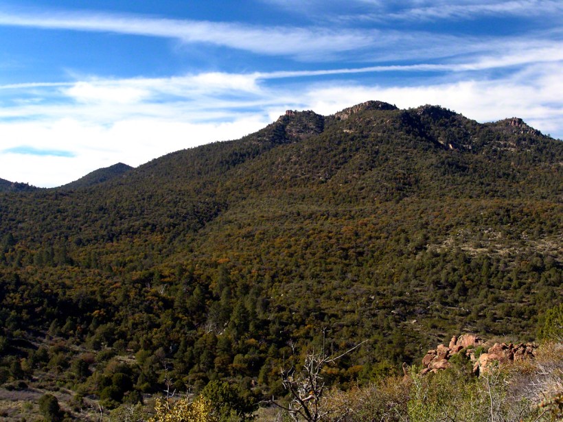
Cacti, such as the blossoming lavender Hedgehog seen above, require a space which enjoys full sunlight for most of the day. The thick grown of juniper trees limited sunlight and compete with the cacti for water. This image will give you an idea of the extent of the juniper growth.
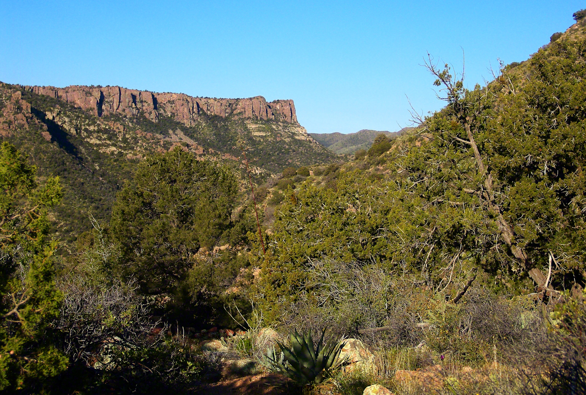
Nameless Canyon in the Dawn
Looking into Nameless Canyon
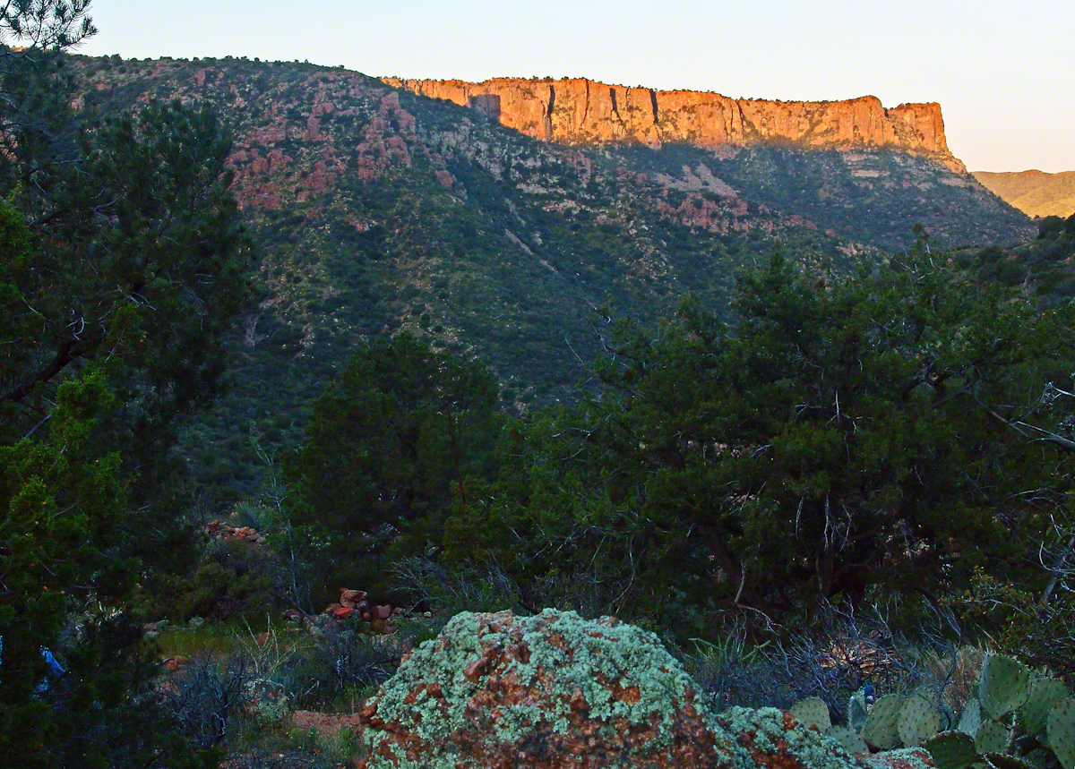
In the above photograph you are looking west over a canyon that is unnamed on maps. The dramatic flat ridge bathed in light is a landmark marking the canyon of Reavis Falls, on the far side in this view. Make your way down the canyon where is joins Reavis Creek, turn left and the falls are a few miles upstream. This is NOT the easiest path to the falls.
As the sun rose I needed to prepare for the day’s trekking, but took one more portrait of this lovely nameless canyon traversed by an almost non-existent path.
Nameless Canyon Morning
This season, a cold stream ran at canyon bottom. Flowing among the rocks the water produced peals of a crystal bell, but this was not my last memory of this place.
In the “Nameless Canyon Morning” image, on the left there is the almost vertical (no exaggeration) canyon wall I climbed in 4.5 hours that morning. It traversed 800 feet altitude in less than a mile. The path was substantially longer because it followed the contour lines of the land in long loops called switchbacks. As I proceeded up the canyon wall, to the southeast, above the opposite canyon wall, the memorable Four Peaks gradually appeared. Here’s the view from my lunchtime perch…..
Four Peaks from Nameless Canyon
This view looks over the basin of Reavis Creek and includes the, out of sight, 140 foot high Reavis Fall, the highest free fall in Arizona.