Torr Head Stories III

Neolithic Passage Tomb

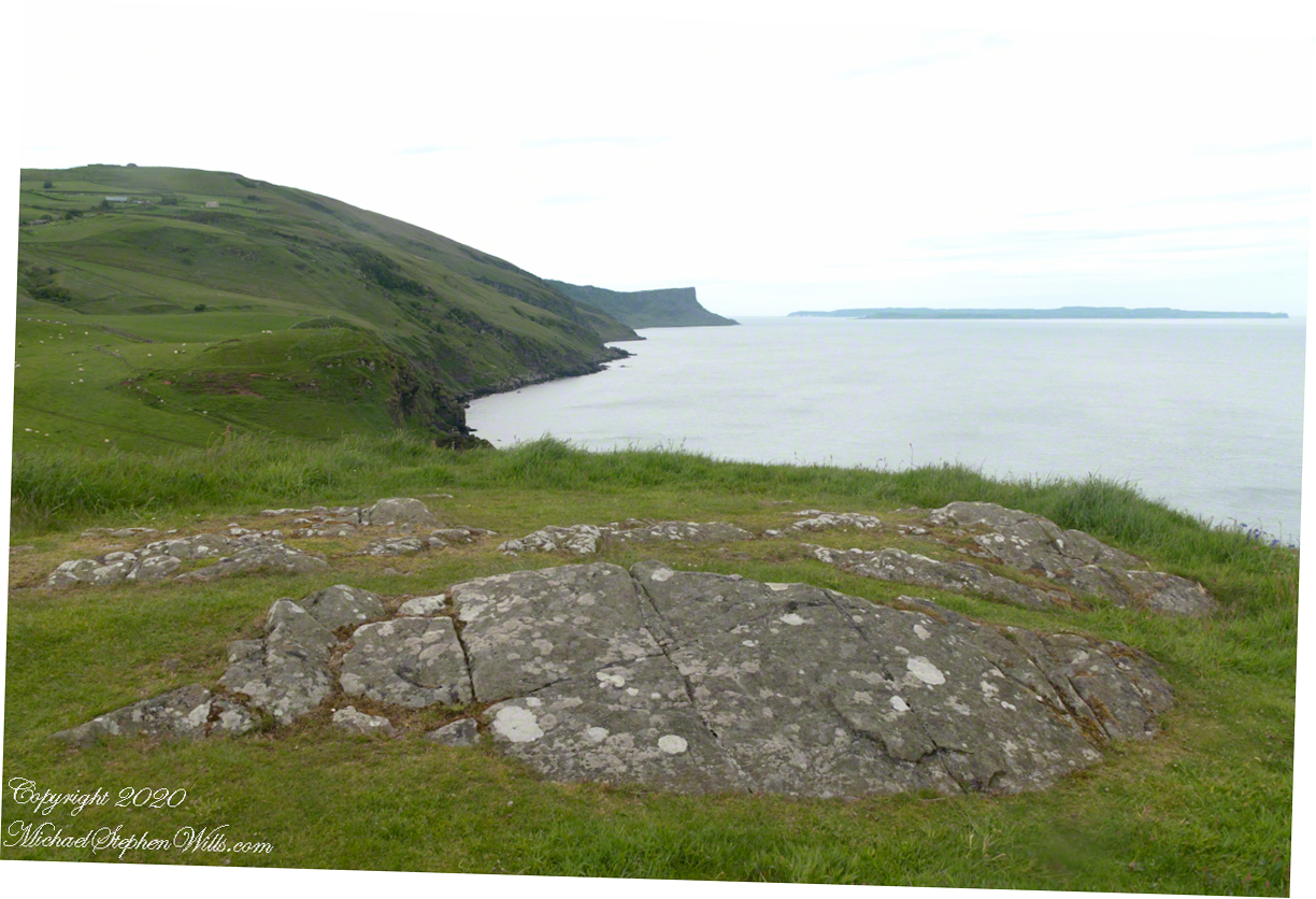
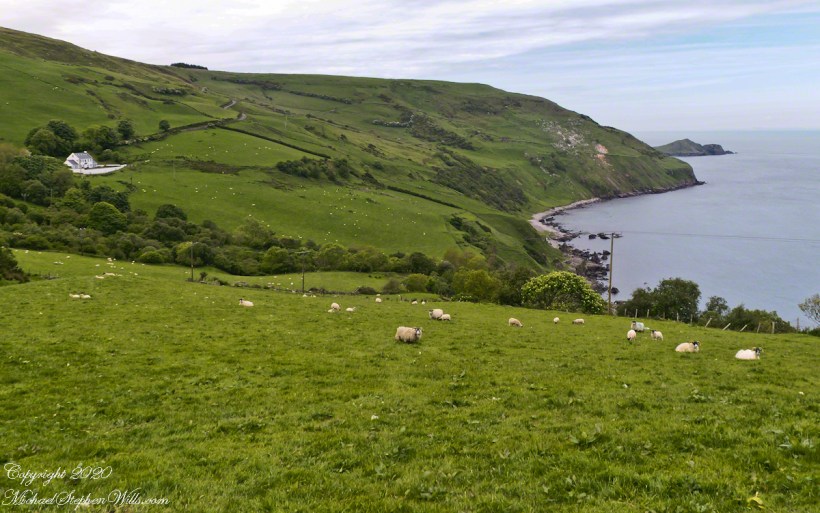
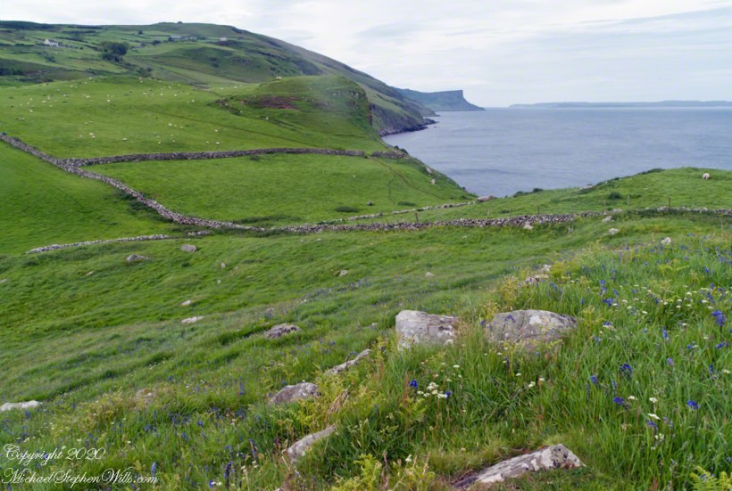
Taking in a flower meadow, foreground, coaster sheep pastures, the photograph, below, looks north from Torr Head. The high hill, midground, is Greenanmore, notable for a the largest passage tomb of the Antrim Glens. Locally known as “Barrach’s Tomb,” for the Red Branch knight of the 1st Century AD fort on Torr Head, tree ring research of the mid-20th Century dates these tombs in the neolithic The hilltop passage tomb was an ancient relic when the mortar of Barrach’s Torr Head fort was drying.

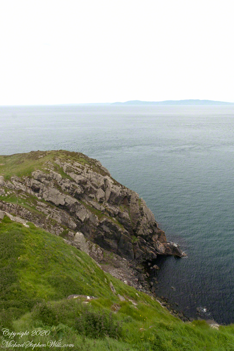
When I enlarge the original photograph, visible on the ridge is a decommissioned Cold War listening post, the tomb is near that. The distant land across the North Channel water is Rathlin Island.

Click photograph for a larger view. To do this from WordPress Reader, you need to first click the title of this post to open a new page.

Click me for the first post of this series.

Copyright 2022 All Rights Reserved Michael Stephen Wills

Torr Head Stories II

Ancient Castles and Raithlin Island

Knights of the Red Branch appear towards the end of “Deirdre and the sons of Uisneach”, a tale from 1st century AD Ireland, as protectors of the lovers Dierdre and one of the sons of Uisneach, named Naoise. The two fled to Rathlin Island, seen in the distance in the following photograph.

From Rathlin Island they passed over the Irish Sea to Scotland where they lived happily for a term of years.

Click me for an earlier Torr Head post “A Bit About Torr Head.”

Barrach’s fort no longer exists, a Coast Guard Station was built over the site. There are other intact ruins on this picturesque coast. Here is one close to the Giant’s Causeway, Dunseverick Castle.

Copyright 2022 All Rights Reserved Michael Stephen Wills

World at our Feet

On Peter’s Mesa

View North / Northwest from Peter’s Mesa. At our feet is a mature Saguaro Cactus towering over Charlebois Canyon, to the right Black Mountain. Bluff Spring Mountain, middle distance, then Black Top Mesa. Flatiron Peak, of the famed Superstition Mountain, is in distance. Photographed from Peter’s Trail on a March afternoon 2008. Superstition Wilderness, Tonto National Forest, Arizona

Bluff Spring Mountain, middle distance, then Black Top Mesa. Flatiron Peak, of the famed Superstition Mountain, is in distance. Photographed from Peter’s Trail on a March afternoon 2008. Superstition Wilderness, Tonto National Forest, Arizona

Click Me for the first post of this series, “Bluff Spring Mountain.

Copyright 2022 Michael Stephen Wills All Rights Reserved

Torr Head Stories I

Mysterious Barrach, Knight of the Red Branch

Torr in Irish is a steep rocky height. Likewise, Corr means odd, uneven, rounder, convex, curved, peaked, projecting, smooth. Combined Torcorr is the townland where we stopped on the Torr Road, halted by our wonder at this sight.

In the distance, Torr Head projects into North Channel, the closest land to Scotland. Following the coast, the cliffs in front of Torr Head are home to numerous sea birds such as Fulmars (family Procellariidae) nad Oystercatchers (family Haematopodiadae). Along the rock beaches next Eider Ducks (genus Somateria). You might see the Common Buzzard (species Buto buteo).

Click photograph for a larger view. To do this from WordPress Reader, you need to first click the title of this post to open a new page.

Click me for an earlier Torr Head post “A Bit About Torr Head.”

In the following photograph Torr Head seen from immediately above. I stand on the ancient site of Barrach’s fort, a knight of the Red Branch. After some internet research I cannot find another reference to this knight, other than the information placard on Torr Head.

Morning / Evening

Can you see the Needle’s Eye?

The eye of Miner’s Needle is clear in both these South / Southeast views from Peter’s Mesa looking across the Music Canyon.

Many wildflowers, sprinkled like stars through the foreground of the morning photograph with Prickly Pear, Cholla and Saguaro cactus. Beware of “Jumping Cholla”, named for its seeming ability to attack passers-by. Another name, “Hanging Chain Cholla”, is more appropriate. Each chain with many hooked barbs is lightly attached to the branch, ready to snag a ride from unwary hikers.

Light rakes across the landscape in the evening photograph, taken from another vantage point on Peter’s Mesa. Miner’s Needle is four (4) miles away “as the crow flies,” i.e., line of sight distance.

Click Me for the first post of this series, “Black Mountain.

Copyright 2022 Michael Stephen Wills All Rights Reserved

A Bit About Coolranny Townland

Neat and tidy

2014, the count of townlands on and around the island of Ireland was 61,098 with most of Irish Gaelic origin predating the Norman invasion, first recorded in 12 century church records. The names have a pride of place reflected in the beauty of the namestones along Torr Road.

Click photograph for a larger view. To do this from WordPress Reader, you need to first click the title of this post to open a new page.

The 82 acres of Coolranny forms a slice of land running from a ridge to Loughan Bay off the North Channel of the Irish Sea across from Scotland.

See this post for a description of wildflowers flowering here in the month of June.

A spic and span cottage on Torr Road, maybe the rectory for the Saint Mary’s Star of the Sea church.

An informative placard.

Here is a slideshow of this post’s images. To visit from WordPress Reader, you need to first click the title of this post to open a new page.
Copyright 2022 All Rights Reserved Michael Stephen Wills

Panoramic

Superstition Glory

View North / Northwest from Peter’s Trail looking back the way we came. Black Mountain on right, Bluff Spring Mountain left with LaBarge Canyon running to the Red Hills center. On a March afternoon 2008.

Click Me for the first post of this series, “Black Mountain.

Copyright 2022 Michael Stephen Wills All Rights Reserved

Autumn Ithaca

Cass Park

Pam and I arrived early to Cass Park for our grandson’s October afternoon soccer match, in time for a 2 mile walk on the generous footpaths. This is my impression of that time, from the IPhone 7’s camera.

A Packed Excursion Boat Under A Stunning Sky

This completes our Sunday afternoon walk around Cass Park, Ithaca, New York.

Copyright 2022 Michael Stephen Wills All Rights Reserved

Hear the Music

Roasted Yucca

Here we are climbing Peters Trail to the eponymous mesa and facing East to Music Mountain. Scattered in the brush are desiccated and live Prickly Pear cactus. Poles of young saguaro cactus like randomly placed telephone poles poke up around the lower slopes.

The first published record of Music Mountain is by Ray C. Howland of Mesa Arizona who sent a letter to “Everybody’s Magazine” that appeared in a feature called “Everybody’s Meeting Place: Where writers, readers and the editor gather for informal discussion,” May 1928, Volume 58, Issue 5, page 173. I reproduce Howland’s letter here with minor editing:

“I am in the deserts and mountains of Arizona most of the time. I go into town once each month for mail and provisions. I meet many things as I ramble around, many strange things, things that are beyond my ability to comprehend. One particular was in my mind as I read your printed thought in the back of Everybody’s. Far in the Superstition Mountains of Arizona, in the deepest, most rugged canyon, there are three caves halfway up a great yellow bluff. In these caves are mud dwellings. There are not the cliff-dwelling as found in other parts of Arizona.

The mud walls of these dwellings were made by people with very small hands. The handprints of these ancient masons remain as though they were made yesterday. Just below these caves a beautiful pool of crystal-clear water lies between grassy banks. Tall ghostlike sycamores grow there in great numbers.
I have camped many times beneath those sycamores. It is a beautiful spot. Such a difference between there and the hot desert that lies fifteen miles to the south.! As one lies there, just at twilight, begins the most wonderful music one could imagine. I have never heard music that could compare to it, vague, elusive at times, then again of greater volume. It is my opinion that no living being could record it.

The music is, I believe, beyond description. It seems to take you out of your moral self and transport you back ages and ages, almost to the beginning of things. For the time being one feels as though he were in another world.
I have often tried to solve this little private mystery. I can’t explain it. I can’t even describe it intelligently.

You will probably say as you read this that is is the wind among the pinnacles, caves, trees, etc. that make this wonder phenomenon. It cannot be, for usually there is no breeze in the mountains at twilight. It is still as a tomb except for that music. Besides when the breeze is blowing at any other hours of the day there is no sound.”

Here is a copy of that issue for you to see for yourselves.

In my photographs the bluffs described by Howland are seen clearly in the distance. During our expedition we were never able to visit the caves, though Dave described the location, caves, and dwellings. On Peter’s Mesa are remains of pits where Apaches and Yavapais gathered hearts of agave to roast. We visited a small cave in the side of Peter’s Mesa showing signs of high heat and possibly used for roasting agave.

Click Me for the first post of this series, “Black Mountain.

Copyright 2022 Michael Stephen Wills All Rights Reserved

From Music Canyon

Down South

Dutchman Trail follows the outflow of two springs along the canyon floor: Music Canyon and LaBarge springs. Here we are climbing Peters Trail to the eponymous mesa and facing south / Southeast, looking down on Dutchman Trail.

This is rough country below Bluff Spring Mountain. Stag Horn Cholla cactus is lower right with Prickly Pear cactus scattered in the brush. Poles of young saguaro cactus are scattered around the lower slopes.

Click Me for the first post of this series, “Bluff Spring Mountain.

Copyright 2022 Michael Stephen Wills All Rights Reserved