As with other members of the family Asteraceae. Thinleaved Sunflowers are composed of ray florets. The scientific species name “decapetalus” is inaccurate on several counts. The flower is composed of 8-12 (not only 10, as in “deca”) of these ray florets, not petals. These ray florets are part of the flower reproductive organs, a flower petal is adjacent to, not a component of, a flowers reproductive parts.
Found growing August 24, 2019 along a sunny trail, The flowers attract many kinds of insects, including bees and butterflies, some of which, such as the painted lady and the silvery checkerspot, use the plant as a larval host. The seeds provide a source of food for birds. Muskrats eat the leaves and stems and use the stems in the construction of their lodges. Here we see a honeybee gathering nectar and pollen.
August 20129, Buttermilk Falls New York State Park, Ithaca, Tompkins County, New York.
Copyright 2023 Michael Stephen Wills All Rights Reserved
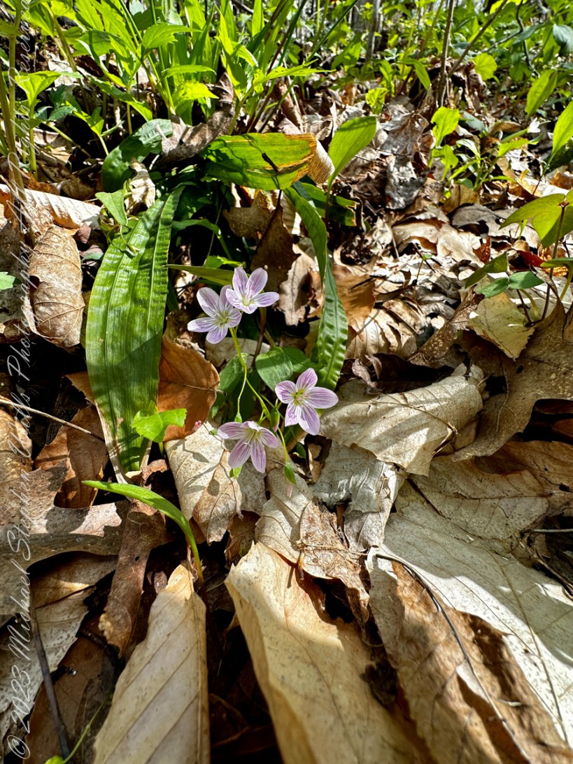
Claytonia caroliniana, the Carolina Spring Beauty, is an herbaceous perennial in the family Montiaceae. It was formerly placed in family Portulacaceae. Its native range is eastern and central North America. It is most found in the New England area of the United States, but its habitat extends from Ontario and a northern limit in the Cape Anguille Mountains of Newfoundland and south to Alabama.
It grows approximately 6 inches tall in forests of the Appalachian Mountains and piedmont.Claytonia caroliniana is a flowering, woodland perennial herb. It grows from March though June and is one of the earliest spring ephemerals. The plant grows from spherical underground tubers in light humus. They sprout and bloom before the tree canopy develops. Once the area is shaded, the plants whither leaving only the tuberous roots underground.
The flowers consist of five pink and purple petals. Dark pink veins accent the petals and give them a striped appearance. The carpels are fused together. I have heard the flowers are white when first opened, have not experienced this myself. They grow on a stem 3 – 10 inches tall that bears a single pair of broad leaves. There are two green leaves that grow opposite each other on a node. The leaf has no teeth or lobes and a prominent central vein. They grow up to three inches long and 1/2 to 3/4 inches wide.
In the photograph, Carolina Spring Beauty flowers bracket the leaves just visible under leaf litter.
Edible
The plant is edible, but its usability is limited due to difficulty harvesting and the small quantities each plant produces. Its tuberous roots are edible and rich in starch and can be cooked or eaten raw. The leaves can be eaten as well. The tuberous roots are eaten by eastern chipmunks and white-footed mice.
History
The plant was named after John Clayton. Clayton was an early collector of plant specimens.
Source: Wikipedia”Claytonia caroliniana. Direct quotations are in italics.
Copyright 2023 All Rights Reserved Michael Stephen Wills
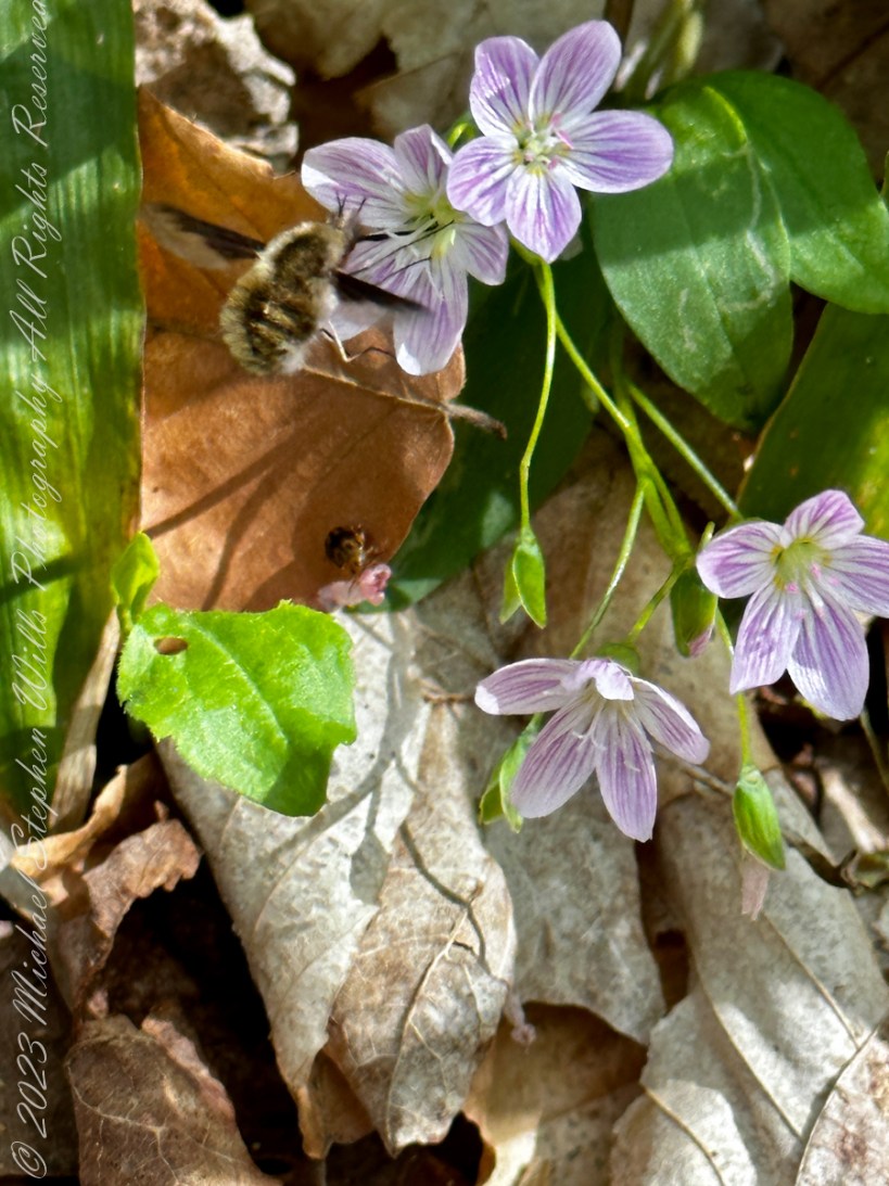
Bombylius major (commonly named the large bee-fly, the dark-edged bee-fly or the greater bee fly) is a parasitic bee mimic fly. Bombylius major is the most common type of fly within the Bombylius genus. The fly derives its name from its close resemblance to bumblebees and are often mistaken for them.
Bombylius major exhibits a unique flight behavior known as “yawing” and plays a role in general pollination, without preference of flower types. The fly does not bite, sting, or spread disease. However, the fly uses this mimicry of bumblebees to its own advantage, allowing close access to host solitary bee and wasp nests to deposit its eggs. After hatching, the larvae find their way into the nests to parasitically feed on the grubs.
Flight
It has been discovered that the fly is capable of a unique behavior, which was discovered with the use of a high speed camera. In this behavior, the flies are seen to rotate around a vertical axis as they fly (this action is known as “yawing”). However, it is still unknown what can cause this behavior to be triggered and what purpose it serves, but a proposed explanation includes mating habits. Here is an illustration of “Yaw” in the context of an airplane…substitute the fly body with head facing forward (to left).
The Bombylius major bee-fly is a common, generalist floral pollinator, meaning that it does not give preference to one flower over another, instead pollinating a wide variety of plant families and species. The fly uses its proboscis to carry and transfer the pollen. The species is a dominant pollinator within its community, sometimes even pollinating up to two thirds of the local flowers. In addition, Bombylius major will visit and pollinate plants that attract few other species. Some types of flowers, for example Pulmonaria officinalis, will be almost exclusively pollinated by Bombylius major, with other species contributing a negligible amount to that plants pollination. Some flower species, such as Delphinium tricorne, are even specifically adapted to the fly in terms of color, shape, and form. If given the choice, Bombylius major will have a consistency in plant choice.
Flower Attraction
Long distance floral attraction is governed by optical sense, with color being the most important factor. The flies are typically more attracted to blue and violet colors, and occasionally yellow, over orange and pink. However, short distance floral attraction is based on the fly’s olfactory sense.
Sunbathing Activity
The fly is mostly active during day hours when the weather conditions are warm and sunny. Bombylius major is attracted to sunnier places and is more likely to pollinate these areas, with a larger average of flower visits in areas of higher amounts of sunshine. The fly will hide in the trees during the night and usually dart away from a cast shadow and occasionally hide in clean washing brought in fresh from the washing line and fly out causing unsettled behavior in the discoverer.
Flower Description
Claytonia caroliniana is a flowering, woodland perennial herb. It grows from March though June and is one of the earliest spring ephemerals. The plant grows from spherical underground tubers in light humus. They sprout and bloom before the tree canopy develops. Once the area is shaded, the plants whither leaving only the tuberous roots underground.
The plant is edible, but its usability is limited due to difficulty harvesting and the small quantities each plant produces. Its tuberous roots are edible and rich in starch and can be cooked or eaten raw. The leaves can be eaten as well. The tuberous roots are eaten by eastern chipmunks and white-footed mice.
Source: Wikipedia “Bombylius major ” and “Claytonia caroliniana. Direct quotations are in italics.
Copyright 2023 All Rights Reserved Michael Stephen Wills
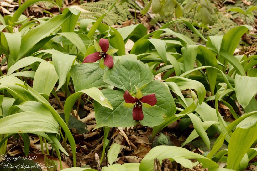
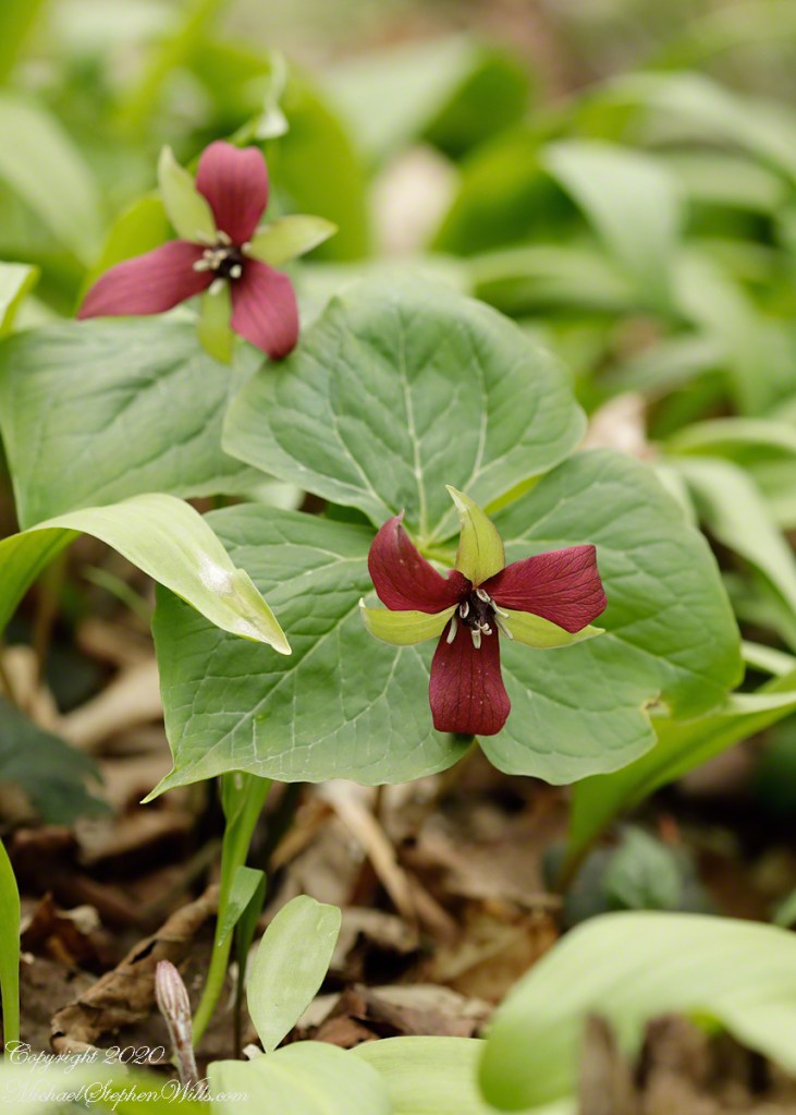
Purple Trillium, a different species from the white, present different challenges. The purple blooms tend to dip down toward the ground. White flowers face upward toward the sky. My successful photographs of purple (Click me for another Purple Trillium posting) have the camera lower than the plant, say where there is a bank above the trail.
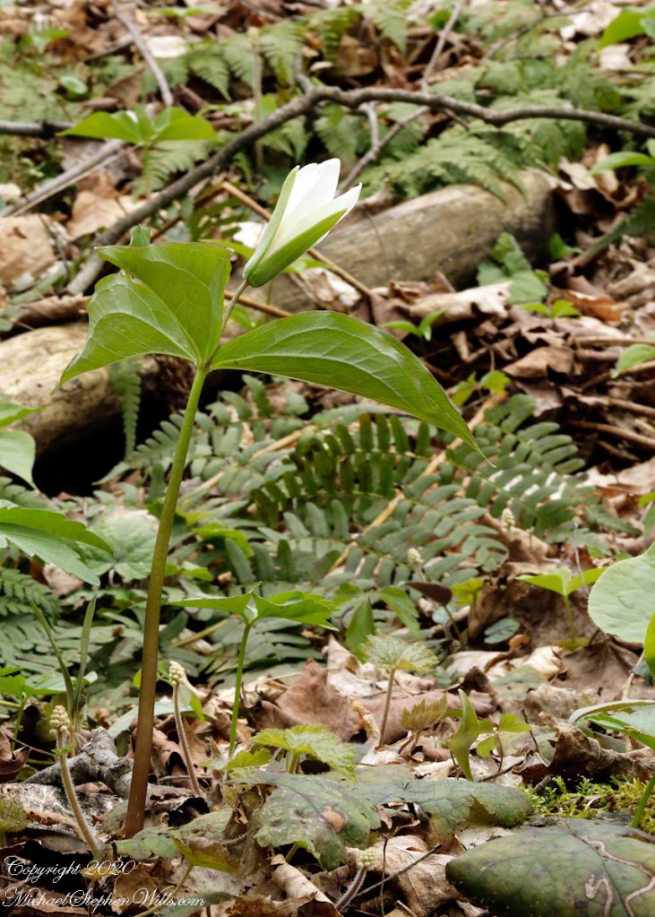
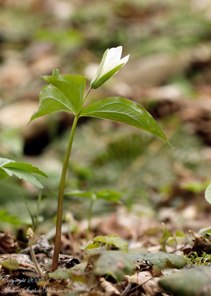
Shot from beneath, White Trillium project a hopeful air. Here is a comparison of the two species in the environmental and individual treatments.
Click photograph for larger image. To do this from WordPress Reader, you need to first click the title of this post to open a new page.
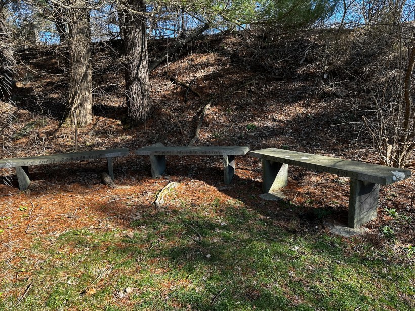
Pam and I ambled around the Arboretum for our Easter 2023 outing. We found a path new to us, with this memorial stone bench, a biblical quote engraved on the seats. Biblical Quote on bench: “What doth the lord require of thee / but to do justly and to love mercy / and to walk with thy god.” Micah 6:8
The Book of Micah is the sixth of the twelve minor prophets in the Hebrew Bible. Ostensibly, it records the sayings of Micah, whose name is Mikayahu (Hebrew: מִיכָיָ֫הוּ), meaning “Who is like Yahweh?”, an 8th-century BCE prophet from the village of Moresheth in Judah (Hebrew name from the opening verse: מיכה המרשתי). The book has three major divisions, chapters 1–2, 3–5 and 6–7, each introduced by the word “Hear,” with a pattern of alternating announcements of doom and expressions of hope within each division. Micah reproaches unjust leaders, defends the rights of the poor against the rich and powerful;[ while looking forward to a world at peace centered on Zion under the leadership of a new Davidic monarch. While the book is relatively short, it includes lament (1.8–16; 7.8–10), theophany (1.3–4), hymnic prayer of petition and confidence (7.14–20), and the “covenant lawsuit” (6.1–8), a distinct genre in which Yahweh (God) sues Israel for breach of contract of the Mosaic covenant.
All photography using the IPhone 14 ProMax triple camera, raw format, edited on the phone.
In the quote tract, (6:6–8), Micah speaks on behalf of the community asking what they should do in order to get back on God’s good side. Micah then responds by saying that God requires only “to do justice, and to love mercy, and to walk humbly with your God.” Thus declaring that the burnt offering of both animals and humans (which may have been practiced in Judah under Kings Ahaz and Manasseh) is not necessary for God.
Reference: “Micah” Wikipedia
Copyright 2023 Michael Stephen Wills All Rights Reserved
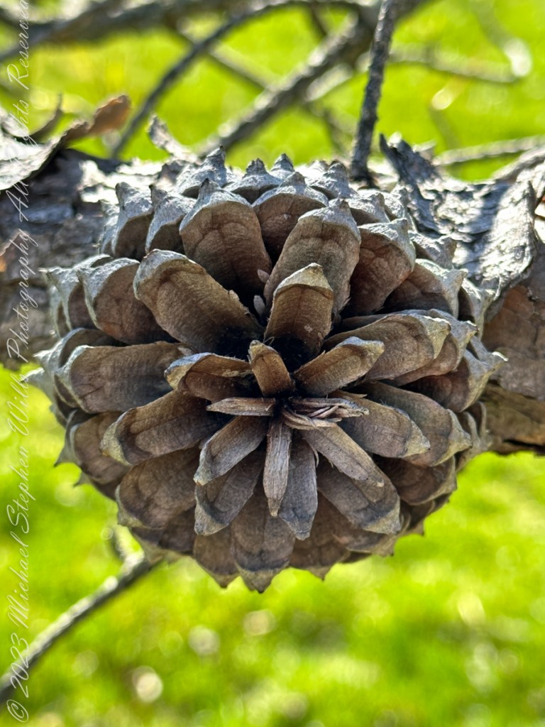
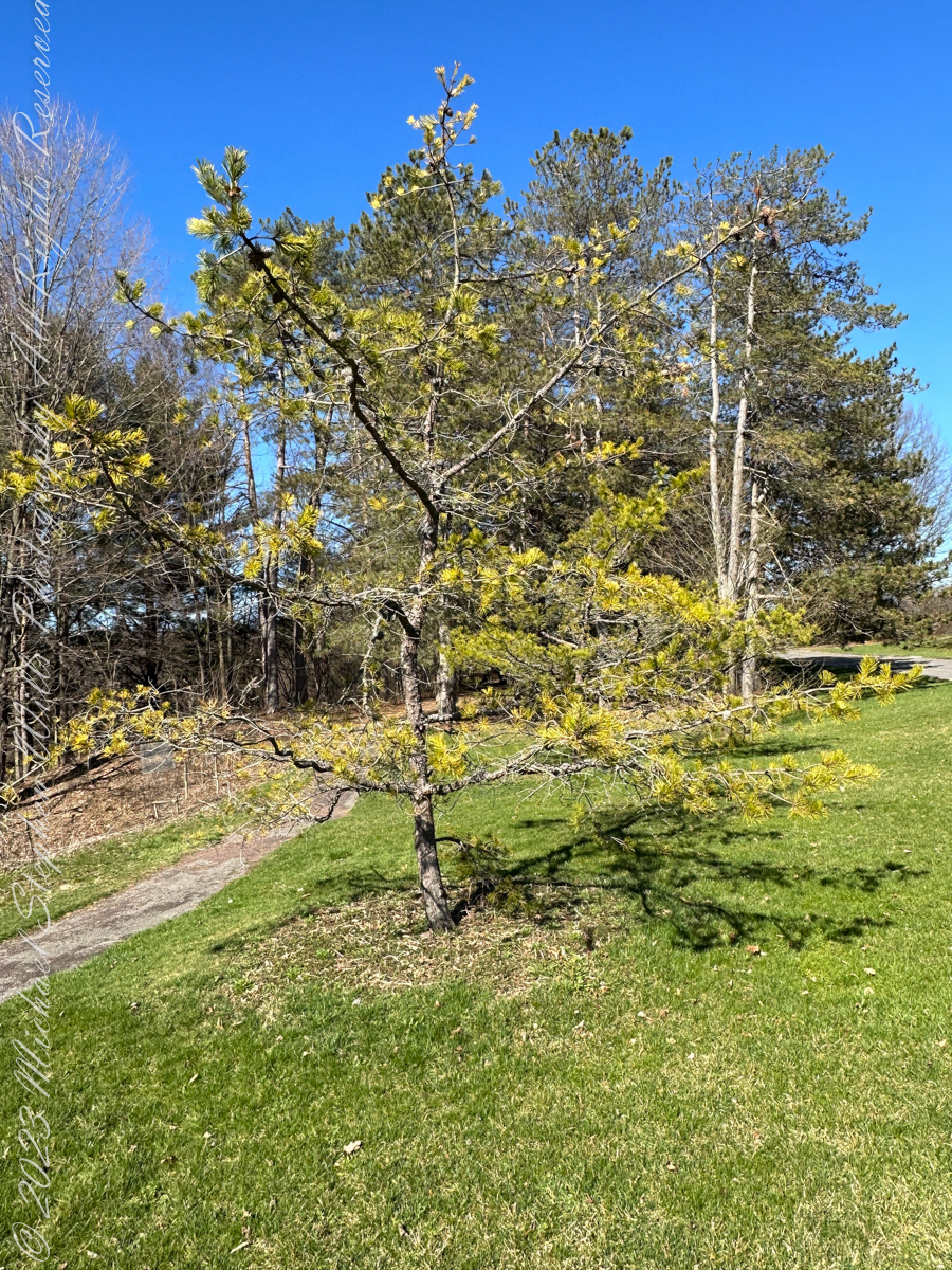
Pam and I ambled around the Arboretum for our Easter 2023 outing. Found here growing outside native range, being the Appalachian Mountains from Georgia to southern Pennsylvania, the Table Mountain Pine is named after the landform, not a particular mountain.
All photography using the IPhone 14 ProMax triple camera, raw format, edited on the phone.
Its pinecones drew me to this scraggly, ungainly, poorly formed tree. All general mankind finds useful in the, scientific name, Pinus pungens, otherwise known as Hickory Pine, Prickly Pine and Mountain Pine, is to grind it up for pulp or chop it for tinder.
Last of the Mohicans
That said, the final scene of the 1992 film The Last of the Mohicans takes place in a nice Pinus pungens stand on a rocky mountaintop in North Carolina.
Personality
The tree has personality. Pinus pungens is the Lonesome Pine of the 1908 novel The Trail of the Lonesome Pine by John Fox, and popularized in the Laurel and Hardy film Way out West: “On the Blue Ridge Mountains of Virginia On the Trail of the Lonesome Pine” Several “Lonesome Pine” hiking trails have been waymarked in the Blue Ridge Mountains and elsewhere in the Appalachians.
Pinecone Bud
Pinus pungens prefers dry conditions and is mostly found on rocky slopes, favoring higher elevations, from 300–1,760 meters (980–5,770 ft) altitude. It commonly grows as single scattered trees or small groves, not in large forests like most other pines, and needs periodic disturbances for seedling establishment. The three tallest known ones are in Paris Mountain State Park, South Carolina; they are 26.85 to 29.96 meters (88 ft 1 in to 98 ft 4 in) tall.
Reference: “Pinus pungens” Wikipedia.
Copyright 2023 Michael Stephen Wills All Rights Reserved
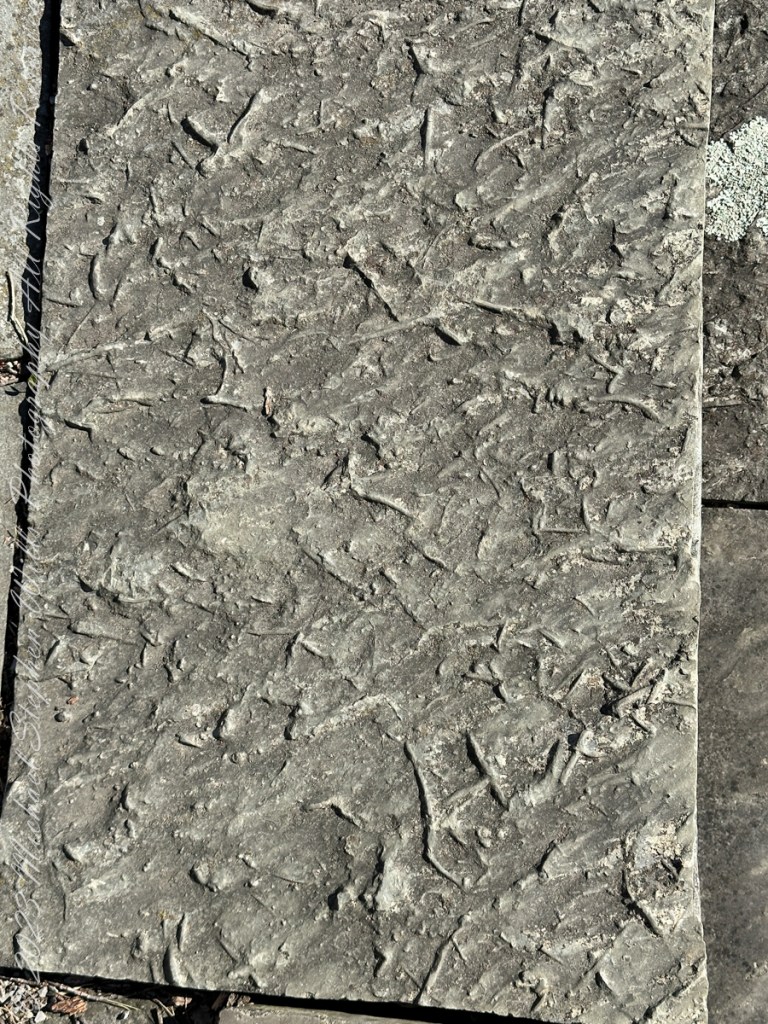
Pam and I ambled around the Arboretum for our Easter 2023 outing. A type of sandstone popular with Cornell monument builders, called “Lenroc” after a mansion build by Cornell’s founder, was used for these benches built into the hillside of the FR Newman Arboretum. The views are more interesting than the bench, the arch of stone in midground in one photo.
All photography using the IPhone 14 ProMax triple camera, raw format, edited on the phone.
The stone is mined locally from surrounding hills. Calling it “Lenroc” (Cornell spelled backward) is a misnomer as the stone is mined widely throughout the region.
Feldspathic Greywacke
“Bluestone from Pennsylvania and New York is a sandstone defined as feldspathic greywacke. The sand-sized grains from which bluestone is constituted were deposited in the Catskill Delta during the Middle to Upper Devonian Period of the Paleozoic Era, approximately 370 to 345 million years ago…..
Glacial Landscape on an early spring day, Easter 2023
Textures
…The Catskill Delta was created from runoff from the Acadian Mountains (“Ancestral Appalachians”). This delta ran in a narrow band from southwest to northeast and today provides the bluestone quarried from the Catskill Mountains and Northeastern Pennsylvania. The term “bluestone” is derived from a deep-blue-colored sandstone first found in Ulster County, New York.”
You can feel the origin of this bluestone from these macros of two pavers from a monument bench.
Reference: “Bluestone” Wikipedia.
Copyright 2023 Michael Stephen Wills All Rights Reserved
About 700 years ago, when the expansion of the Mongol empire was under way, on the other side of the planet people discovered a series of caves, formed in tuff, with a favorable location in a south facing cliff near water. Tuff, a rock formed from volcanic ash, is hard, brittle and soluble in water. From these properties this series of caves formed. The southern exposure provided excellent climate control for people, like those we now call the Salado, who understood how to exploit the location.
They constructed from local materials (mud, plants and rock) rooms in the upper cave just far enough inside to be warmed by the winter sun and protected during the summer when the sun’s sky-path was higher. Who knows how long the Salado lived in what must have been this paradise or why they left.
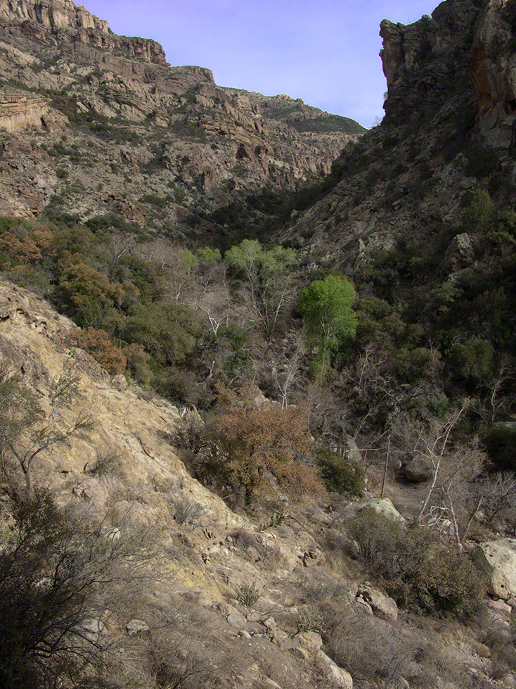
In March 2006, after returning from a nine-day backpack trip to the remote eastern Superstition Wilderness I used a four-wheel vehicle to reach the Roger’s Trough trailhead for a day trip to this site in Roger’s Canyon. The advantage of Roger’s Trough is the high elevation that leaves “just” about 1,100 feet of climbing (2,200 total) for the day. As it happens, it is downhill to the ruins though there is plenty of ups and downs plus scrambling over rocks.
I started late morning and a returning party met me on the way out and warned against leaving packs unattended. It seems they were victimized by pack rats. My timing was lucky and I had the site to myself.
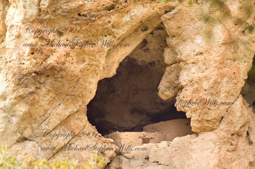
First (refer to the “Roger Canyon” photograph, above) I climbed the cliff opposite from the ruins to set up a tripod an telephoto lens to shoot through the trees to capture the main building inside that very interesting looking tuff (see below). That central column (to the right) divides the cave opening and there are views from inside, up and across the canyon. In season, the cliffs are occupied by nesting birds and, higher up, there are fascinating caves in locations too high and steep to reach without the proper equipment.
As it is, climbing into the upper cave requires an exposed rock scramble. By “exposed” I mean the climber is exposed to falling. That is an intact wooden lintel of the visible structure opening and the larger structure, to the right, has curved walls.
Salado Cave Ruin
I then explored in and around the site. The location of a lower cave made it useful for storage, it was walled off and the sturdy structure still stands today. By the way, I inverted this view for artistic purposes.
Lower Storage Room
A lower cave is opened and accessible. Looking out, I felt the original inhabitants were with me and then a raven started calling over and over and over.
Lower Cave
I was so fascinated by the possibilities of the site that time got away from me until this incessant cawing of a raven made me notice the lengthening cliff shadows. Here is a view (see below) of my way home, back up Rogers Canyon. My last shot before packing up. It took just over two hours to get out, at a steady pace. It was twilight as I approached the Rogers Trough trail head.
By the way, my posting before this one (“Finding Circlestone”) includes a shot of White Mountain. In that view, these ruins are on the other side of White Mountain.
View up Rogers Canyon from the Ruins
Copyright 2023 Michael Stephen Wills All Rights Reserved
I first learned about Circlestone from stories The Searcher told during my first backpack into the eastern Superstition Mountains, on the Tule trail, April 2005. I described this in “Riding from Pine Creek to the Reavis Valley” where the Searcher described a stone circle, overgrown with Alligator Juniper, on the slopes of Mound Mountain. He pointed south toward a peak and foothills that rose from the valley floor and said, “follow the fire trail east from the southern Reavis Ranch valley.” There were strange happenings associated with Circlestone (as he called it) and he’d never taken the time to go there. “There is a book full of stories.” I eventually sought out Circlestone on the web and in books, but after I found it on my own using only the Searcher’s directions and advice from friends met on the way.
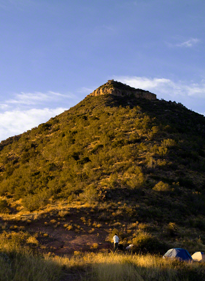
Sunset from Castle Dome
Backpacking with my sister
In 2006 I explored Circlestone twice along with my sister, Diane, who accompanied me. First for nine days early March 2006 using the Reavis Ranch trail from the north and the second for five days in November 2006, coming us the same trail from the south. Our first trip was Diane’s first “real” backpack adventure and we took it slow with a camp at Castle Dome where there are flat areas and exceptional views. Above, is the sunset from our second night (I camped the first night next to the car…we took it very, very sloooowwww).
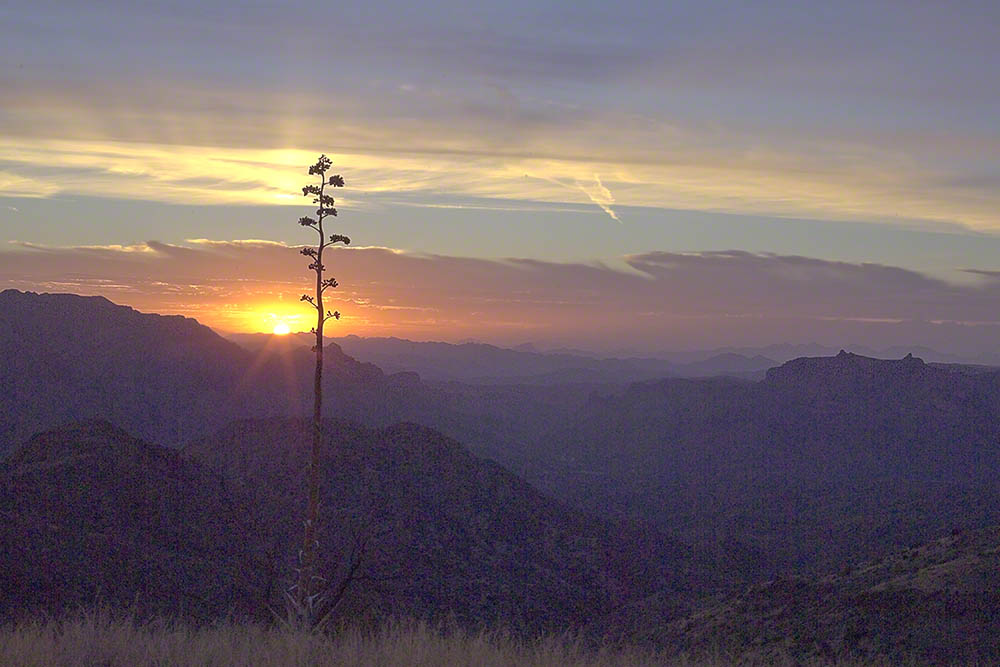
Four Peaks Sunrise
Castle Dome
Then, there was morning of our third day. Here is the Four Peaks Wilderness in the first rays of dawn. These are green, rolling foothills of grass, low shrubs and a few juniper. If you know where to look, there’s an unmarked trail to Reavis Falls (the highest waterfall in Arizona). I found the trail and visited the falls on a later trip.
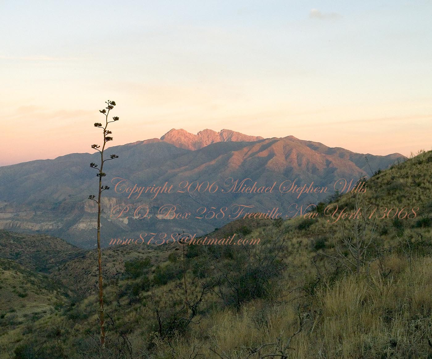
Castle Dome Sunrise
After enjoying the Four Peaks, you turn around and see Castle Dome in the morning light, as in this photograph. Remember the same of the “dome”, because it is visible from the ultimate view from Circlestone.
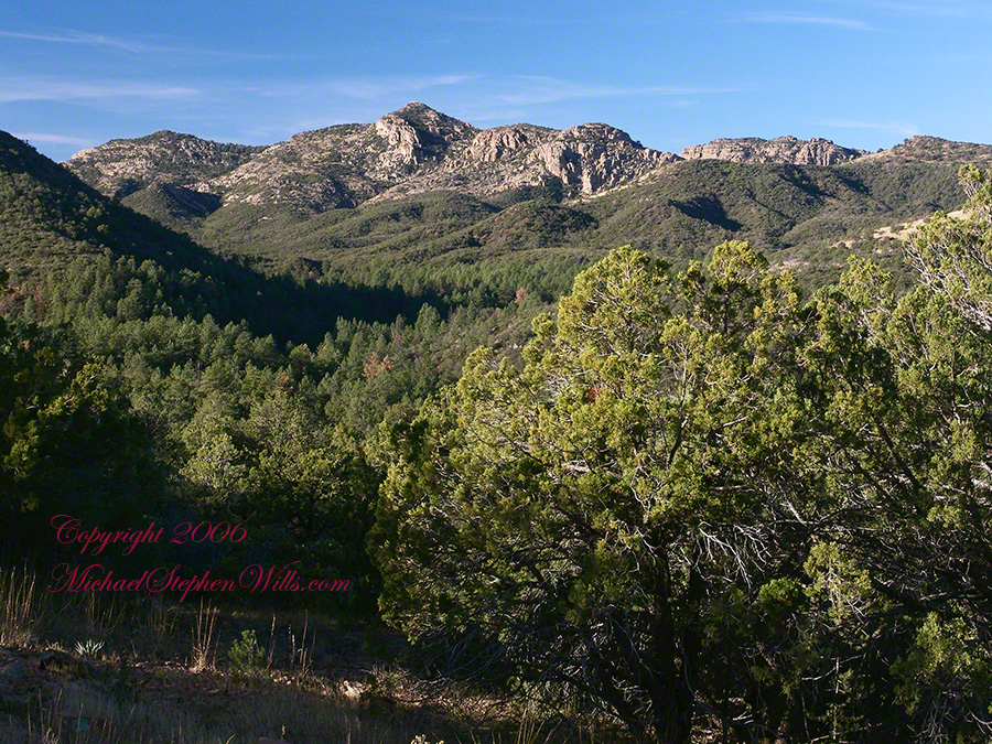
Reavis Valley and White Mountain from the trail to Circlestone
The Trail to Circlestone
Our camp was in the Reavis Valley, one of the first sites along the creek coming from the north. There were fantastic rock formations across the creek. Not far from there, the land falls away into steepness and then Reavis Falls. The Searcher told me about going that way, once. There is no trail down to the falls overlook and deep canyon carved by the water.
This photograph, above, is from a lovely forest of pinyon trees that grow along the trail to Circlestone (described by the Searcher as rising from the southern Reavis Valley). You can see the valley, just to the right, and a longer and steeper valley that rises from it up to White Mountain. That way is the southern legs of Reavis Trail. I have a movie clip from this same spot of the pinyons moving in the breeze and may post it at a later time.
All of the trail to Circlestone is a climb. You pass over “Whiskey Spring”, named for a still kept there in the 1800’s and over a steep defile gouged from the rock. The trail is well marked and I am told that, sometimes, there is no cairn marking the trail to Circlestone. If you are desperate to get there, look-up some excellent hiking directions available on the web. I have even found the circle on GoogleEarth, since I know where to look. If you like a challenge and the adventure, go from the directions the Searcher gave me.
Four Peaks from Circlestone
From the fire line trail, the unmarked branch to Circlestone climbs steeply and follows a ridge through Alligator juniper, punctuated by stalks of century plant, to a broad way that rises to Circlestone as though to a monument overgrown by the same juniper.
My Circlestone Mystery
There was an unusual experience on our first trip, on this portion of the trail. We were winding through the Juniper and, as it happened, Diane fell behind. After awhile I missed her and waited and, after a minute, went back to look for her. I found Diane sobbing uncontrollably, deep in grief over our father who passed away eleven years before. We talked about it until she felt better. She said it was as though a door opened and she could feel out father. What makes this exceptional is Diane is not given to anything like this and I ascribe her deep grief to the nature of the site. It is a mystery to this day.
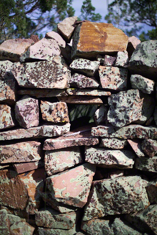
At Circlestone, that first trip, we explored and experienced the site. You cannot see the entire wall at any point and need to wander through and over it, being careful not to disturb anything. Here and there, in the outer wall, are openings like the one in this photograph.
Site-Hole in the Circlestone Wall
At Circlestone
I call it a site hole because, on your knees, it is possible to look through and see the distant view through the trees. As you can see, the stones are a striking red color with green lichen growing thick.
On the second trip in November, knowing the way and having great weather, I brought my cameras to capture the exceptional views, one of which is above. I’d dearly love to come back to camp just below the ruin and do some work in the evening and morning light. For now, I can enjoy those views from Castle Dome.
Three Horsemen and Castle Dome
Can you see the dome in the middle distance. I did a portrait of three horsemen who road up to Circlestone in November. We came to know them pretty well, that afternoon and the following morning down in the valley.
Three Horsemen
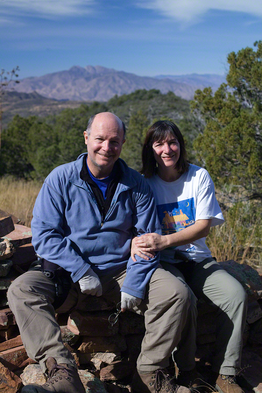
I carted up a tripod, so you can see Diane and I in the same spot.
Mike and Diane at Circlestone
Copyright 2023 Michael Stephen Wills, All Rights Reserved
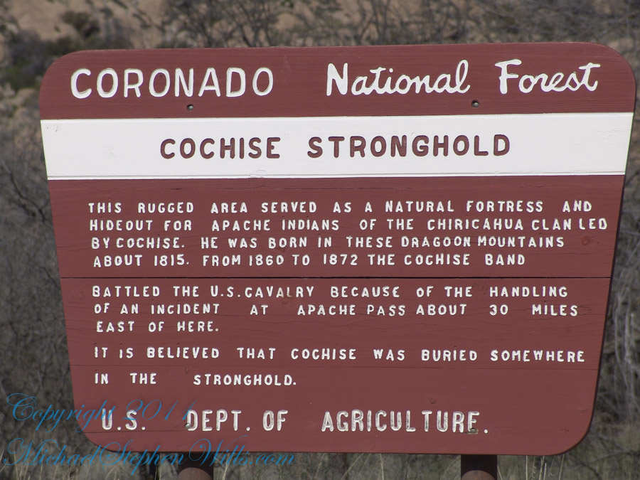
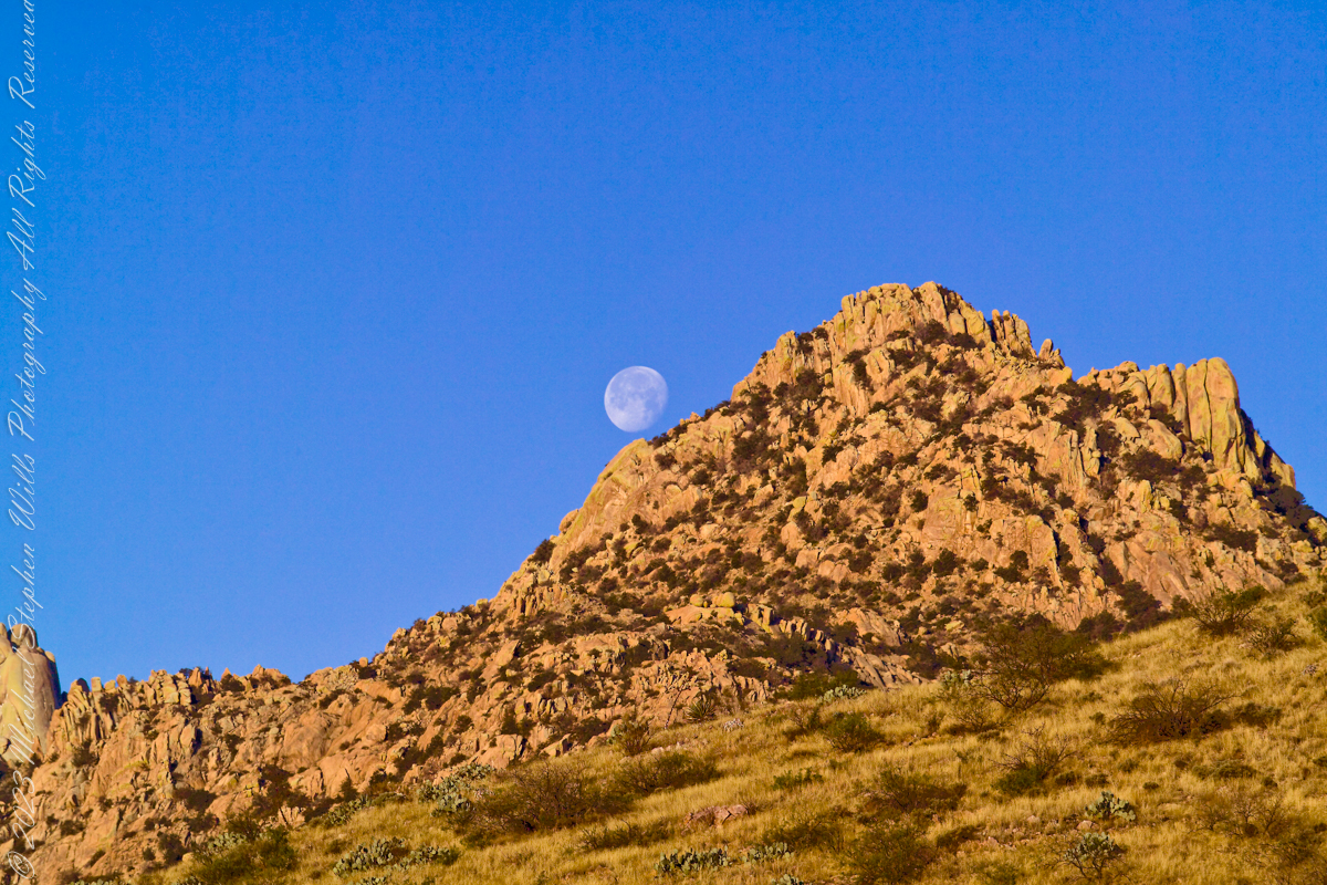
Interstate 10 between Benson and Wilcox ascends through a field of enormous, eroded granite boulders. Off to the west are the Dragoon Mountains, otherwise known as “Cochise Stronghold.” This rugged area served as a natural fortress and hideout for Apache Indians of the Chiricahua clan led by Cochise. He was born in this Dragoon Mountains about 1815. From 1869 to 1872 the Cochise band battled the U.S. Calvary because of the handling of an incident at Apache Pass about 30 miles east of here. It is believed that Cochise was buried somewhere in the Stronghold.
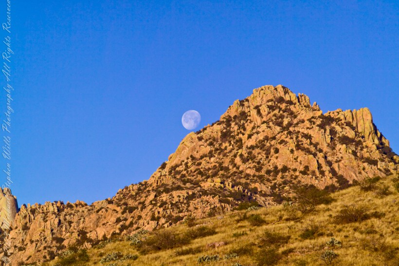
One April morning, very early, on the road to Cochise Stronghold. We stopped everything for me to unload the equipment to capture a gibbous moon low in the west, grazing a hoodoo ridge of Cochise Stronghold of the Dragoon Mountains. Near Dragoon, Cochise County, Arizona
Copyright 2023 Michael Stephen Wills All Rights Reserved