In more recent centuries Loughcrew became the seat of a branch of the Norman-Irish Plunkett family, whose most famous member became the martyred St Oliver Plunkett. The family church stands in the grounds of Loughcrew Gardens. With its barren isolated location, Sliabh na Caillí became a critical meeting point throughout the Penal Laws for Roman Catholics. Even though the woods are now gone an excellent example of a Mass Rock can still be seen on the top of Sliabh na Caillí today. The Plunketts were involved in running the Irish Confederacy of the 1640s and were dispossessed in the Cromwellian Settlement of 1652. Their estate at Loughcrew was assigned by Sir William Petty to the Napier Family c.1655. The Napiers are descended from Sir Robert Napier who was Chief Baron of the Exchequer of Ireland in 1593.
Cairnbane East in Ireland, part of the Loughcrew Cairns complex, combines historical significance and folklore, particularly about a witch shaping these megalithic structures.
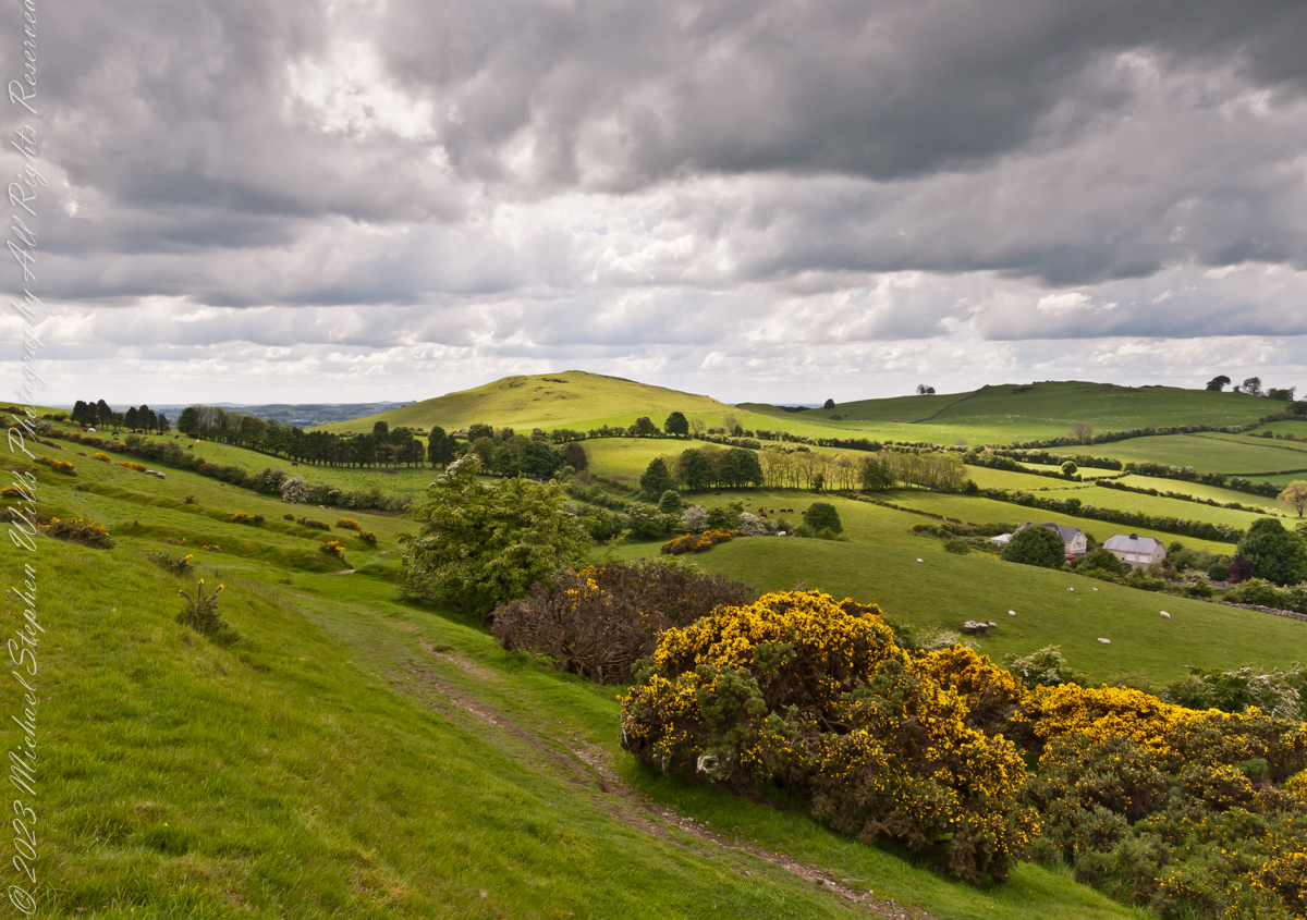
Here we are looking south, southwest from the north side of Slieve na Calliagh (aka Cairnbane East) toward Cairnbane West. Flowering yellow whin bush is in foreground, white flowering hawthorn trees in distance.
Cairnbane East hill is topped by a fine and accessible passage tomb, Cairn T.
Cairnbane East of the Loughcrew Cairns, known colloquially as “Hag’s Mountain,” nestled amidst the rolling hills of County Meath, Ireland, is a site of profound antiquity that beckons the curious traveler with its enigmatic charm. In this beguiling corner of the world, where history and folklore converge like two ethereal streams, the Loughcrew hills with their cairns rise, sentinels of a bygone age, each with its own tale to tell. But it is the myth of the witch, the “Hag of Loughcrew,” that lend a haunting aura to these ancient megalithic structures, invoking a world where magic and reality danced together in a mesmerizing waltz.
The Loughcrew Cairns
The Loughcrew Cairns, those hallowed remnants of an era long past, are monuments that defy the erosion of time. Constructed during the Neolithic period, they bear witness to the ingenuity of ancient minds and the profound spiritual significance these structures held. These tombs, hewn from the earth and stone, were not mere resting places for the departed, but sacred vessels of cosmic alignment, paying homage to the celestial dance of the heavens.
The Witch’s Role
One of the most enduring legends surrounding Hag’s Mountain is the story of a powerful witch who was said to have constructed the cairns. Cairn T includes a kerbstone known as “the hag’s chair.” According to folklore, this enigmatic figure, known as the “Hag of Loughcrew” or the “Cailleach,” commanded supernatural abilities and controlled the forces of nature. The Cailleach, which translates as ‘old woman’, ‘hag’, and ‘veiled one’, exists in both Irish and Scottish Gaelic, and is an expression of the hag or crone archetype found throughout world cultures. Related words include the Gaelic caileag and the Irish cailín (‘young woman, girl, colleen’), the diminutive of caile ‘woman’, and the Lowland Scots carline/carlin (‘old woman, witch’). The Cailleach is associated with winter, and it is believed that she uses her staff to create the winter snows. In some folk tales it is said that she carried massive stones from distant quarries to build the cairns, working tirelessly through the night and completing tasks that would have been impossible for ordinary mortals.
In these legends the Cailleach’s role in the construction of the cairns is believed to explain their precision and alignment with celestial events. The Cailleach used her magical powers to ensure that the cairns’ passageways perfectly aligned with the sun’s rays during the equinoxes, illuminating the inner chambers in a spectacular display of light and shadow.
Conclusion
Slieve na Calliagh weaves a tapestry where history’s threads intertwine with the shimmering strands of folklore. In its stony silence, it echoes the time when myths and reality were inseparable, when the land bore witness to the otherworldly. As we wander amidst the Loughcrew Cairns, gazing upon the ancient stones, we become travelers in a world where the mystical and the corporeal coalesce, and the stories of the witch endure as whispers in the wind, carried through the ages.
Copyright 2023 Michael Stephen Wills All Rights Reserved
On a May afternoon my dear wife, Pam, and I climbed to the summit of in Irish “Sliabh na Caillí” anglicized as “Slieve na Calliagh” translated to the english language as “Hag’s Mountain”, the site of 5000+ year old megalithic monuments. Here you are looking to the northeast with a collapsed tomb to the right foreground. In closeup is a curbstone, one of many laid side to side to form the outer tomb margin. In the middle distance is a hill with additional megalithic ruins, not visible.
Megalithic is an architectural style used throughout the world, between 6,000 and 4,000 years ago in the Neolithic and Bronze Ages. Megalithic ruins are scattered throughout the island and County Meath is especially noted for them.
We stand in Corstown townland, the townlands of Ballinvally is to your left, ahead and to the right is Patrickstown, all in County Meath, Ireland.
Copyright 2023 Michael Stephen Wills All Rights Reserved
This the fifth and final of a series of landscape photographs taken from this position.
Click photograph for a larger view. To do this from WordPress Reader, you need to first click the title of this post to open a new page.
Slievenaglogh View with road, east
The peak is named, in the English language, Slievenaglogh. It is so strange as it’s not English, being instead a transliteration of the Irish name “Sliabh na gCloch.” This is “Rock Mountain” translated literally. Slievenaglogh is carried to the townland, a long thin swath of land being the peak and associated ridge-line.
The rocks up there are called “gabbro,” a type of magma slowly cooled under ground. Slievenaglog, Slieve Foy across the valley, and the Morne mountains all formed within volcano magma chamber(s) of the Paleocene, 66 million years ago, a time associated with extensive volcanism and the Cretaceous–Paleogene extinction event that gave rise to the current age.
Our younger cousin has been up there, optimistically we left it for a later trip.
Slievenaglogh View, northeastSlievenaglogh View, east northeastSlievenaglogh View, east northeastSlievenaglogh View, north northeastSlievenaglogh View with road, east
This the fourth of a series of landscape photographs taken from this position.
Click photograph for a larger view. To do this from WordPress Reader, you need to first click the title of this post to open a new page.
Slievenaglogh View, north northeast
The distant ridge, Slieve Foy, is the site of a mythic battle from the epic “The Cattle Raid of Cooley” (Irish: Táin Bó Cúailnge).
Pam and I did a circuit of the island, returning to the home of my Mom’s first cousin. Our last full day on Ireland a cousin took us on the Tain Trail, over Maeve’s Gap of Slieve Foy and into Carlingford town.
Our route is partly visible to the right of the ridge, hidden in low clouds.
These are the second and third of a series of landscape photographs taken from this position. See the previous post for the first.
Click photograph for a larger view. To do this from WordPress Reader, you need to first click the title of this post to open a new page.
Slievenaglogh View, east northeastSlievenaglogh View, east northeast
I visited here early morning of the Monday Pam and I embarked on a trip around the island of Ireland.
Arrived the previous Saturday when, after some sites between Dublin airport and the Cooley Peninsula, we met my Mom’s first cousin who had invited us for a visit. We had a grand time meeting them.
The ruin in this view is on the slopes of the peak. Some of these ruins are former homes with the replacement nearby. This appears to be an abandoned farm.
Slievenaglogh is the name of a peak on the Cooley Peninsula of County Louth, Ireland near to the birthplace of my Mom, Proleek, a few townlands to the west.
Click photograph for a larger view. To do this from WordPress Reader, you need to first click the title of this post to open a new page.
Slievenaglogh View, northeast
On the northeast slope of Slievenaglogh peak (Irish: Sliabh na gCloch) on the road from Mullaghattin Townland to Riverstown.
Here we look northeast from the Slievenaglogh Townland, the valley between Slieve Foy and Slievenaglogh peaks.
The view includes Little River, Ballycoly Townland and Castletown River.
Adjacent is a sheep pasture with a farm ruin behind the yellow flowered gorse (whin bush, scientific name Ulex).
Slieve Foy is the far ridge lost in clouds. Early morning, late May 2014.
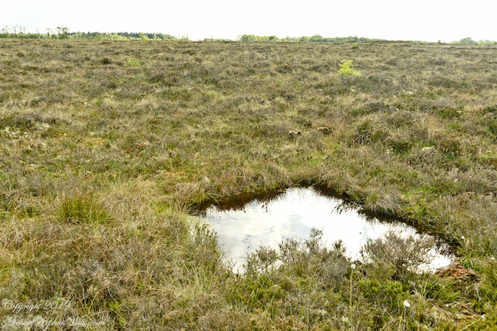
On this occasion we will explore a time machine found four miles south of Kells, County Meath, Ireland.
Step into this pool and you, too, can emerge 4,000-odd years later, skin intact, to achieve fame and fortune, a place in a museum and the record books if such exist 6019 AD. Reference the Cashel Man from Cúl na Móna bog near Cashel in County Laois, Ireland who now resides within the National Museum of Ireland.
Click photograph for the expanded view. To do this from WordPress Reader, you need to first click the title of this post to open a new page.
Girley Bog Pool
True, post mortem fame is hollow for the individual. Maybe, attaching your life story engraved on a gold plaque with a gold chain encircling your torso will offset the loss of your bones (dissolved in the acidic waters) and life itself.
The water of this pool is colored dark by long decayed vegetable matter. Beware of walking the bog surface, it is dangerous and destructive to the environment. Pam and I visited Girley Bog on our tour of County Meath, Ireland.
Copyright 2022 All Rights Reserved Michael Stephen Wills
A roadside shrine on Cottage Road, Inishmore. The faith brought by the saints has deep roots here.
A large crucifix set with wet stone walls with cut flowers. The walls are the native limestone.
It is a spring (early June) afternoon and there are fern and wildflowers. The white flowers are Greater Burnet saxifrage (Scientific Name: Pimpinella major).
The existing dry stone wall was interrupted by the shrine. In the distance are dry stone walls around fields, a stone shed, feeding horses and the sea, being Galway Bay, storm clouds with distant rain.
Aran Islands, County Galway, Ireland.
Roadside Shrine and Island Landscape, Inishmore, Aran Islands, County Galway, Ireland
From the commanding location of Dun Aonghasa, looking northeast across Inishmore island, we can understand why the ancient builders chose this location.
We also see the transition from exposed limestone to the fields built literally from the ground up (see my post “The How of Soil”). For a closer view of island houses see my posts “Settled In” and “Cottage Road Cottage.”