All photography using the IPhone 14 ProMax triple camera, raw format, edited on the phone.
The signage attached to a branch disabused us of this impression, incorrect all for being true until the flowers burst forth.
Magnolia “Golden Gift” Magnoliaceae
Description
A visually beautiful magnolia whose golden flowers bloom in abundance and persist well; a small tree or large shrub with a loosely pyramidal form and large relatively coarse leaves; flowers appear before the foliage; an ideal landscape or garden accent
Ornamental Features
Golden Gift Magnolia is covered in stunning fragrant gold cup-shaped flowers held atop the branches in early spring before the leaves. It has dark green deciduous foliage. The large pointy leaves turn coppery bronze in fall.
Landscape Attributes
Golden Gift Magnolia is a deciduous tree with a distinctive and refined pyramidal form. Its relatively coarse texture can be used to stand it apart from other landscape plants with finer foliage. This is a relatively low maintenance tree and should only be pruned after flowering to avoid removing any of the current season’s flowers. It has no significant negative characteristics.
Ancient
Magnolia is an ancient genus. Appearing before bees evolved, the flowers are theorized to have evolved to encourage pollination by beetles. To avoid damage from pollinating beetles, the carpels of Magnolia flowers are extremely tough. Fossilized specimens of M. acuminata have been found dating to 20 million years ago, and fossils of plants identifiably belonging to the Magnoliaceae date to 95 million years ago. Another aspect of Magnolia considered to represent an ancestral state is that the flower bud is enclosed in a bract rather than in sepals; the perianth parts are undifferentiated and called tepals rather than distinct sepals and petals. Magnolia shares the tepal characteristic with several other flowering plants near the base of the flowering plant lineage such as Amborella and Nymphaea (as well as with many more recently derived plants such as Lilium).
With a neighbor, Sycamore or “Buttonwood”
Copyright 2023 Michael Stephen Wills All Rights Reserved
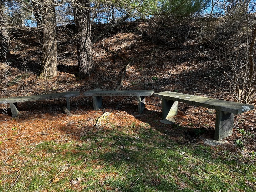
Pam and I ambled around the Arboretum for our Easter 2023 outing. Ezra Cornell had a large farm on the East Hill above Ithaca, New York. As part of locating New York State’s land-grant college in Ithaca, Cornell offered to donate the farm for use as a campus. Parts of this property remain in use as farmland. Our walk followed the outer Arboretum reaches along this research farm.
All photography using the IPhone 14 ProMax triple camera, raw format, edited on the phone.
Growing off the road that loops around the Arboretum, this scraggly pine, the Jack Pine, attracted our attention by the grey colored growths curving around the branches
Serotinous
These are pinecones with the unusual property of not opening, hanging onto the branch, turning this color, until the appropriate conditions arise, serotinous is the botanic term for this. They open when exposed to intense heat, greater than or equal to 50 °C (122 °F). The typical case is in a fire, however cones on the lower branches can open when temperatures reach 27 °C (81 °F) due to the heat being reflected off the ground.
The Color of Younger Jack Pine Cones
Form and Behavior
Tolerant of conditions that preclude other trees, Jack Pines can form pure stands on sandy or rocky soil. It is fire-adapted to stand-replacing fires, with the cones remaining closed for many years, until a forest fire kills the mature trees and opens the cones, reseeding the burnt ground.
Native
Pinus Banksiana, Pinaceae, Jack Pine, Nova scotia to New York and Minnesota
Joseph Banks classified this pine during a 1766 expedition to Labrador and Newfoundland, the scientific name, Pinus Banksiana, is in his honor. Jack Pine is native to eastern North America in the far north, south to northwestern Pennsylvania, including New York State.
Copyright 2023 Michael Stephen Wills All Rights Reserved
My visit to Finger Rock Canyon of the Santa Catalina Mountains filled two mornings. On the first morning, the subject was the lower canyon as morning light filtered over the eastern ridge.
Early morning to the north / northwest looking over a 20-foot fallen Saguaro Cactus (Carnegiea gigantean), toward lower ridges of the Santa Catalina Mountains. The saguaro is among a stand of healthy fellows, some with new growth and flowers on the tips of arms and main columns. This giant must have grown over rock through 60 years. It was brought down when the roots weakened. Specimens that are more reliably rooted can live to 200 years.
A clump of brittlebush shrub (Encelia farinosa) grows from the same rock.
Pima Canyon is the next over, behind that near ridge which provides similar shade. Unlike Finger Rock Canyon, the Pima Canyon trail follows the western cliff and loses the shade much sooner. During our three-week trip, my wife, Pam, and I visited Pima in our first week.
These photos were taken between 6:20 and 7:00 am.
Along the trail I noticed a multitude of buds on the tip of selected saguaro arms. In a previous blog, there’s a photo of this same saguaro in the shade. The following series captures the one blossoming top just as the sun passes over the eastern, shadowing, ridge.
The same saguaro, two minutes later…….
Here is a portion of the saguaro forest, around 7 am with the lower canyon filled with light. There are a few foothill homes with west and southwest Tucson. The Tucson Mountains are in the distance.
These photographs are a continuation of blogs from two days’ exploration of Finger Rock Canyon of the Santa Catalina Mountains, southern Arizona. Here we explore the nature of the Saguaro blossom.
Saguaro flowers start as buds on the tip of the cactus body or arm. The specimen in the photograph below, growing in the yard of a foothills home on the border of federal land, is over 30 feet tall and, at the end of April 2011, buds are sprouting from every tip. Look closely for opening buds and full saguaro blossoms.
Flower buds grow only from some tips and around the center, along the sides, not from the point at the very end of the tip, from which the limb grows.
These buds first appeared mid-April and are here shown in the latter stages of maturity, prior to opening. Sometimes, the base of an arm weakens and the arm lowers close to the ground while remaining healthy. While descending the canyon I noticed this had happened to the arm of a particularly large specimen, an arm in full flower. This and the following photographs are from that arm.
I have read that each flower opens in the cool of the night and lasts only until the following afternoon. Here is a fully blossomed flower with a pair of opening buds.
And more, from a different view of the same arm.
A saguaro flower in full bloom, having opened the previous night. This flower will last a single day. It will wilt in the heat of a single afternoon and close. In this brief time, flying animals will pollinate it. You can see numerous honey bees on the flowers, in a previous blog, “Saguaro Flowers in Finger Rock Canyon.”
The perfection of April in Tucson is nowhere better than mornings spent in Finger Rock Canyon of the Catalina Mountains. Oriented on a north/south axis, the eastern cliffs shed a long shadow well past 9:30 am. For early risers such as me, this means no hat and cool hiking to the canyon head: the trail hugs the eastern cliffs.
These three shots were taken 5:30 – 6:00 am mountain time (Arizona does not follow daylight savings time except on the Navajo Reservation).
About 700 years ago, when the expansion of the Mongol empire was under way, on the other side of the planet people discovered a series of caves, formed in tuff, with a favorable location in a south facing cliff near water. Tuff, a rock formed from volcanic ash, is hard, brittle and soluble in water. From these properties this series of caves formed. The southern exposure provided excellent climate control for people, like those we now call the Salado, who understood how to exploit the location.
They constructed from local materials (mud, plants and rock) rooms in the upper cave just far enough inside to be warmed by the winter sun and protected during the summer when the sun’s sky-path was higher. Who knows how long the Salado lived in what must have been this paradise or why they left.
In March 2006, after returning from a nine-day backpack trip to the remote eastern Superstition Wilderness I used a four-wheel vehicle to reach the Roger’s Trough trailhead for a day trip to this site in Roger’s Canyon. The advantage of Roger’s Trough is the high elevation that leaves “just” about 1,100 feet of climbing (2,200 total) for the day. As it happens, it is downhill to the ruins though there is plenty of ups and downs plus scrambling over rocks.
I started late morning and a returning party met me on the way out and warned against leaving packs unattended. It seems they were victimized by pack rats. My timing was lucky and I had the site to myself.
First (refer to the “Roger Canyon” photograph, above) I climbed the cliff opposite from the ruins to set up a tripod an telephoto lens to shoot through the trees to capture the main building inside that very interesting looking tuff (see below). That central column (to the right) divides the cave opening and there are views from inside, up and across the canyon. In season, the cliffs are occupied by nesting birds and, higher up, there are fascinating caves in locations too high and steep to reach without the proper equipment.
As it is, climbing into the upper cave requires an exposed rock scramble. By “exposed” I mean the climber is exposed to falling. That is an intact wooden lintel of the visible structure opening and the larger structure, to the right, has curved walls.
Salado Cave Ruin
I then explored in and around the site. The location of a lower cave made it useful for storage, it was walled off and the sturdy structure still stands today. By the way, I inverted this view for artistic purposes.
Lower Storage Room
A lower cave is opened and accessible. Looking out, I felt the original inhabitants were with me and then a raven started calling over and over and over.
Lower Cave
I was so fascinated by the possibilities of the site that time got away from me until this incessant cawing of a raven made me notice the lengthening cliff shadows. Here is a view (see below) of my way home, back up Rogers Canyon. My last shot before packing up. It took just over two hours to get out, at a steady pace. It was twilight as I approached the Rogers Trough trail head.
By the way, my posting before this one (“Finding Circlestone”) includes a shot of White Mountain. In that view, these ruins are on the other side of White Mountain.
View up Rogers Canyon from the Ruins
Copyright 2023 Michael Stephen Wills All Rights Reserved
I first learned about Circlestone from stories The Searcher told during my first backpack into the eastern Superstition Mountains, on the Tule trail, April 2005. I described this in “Riding from Pine Creek to the Reavis Valley” where the Searcher described a stone circle, overgrown with Alligator Juniper, on the slopes of Mound Mountain. He pointed south toward a peak and foothills that rose from the valley floor and said, “follow the fire trail east from the southern Reavis Ranch valley.” There were strange happenings associated with Circlestone (as he called it) and he’d never taken the time to go there. “There is a book full of stories.” I eventually sought out Circlestone on the web and in books, but after I found it on my own using only the Searcher’s directions and advice from friends met on the way.
Sunset from Castle Dome
Backpacking with my sister
In 2006 I explored Circlestone twice along with my sister, Diane, who accompanied me. First for nine days early March 2006 using the Reavis Ranch trail from the north and the second for five days in November 2006, coming us the same trail from the south. Our first trip was Diane’s first “real” backpack adventure and we took it slow with a camp at Castle Dome where there are flat areas and exceptional views. Above, is the sunset from our second night (I camped the first night next to the car…we took it very, very sloooowwww).
Four Peaks Sunrise
Castle Dome
Then, there was morning of our third day. Here is the Four Peaks Wilderness in the first rays of dawn. These are green, rolling foothills of grass, low shrubs and a few juniper. If you know where to look, there’s an unmarked trail to Reavis Falls (the highest waterfall in Arizona). I found the trail and visited the falls on a later trip.
Castle Dome Sunrise
After enjoying the Four Peaks, you turn around and see Castle Dome in the morning light, as in this photograph. Remember the same of the “dome”, because it is visible from the ultimate view from Circlestone.
Reavis Valley and White Mountain from the trail to Circlestone
The Trail to Circlestone
Our camp was in the Reavis Valley, one of the first sites along the creek coming from the north. There were fantastic rock formations across the creek. Not far from there, the land falls away into steepness and then Reavis Falls. The Searcher told me about going that way, once. There is no trail down to the falls overlook and deep canyon carved by the water.
This photograph, above, is from a lovely forest of pinyon trees that grow along the trail to Circlestone (described by the Searcher as rising from the southern Reavis Valley). You can see the valley, just to the right, and a longer and steeper valley that rises from it up to White Mountain. That way is the southern legs of Reavis Trail. I have a movie clip from this same spot of the pinyons moving in the breeze and may post it at a later time.
All of the trail to Circlestone is a climb. You pass over “Whiskey Spring”, named for a still kept there in the 1800’s and over a steep defile gouged from the rock. The trail is well marked and I am told that, sometimes, there is no cairn marking the trail to Circlestone. If you are desperate to get there, look-up some excellent hiking directions available on the web. I have even found the circle on GoogleEarth, since I know where to look. If you like a challenge and the adventure, go from the directions the Searcher gave me.
Four Peaks from Circlestone
From the fire line trail, the unmarked branch to Circlestone climbs steeply and follows a ridge through Alligator juniper, punctuated by stalks of century plant, to a broad way that rises to Circlestone as though to a monument overgrown by the same juniper.
My Circlestone Mystery
There was an unusual experience on our first trip, on this portion of the trail. We were winding through the Juniper and, as it happened, Diane fell behind. After awhile I missed her and waited and, after a minute, went back to look for her. I found Diane sobbing uncontrollably, deep in grief over our father who passed away eleven years before. We talked about it until she felt better. She said it was as though a door opened and she could feel out father. What makes this exceptional is Diane is not given to anything like this and I ascribe her deep grief to the nature of the site. It is a mystery to this day.
At Circlestone, that first trip, we explored and experienced the site. You cannot see the entire wall at any point and need to wander through and over it, being careful not to disturb anything. Here and there, in the outer wall, are openings like the one in this photograph.
Site-Hole in the Circlestone Wall
At Circlestone
I call it a site hole because, on your knees, it is possible to look through and see the distant view through the trees. As you can see, the stones are a striking red color with green lichen growing thick.
On the second trip in November, knowing the way and having great weather, I brought my cameras to capture the exceptional views, one of which is above. I’d dearly love to come back to camp just below the ruin and do some work in the evening and morning light. For now, I can enjoy those views from Castle Dome.
Three Horsemen and Castle Dome
Can you see the dome in the middle distance. I did a portrait of three horsemen who road up to Circlestone in November. We came to know them pretty well, that afternoon and the following morning down in the valley.
Three Horsemen
I carted up a tripod, so you can see Diane and I in the same spot.
Mike and Diane at Circlestone
Copyright 2023 Michael Stephen Wills, All Rights Reserved
In town for a University of Arizona event I gazed from the Marriott before dawn to remember painting “A” mountain with the Sophos service club a half century ago. The tradition continues.
The view to the southwest includes University Neighborhood, downtown Tucson skyscrapers, “A” Mountain (painted red, white and blue November 2010), Tucson Mountains.
Stenciled on asphalt pavement along the Cayuga Lake Inlet, the white paint delimits dandelion flower stalk and seedhead, mostly denuded, with floating seeds held aloft by the pappus.
A circular bench that has seen better days, a hollowed out tree trunk repurposed as a children’s playgound house, picnic benches and, in background, a portion of the Farmer’s Market pavilion, to the right is Johnson Boatyard, Cayuga Inlet and lake. This is the Steamboat Landing, historically the southern port on Cayuga Lake. The entire area is long overdue for a facelift.
Painted on the side of restroom building, various shades of blue, black outlines, something or other holding a trident surrounded by fanciful fish.
On the trail to Lighthouse Point, this tree is in fine winter form on this early spring afternoon in March. Newman Municipal Golf Course
Cayuga Lake Views from Lighthouse Point
Copyright 2023 Michael Stephen Wills All Rights Reserved