A span of 10,000 years spreads between now and the first possibility of settlement on the island of Eire, then swept clean to bare rock by the weight of ice. Current scholarship of the Dún Aonghasa ruins, Inishmore, County Galway, the Irish Republic place a settlement within the inner of the four dry stone rings after 6,500 years (1,500 BC or 3,500 years ago). By way of scale, the first settlement took about 30 times the duration of the U.S. Constitution ratification through 2025: the last state, Rhode Island, ratified the Constitution 1789.
By 700 BC, 2,700 years ago, a series of upright, closely placed stones, were erected between the second and third rings called a cheval de fries field (“Frisian horses” in English) today, this defensive structure evokes the enormous scale of the struggles around this place of defense.
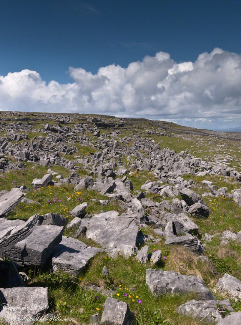
This is a portion of that field, I believe, taken as Pam and I approach the inner ring entrance, walking a wide path cleared of barriers. Click the photograph for a larger image with caption.
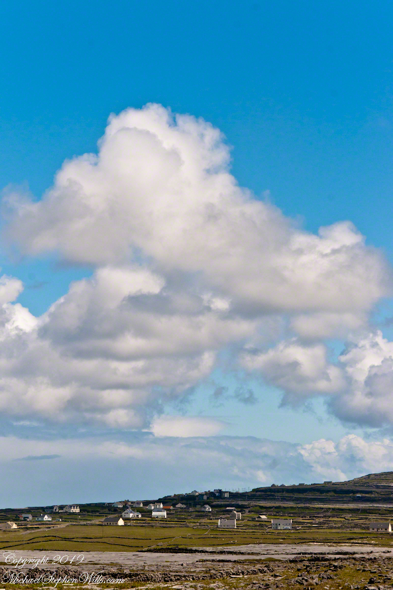
From the commanding location of Dún Aonghasa, looking northeast across Inishmore, the logic of the ancients becomes clear. No better vantage could be found—land unfurling like a hand toward Galway Bay, cottages nestled in green folds, clouds billowing above like sails caught mid-journey. A place of presence. A place of permanence.
Perched high on the cliff’s edge, the fort behind, the Atlantic at the back, the wind carried stories—unwritten, unspoken, but felt in the bones. Below, stone walls divided the island into patterns of memory. Fields outlined in rock, laid long ago by hands familiar with hardship and patience. The sea’s pulse echoed faintly in the distance, as steady and unfathomable as time itself.
No words were needed in that moment. Just the hush of sky and stone. Cottages, bleached bright by limewash—kalsomine, the old name still whispered by some—stood resilient against the elements, each one a witness to generations. Each one seemed to carry a personal reverence, a tenderness carved into the landscape.
Paths led gently inland, where wind slowed and voices from distant homes rose faintly through the open air. Along those paths, the rhythm of island life could be read in hoof prints, scattered wool, and the sharp, clean edges of hand-cut stone. There, among the hedges of limestone and wild grass, the living and the lost felt close.
The cloud cover shifted constantly. Shadows passed like thoughts across the land. Toward the shore, the sky opened wide. A silence filled the lungs, as bracing and deep as the Atlantic itself. Time seemed to slow, the mind slipping into the rhythm of the land.
Limestone pavement, rough beneath the boots, told its own tale of erosion and survival. That the earth here could sustain even the most modest farming seemed improbable. Yet here it was: a testament to stubborn hope and quiet ingenuity. In that quiet, ancient energy rose—something older than the fort, older than language. A pulse shared with the rock and wind.
The fort eventually came back into view—perched as if grown from the cliff itself, curved walls enclosing nothing but air and sky. I perceived no defensive bluster, only presence. And what a view it commanded. On days like this, the clouds formed towering cathedrals overhead, white and gold in the sun. Below, the cottages and fields seemed miniature, perfect, enduring.
The wind played echoes of prayer, lullaby, and laughter mingled with the call of seabirds. The thought came that nothing here was ever truly lost—only layered. Generation upon generation, each leaving some trace: a stone placed just so, a wall mended one final time, a cottage roof patched for another winter.
Here, even the air speaks. It moves gently but insistently, brushing the cheeks and stirring something ancient within the chest. Beneath it, the island breathes: not loudly, not urgently, but with the slow, deep rhythm of the tides.
As the sun dipped slightly westward, light changed across the fields, cottages glowing warm against darkening green. The wind softened. The clouds drifted, still massive but no longer looming. Time to return. A glance back offered one last communion with sky, stone, and silence.
Inishmore, on that day had been absorbed. Understood not with the mind, but with something quieter. Something that listens without need for words.
It was the kind of overcast morning that seems to cradle the island in a blanket of mist, a gentle hush falling over the land as though even the Atlantic held its breath. Pam and I had arrived by ferry at Kilronan, the main settlement on Inishmore (Inis Mór), the largest of the Aran Islands nestled in Galway Bay. There, amid the bustle of arrivals and greetings, we found our driver—a wiry, weather-worn man with a soft brogue and kind eyes—and his horse trap, a simple two-wheeled carriage with room enough for three and the sounds of hooves to accompany our journey.
We set out up Cottage Road, the stone-paved track winding westward from the harbor. The sea fell away behind us as we climbed, a gray shimmer stretching to the hazy outline of Connemara’s mountains on the far side of the bay. Our destination was the dramatic cliffside ringfort of Dún Aonghasa, a place older than memory. But it was the unexpected moments in between—the ones not printed in guidebooks—that linger longest in the mind.
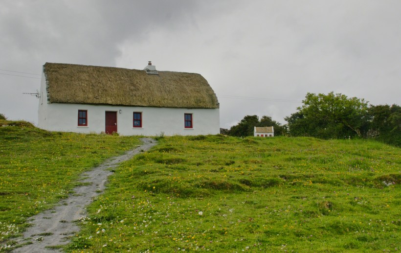
As we rounded a bend flanked by low stone walls, wildflowers blooming defiantly in the cracks, our driver pulled the reins gently and pointed with his crop.
“There,” he said, nodding ahead, “is a fine example of a traditional Aran cottage.”
And there it was—a vision from another time. The thatched roof curved softly like a that blanket itself, straw golden against the brooding sky. The walls were whitewashed to a perfect matte sheen, gleaming in spite of the cloud cover. A crimson door and two window frames punctuated the front façade like punctuation in a poem. Just to its right, set further back on the hill, stood a tiny replica of the same cottage, identical in every feature. I blinked, half believing it was an illusion.
This thatched cottage with matching child’s playhouse is on Cottage Road out of Kilronan Village on the Aran island, Inishmore, County Galway, Ireland.
We only stopped briefly—it was a private residence—but the sight of it left a kind of imprint. I turned in the trap seat to keep it in view as long as I could. The cottage was perfectly placed, facing Galway Bay with a commanding view. I imagined the light pouring across the line of mountains, catching the glint of sea and sky.
“There’s a name for that finish,” I said, recalling something I’d read, “whitewash, or lime paint.”
Our driver nodded. “That’s the old way. Made from slaked lime. We’d call it ‘whitening’ when I was a lad.”
Whitewash differs from paint in the most elemental of ways. It becomes part of the stone, absorbed into the very surface. Like a memory of bone. And yet, it requires care. Apply it to a wall not properly cleaned or moistened, and it flakes, pulls away like a broken promise. But done right, it lasts, breathes with the building.
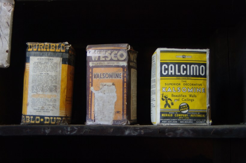
Upon our return, researching “whitewash,” if found this photograph from the Yarloop railway workshops Yarloop, Western Australia. There, on a shelf, where three old boxes sat like relics: DURABLO, WESCO, and CALCIMO. All contained kalsomine—the powdered form of lime paint. CALCIMO promised to “beautify walls and ceilings” and was proudly marked “LIME PROOF.” There was something quietly heroic in that. Lime-proof, as though against time itself.
Looking at the box of Calcimo, a product of the Murabo Company of Australia, I was struck by how far the tradition had traveled. From island cottages in the Atlantic to distant corners of the Southern Hemisphere, the language of whitewash—of simplicity and purity—had touched the world.
We returned by the same road, past that same cottage, the small one still keeping watch beside it like a child beside a parent. And I knew then that the islands hadn’t just given me sights—they had offered stories, silent ones written in thatch and stone, in lime and wind.
Sources for this post: search wikipedia for “White Wash”. White wash photo author: Wikipedia commons user Gnangarra
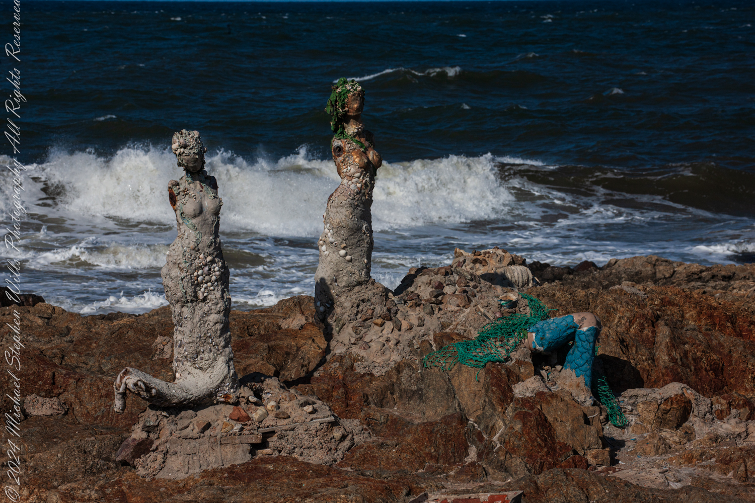
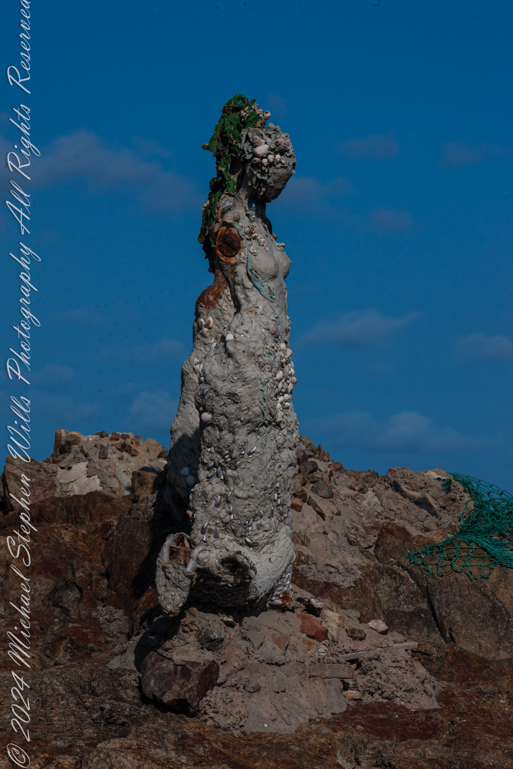
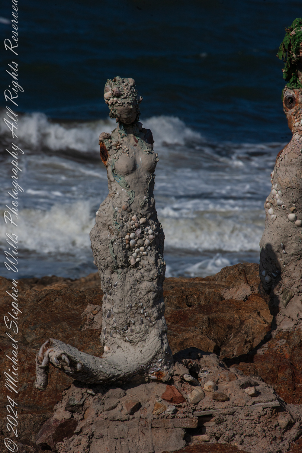
The wind carried the scent of the sea as we stood at Punta de las Salinas, the furthest tip of Punta del Este, Uruguay. This was a place of myth and mystery for us, where the Atlantic Ocean merged with the Río de la Plata, and where the rocks bore witness to the timeless interplay of water and stone. Here stood “El Canto de las Sirenas” (The Song of the Mermaids), an evocative art installation by Lily Perkins, first completed in 2012. The sculptures seemed perfectly at home here, their placement deeply intertwined with the mythology they evoked.
This is at Great Britain Square, Punta de las Salinas of Punta del Este. We are at the tip of the peninsula, the easternmost point of Uruguay. This is the art installation El Canto de las Sirenas” (The Song of the Mermaids) (2012) by the artist Lily Perkins. Punta del Este, Departamento de Maldonado, Uruguay
The sirens of ancient lore were said to dwell at perilous points where land met the untamed sea, luring sailors to their doom with haunting songs. These rocky outcrops, both a boundary and a threshold, have long held symbolic power as places where the natural world is at its most raw and elemental. Punta de las Salinas is such a place. Its jagged rocks and churning waves create an environment as beautiful as it is treacherous. It is easy to imagine mythical sirens choosing this very spot to weave their spellbinding melodies.
This is at Great Britain Square, Punta de las Salinas of Punta del Este. We are at the tip of the peninsula, the easternmost point of Uruguay. This is the art installation El Canto de las Sirenas” (The Song of the Mermaids) (2012) by the artist Lily Perkins. Punta del Este, Departamento de Maldonado, Uruguay
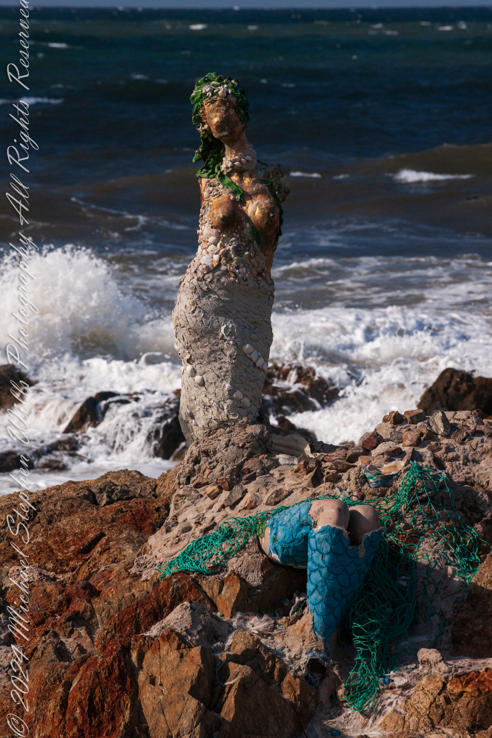
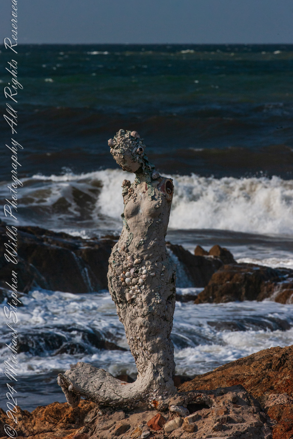
Lily Perkins’ installation captures this essence. The sculptures are not idealized depictions of mermaids; they are rugged and raw, encrusted with shells, stones, and marine debris. Their weathered forms mirror the harsh, untamed beauty of their surroundings. It is as if they have emerged from the ocean itself, born of the waves and the salt-laden air, to stand as sentinels at the edge of the world.
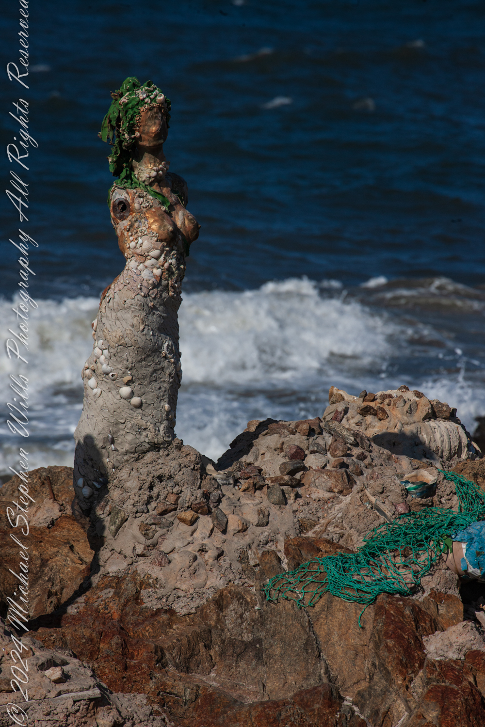
The central figure, with her face turned skyward, evokes the myth of the siren’s song—a melody so enchanting that it drove sailors to risk their lives against the rocks. Her posture suggests longing, perhaps for a connection beyond the horizon, or perhaps for the very mortals she is fated to ensnare. Nearby, a broken figure reclines against the rocks, her form partially encased in green netting and mosaic-like tiles. She seems more grounded, her siren’s call muted, as if weighed down by the realities of the modern world. The use of marine materials in her construction—a blend of natural and human-made debris—suggests an awareness of humanity’s impact on the seas.
The third figure, slightly apart, is the most enigmatic. Encrusted with barnacles and weathered by the elements, she seems lost in thought. Her gaze is directed not toward the sea but toward the land, as if contemplating her place at this meeting of worlds. In mythology, sirens were liminal creatures, existing between realms—the sea and the shore, the mortal and the divine. This figure embodies that in-between state, rooted in the rocks yet shaped by the sea.
The placement of these sculptures at Punta de las Salinas is no accident. This headland is the easternmost point of Uruguay, a natural boundary and a crossroads where two vast bodies of water meet. For centuries, sailors navigated these waters, their journeys fraught with danger. The rocks here are unforgiving, and the waves crash with relentless power. To stand at this point is to feel the raw energy of the ocean and to understand why myths of sirens arose in such places. The sirens symbolize both allure and peril, a reminder of the ocean’s capacity to inspire and to destroy.
As I walked among the sculptures, the mythology seemed to come alive. The sound of the waves crashing against the rocks could easily be imagined as the sirens’ song—a hypnotic rhythm that draws you in and holds you spellbound. The figures, though silent, seemed to hum with an energy that echoed the sea’s eternal motion.
I feld these sculptures were not merely placed at Punta de las Salinas; but had emerged from it, their forms shaped by the same forces that shaped the rocks beneath our feet. The shells and stones embedded in their surfaces tied them physically to the sea, while their mythical resonance tied them spiritually to the place.
The mythology of the sirens speaks to the duality of the sea—its beauty and its danger, its capacity to give and to take away. Standing at Punta de las Salinas, surrounded by Perkins’ sculptures, I felt that duality in a profound way. The ocean stretched endlessly before us, a vast, unknowable expanse, while behind us lay the solid ground of the peninsula—a place of safety, but also a place that ended here, at this edge.
Lily Perkins sculptures are restored…..
As we left, the figures seemed to watch us go, their silent song lingering in my mind. The sirens of Punta del Este are more than art; they are a dialogue between myth and reality, between the natural world and the human imagination. In their weathered beauty, they remind us of the stories the sea has always told, and of the enduring power of those who give those stories form.
Enter your email to receive notification of future postings. I will not sell or share your email address.
Copyright 2025 All Rights Reserved Michael Stephen Wills
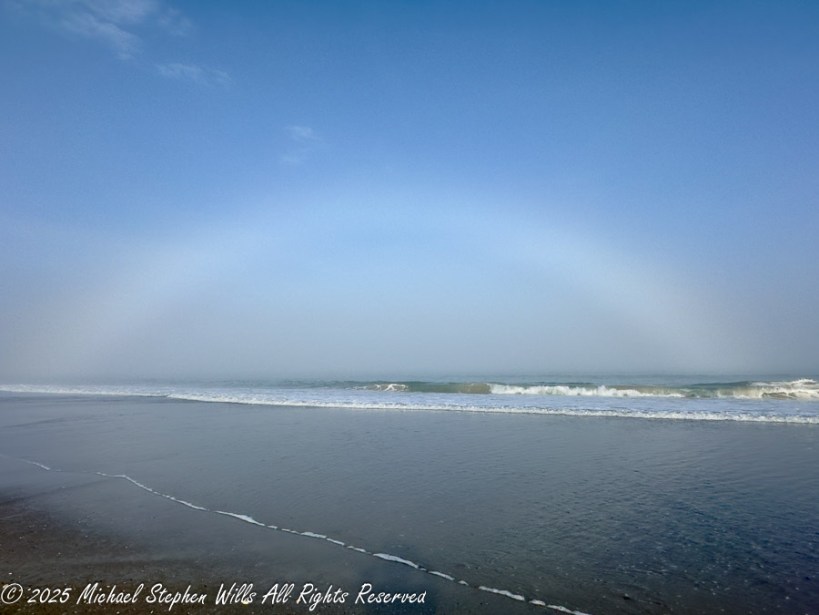
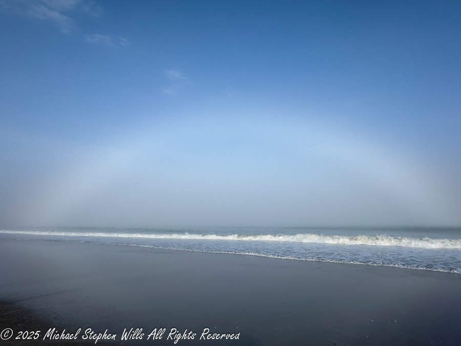
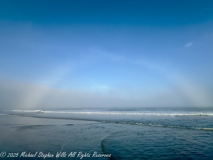
I had a haunting experience at Cocoa Beach, witnessing a rare fogbow—a ghostly arc formed by fine mist—evoking emotions and reflections on nature’s beauty.
The fog haunted Cocoa Beach for days, softening the edges of the afternoon. I had been walking along Cocoa Beach, feeling the cool ocean breeze on my face, when I noticed a change in the light. It was a little after four, the sun drifting lower in the western sky, its warmth fading into a hazy glow. The air smelled of salt and mist, and waves lapped gently at the shore, their rhythm unbroken by the deepening fog.
And then I saw it.
A pale arc stretched across the horizon, a ghost of a rainbow bending above the waves. At first, I wondered if my eyes were playing tricks on me—where were the usual bright bands of red, orange, and violet? But no, the arc was real, a fogbow, forming where sunlight met the fine sea mist. Unlike the rainbows that appear after summer storms, this one was almost entirely white, as if the ocean had conjured it from air and silence.
Sailors once whispered of such things—a white rainbow at sea, a sign of hidden land or wandering souls. Some believed it to be a bridge between realms, a fleeting passage where the living and the lost might momentarily brush against one another. Others saw it as an omen, a spectral warning of treacherous fog ahead. I wondered what the mariners of old might have thought, standing at the bow of a ship, watching a pale arc rise from the mist, its edges dissolving like breath against glass.
I stood still, watching, as the science of the moment unfolded before me. Unlike traditional rainbows, which form when light bends through large raindrops, fogbows are born from infinitesimally smaller droplets, often less than 0.1 millimeters in diameter. Their size diffuses the light, scattering it so finely that the colors blend together into a spectral whisper rather than a vibrant shout. The physics of it fascinated me—this was diffraction in action, nature bending light in a way that rendered it nearly colorless.
The effect was surreal. The fogbow arched over the breaking waves like something out of a dream, a halo of sea and sky, momentary yet timeless. It seemed to pulse in the shifting mist, visible one moment, fading the next, as if deciding whether to reveal itself fully or slip back into the fog’s embrace.
For several minutes, I just stood there, taking it in. The world felt different inside that mist, quieter, more reflective. The fog dampened the usual sounds of the beach—the calls of shorebirds, the laughter of distant walkers—leaving only the hush of the waves and the distant hum of the ocean’s breath.
I knew that fogbows were rare, requiring just the right balance of thin fog, moisture, and a low-angled sun. I was lucky to be in the right place at the right time, a witness to something subtle yet profound.
And just as silently as it had appeared, the fogbow began to dissolve. The mist thickened, swallowing its arc, the sky shifting back to its usual muted gray. But the memory of it lingered—a white rainbow over the sea, ephemeral and elusive, like a secret the ocean had briefly chosen to share.
Enter your email to receive notification of future postings. I will not sell or share your email address.
Copyright 2024 All Rights Reserved Michael Stephen Wills
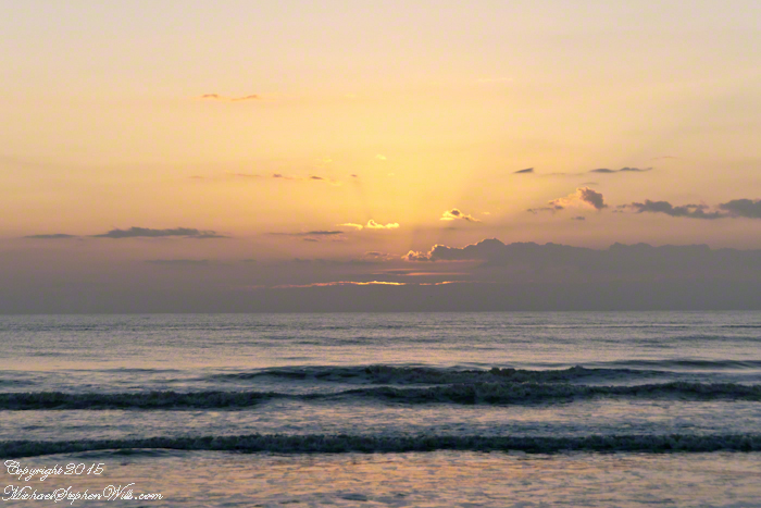
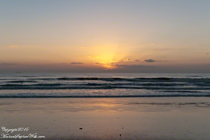
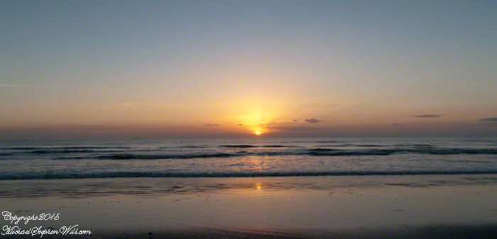
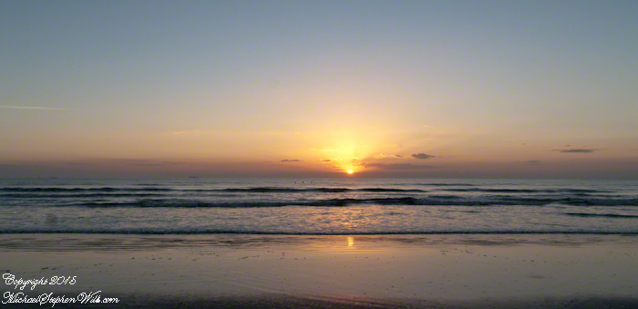
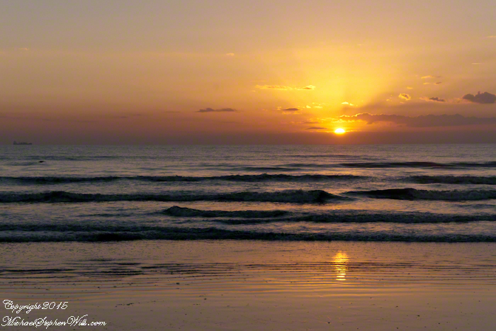
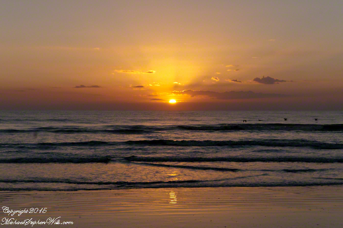
Experience the breathtaking sunrise at Cocoa Beach, where the sky and sea blend in a symphony of colors. Discover the tranquility and beauty that awaits as the day dawns on Florida’s stunning Space Coast.
Cocoa Beach, nestled in Brevard County, Florida, is renowned for its pristine sandy shores and the rhythmic lullaby of the Atlantic Ocean. It’s a place where the day often begins with an awe-inspiring sunrise. On the Space Coast, the first light of day is a daily masterpiece, a silent symphony of colors that paints the sky and reflects off the water.
As dawn approaches, the eastern horizon begins to glow with a soft, pre-dawn light. This quiet time, when the world is still asleep, offers a unique tranquility. The beach, usually bustling with surfers, sunbathers, and families, is calm and serene. The sand, cool underfoot, stretches out like a vast canvas, waiting for the sun to begin its artwork.
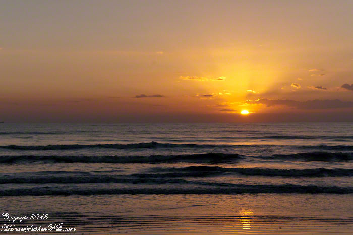
The first hues of sunrise start as a gentle blush, a hint of pink that softly caresses the sky. As the moments pass, this blush deepens into shades of orange and red, reminiscent of a painter’s palette. The ocean mirrors these colors, creating a breathtaking scene where sky and sea blend into one continuous expanse. It’s a moment that feels almost sacred, as if nature itself is preparing for a grand reveal.
The sun finally peeks above the horizon, a fiery orb that illuminates the world in golden light. This is the crescendo of the sunrise, a moment that seems to hold the breath of the world. The rays of light stretch out across the water, casting a shimmering path that invites the eyes to follow. It’s a path that feels both real and ethereal, leading not just across the sea, but into a day full of possibilities.
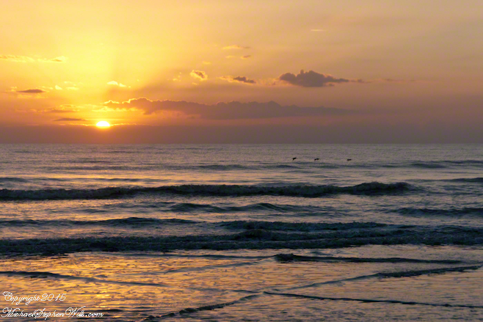
As the sun rises higher, the colors in the sky shift and change. The deep reds and oranges give way to softer yellows and then to the clear, bright light of morning. The ocean, too, transforms, taking on a deeper blue as the sunlight penetrates its depths. The waves, which had been gentle ripples in the pre-dawn light, now dance and sparkle, as if celebrating the arrival of the new day.
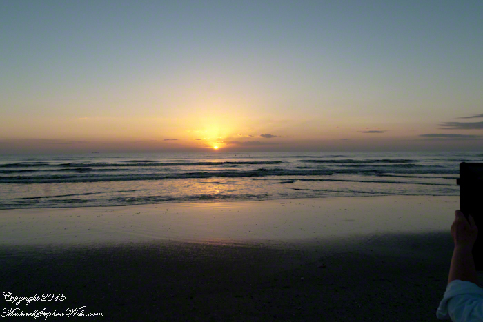
For those fortunate enough to witness it, a sunrise at Cocoa Beach engages all the senses. The cool breeze carries the fresh scent of saltwater, a reminder of the ocean’s vastness and power. The sound of the waves, steady and rhythmic, provides a soothing background score, while the occasional cry of a seabird adds a touch of the wild to the scene.
Click on a photo for a closer look.
There is a sense of community among the early risers who gather to watch the sunrise. Strangers often share nods and smiles, united by the shared experience of witnessing something so beautiful and ephemeral. It’s a reminder that, no matter our differences, moments of natural beauty can bring people together, fostering a sense of connection and shared humanity.
Cocoa Beach, known for its proximity to the Kennedy Space Center and its surf culture, offers much more than meets the eye. The sunrise is a daily reminder of the simple yet profound beauty of nature, a beauty that exists beyond the man-made attractions and the hustle and bustle of everyday life. It’s a call to pause, reflect, and appreciate the world around us.
In a place where rockets soar into the sky, touching the very edge of space, the sunrise at Cocoa Beach brings us back to Earth, grounding us in the timeless rhythm of the natural world. It’s a moment of peace and renewal, a gift from the universe to start the day with a heart full of wonder and gratitude.
So, whether you’re a local or a visitor, taking the time to watch the sunrise at Cocoa Beach is an experience not to be missed. It’s a chance to witness the world waking up, to feel a part of something larger than oneself, and to start the day with a renewed sense of awe and possibility.
Copyright 2024 Michael Stephen Wills All Rights Reserved
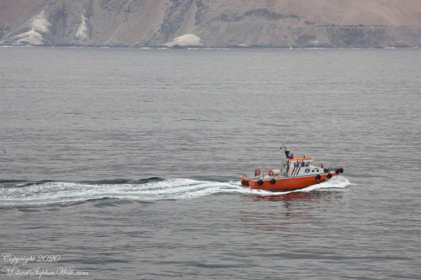
Discover the vibrant blend of history and modern maritime traditions in Iquique. From the dramatic escarpment backdrop to the bustling harbor, join us on a journey exploring the city’s past and present, anchored in seafaring tales.
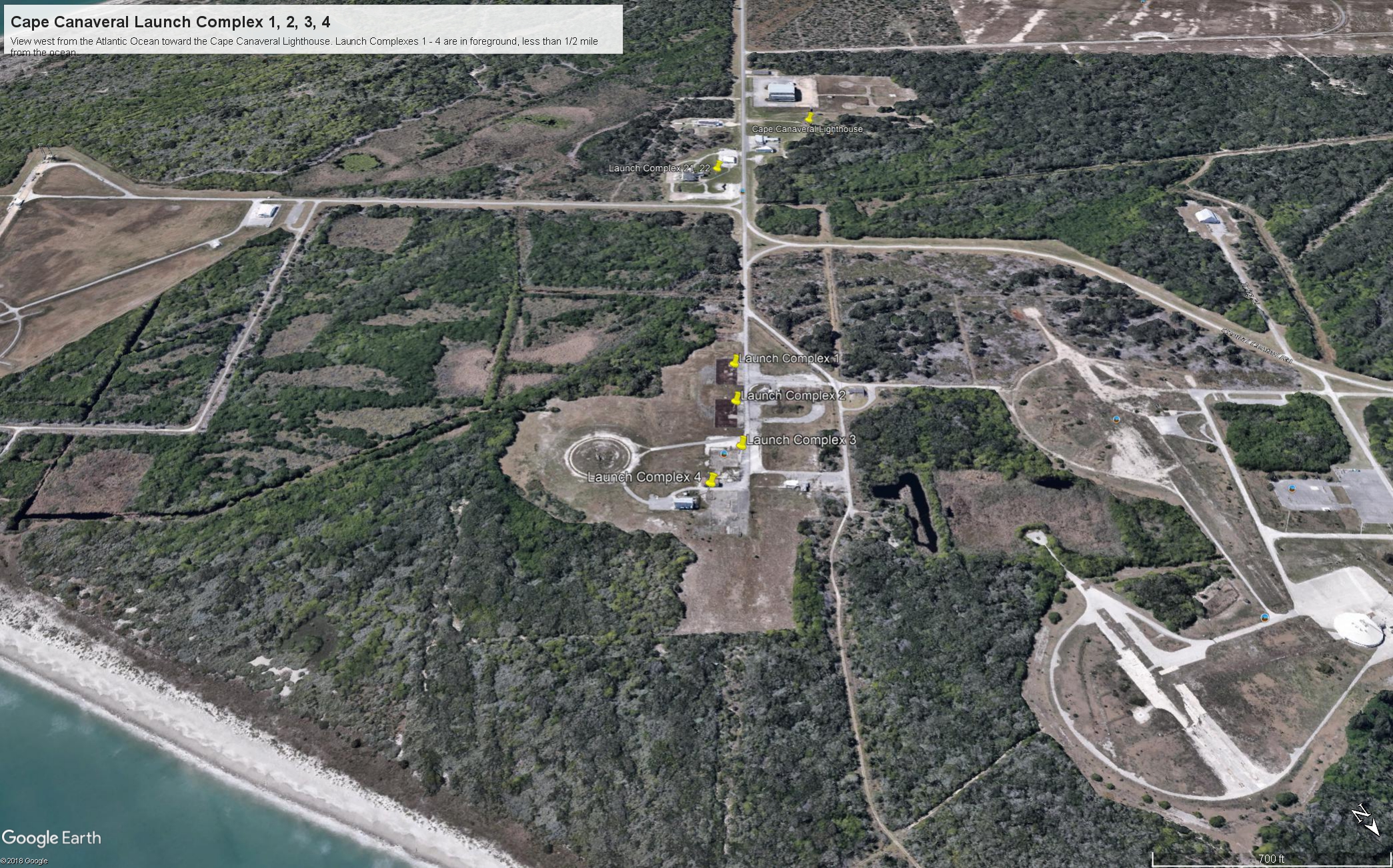
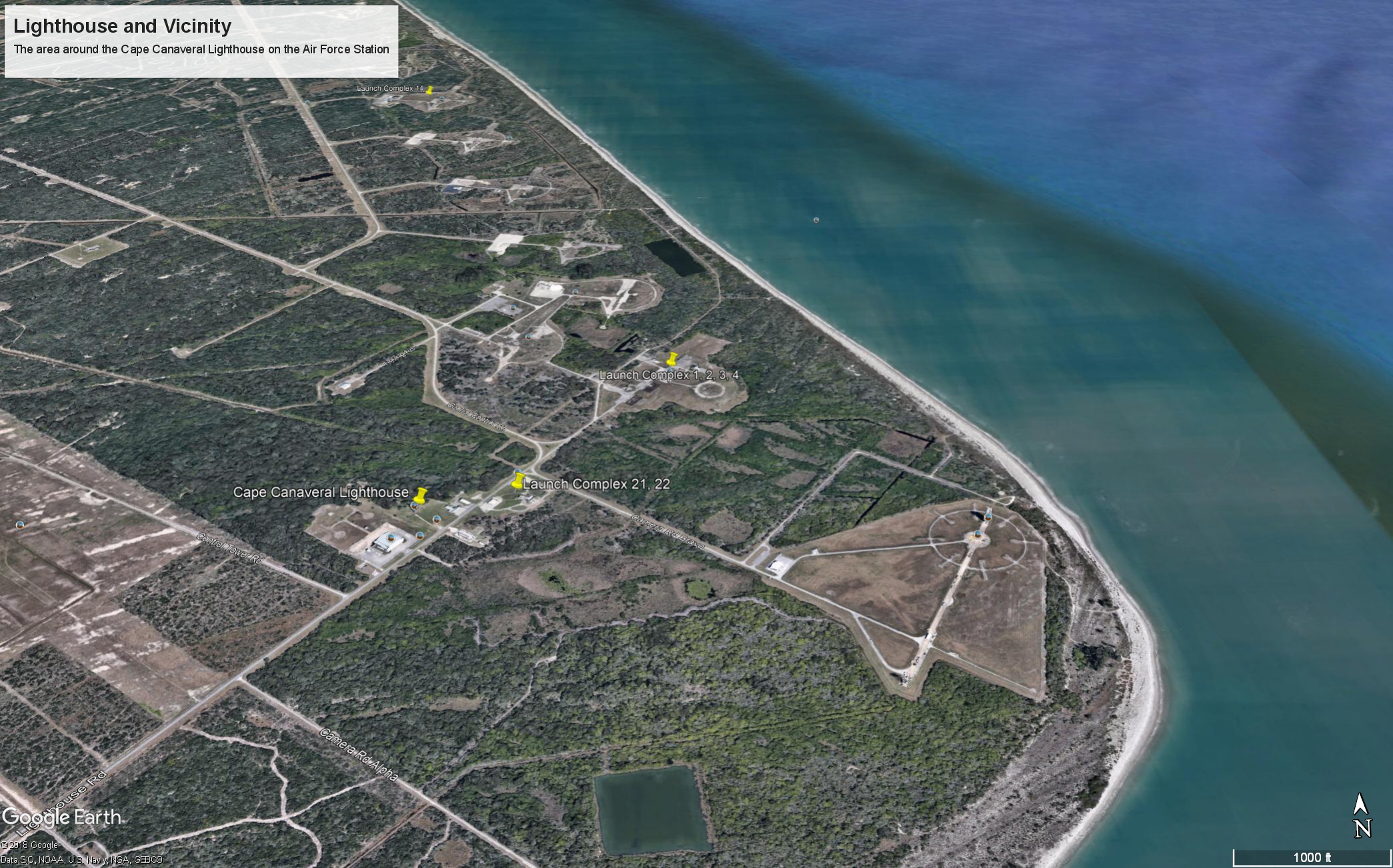
Here is the fifth in a series of photographs centered on the early history of space flight on Cape Canaveral mostly taken during a tour organized by the Cape Canaveral Lighthouse Foundation. “Google” the foundation for details of future tours. Here we explore the sites of the first launches on the Cape, Launch Complexes 1, 2, 3, 4. (LC 1 – 4).
From Vengeance To Space
Our bus proceeded east on Lighthouse Road past Launch Complexes 21 and 22 in less than half a mile we were within the first sites of the United States Space age, sites with the lowest numbers, LC 1 – 4.
Click Any Image for a larger viewe
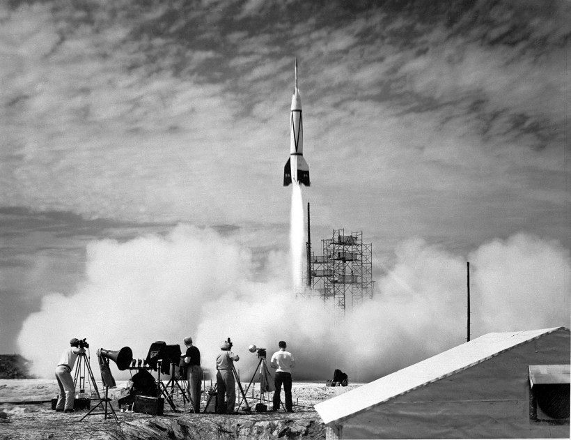
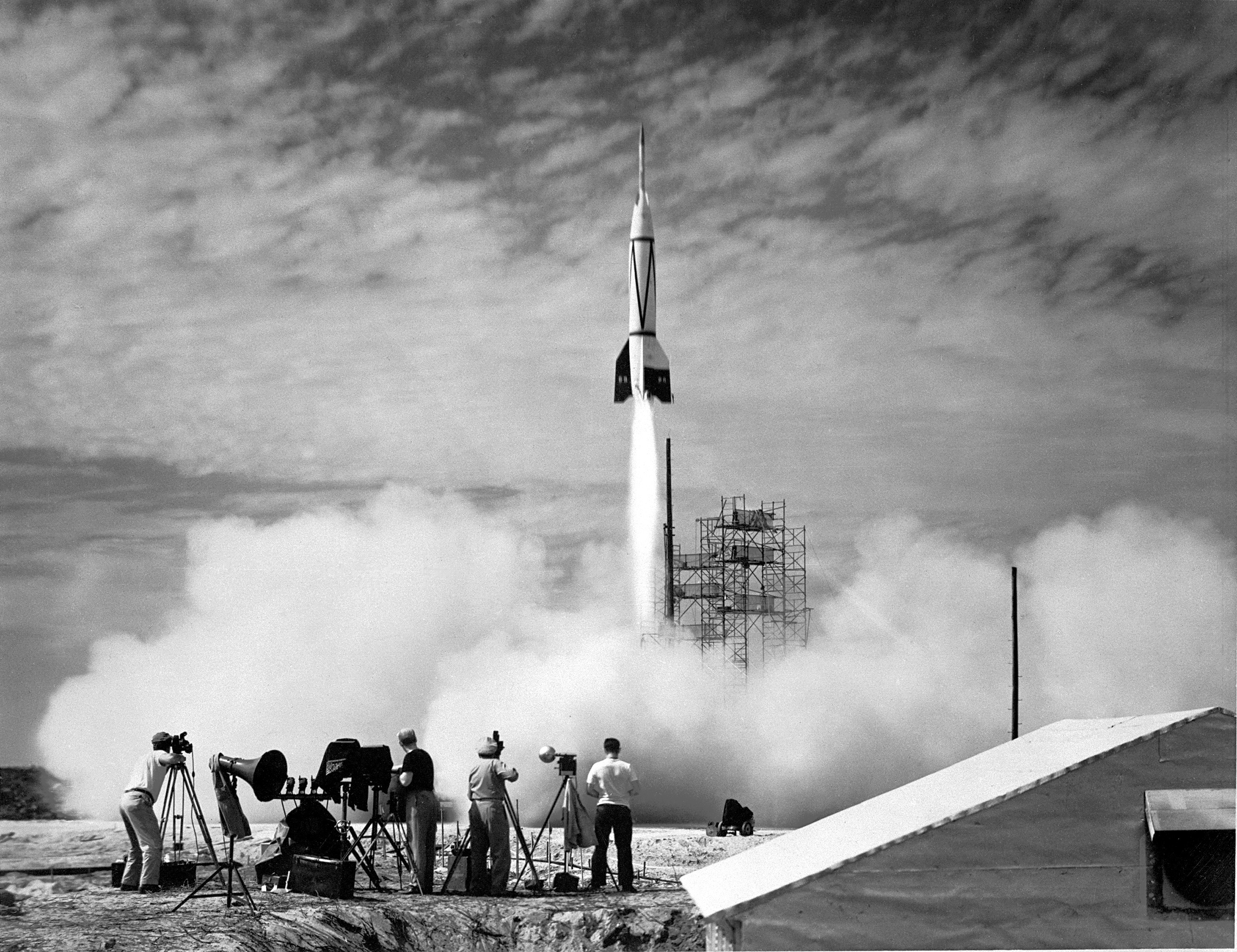
If, instead of distance, the bus traveled back in time 68 years to July, 1950 we would be witness to the first United States space launch of the two-stage “Bumper 8”, a former “V2” missile topped by a WAC Corporal that reached 248 miles above the earth, about where the International Space Station circles now.
The Nazi “vengeance weapon 2”, the V2, a device so horrifying British authorities claimed the first V2 attacks to be “gas explosions” rather than admit a Nazi weapon descended without warning. Beginning September, 1944, over 3,000 V2’s landed on London, Antwerp and Liège resulting in an estimated 9,000 deaths, mostly civilians. 12,000 forced labor and concentration camp slaves died in the construction of the production facilities captured by the Soviet Union during the collapse of the Nazis. These victims, arms linked, will form a circle 15.9 miles in circumference around the Bumper 2 launch.
The 21,000 V2 victims, linked arm in arm, make a circle 15.9 miles in circumference.
von Braun and key V2 personnel surrendered to the Americans and, along with enough parts to construct 80 V2s, were taken to the United States. His direction of US missile development lead eventually to the enormous Saturn rocket that lifted three men to the moon, so good came from our bet on vonBraun and the V2.
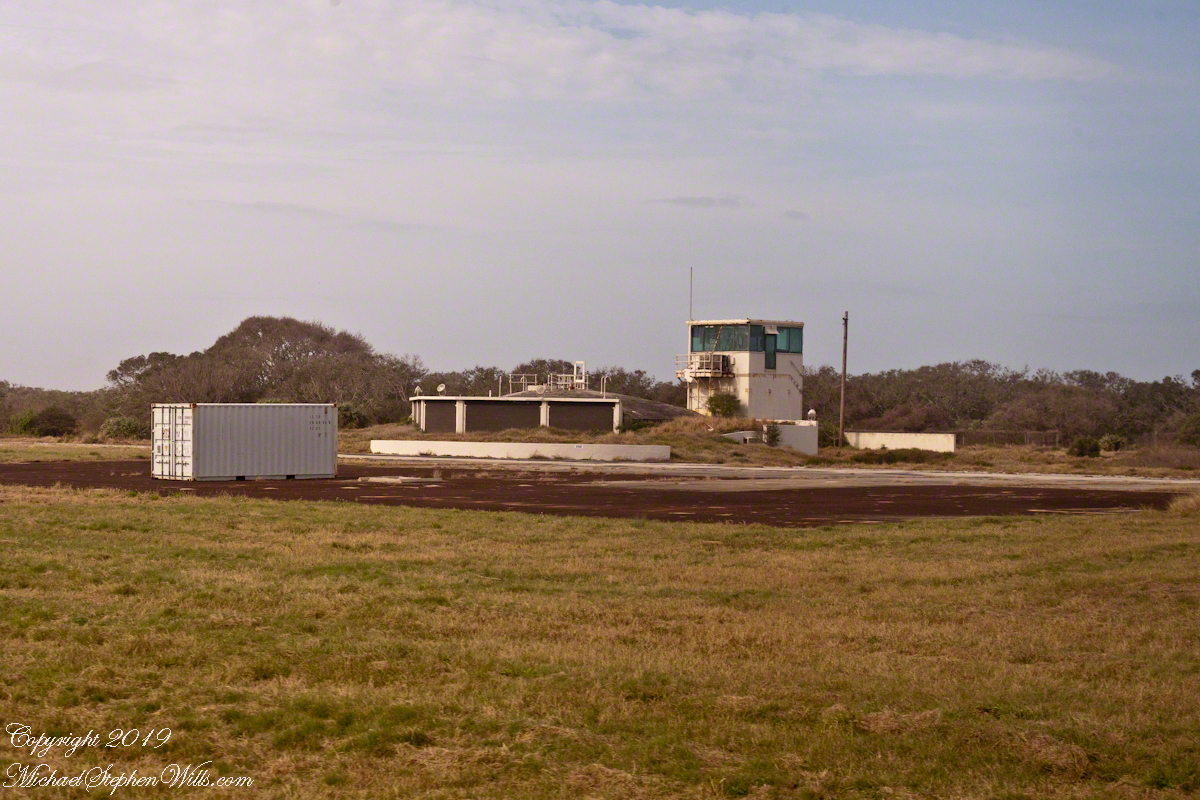
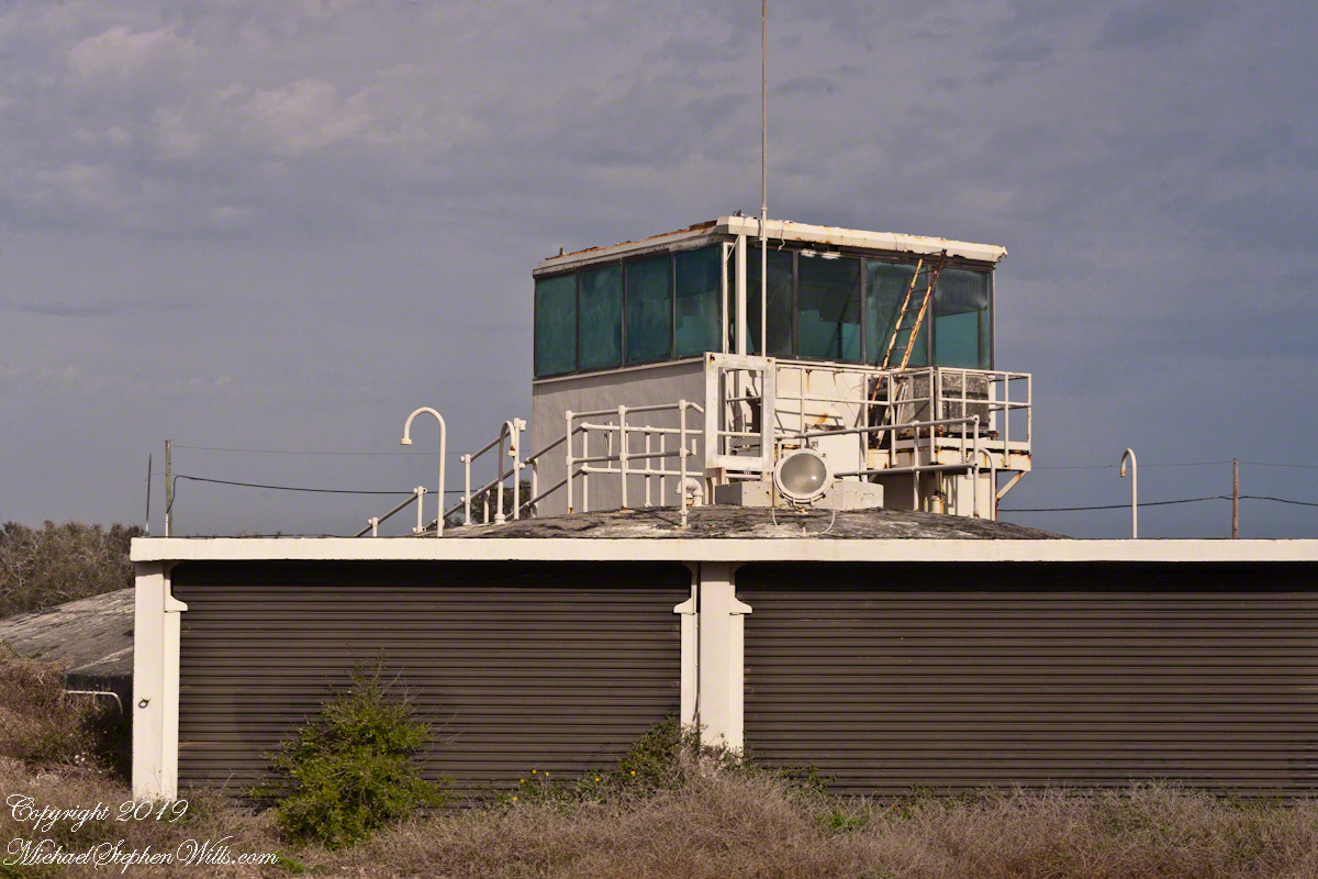
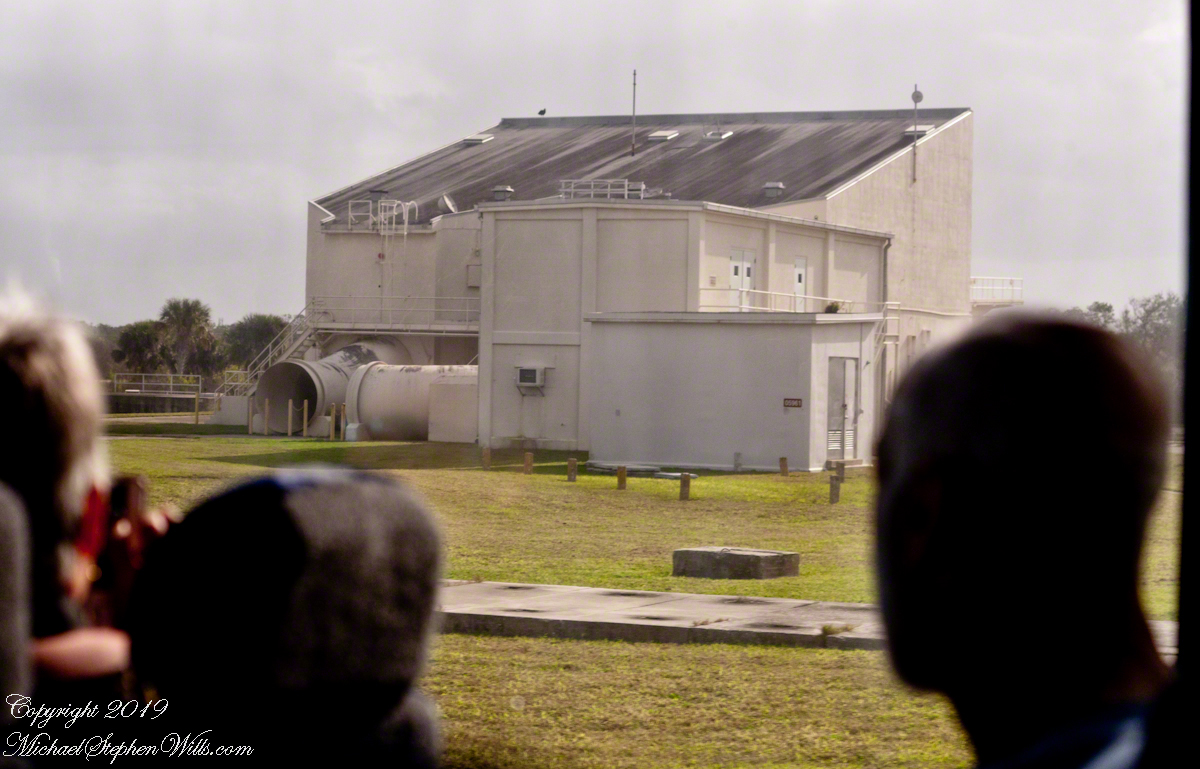
Observation Bunker
In January, 2018, firmly in the present, our bus approached these now “deactivated” sites driving down Lighthouse Road. Confined to the bus, I used my Canon EOS 1Ds Mark III and the EF 70-300mm f/4-5.6 IS USM lens to capture these scenes.
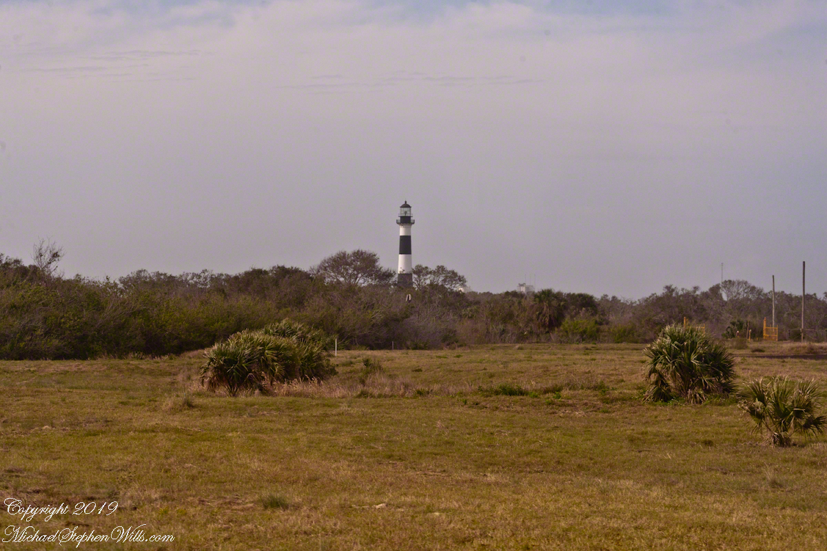
Looking across Launch Complexes 1 and 2 to Lighthouse Road and the tower. An observation bunker Observation Bunker from Launch Complex 3, looking across Launch Complex 1.
I can almost see someone behind the glass, enjoying a blast of air-conditioned air, dry and cool.
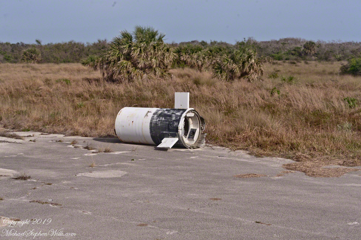
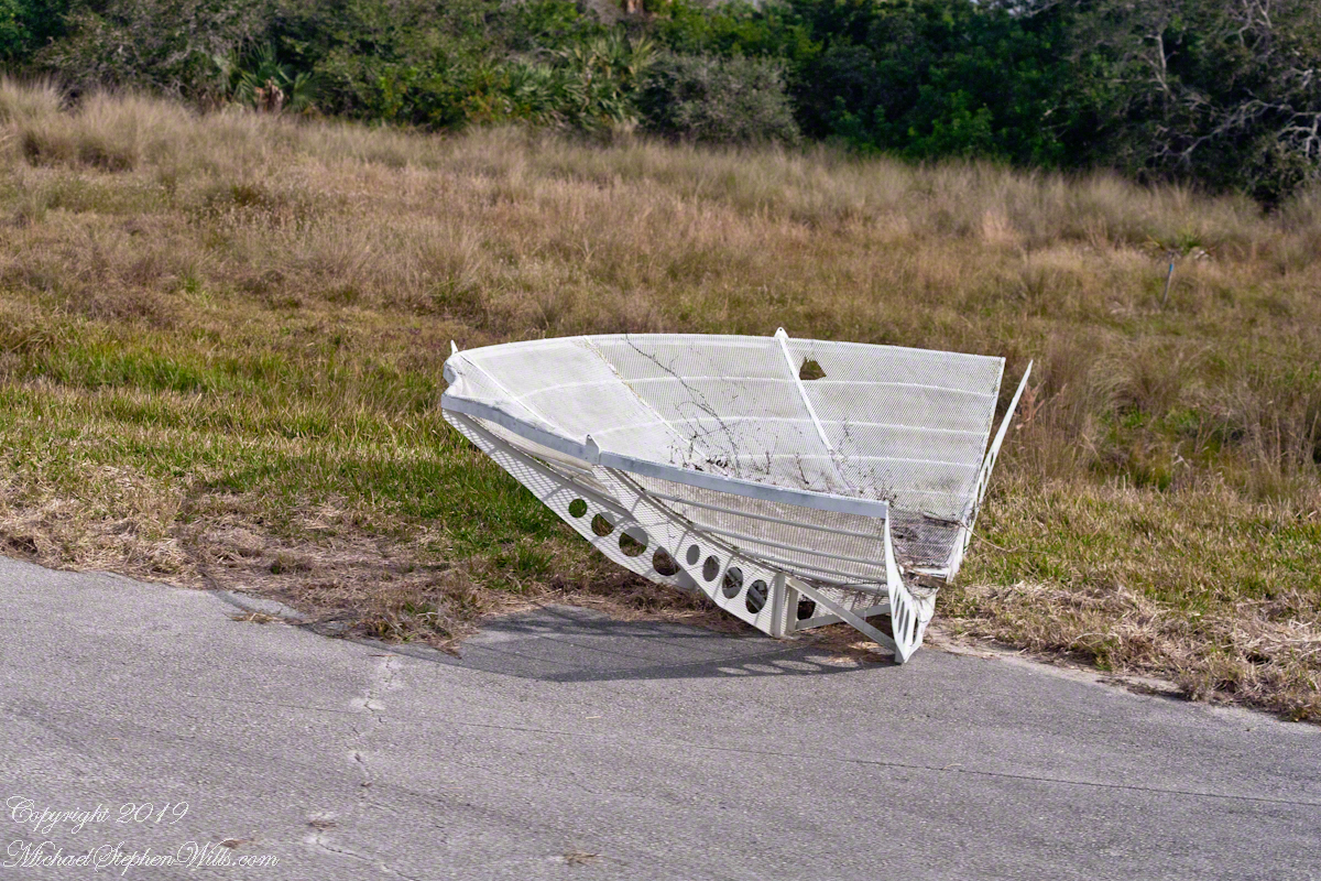
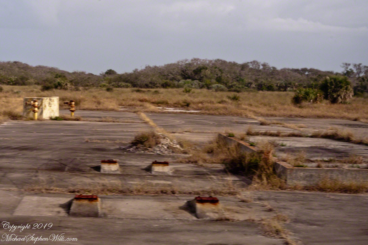
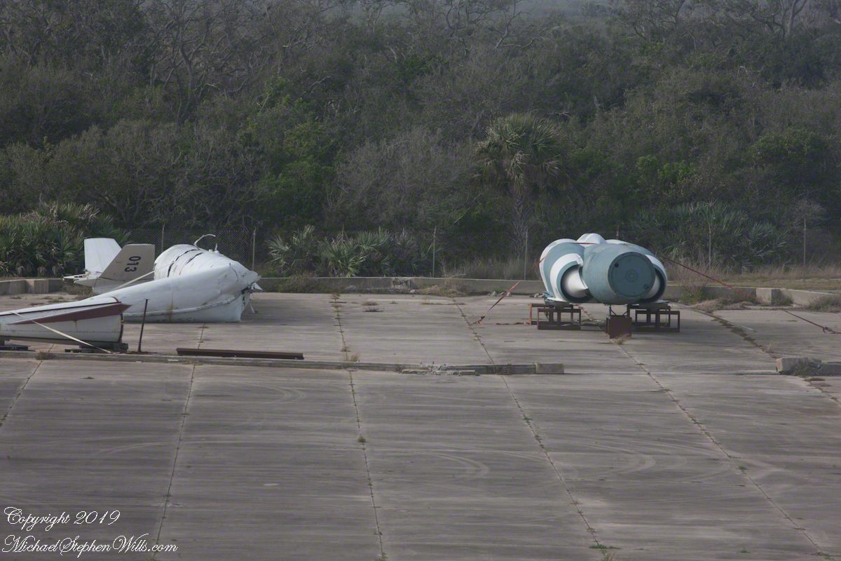
Litter on and around Launch Complex 4
Missile Housing without Engine Radar Parabola FragmentCement Blacked by Rocket Launch Blasts
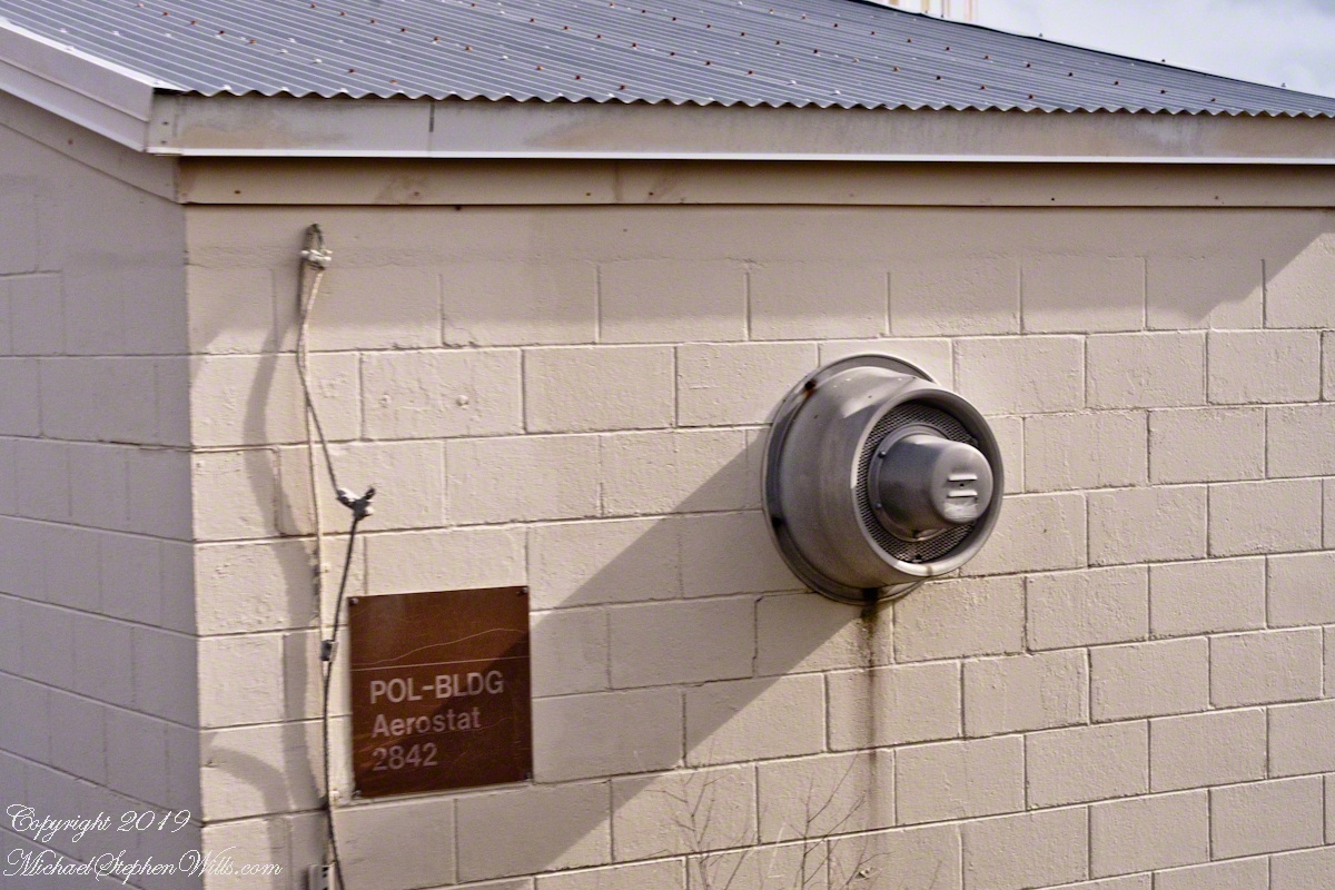
Aerostat
From 1950 into the 1960’s LC 1-4 saw launches of cruise missiles, some of which were able to maneuver and land on the “skid strip” you can pick out on the “21,000 V2 Victims” image, above. A positive discovery from my research on wikipedia the weapon systems tested here were not fired in anger. Continued development in other places lead to production of generations of cruise missiles launched by Presidents Clinton and Bush against Afghanistan, Iraq and (??) other targets. What victim ghosts, arms linked in ever growing circles, are lurking in our future?
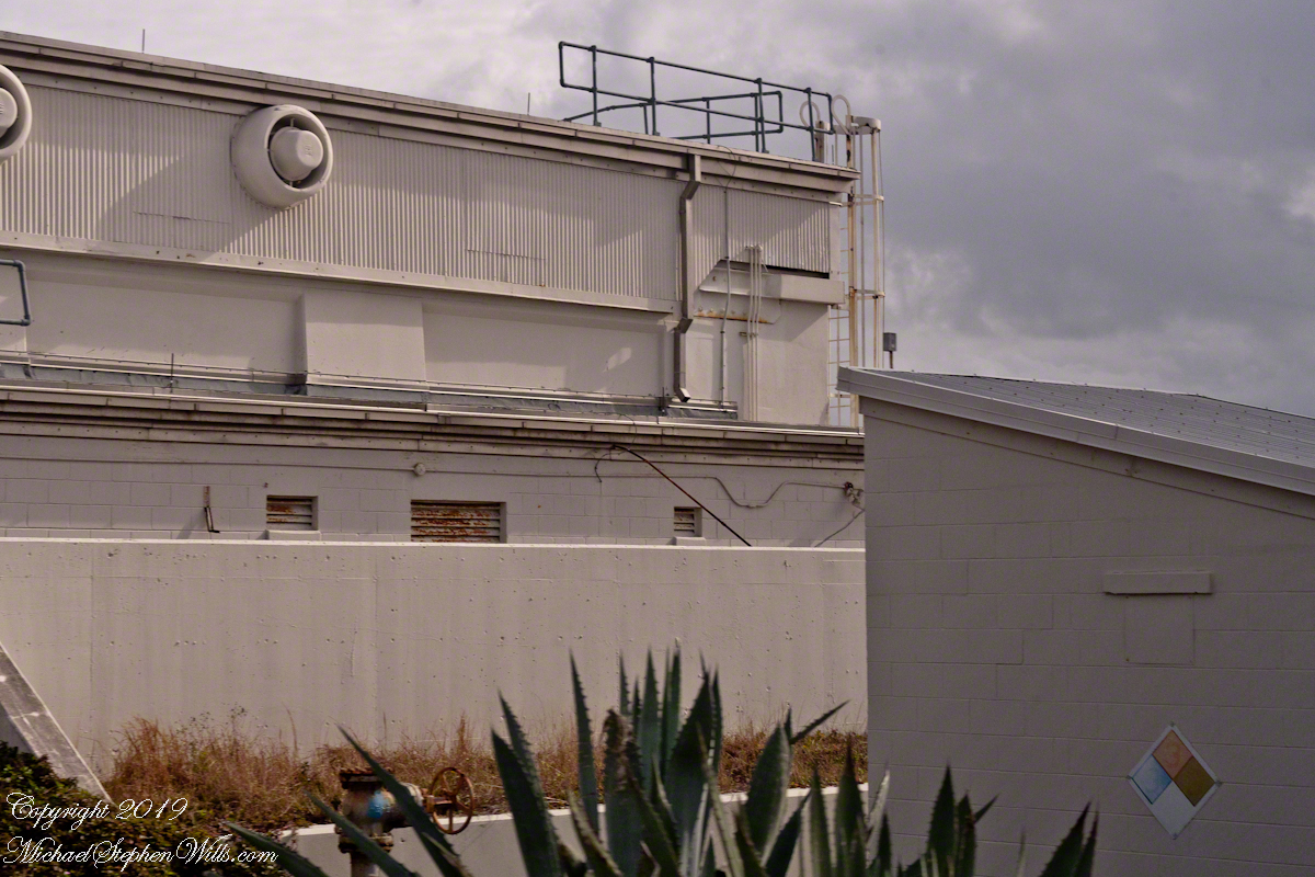
A building on LC 4 has the designation “Aerostat”, one of the last projects supported. I saw an aerostat in action in the early 2000’s over Fort Huachuca, Arizona near the border with Mexico. An aerostat is a flying craft that does not rely on moving air to achieve lift, balloons for example.
The Goodyear blimp is a memory from my childhood on Long Island, the Fort Huachuca aerostat was a smaller version, outfitted with advanced technology for monitoring the surrounding environment. “Google” aerostat mexican border to learn more about the current deployment.
Another view of the abandoned aerostat building on LC 4
With the development of Intercontinental Ballistic Missiles (ICBMs) the facilities of LC 1 – 4 became obsolete. ICBMs are a theme of the next installment of this series.
Sources of information for this post: I used information from the Wikipedia site for the key words V-2, Launch Complex 1, Launch Complex 2, Launch Complex 3, Launch Complex 4. The Bumper 8 launch photograph caption includes a source citation.
Copyright 2024 Michael Stephen Wills All Rights Reserved.
Here is the fourth in a series of photographs centered on the early history of space flight on Cape Canaveral mostly taken during a tour organized by the Cape Canaveral Lighthouse Foundation. Google the foundation for details of future tours. Here we explore the sites closests to the Lighthouse: Launch Complex 21 and 22.
“Vengance Weapons” re-purposed
Vergeltungswaffe 1 (Vengance Weapon 1 AKA V-1), produced at Peenemünde on the Baltic Sea was first used against Great Britan by Germany one week after the D-day landings. 8,025 of these flying bombs, the first cruise missles, caused the death of 22,892 people, mostly civilians. The first cruise missles for the USA were developed less than 1,000 feet away from the lighthouse. After touring the lighthouse we boarded the bus to visit these sites, Launch Complex 21 and 22.
Click Any Image for a larger viewe
Launch Complex 21 and 22 are marked with a labled “pin” on this image from Google Earth.
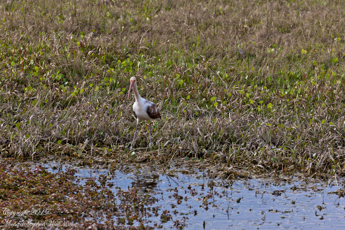
Nature abounds in Cape Canaveral Air Force Station. This ibis hunted near the lighthouse on our way to Launch Complexes 21,22.
We passed close to the blockhouse first viewed in my post, “Lighthouse and Rockets,” and I captured this detail of the long abandoned structure. The last test launch of a Mace missle was June, 1960.
This wreckage photograph was part of my,“Lighthouse and Rockets” post. It was taken from a lighthouse portal. It is a type of cruise missle, although I cannot identify the exact type, comparing the engine, on the right, with available photographs of the “Bull Goose” and “Mace” missles developed here.
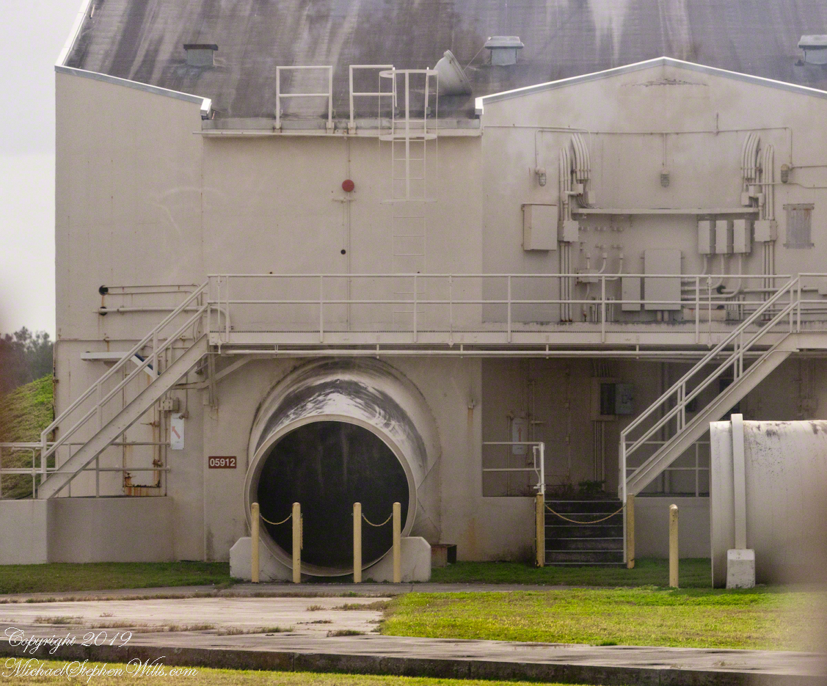
Bull Goose and Mace
Rail launched, as was the German V-1, the missles developed here were called “Bull Goose” and “Mace.” Bull Goose was a delta winged craft intended as a decoy, to appear on radar as a strategic bomber during a nuclear attack. At that time, the rails were in the open. The building here was a revampment of the site for development of the Mace. The other side of this structure is open, the launch rail pointed up from the rear. There are two launch rails, numbered 1 and 2. The building placard is “05961,” the numeral “1” designates site 1. The use of numbers of designate a site is unusual. Letters are used elsewhere on Cape Canaveral and Kennedy Space Center.
The powerful rocket exhause was directed though these pipes. Site 1 is on the right.
Guidance or “Cruise Control”
Navigation is a crucial requirement for cruise missles. The Bull Goose used a gyroscope with no reference to surroundings. The guidance system held the launch bearings, a successful flight was completed within 115 nautical miles of the target.
If deployed, the plan was for thousands of these missles to launch 1 hour before the attack craft set out and 1 hour after. The missles were not armed, but would descend in the thousands around the targets. Similar to what the Germans did to civilians in England.
After three years and 136.5 million dollars the Bull Goose was cancelled because it could not simulate either the B-47 Stratojet or B-52 Stratofortress nuclear bomb delivery aircraft. Not a single decoy was fired in anger.
The building sign “05912” identifies this exhaust tube as being launch site 2.
The Mace, for which this building was created, used a guidance ATRAN (Automatic Terrain Recognition And Navigation, a radar map-matching system). The map was produced on a 35 mm film strip carried on the missle, the live radar returns were “matched” against the film with course correction made for differences. The Mace was of limited usefulness due to the lack of radar maps for target areas within the Soviet Union. The Mace was deployed to Germany and South Korea until phase out in 1969.
Sources of information for this post: I used information from the Wikipedia site for the key words V-1, Launch Complex 21, Launch Complex 22, Mace, Bull Goose.
Copyright 2024 Michael Stephen Wills All Rights Reserved.
Here is the third in a series of photographs centered on the early history of space flight on Cape Canaveral mostly taken during a tour organized by the Cape Canaveral Lighthouse Foundation. Google the foundation for details of future tours. Here we start with Roman Numerals and end with Rocket Research.
Inscribed Roman Numerals
We were lucky to be on this tour, for a period of time the Air Force closed off the Lighthouse. The Lighthouse Foundation obtained permission to start this tour in 2016 (this was January 2018) and I happened to discover it while poking around in preparation for the SpaceX “Falcon Heavy” launch in early February 2018.
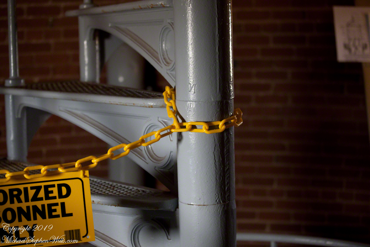
As Pam and I climbed, each floor docent (volunteer guide) was so helpful with information and hospitality. At the last floor, the stairway to the upper floors was roped off. Top levels were closed, Cape Canaveral Lighthouse is operational. Here is a photograph of the closed off staircase. There is a roman numeral “6” (VI) inscribed in the staircase column. This is the numbering system described in the first post, “Cape Canaveral Lighthouse,” by which the entire 151-foot lighthouse can be disassembled/reassembled as was done in the 19th century.
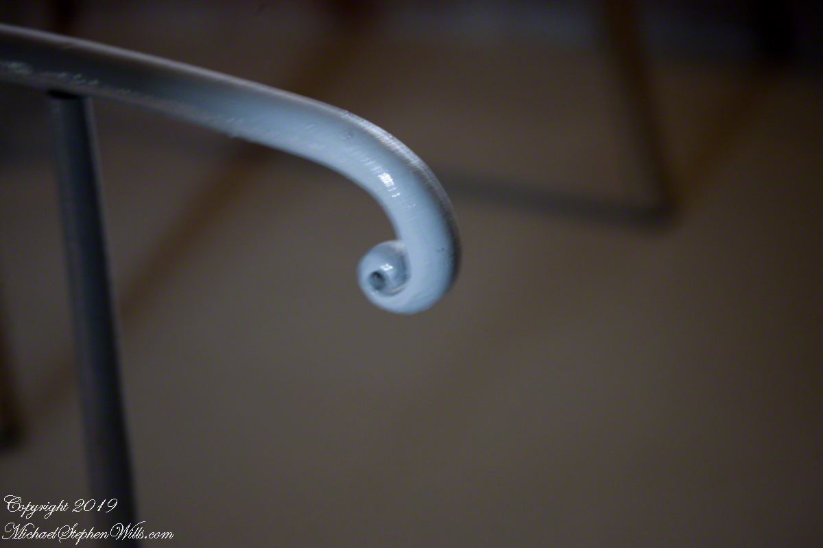
Stairway to Upper Floors
The fine finish of the handrail termination for the stairs to upper floors is an example of 19th century attention to detail.
Macro of numeral inscription on a lower floor stairway column.
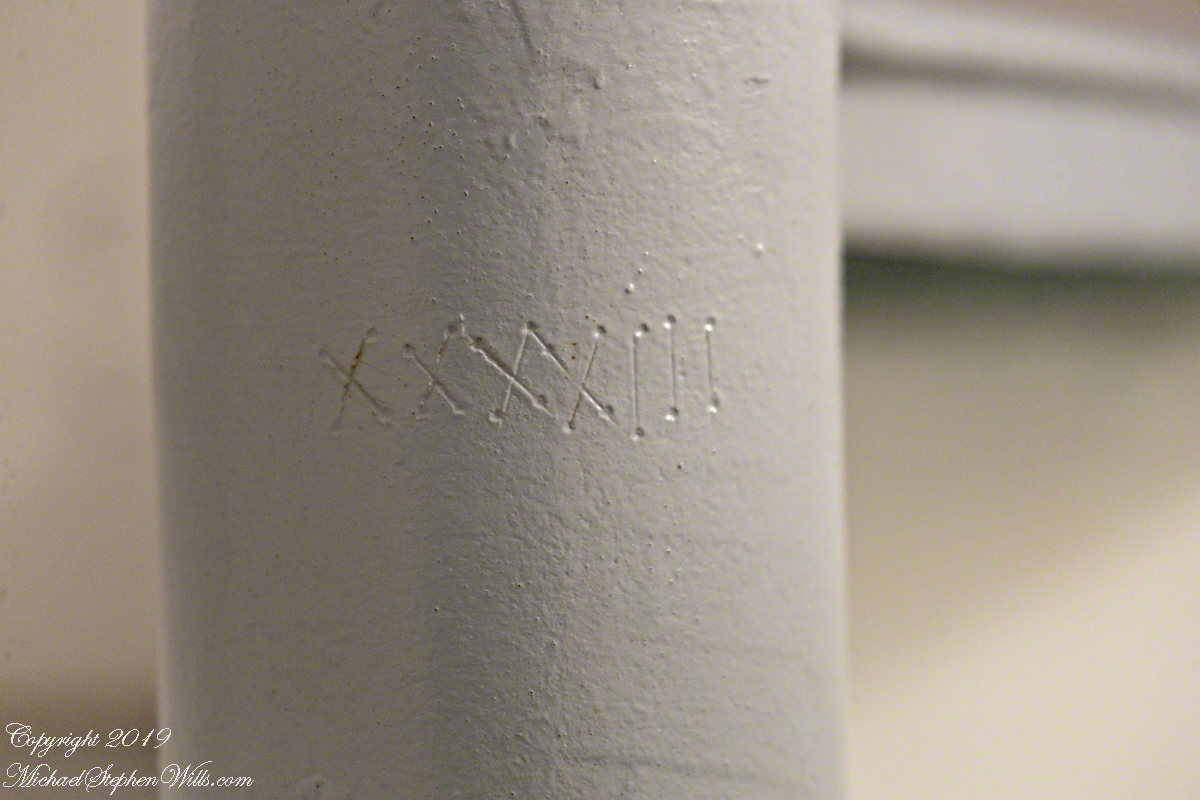
Roman Numeral 43 on staircase column of lower floor
View of Space History from the Portals
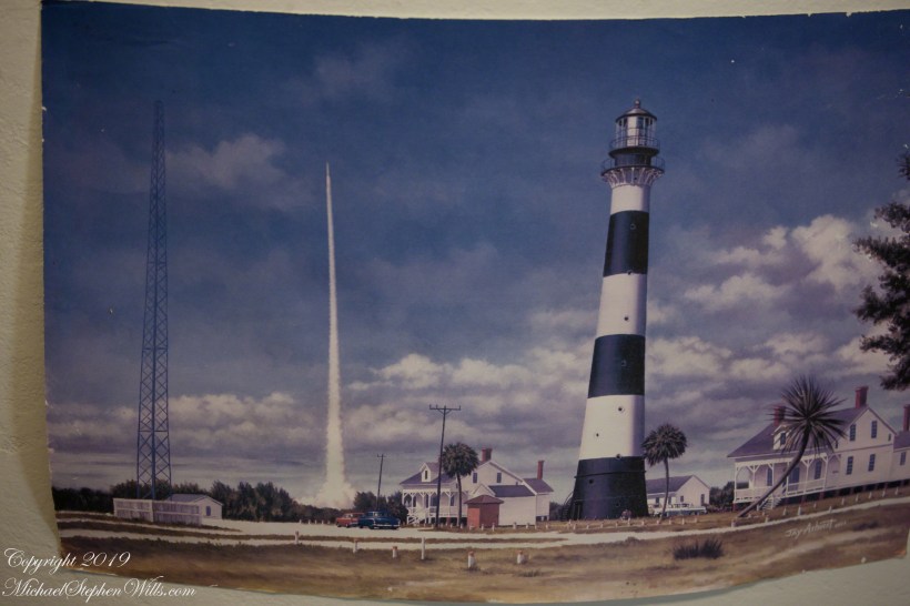
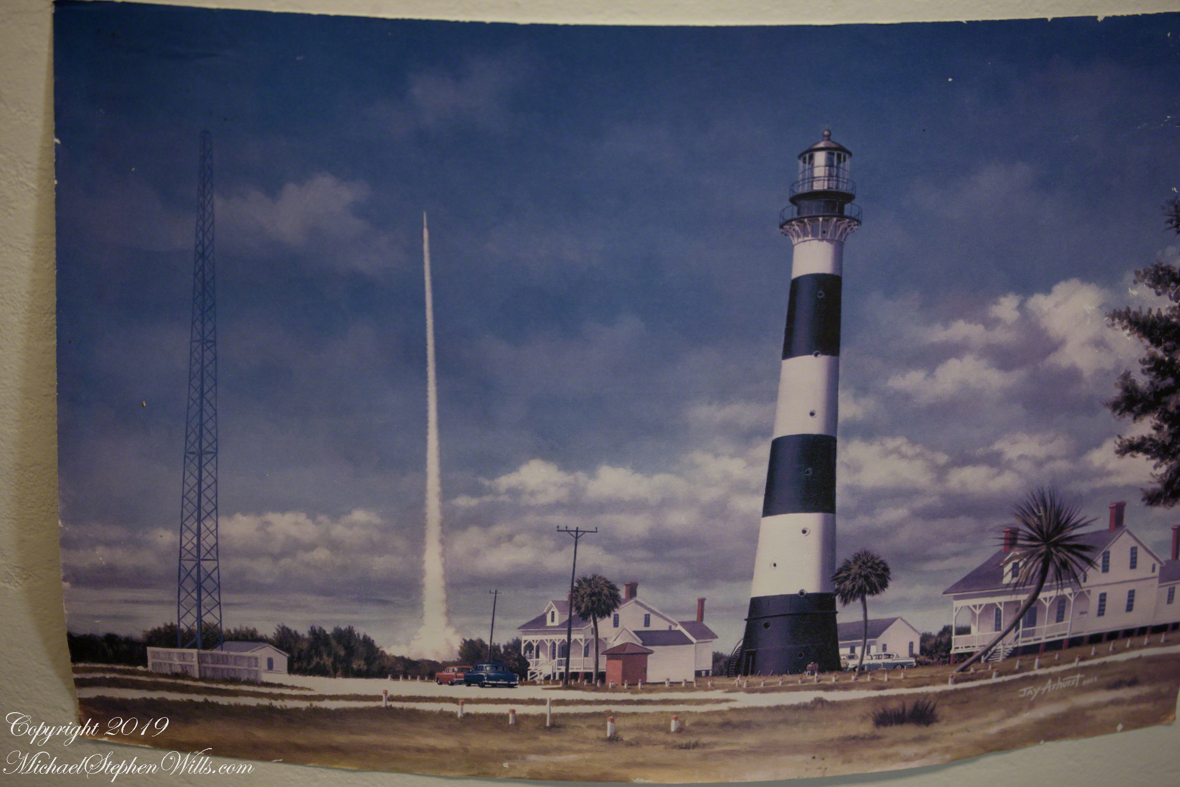
The lower staircase support column was much wider with space for illustrations and displays. Here is a reproduction of a watercolor of the lighthouse from the earliest days of rocketry on the cape. The lighthouse keeper, assistant and their families lived alongside the tower. The housing was later razed. The Lighthouse Foundation is raising money to build reproductions of the housing.
I put my copyright on the photograph to control copying. The copyright does NOT refer to the artwork.
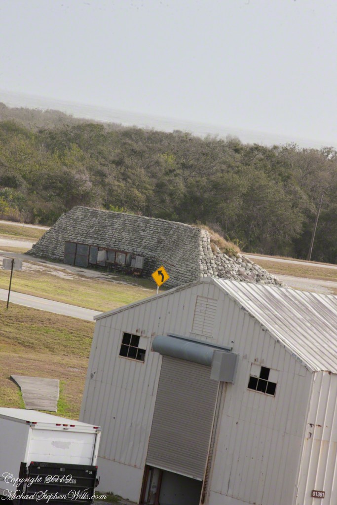
The painting is an accurate representation of the tower. The dark spots are the windows, or portals, captured in my last post, “Lighthouse Details.” Every portal offered a view of historical or current rocketry. In the following photograph, beyond the outbuilding, is a blockhouse, protection for the early rocket scientists, now abandoned. The structure services launch complex 21 and 22. More in a later post.
Wreckage with Recollections of Werner von Braun
Depending on your viewpoint, the landscape around the tower is either littered with or graced by relics such as the wreckage in the following photograph.
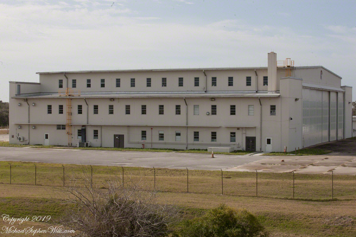
As we stood on the exterior staircase, looking toward the building in the following photograph, the docent told a story of Werner von Braun, how he loved to smoke cigarettes and watch rocket tests from the top of the lighthouse. After some spectacular failures, for reasons of personal safety he was excluded from the tower. His office during the development of the Minute Man and Persing missiles was in this building.
Building next to the lighthouse where Werner VonBraun had an office during the early days of USA rocket research.
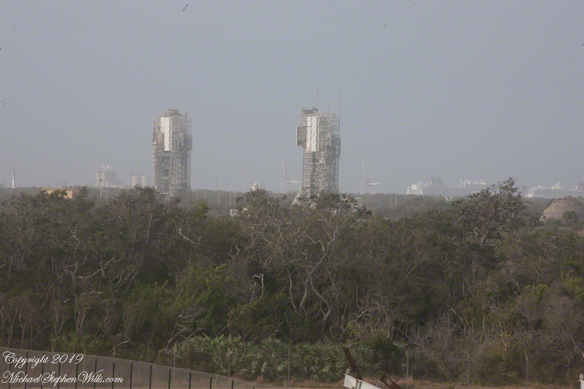
This view overlooks the former sites of Minute Man and Persing rocket development. Beyond the launch towers is Port Cape Canaveral, visible to the right are large cruise ships.
Viewed from the Cape Canaveral lighthouse, the port i is in the distance with cruise ships.
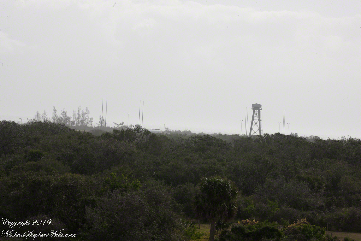
Looking from portals facing northeast is this view across ICBM road and its many launch sites. We will visit these in a future post.
Viewed from the Cape Canaveral lighthouse, these are active launch sites.